Currumbin Waters Gold Coast City, Queensland | |||||||||||||||
---|---|---|---|---|---|---|---|---|---|---|---|---|---|---|---|
Coordinates | 28°09′27″S153°28′07″E / 28.1575°S 153.4686°E | ||||||||||||||
Population | 9,797 (SAL 2021) [1] | ||||||||||||||
Postcode(s) | 4223 | ||||||||||||||
Area | 9.9 km2 (3.8 sq mi) | ||||||||||||||
Time zone | AEST (UTC+10:00) | ||||||||||||||
Location |
| ||||||||||||||
LGA(s) | City of Gold Coast | ||||||||||||||
State electorate(s) | Currumbin | ||||||||||||||
Federal division(s) | McPherson | ||||||||||||||
|
Currumbin Waters is a suburb in the City of Gold Coast, Queensland, Australia. [2] It borders New South Wales. [3] In the 2021 census, Currumbin Waters had a population of 9,797 people. [4]
Currumbin Waters is bounded to the south by the Queensland border with New South Wales, to the east by the Pacific Motorway, to the north by Guineas Creek Road, and to the west by Simpsons Road and Piggabeen Road. [3]
Currumbin Creek flows through the suburb from the south-west (Currumbin Valley) towards the north (Palm Beach and Currumbin) where it enters the Coral Sea. [3]
Currumbin Waters has a variety of land uses. North of the creek is residential. South of the creek there is an industrial estate in the north-east of the suburb ( 28°08′48″S153°28′16″E / 28.1468°S 153.4711°E ). There is a residential canal estate in the centre of the suburb ( 28°09′10″S153°27′57″E / 28.1528°S 153.4657°E ) with normal residential use in the east. In the south-east of the locality the land is used for farming, mostly grazing on native vegetation ( 28°10′02″S153°27′27″E / 28.1672°S 153.4576°E ). [3]
The name Currumbin Waters was originally a real estate development name. The name Currumbin is from the Bundjalung language (Ngaraangbal dialect), which means either high or high trees or may be a corruption of kurrohmin meaning kangaroo . [2]
St Augustine's Catholic School was established in 1926 by the Daughters of Our Lady of the Sacred Heart in Coolangatta. From 1950, the school was operated by Missionary Franciscan Sisters of the Immaculate Conception. On 27 January 1987, the school relocated to a new site in Currumbin Waters. In 1992, the sisters ended their association with the school which is now under lay administration. [5] [6] [7]
Coolangatta Special School opened on 1 January 1979 in Coolangatta. On 1 July 2006, the school was relocated to Currumbin Waters and renamed Currumbin Community Special School. [8] [9]
In the 2011 census Currumbin Waters had a population of 8,883, 51.8% female and 48.2% male. [10] The median age of the Currumbin Waters population was 42 years, 5 years above the national median of 37. 76.7% of people living in Currumbin Waters were born in Australia. The other top responses for country of birth were England 5.3%, New Zealand 4.8%, Germany 0.7%, Scotland 0.6%, South Africa 0.5%. 91% of people spoke only English at home; the next most common languages were 0.5% German, 0.5% Japanese, 0.2% Tagalog, 0.2% Portuguese, 0.2% Italian. [10]
In the 2016 census, Currumbin Waters had a population of 9,121 people. [11]
In the 2021 census, Currumbin Waters had a population of 9,797 people. [4]
St Augustine's Parish Primary School is a Catholic primary (Preparatory to Year 6) school for boys and girls at Galleon Way ( 28°09′01″S153°27′34″E / 28.1502°S 153.4594°E ). [12] [13] In 2017, the school had an enrolment of 463 students with 32 teachers (25 full-time equivalent) and 17 non-teaching staff (10 full-time equivalent). [14]
Currumbin Community Special School is a special government primary and secondary (Preparatory to Year 12) school for boys and girls at 5 Hammersford Drive ( 28°09′07″S153°28′21″E / 28.1519°S 153.4725°E ). [12] [15] In 2017, the school had an enrolment of 87 students with 31 teachers (24 full-time equivalent) and 28 non-teaching staff (19 full-time equivalent). [14]
There are no mainstream government primary nor secondary schools in Currumbin Waters. The nearest government primary schools are Elanora State School in neighbouring Elanora to the north and Currumbin State School in neighbouring Currumbin to the north-east. The nearest government secondary schools are Elanora State High School in Elanora and Palm Beach-Currumbin State High School in neighbouring Palm Beach to the north-east. [3]
Coolangatta is a coastal suburb in the City of Gold Coast, Queensland, Australia. It is the Gold Coast's southernmost suburb and it borders New South Wales. In the 2016 census, Coolangatta had a population of 5,948 people.
Burleigh Heads is a suburb in the City of Gold Coast, Queensland, Australia. In the 2016 census, Burleigh Heads had a population of 10,077 people.
Currumbin is a coastal suburb in the City of Gold Coast, Queensland, Australia. In the 2016 census, Currumbin had a population of 2,920 people.
Palm Beach is a coastal suburb in the City of Gold Coast, Queensland, Australia. In the 2016 census, Palm Beach had a population of 14,654 people.
The City of Gold Coast is the local government area spanning the Gold Coast, Queensland, Australia and surrounding areas. With a population of 606,774 it is the second most populous local government area in the State of Queensland. Its council maintains a staff of over 2,500. It was established in 1948, but has existed in its present form since 2008. It is on the border with New South Wales with the Tweed Shire to the south in New South Wales.
Burleigh Waters is a suburb in the City of Gold Coast, Queensland, Australia. In the 2016 census, Burleigh Waters had a population of 14,310 people.
Bilinga is a southern coastal suburb in the City of Gold Coast, Queensland, Australia. It is on the border with New South Wales. In the 2021 census, Bilinga had a population of 1,883 people.
Shailer Park is a suburb in the City of Logan, Queensland, Australia. In the 2016 census, Shailer Park had a population of 11,759 people.
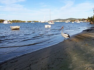
Noosaville is a town and suburb in Noosa in the Shire of Noosa, Queensland, Australia. In the 2016 census, Noosaville had a population of 8,124 people.
Buddina is a coastal suburb of Kawana Waters in the Sunshine Coast Region, Queensland, Australia. In the 2016 census, Buddina had a population of 3,885 people.
Mermaid Waters is a suburb in the City of Gold Coast, Queensland, Australia. In the 2016 census, Mermaid Waters had a population of 12,045 people.
Elanora is a suburb of the City of Gold Coast in Queensland, Australia. In the 2016 census, Elanora had a population of 12,145 people.
Clear Island Waters is a suburb of the City of Gold Coast in Queensland, Australia. In the 2016 census, Clear Island Waters had a population of 4,120 people.
Arundel is a suburb in the City of Gold Coast, Queensland, Australia. In the 2016 census, Arundel had a population of 10,246 people.
Tallebudgera is a suburb in the City of Gold Coast, Queensland, Australia. In the 2021 census, Tallebudgera had a population of 3,826 people.
Mount Warren Park is a residential suburb in the outer eastern area of City of Logan, Queensland, Australia. The mountain Mount Warren is within the suburb. In the 2016 census, Mount Warren Park had a population of 5,791 people.
Coomera is a town and suburb in the City of Gold Coast, Queensland, Australia. In the 2016 census, Coomera had a population of 13,305 people.
Pelican Waters is a suburb of Caloundra in the Sunshine Coast Region, Queensland, Australia. In the 2016 census, Pelican Waters had a population of 6,277 people.
Currumbin Valley is a rural locality in the City of Gold Coast, Queensland, Australia. It borders New South Wales. In the 2021 census, Currumbin Valley had a population of 2,084 people.