
A canal estate, canal development, waterway estate or marine suburb is a residential subdivision made up of canals and reclaimed land, such that many or all of the lots can incorporate a private mooring or boat ramp.
A canal estate, canal development, waterway estate or marine suburb is a residential subdivision made up of canals and reclaimed land, such that many or all of the lots can incorporate a private mooring or boat ramp.
Canal estates are typically constructed on floodplains or swampland in estuaries, providing ready access to larger waterways and the ocean. To build the estate, civil contractors will dredge parts of the site to create deep, navigable channels, and use the resulting fill to form islands and headlands above the flood level. The resulting street layout shows a distinctive 'finger' pattern.
Canal estates are distinct from earlier canal cities such as Venice and Amsterdam in that the channels serve a purely recreational, as distinct from commercial or security, purpose.[ citation needed ]
Canal estates originated in the United States, where developer Abbot Kinney sought to create a Venice-like city in swampland on the outskirts of Los Angeles. Kinney's "Venice of America" opened in 1905, but pressure to accommodate automobiles saw more than half the canals filled in to create roads in 1929. The canal estate model proved more resilient on the east coast, where they are a significant part of the urban structure of Cape Coral, Fort Lauderdale and Miami in Florida.
Queensland's South Coast (now known as the Gold Coast) had enjoyed rapid growth as a playground for Brisbane holidaymakers. When wartime restrictions on construction were relaxed in 1952, there was considerable demand for housing in the region. [1]
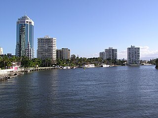
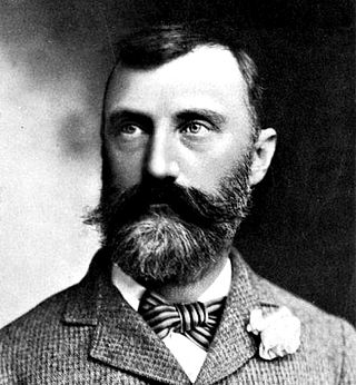
Australian real estate agent Alfred Grant is credited with importing the canal estate concept from Florida and Hawaii in the United States. [2] The Gold Coast provided the ideal conditions: expensive coastal sites bordered by cheap floodplain and mangrove swamp. Working with celebrated Austrian town planner Karl Langer, Grant created Australia’s first “man-made waterway estates”, Miami Keys and Rio Vista, at Broadbeach in 1957. [2] [3] [4] On the opposite side of the Nerang River, Bruce Small started to build Paradise City, with the Isle of Capri as its glitzy centrepiece. When his calls for a comprehensive city plan fell on deaf ears, Small entered politics and represented the area as mayor or MP from 1967 to 1978. [5] [6]
Legislation governing these neighbourhoods followed the initial developments in the form of the Canals Act 1958 (Qld). Recognising the risk of flood, the city council mandated that one pound from the sale of every lot should go to a University of Queensland project studying mitigation strategies. The result of this work was the Benowa Flood By-Pass Canal, completed in 1980. [7]
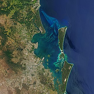
Canal development emerged as the defining characteristic of the Gold Coast’s urban form: today the city is home to more than 890 kilometres of canals. Isolated examples emerged elsewhere in Australia, however. Grant himself championed Kawana Waters on the Sunshine Coast in 1961, though the project was plagued by construction delays and slow sales. [2] Real-estate firm LJ Hooker built Sylvania Waters in southern Sydney in 1965. [8] Further developments on the Sunshine Coast followed, as well as projects in Bunbury, Cairns, the Central Coast, Forster, Geographe, Hervey Bay, Lakes Entrance, Port Macquarie, Sussex Inlet, Tweed Heads, Yamba and each of the other mainland State capitals.

The Gold Coast, often referred to by its initials G.C., and officially the City of Gold Coast, is the nation's sixth-largest city, most populous non-capital city in the Australian state of Queensland and the state's second-largest city after Brisbane, with a population over 600,000. The Gold Coast is a coastal city and region located approximately 66 kilometres (41 mi) south-southeast of the centre of the state capital Brisbane. The city's central business district is located roughly in the centre of the Gold Coast in the suburb of Southport. The urban area of the Gold Coast is concentrated along the coast sprawling almost 60 kilometres, joining up with the Greater Brisbane Metropolitan Area to the north and to the state border with New South Wales to the south. Nicknames of the city include, the ‘Glitter Strip’ and the ‘Goldy’. The demonym of a Gold Coast resident is Gold Coaster.

A swamp is a forested wetland. Swamps are considered to be transition zones because both land and water play a role in creating this environment. Swamps vary in size and are located all around the world. The water of a swamp may be fresh water, brackish water, or seawater. Freshwater swamps form along large rivers or lakes where they are critically dependent upon rainwater and seasonal flooding to maintain natural water level fluctuations. Saltwater swamps are found along tropical and subtropical coastlines. Some swamps have hammocks, or dry-land protrusions, covered by aquatic vegetation, or vegetation that tolerates periodic inundation or soil saturation. The two main types of swamp are "true" or swamp forests and "transitional" or shrub swamps. In the boreal regions of Canada, the word swamp is colloquially used for what is more formally termed a bog, fen, or muskeg. Some of the world's largest swamps are found along major rivers such as the Amazon, the Mississippi, and the Congo.

Brisbane is the capital and most populous city of Queensland and the third-most populous city in Australia and Oceania, with a population of approximately 2.6 million. Brisbane lies at the centre of South East Queensland, which includes several other regional centres and cities. The central business district is situated within a peninsula of the Brisbane River about 15 km (9 mi) from its mouth at Moreton Bay. Brisbane is located in the hilly floodplain of the Brisbane River Valley between Moreton Bay and the Taylor and D'Aguilar mountain ranges. It sprawls across several local government areas, most centrally the City of Brisbane. The demonym of Brisbane is Brisbanite.
Moreton Bay is a bay located on the eastern coast of Australia 14 kilometres (8.7 mi) from central Brisbane, Queensland. It is one of Queensland's most important coastal resources. The waters of Moreton Bay are a popular destination for recreational anglers and are used by commercial operators who provide seafood to market.

The Logan River is a perennial river in the Scenic Rim, Logan and Gold Coast local government areas of the South East region of Queensland, Australia. The 184-kilometre (114 mi)-long river is one of the dominant waterways in South East Queensland that drains the southern ranges of the Scenic Rim and empties into Moreton Bay after navigating the City of Logan, a major suburban centre located south of Brisbane. The catchment is dominated by urban and agricultural land use. Near the river mouth are mangrove forests and a number of aquaculture farms.
The Nerang River is a perennial river in South East Queensland, Australia. Its catchment lies within the Gold Coast local government area and covers an area of 490 square kilometres (190 sq mi). The river is approximately 62 kilometres (39 mi) in length.

Caloundra is a coastal town and the southernmost town in the Sunshine Coast Region in South East Queensland, Australia.

Brisbane's recorded history dates from 1799, when Matthew Flinders explored Moreton Bay on an expedition from Port Jackson, although the region had long been occupied by the Yugara and Turrbal aboriginal tribes. The town was conceived initially as a penal colony for British convicts sent from Sydney. Its suitability for fishing, farming, timbering, and other occupations, however, caused it to be opened to free settlement in 1838. The town became a municipality in 1859 and a consolidated metropolitan area in 1924. Brisbane encountered major flooding disasters in 1893, 1974, 2011 and 2022. Significant numbers of US troops were stationed in Brisbane during World War II. The city hosted the 1982 Commonwealth Games, World Expo 88, and the 2014 G20 Brisbane summit

Maroochydore is a coastal city in the Sunshine Coast Region, Queensland, Australia.

The Atchafalaya Basin, or Atchafalaya Swamp, is the largest wetland and swamp in the United States. Located in south central Louisiana, it is a combination of wetlands and river delta area where the Atchafalaya River and the Gulf of Mexico converge. The river stretches from near Simmesport in the north through parts of eight parishes to the Morgan City southern area.
Abbot Kinney was an American developer, conservationist, water supply expert and tree expert. Kinney is best known for his "Venice of America" development in Los Angeles.

Burleigh Waters is a suburb in the City of Gold Coast, Queensland, Australia. In the 2016 census, Burleigh Waters had a population of 14,310 people.

Kawana Waters is an urban centre on the Sunshine Coast in Queensland, Australia, between Caloundra and Maroochydore along the Coral Sea coast. It was originally the estate development name and has passed into common usage, but it is not officially a town nor a locality. The official suburbs are connected by the Nicklin Way arterial road. It is sometimes abbreviated to Kawana, which is a suburb of Rockhampton.
Parrearra is a suburb in the Sunshine Coast Region, Queensland, Australia. In the 2016 census, Parrearra had a population of 4,468 people.

Warana is a coastal suburb of Kawana Waters in the Sunshine Coast Region, Queensland, Australia. In the 2016 census, Warana had a population of 3,688 people.
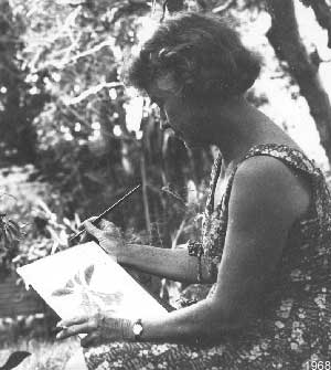
Kathleen McArthur (1915–2000) was an Australian naturalist, writer, botanical illustrator and conservationist. She was born in Brisbane, Queensland, to Catherine and Daniel Evans. Her mother was a daughter of the Durack pastoral family, her father a co-founder of the engineering firm Evans Deakin and Company. She married Malcolm McArthur in 1938 and had three children before divorcing in 1947. From 1942 she lived at Caloundra on the Sunshine Coast, Queensland.

The Maroochy River is a river in South East Queensland, Australia. The river rises from the eastern slopes of the Blackall Range and flows east through Eumundi before entering the sea at Cotton Tree, Maroochydore. Other populated centres in the catchment include Nambour, Eudlo, Yandina and Coolum.
Mitchell Lake is a small, artificial lake in the Great Lakes Basin and located in the city of Kawartha Lakes in Central Ontario, Canada. The lake was formed sometime in the first decade of the twentieth century alongside the construction of the Kirkfield Lift Lock, which was completed and operational by the end of 1907. It is part of the summit of the Trent–Severn Waterway, the middle of a connection via canals of Balsam Lake on the Gull River system, which flows eventually to Lake Ontario, and the Kirkfield Lift Lock and Canal Lake on the Talbot River system, which flows to Lake Simcoe and eventually to Lake Huron.
Pelican Waters is a suburb of Caloundra in the Sunshine Coast Region, Queensland, Australia. In the 2016 census, Pelican Waters had a population of 6,277 people.

The geography of Brisbane is characterised by its coastal location in the south eastern corner of the Queensland state of Australia. It is located halfway up the Australian east coast with longitudinal and latitudinal coordinates of 27.5° south and 153° east. The city resides within the Moreton Bay Floodplain, stretching from Caboolture to the north, Beenleigh to the south and as far as Ipswich to the west whilst being bordered by the Pacific Ocean to the east.