1920 flyer promoting canals as "America's most unique attraction"
The Venice Canal Historic District is embedded in the residential Venice suburb of Los Angeles, California. The historic district is noteworthy for possessing man-made wetland canals, built in 1905 by developer Abbot Kinney as part of his Venice of America. Kinney sought to recreate the appearance and feel of Venice, Italy, in coastal Los Angeles County. The names of the canals were given by Abbot Kinney as follows: Aldebaran Canal, Altair Canal, Cabrillo Canal, Coral Canal, Grand Canal, Lion Canal and Venus Canal.
Another set of canals was built south of the Venice Canals, originally known as the New Amsterdam Canals by investors and architects, namely Howland, Sherman and Clark, land owners whom two canals were named after. These canals are roughly bounded by Eastern Court on the east, Court A on the south, Strongs Drive on the west, and Court E on the north. There are four east-west canals (Carroll Canal, Linnie Canal, Howland Canal, and Sherman Canal) and two north-south canals (Eastern Canal and Grand Canal). The lit canals with gondoliers and arched bridges drew widespread publicity and helped sell lots in the development.
By the 1920s, with cars quickly gaining popularity, the canals were viewed by many as outdated, and as a result a number of canals were filled in 1929 to make room for paved roads. By 1940 the remaining canals had fallen into disrepair, and the sidewalks were condemned by the city.[2] The district remained in poor condition for more than 40 years; numerous proposals to renovate the canals failed due to lack of funding, environmental concerns, and disputes as to who should bear the financial responsibility. The canals were finally renovated in 1992; they were drained, and new sidewalks and walls were built. The canals re-opened in 1993, and have become a desirable and expensive residential section of the city.
The residential district surrounding the remaining canals was listed on the National Register of Historic Places in 1982. However, in recent years, there has been extensive renovation work on many of the old houses, and many large, modern houses have been built.
The water enters the canals through sea gates in the Marina Del Rey breakwater via the Ballona Lagoon, and again in Washington Boulevard. They open at low tide to drain most of the water, and at high tide they are closed, trapping the water for about three days, before being refreshed again.
Former canals
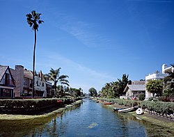
Aldebaran Canal, Venice, Calif.
Before 1929, the area covered by canals was approximately three to four times as large as today. The number of canals was reduced from thirteen to six. The canals were bounded by Abbot Kinney Blvd., Pacific Ave., Westminster Ave., and Venice Blvd. The seven canals were renamed as concrete roads by the City of Los Angeles as Main St. and Canal St. (formerly Coral Canal), Cabrillo Ave. (formerly Cabrillo Canal), San Juan Ave. (formerly Venus Canal), Windward Ave. (formerly Lion Canal), Altair St. (formerly Altair Canal), Market St. (formerly Aldebaren Canal) and Grand Boulevard (formerly Grand Canal)[3]
The traffic circle at Pacific and Windward Avenues is located on top of what once was the Venice Lagoon.[4]
Canal improvement project
Bungalows on the Venice Canals, 2011
There were several attempts to rehabilitate, restore or improve the canals. In most of these cases the projects were met with opposition, eventually causing the plans to stall and eventually be cancelled. One of these attempts was a deep-water plan that was stopped in the 1960s. Initially the deep water plan had received City of Los Angeles approval. Assessments were sent to the property owners, and Mayor Thomas Bradley did a news photo with local residents of the first shovel. This project was to include access by large boats from Marina Del Rey into the Venice Canals. However, a lawsuit by Summa Corporation, the Howard Hughes Company, and a man named Mr. Green stopped the project. This was due to the canal water flowing from Marina Del Rey to the Venice Canals in a section called Ballona Lagoon. The Ballona Lagoon property under the water was owned by Howard Hughes and the Summa Corporation. Howard Hughes died in 1976, taking away any serious opposition from Summa Corporation.
A neighborhood group, the Venice Canals Resident and Homeowners organization, was formed by a few residents of the canals in 1977, to establish an assessment district to restore the canals. This organization name was shortened to The Venice Canals Association in 1983. The VCA obtained signatures of 77% of the property owners to form an assessment district and have the Venice Canals restored or rehabilitated. The VCA submitted to the city, and as a result the city engineers began to design a new canal improvement plan to bring back to the community. This plan was designed by Los Angeles City Engineer Luis Ganajas. Luis Ganajas was a bridge engineer. He was later credited with the street improvement project for Santa Monica Blvd. from the 405 Freeway to Beverly Hills.[5]
The plan was presented to the VCA and residents with support and optimism. This plan was similar to the 1960s plan, with straight vertical cement walls, but only five feet high. This plan was designed for human-powered boats and not deep bottom boats. No deeper dredging would be required. The plan became known as the "Vertical Wall plan". The city began to move it through the process, and estimated the cost to be around 6 to 8 million, plus the city improvements of public areas like sidewalks, etc. for a total of 15 to 18 million dollars. The cost under the assessment would be shared half by the property owners over 10 years assessment on their property taxes, and half by the City of Los Angeles and the Federal government. The original assessment project was sponsored by the Venice Canals Association (VCA) in 1977 during Pat Russel's term as City Councilperson. The first attempted design was done by City of Los Angeles Engineer Luis Ganajas.[5] The plan still faced opposition. Those opposing any improvements did not want to see the sidewalks returned to public use, did not want to pay for the assessment, and used the fish and wildlife as a red herring. Some mentioned the California Least Tern as an endangered species who foraged and fished in the Canals. However, the majority of the residents supported the plan submitted by the City of Los Angeles.
In 1983, Ruth Galanter was elected to the City Council office and inherited the Vertical Wall plan neighborhood sponsored assessment for improving the Venice Canals. The design was known as the vertical wall plan, similar to the Marina Del Rey walls. Ruth Galanter was not happy with the environmental aspects, the costs, the Historical design and the safety of the Vertical wall plan, so one of her early actions was to stop the city engineers from pursuing such a plan. Galanter asked the Coastal Conservancy to review the options for the canals, and the state agency returned several plans suggestions, including one using a material called Armorflex. Armorflex was a web of open cement blocks that would allow for plants to grow in them. These were to be installed on a gentle slope to allow birds and wildlife to go in and out of the canals.
The majority of the neighbors who would be assessed by the new design were opposed to the Armorflex plan. Ruth told the head of the VCA improvement project, Mark Galanty, that she would be open to another plan if the VCA were to find something better. However, Councilwoman Galanter would continue with the new Armorflex plan. So Mark assembled a committee of the VCA to locate a new material. Loffelstein, or Loffel Block, was identified by a VCA site committee member Andy Shores as possibly meeting those goals. It allowed plants to grow inside the material, could be placed on a slope to allow birds and wildlife to climb out of the canals, was safe for small children as it allowed them to hold on to the sides, and or climb out of the Canals, and was lower cost than the Armorflex. Mark obtain the services of a local architect to help present an artist rendering of the Loffel Block plan. The first drawing included 55% banks with areas near the public areas at a more gentle slope to allow for birds and wildlife to enter and exit the canals. The plan was presented by Mark Galanty at a public hearing on the project. Councilwoman Galanter agreed to look at the alternative design.
Ruth agreed, and instructed the City Engineers to design a plan using the Loffel Block. However, they did not drop the Armoflex design. Meanwhile, the residents were polled: 78% were against the canals being redone using Armorflex, and 82% were in favor of the canals being redone using the Loffel Block. Councilwoman Galanter and City Engineers drop the gentle slope, and designed the entire project at 55 degrees. A test site was installed at Sherman Canal and Dell for the Armorflex. The Venice Canals Association was able to get the distributor of Loffel Block to install the Loffel test site across the canals from the Armorflex site. Both were planted with native salt water plants, and observed for quality. The ducks preferred the Loffel Block. Many of the plants died in the Armorflex. In addition, the Armorflex began to sag and shift, while the Loffel test site remained stable.
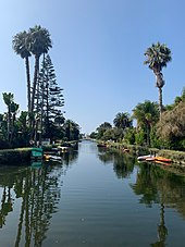
Venice Canals, 2019
After several years of study and review of both materials, Mark Galanty sent a letter to Ruth Galanter congratulating her on her success. She was able to meet her original goal of finding a material that would allow plants to grow, was environmental qualities, was safer for children falling in, was lower-cost than the original vertical wall plan, was closer to the original 1906 historic banks, and was approved by Coastal Commission and the many city agencies involved. The winner was the Loffel Block, and it now had the majority support needed for the assessment district to be approved. Based on this Letter, Councilwoman Galanter dropped the Armorflex plan and only brought forward the Loffel Plan. Mark Galanty, worked with the residents, property owners, and canal stakeholders to eliminate any opposition to the compromise plan using Loffel Block. The VCA negotiated a fund to pay for anyone that could not afford the assessment amount. No-one applied for the money established in this fund. The city designed the restoration to be built in two phases in order to not disrupt the wildlife (tern, Coots, egrets, herons, ducks, etc.).
A welcome sign to the Venice Canals in 2023. The sign has been graffitied with stickers and markers.
Meanwhile, Councilwoman Galanter, negotiated a deal with the Summa Corporation, and other property owners under the Ballona Lagoon, to eliminate any issues with water flow rights to the Venice Canals. A deal was struck between the major underwater land owner to swap the city owned lots on the Venice Canals for land under the lagoon. Assuring the Lagoon and water to the Venice Canals would continue to flow in and out. The final hearing was the Coastal Commission, where there was no opposition to the Venice Canal Improvement project. Mark Galanty spoke on behalf of the Venice Canals Association. There were over 48 supporters in favor of the project, and no one spoke against it. Due to the signal of support from the staff and Coastal Commissioners, most of those in favor of the project passed on speaking.
Instead of street addresses, homes are addressed by their canal. These canal signs are in a state of disrepair before the 2023 April cleaning to get rid of annual algae blooms
Councilwoman Galanter, and staff member Jim Bichart, as well as City Engineers Luis Ganajas, environmental engineer Russ Ruffing worked on the City, State and National approvals. At the Coastal Commission hearing the Venice Canals Association supported the plan, and there was finally no opposition to the restoring of the Venice Canals. The estimated costs for the improvements were 12 million dollars. 6.9 million paid as an assessment district. The project included dredging the canals and removing the soil to a class 1 toxic site, removing crumbling sidewalks, replacing new sidewalks, 5 feet deep in center, 1 1/2 feet on the sides, Loffel Block at 55 degrees through the canals. Rebuilding the foot bridges that go over the canals. The property owners in the canals paid approximately $6,600 over a 10 year-period for a 30 by 90 foot lot frontage, and $7,800 for a 40 by 90 foot lot frontage. Work began in March 1992, and was completed in 1993. The assessment could be paid in full, or paid over time with interest at approximately 5% interest.[31] As a result of the completion of the Venice Canals Improvement, the VCA held a carnival in 1993 with Gondolas, food, art, music to celebrate the rehabilitation and improvement of the Venice Canals. Two gondolas from Naples, a Long Beach, California neighborhood built on three islands, were rented to take passengers on the Venice Canals as they had in 1906. The Venice Canals celebrated the 10-year anniversary of the restoration with another party in 2003.[citation needed]
Venice is a neighborhood of the City of Los Angeles within the Westside region of Los Angeles County, California, United States.
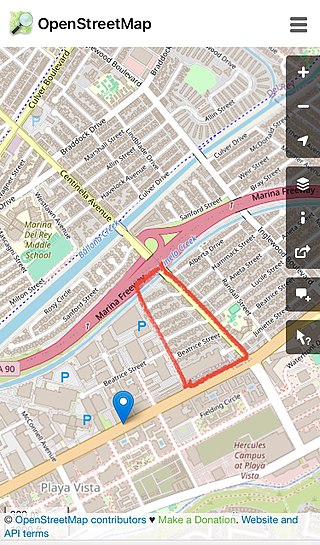
Marina del Rey is an unincorporated seaside community in Los Angeles County, California, with an eponymous harbor that is a major boating and water recreation destination of the Greater Los Angeles area. The port is North America's largest man-made small-craft harbor and is home to approximately 5,000 boats. The area is a popular tourism destination for both land and water activities such as paddle board and kayak rentals, dining cruises, and yacht charters. Land activities include bicycling on several bicycle paths, walking paths along the waterfront, and birdwatching (birding). Wildlife watching opportunities include California sea lions and harbor seals. Dolphins and whales occasionally visit the deeper waters of the harbor. This Westside locale is approximately 4 miles (6.4 km) south of Santa Monica, 4 miles (6.4 km) north of Los Angeles International Airport, and 12.5 miles (20.1 km) west-southwest of Downtown Los Angeles.
Playa del Rey is a seaside neighborhood on the westside of Los Angeles in the Santa Monica Bay region of Los Angeles County, California. It has a ZIP Code of 90293 and area codes of 310 and 424. As of 2018, the community had a population of 16,230 people.
Playa Vista is a neighborhood in the Westside area of Los Angeles, California, United States. The area was the headquarters of Hughes Aircraft Company from 1941 to 1985 and the site of the construction of the Hughes H-4 Hercules "Spruce Goose" aircraft. The area began development in 2002 as a planned community with residential, commercial, and retail components. The community attracted businesses in technology, media and entertainment and is part of Silicon Beach.
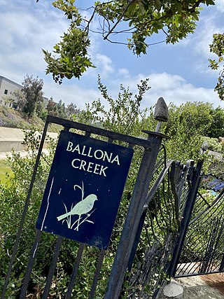
Ballona Creek is an 8.5-mile (13.7 km) channelized stream in southwestern Los Angeles County, California, United States, that was once a "year-round river lined with sycamores and willows". The urban watercourse begins in the Mid-City neighborhood of Los Angeles, flows through Culver City and Del Rey, and passes the Ballona Wetlands Ecological Preserve, the sailboat harbor Marina del Rey, and the small beachside community of Playa del Rey before draining into Santa Monica Bay. The Ballona Creek drainage basin carries water from the Santa Monica Mountains on the north, from the Baldwin Hills to the south, and as far as the Harbor Freeway (I-110) to the east.
The Third Street Promenade is a pedestrian mall esplanade, shopping, dining and entertainment complex in the downtown area of Santa Monica, California which originally opened as the Santa Monica Mall on November 8, 1965. It is considered a premier shopping and dining district on the Westside and draws crowds from all over the Greater Los Angeles area. Due to easy access to Downtown Los Angeles via the Big Blue Bus rapid transit service, E Line's terminus station and the Pacific Coast Highway-Santa Monica Freeway Interstate, the neighborhood's north-south thoroughfares connecting to Muscle Beach, Venice Canal Historic District, Marina del Rey, Ballona Wetlands and Los Angeles International Airport, and its proximity to historic U.S. Route 66, Santa Monica Pier, Palisades Park, Tongva Park, Santa Monica State Beach and the Pacific Ocean coupled with Los Angeles's mild mediterranean climate, it is also a popular tourist destination.
Ballona Wetlands Ecological Reserve is a protected area that once served as the natural estuary for neighboring Ballona Creek. The 577-acre (2.34 km2) site is located in Los Angeles County, California, just south of Marina del Rey. Ballona—the second-largest open space within the city limits of Los Angeles, behind Griffith Park—is owned by the state of California and managed by the California Department of Fish and Wildlife. The preserve is bisected generally east-west by the Ballona Creek channel and bordered by the 90 Marina freeway to the east.
The Ballona Creek Bike Path is a 6.7-mile (10.8 km) Class I bicycle path and pedestrian route in California. The bike path follows the north bank of Ballona Creek until it reaches Santa Monica Bay at the Pacific Ocean. The route is defined by, and recognized for, the dramatic contrast between the channelized waterway’s stark cement geometry and the abundant wildlife of the verdant Ballona Wetlands.
MOSE is a project intended to protect the city of Venice, Italy, and the Venetian Lagoon from flooding.
Ruth Galanter is an American politician, environmentalist and consultant with a background in urban planning. She served on the Los Angeles City Council from 1987 to 2003.
Marina Peninsula is a neighborhood in western Los Angeles, California. It is often considered a subsection of the adjacent neighborhood of Venice. Because of its name it is sometimes erroneously thought to be part of the adjacent community of Marina del Rey, California, but it was annexed to Los Angeles along with the rest of Venice in 1925.
The Culver Boulevard Median Bike Path is Class I rail trail bicycle path, walk route and linear park on Culver Boulevard in western Los Angeles County, California.
Alsace is a place name designating what was originally an interurban trolley stop, and now an approximately five-block enclave of unincorporated Los Angeles County in the Westside region, surrounded by Del Rey, just north of the Playa Vista neighborhood of Los Angeles, California, United States.
James Edwin Richards, also known as Jim Richards,, was an American citizen journalist, editor and publisher of Neighborhood News, a weekly e-mail newsletter, that reported on crime in Venice, California. Richards was murdered at his Oakwood neighborhood home, one convicted assailant was sentenced to 16 years in prison, and the anniversary of his death is honored by locals.
Port Ballona is an archaic place name for an area near the center of Santa Monica Bay in coastal Los Angeles County, where Playa Del Rey and Del Rey Lagoon are located today. Port Ballona was a planned harbor and town site from circa 1859 to 1903. The name comes from the Rancho La Ballona Mexican land grant.
Oakwood is a residential neighborhood that abuts the east side of Abbot Kinney Boulevard. It is within the larger neighborhood of Venice on the westside of Los Angeles, California. The area is noted as an "important example of African-American life in Southern California during the early 20th century". The neighborhood has alternately been referred to as "Ghost Town", "Dogtown" and the "Oakwood Pentagon". It contains one Los Angeles Historic-Cultural Monument.
The Ballona Lagoon is a soft-bottomed channel and 16-acre (65,000 m2) tidal marsh in the Marina Peninsula neighborhood of Los Angeles that feeds the Venice Canals with water from the Pacific Ocean via a tide gate.
Del Rey Lagoon Park is a 14-acre (57,000 m2) municipal park in the Playa Del Rey neighborhood of Los Angeles, United States, with a lagoon that is part of the greater Ballona Creek watershed.
Oxford Basin is a 10.7-acre (43,000 m2) constructed wetland and wildlife conservation area in the northwest corner of Marina del Rey, California, located between Washington Boulevard and Admiralty Way.
The Mesmer family of California was a wealthy family of early Los Angeles settlers who contributed to the development of the city between the rancho era and the explosive growth of the post-WWII era.
This page is based on this Wikipedia article Text is available under the CC BY-SA 4.0 license; additional terms may apply. Images, videos and audio are available under their respective licenses.