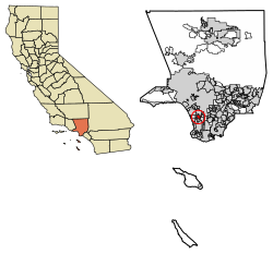
Hawthorne, California | |
---|---|
Motto: "City of Good Neighbors" | |
Coordinates: 33°55′2″N118°20′55″W / 33.91722°N 118.34861°W | |
Country | United States |
State | California |
County | Los Angeles |
Incorporated | July 12, 1922 [1] |
Named for | Nathaniel Hawthorne |
Government | |
• Type | Council-Manager |
• Mayor | Alex Vargas |
• City Manager | Vontray (Von) Norris |
Area | |
• Total | 6.09 sq mi (15.78 km2) |
• Land | 6.08 sq mi (15.75 km2) |
• Water | 0.01 sq mi (0.03 km2) 0.18% |
Elevation | 72 ft (22 m) |
Population | |
• Total | 88,083 |
• Rank | 99th in California |
• Density | 14,000/sq mi (5,600/km2) |
Time zone | UTC−8 (Pacific Time Zone) |
• Summer (DST) | UTC−7 (PDT) |
ZIP Codes | 90250 and 90251 [7] |
Area codes | 310/424, [8] 213/323 |
FIPS code | 06-32548 |
GNIS feature IDs | 1652717, 2410720 |
Website | cityofhawthorne.org |
Hawthorne is a city in the Los Angeles metropolitan area, located in southwestern Los Angeles County, California. It is part of a seventeen-city region commonly called the South Bay. As of the 2020 US census, Hawthorne had a population of 88,083. [6]
Hawthorne was once part of the Rancho Sausal Redondo (Round Willow-grove Ranch) of the 22,458-acre (91 km2) Mexican land grant in present-day Los Angeles County, California given in 1837 to Antonio Ygnacio Ávila by Juan Alvarado the Mexican Governments Governor of Alta California. [9] Rancho Sausal Redondo covered the area that now includes Playa Del Rey, El Segundo, Manhattan Beach, Lawndale, Hermosa Beach, Inglewood, Hawthorne, and Redondo Beach. [10] [11]
Hawthorne was founded in 1905 as the "Hawthorne Improvement Company" by real estate developers B.L. Harding and H.D. Lombard. Harding's daughter shared her birthday—July 4, American Independence Day—with New England author Nathaniel Hawthorne, and a decision was made to name the small village after him. [12]
Hawthorne was once a "whites only" settlement, commonly called a sundown town. [13] During the 1930s, signs warned African-Americans to be out of Hawthorne by sundown. [14]
To the north of Hawthorne is the unincorporated community of Lennox and the city of Inglewood. To the east is the unincorporated community of Athens and the city of Gardena. To the south is the unincorporated community of El Camino Village, and the cities of Lawndale and Redondo Beach. Manhattan Beach is at the southwest corner of Hawthorne. To the west is the city of El Segundo, and the Los Angeles neighborhood of Westchester is to the northwest of Hawthorne. Hawthorne surrounds the unincorporated community of Del Aire on three sides. It also shares a small border on the northeast along Imperial Highway with the unincorporated community of Westmont.
The Century Freeway (Glenn Anderson Freeway, I-105) runs along the northern boundary of Hawthorne, with the C Line light rail line running down the center of the Century Freeway. The San Diego Freeway (I-405) runs along the western boundary of Hawthorne. Major east–west streets in Hawthorne include Rosecrans Avenue, El Segundo Boulevard, and Imperial Highway. Major north–south streets include Aviation Boulevard, Inglewood Avenue, Hawthorne Boulevard, Prairie Avenue, Crenshaw Boulevard, and Van Ness Avenue.
Hawthorne is five miles (8 km) from the Los Angeles International Airport. [15]
Hawthorne comprises ZIP codes 90250 and 90251. It is in the 310 area code, except for a small portion of northeastern Hawthorne, which is located in the 323 area code.
Hawthorne, California | ||||||||||||||||||||||||||||||||||||||||||||||||||||||||||||
---|---|---|---|---|---|---|---|---|---|---|---|---|---|---|---|---|---|---|---|---|---|---|---|---|---|---|---|---|---|---|---|---|---|---|---|---|---|---|---|---|---|---|---|---|---|---|---|---|---|---|---|---|---|---|---|---|---|---|---|---|
Climate chart (explanation) | ||||||||||||||||||||||||||||||||||||||||||||||||||||||||||||
| ||||||||||||||||||||||||||||||||||||||||||||||||||||||||||||
|
Hawthorne, like the rest of the Los Angeles basin, has a Mediterranean climate:
Hawthorne has a Mediterranean climate or dry-summer subtropical (Köppen climate classification Csb on the coast, Csa inland), enjoying plenty of sunshine throughout the year, with an average of 263 sunshine days and only 35 days with measurable precipitation annually. [16]
Census | Pop. | Note | %± |
---|---|---|---|
1930 | 6,596 | — | |
1940 | 8,263 | 25.3% | |
1950 | 16,316 | 97.5% | |
1960 | 33,035 | 102.5% | |
1970 | 53,304 | 61.4% | |
1980 | 56,437 | 5.9% | |
1990 | 71,349 | 26.4% | |
2000 | 84,112 | 17.9% | |
2010 | 84,293 | 0.2% | |
2020 | 88,083 | 4.5% | |
U.S. Decennial Census [17] 1860–1870 [18] [19] 1880-1890 [20] 1900 [21] 1910 [22] 1920 [23] 1930 [24] 1940 [25] 1950 [26] 1960 [27] 1970 [28] 1980 [29] 1990 [30] 2000 [31] 2010 [32] 2020 [33] |
Hawthorne first appeared as a city in the 1930 U.S. Census. [24]
Race / Ethnicity (NH = Non-Hispanic) | Pop 2000 [34] | Pop 2010 [35] | Pop 2020 [33] | % 2000 | % 2010 | % 2020 |
---|---|---|---|---|---|---|
White alone (NH) | 10,397 | 8,642 | 9,147 | 13.00% | 10.25% | 10.38% |
Black or African American alone (NH) | 27,208 | 22,579 | 20,763 | 32.35% | 26.79% | 23.57% |
Native American or Alaska Native alone (NH) | 199 | 172 | 128 | 0.24% | 0.20% | 0.15% |
Asian alone (NH) | 5,567 | 5,492 | 6,552 | 6.62% | 6.52% | 7.44% |
Native Hawaiian or Pacific Islander alone (NH) | 685 | 919 | 683 | 0.81% | 1.09% | 0.78% |
Other race alone (NH) | 256 | 397 | 773 | 0.30% | 0.47% | 0.88% |
Mixed race or Multiracial (NH) | 2,033 | 1,520 | 2,727 | 2.42% | 1.80% | 3.10% |
Hispanic or Latino (any race) | 37,227 | 44,572 | 47,310 | 44.26% | 52.88% | 53.71% |
Total | 84,112 | 84,293 | 88,083 | 100.00% | 100.00% | 100.00% |
At the 2010 census Hawthorne had a population of 84,293. The population density was 13,835.7 inhabitants per square mile (5,342.0/km2). The racial makeup of Hawthorne was 27,678 (32.8%) White (10.3% Non-Hispanic White), [6] 23,385 (27.7%) African American, 565 (0.7%) Native American, 5,642 (6.7%) Asian, 974 (1.2%) Pacific Islander, 22,127 (26.3%) from other races, and 3,922 (4.7%) from two or more races. There were 44,572 people of Hispanic or Latino origin, of any race (52.9%). [36]
The census reported that 83,754 people (99.4% of the population) lived in households, 208 (0.2%) lived in non-institutionalized group quarters, and 331 (0.4%) were institutionalized.
There were 28,486 households, 12,330 (43.3%) had children under the age of 18 living in them, 10,833 (38.0%) were opposite-sex married couples living together, 6,369 (22.4%) had a female householder with no husband present, 2,357 (8.3%) had a male householder with no wife present. There were 2,309 (8.1%) unmarried opposite-sex partnerships, and 191 (0.7%) same-sex married couples or partnerships. Of the households, 7,125 (25.0%) were one person and 1,430 (5.0%) had someone living alone who was 65 or older. The average household size was 2.94. There were 19,559 families (68.7% of households); the average family size was 3.54.
The age distribution was 23,157 people (27.5%) under the age of 18, 9,487 people (11.3%) aged 18 to 24, 27,035 people (32.1%) aged 25 to 44, 18,395 people (21.8%) aged 45 to 64, and 6,219 people (7.4%) who were 65 or older. The median age was 31.5 years. For every 100 females, there were 93.2 males. For every 100 females age 18 and over, there were 89.6 males.
There were 29,869 housing units at an average density of 4,902.7 per square mile, of the occupied units 7,623 (26.8%) were owner-occupied and 20,863 (73.2%) were rented. The homeowner vacancy rate was 1.5%; the rental vacancy rate was 4.6%. 25,869 people (30.7% of the population) lived in owner-occupied housing units and 57,885 people (68.7%) lived in rental housing units.
During 2009–2013, Hawthorne had a median household income of $44,649, with 19.2% of the population living below the federal poverty line. [6]
As of the census [37] of 2000, there were 84,112 people in 28,536 households, including 19,775 families, in the city. The population density was 13,879.4 inhabitants per square mile (5,358.9/km2). There were 29,629 housing units at an average density of 4,889.1 per square mile (1,887.7/km2). The racial makeup of the city was 29.3% White, 39.0% Black or African American, 0.8% Native American, 7.7% Asian, 0.9% Pacific Islander, 24.2% from other races, and 5.2% from two or more races. 44.3% of the population were Hispanic or Latino of any race.
There were 28,536 households, 43.7% included children under the age of 18, 38.6% were married couples living together, 23.5% had a female householder with no husband present, and 30.7% were non-families. Of all households 24.5% were one person and 4.5% were one person aged 65 or older. The average household size was 2.93 and the average family size was 3.50.
The age distribution was 31.7% under the age of 18, 11.3% from 18 to 24, 34.9% from 25 to 44, 16.1% from 45 to 64, and 6.1% 65 or older. The median age was 29 years. For every 100 females, there were 92.6 males. For every 100 females age 18 and over, there were 87.3 males.
The median household income was $31,887 and the median family income was $35,149. Males had a median income of $29,481 versus $27,427 for females. The per capita income for the city was $15,022. About 18.4% of families and 20.3% of the population were below the poverty line, including 25.6% of those under age 18 and 9.0% of those age 65 or over.
Mexican (27.1%) and Filipino (2.6%) are the most common ancestries in the city. Mexico (45.1%) and Guatemala (9.3%) are the most common foreign places of birth in the city. [38]
In 2022, Los Angeles Homeless Services Authority's Greater Los Angeles Homeless Count counted 173 homeless individuals in Hawthorne. [39]
Year | Pop. | ±% |
---|---|---|
2016 | 106 | — |
2017 | 95 | −10.4% |
2018 | 149 | +56.8% |
2019 | 108 | −27.5% |
2020 | 208 | +92.6% |
2022 | 173 | −16.8% |
Source: Greater Los Angeles Homeless Count Los Angeles Homeless Services Authority |
This section needs additional citations for verification .(January 2015) |
As of 2022 the city is known as a center for the space industry and hosts numerous space related private companies, industries and startups. [40] The relatively large number of aerospace engineers and technicians, history of established aerospace companies, and the presence of SpaceX has facilitated the development of space engineering industry cluster in the city. [40] According to the city's 2021 Comprehensive Annual Financial Report, [41] the top employers in the city are:
# | Employer | # of Employees |
---|---|---|
1 | SpaceX | 6,094 |
2 | Amazon Fulfillment Center | 1,500 |
3 | Hawthorne School District | 900 |
4 | Wiseburn Unified School District | 394 |
5 | City of Hawthorne | 360 |
6 | Home Depot | 340 |
7 | OSI Systems | 280 |
8 | Expeditors | 260 |
9 | Teledyne Relays | 253 |
10 | Target | 250 |
Besides the current top employers, the following businesses are currently located in Hawthorne:
Previously in Hawthorne:
Hawthorne has an elected city council composed of a mayor elected every four years and four city council members elected on four year terms.
OFFICE | OFFICE HOLDER | TERM ENDS |
---|---|---|
Mayor | Alex Vargas | December 2024 |
Mayor Pro Tem | Angie Reyes-English | December 2024 |
Councilmember | L. David Patterson | December 2024 |
Councilmember | Alex Monteiro | December 2026 |
Councilmember | Katrina Manning | December 2026 |
OFFICE | OFFICE HOLDER | TERM ENDS |
---|---|---|
City Treasurer | Marie Poindexter-Hornback | December 2026 |
City Clerk | Dayna Williams-Hunter | December 2026 |
According to the city's most recent[ when? ] "Comprehensive Annual Financial Report," its various funds had $126.1 million in revenues, $113.2 million in expenditures, $220.2 million in total assets, $152.7 million in total liabilities, and $29.6 million in cash and investments. [48] The city manager is Vontray Norris. [3]
In the California State Legislature, Hawthorne is in the 35th Senate District , represented by Democrat Laura Richardson, and in the 62nd Assembly District , represented by Democrat Jose Solache. [49]
In the United States House of Representatives, Hawthorne is in California's 43rd congressional district , represented by Democrat Maxine Waters. [50]
Hawthorne is served by multiple school districts. [51] Schools that include portions of Hawthorne include: [52]
In addition Los Angeles County Office of Education operates Southwest Day (5th-12th grade).
Hawthorne Math and Science Academy is a charter high school in Hawthorne associated with the Hawthorne School District. [56]
The Hawthorne Press Tribune is the community newspaper for the City of Hawthorne. [57]
The Los Angeles County Department of Health Services operates the Curtis Tucker Health Center in Inglewood, serving Hawthorne. [58]
The United States Postal Service Hawthorne Post Office is located at 12700 Inglewood Avenue. [59]
The South Bay is a region of the Los Angeles metropolitan area, located in the southwest corner of Los Angeles County. The name stems from its geographic location stretching along the southern shore of Santa Monica Bay. The South Bay contains sixteen cities plus portions of the City of Los Angeles and unincorporated portions of the county. The area is bounded by the Pacific Ocean on the south and west and generally by the City of Los Angeles on the north and east.
Alondra Park, also known as El Camino Village, is an unincorporated community and census designated place (CDP) in the South Bay region of Los Angeles County, California, United States. It is the unincorporated area north of Alondra Community Regional Park and El Camino College. It is east of Lawndale, south of Hawthorne, west of Gardena, and north of Torrance. Manhattan Beach Boulevard and Crenshaw Boulevard are the two major cross streets in the area. The population was 8,569 at the 2020 census, down from 8,592 at the 2010 census. There is an official Alondra Park Post Office of the U.S. Postal Service in nearby Gardena, California. Urbanized cement-lined Dominguez Creek bisects a portion of Alondra Park.
Del Aire is a census-designated place (CDP) in the inland South Bay, Los Angeles County, California, United States, between El Segundo and Hawthorne. The population was 10,001 at the 2010 census, up from 9,012 at the 2000 census.
El Segundo is a city in Los Angeles County, California, United States. Located on Santa Monica Bay, it was incorporated on January 18, 1917, and is part of the South Bay Cities Council of Governments. The population was 16,731 as of the 2020 census, a 0.5% increase from 16,654 in the 2010 census. A significant center of the oil and aerospace industries in Southern California, roughly three quarters of the city's land is dedicated exclusively to industrial and commercial uses, including a Chevron oil refinery which alone takes up more than a quarter of the entire city.
Gardena is a city located in the South Bay region of Los Angeles County, California, United States. The population was 58,829 at the 2010 census, up from 57,746 at the 2000 census. Until 2014, the U.S. census cited the City of Gardena as the place with the highest percentage of Japanese Americans in California. Gardena's Japanese American population contributes to the South Bay region of Los Angeles being home to the highest density of Japanese companies within the mainland United States.
Hermosa Beach is a beachfront city in Los Angeles County in the U.S. state of California, United States. Its population was 19,728 at the 2020 U.S. Census. The city is located in the South Bay region of the Greater Los Angeles area; it is one of the three Beach Cities. Hermosa Beach is bordered by the other two, Manhattan Beach to the north and Redondo Beach to the south and east.
Inglewood is a city in southwestern Los Angeles County, California, United States, in the Greater Los Angeles metropolitan area. As of the 2020 U.S. census, the city had a population of 107,762. It is in the South Bay region of Los Angeles County, near Los Angeles International Airport. The Inglewood area was developed following the opening of the Venice–Inglewood railway in 1887 and incorporated as a city on February 14, 1908. The Inglewood Oil Field is the largest urban oil field in the US.
Ladera Heights is a community and unincorporated area in Los Angeles County, California. The population was 6,634 at the 2020 census. Culver City lies to its west, the Baldwin Hills neighborhood to its north, the View Park-Windsor Hills community to its east, the Westchester neighborhood to its south and southwest and the city of Inglewood to its southeast. With an average household income of $132,824, Ladera Heights ranks third amongst the ten wealthiest majority-Black communities in the United States.
Lawndale is a city in Los Angeles County, California, United States. The population was 32,769 at the 2010 census, up from 31,712 according to the 2000 census. The city is in the South Bay region of the Greater Los Angeles Area.
Lennox is a census-designated place (CDP) in the South Bay region of Los Angeles County, California, United States. The population was 22,753 at the 2010 census, down from 22,950 at the 2000 census.
Manhattan Beach is a city in southwestern Los Angeles County, California, United States, on the Pacific coast south of El Segundo, west of Hawthorne and Redondo Beach, and north of Hermosa Beach. As of the 2020 census, the population was 35,506.
Rancho Palos Verdes is a coastal city located in south Los Angeles County, California. Incorporated on September 7, 1973, the city has a population of 42,287 as reported in the 2020 United States Census. Rancho Palos Verdes sits atop the bluffs of the Palos Verdes Peninsula, neighboring three other cities in the Palos Verdes Hills, namely Palos Verdes Estates, Rolling Hills, and Rolling Hills Estates. It is known for its extensive nature preserves and hiking trails, and its school district, as well as high property values.
Redondo Beach is a coastal city in Los Angeles County, California, United States, located in the South Bay region of the Greater Los Angeles area. It is one of three adjacent beach cities along the southern portion of Santa Monica Bay. The population was 71,576 at the 2020 census, up from 66,748 in 2010.
Torrance is a coastal city in the Los Angeles metropolitan area located in southwestern Los Angeles County, California, United States. The city is part of what is known as the South Bay region of the metropolitan area. A small section of the city, 1.5 miles (2.4 km), abuts the Pacific Ocean. Torrance has a moderate year-round climate with average rainfall of 12 inches (300 mm) per year. Torrance was incorporated in 1921, and at the 2020 census had a population of 147,067 residents. Torrance has a beachfront and has 30 parks located around the city. It is also the birthplace of the American Youth Soccer Organization (AYSO).
West Athens is a census-designated place (CDP) in Los Angeles County, California. The population was 9,393 at the 2020 census. It is an unincorporated community within the 2nd Supervisorial District of Los Angeles County. West Athens is served by the Los Angeles County Sheriff's Department, operating out of the South Los Angeles Station. The approximate boundaries for West Athens are: 87th Street to the north, Vermont Avenue to the east, El Segundo Boulevard to the south, and approximately Western Avenue to Van Ness Avenue to the west. West Athens is predominantly residential, with commercial uses along its main corridors. Los Angeles Southwest Community College lies within the West Athens neighborhood and city limits.
State Route 107 is a state highway in the U.S. state of California that forms part of Hawthorne Boulevard in the Los Angeles Area from State Route 1 in Torrance north to Redondo Beach Boulevard at the Redondo Beach–Lawndale border.
California's 43rd congressional district is a congressional district in the U.S. state of California that is currently represented by Democrat Maxine Waters. The district is centered in the southern part of Los Angeles County, and includes portions of the cities of Los Angeles and Torrance. It includes the entirety of the cities of Hawthorne, Lawndale, Gardena, Inglewood, and Lomita. From 2003 until 2013, the 43rd district was based in San Bernardino County. The Hispanic-majority district encompassed the southwestern part of the county, and included San Bernardino and Rialto.
Centinela Valley Union High School District, (CVUHSD) is a public union high school district located in southern California that serves about 6,800 students in grades 9–12 from all of Lawndale and Lennox, most of Hawthorne and Alondra Park, and a small portion of Inglewood. The district's three associated elementary feeder school districts are Hawthorne School District, Lawndale Elementary School District, and Lennox School District. Previously Wiseburn Unified School District, now a unified district, fed into CVUSD. The Centinela Valley district also offers adult education classes.
Lawndale Elementary School District (LESD) is a school district headquartered in Lawndale, California, United States.
Rancho Sausal Redondo was a 22,458-acre (91 km2) Mexican land grant in present day Los Angeles County, California given in 1837 to Antonio Ygnacio Ávila by Juan Alvarado Governor of Alta California. Rancho Sausal Redondo covered the area that now includes Playa Del Rey, El Segundo, Manhattan Beach, Lawndale, Hermosa Beach, Inglewood, Hawthorne, and Redondo Beach.