The San Gabriel Valley was first inhabited by the Tongva whose traditional lands extended throughout the area of modern-day greater Los Angeles.[7] While Juan Rodríguez Cabrillo first discovered California for Spain in 1542, Spanish colonization did not begin until 1769 with the Portolá expedition.[8] In 1771, the entire valley, including present-day Monrovia, came under the domain of the newly established Mission San Gabriel, initially located along the San Gabriel River near the southern edge of the valley. The mission utilized the lower portion of the valley for raising cattle and farming while the uplands, including Monrovia, remained untouched.[9]
Following Mexico's independence from Spain and the Mexican Congress's enactment of secularization laws in 1833, the government of Alta California began the process of secularizing missions and dispersing their property.[10] On April 16, 1841, Hugo Reid, a naturalized Mexican citizen from Great Britain, was provisionally granted ownership of Rancho Santa Anita, which included most of present-day Monrovia to the west of Norumbega Drive, and received a fee simple title to the land in 1845.[11] Rancho Santa Anita then changed hands several times before Lucky Baldwin acquired it on April 8, 1875.[12] In 1884, William N. Monroe purchased a 120-acre plot from Baldwin in present-day Monrovia that encompassed both sides of White Oak Avenue (now Foothill Boulevard). Monroe acquired an additional 90 acres in 1885.[13]
In 1886, Monroe partnered with Edward F. Spence, John D. Bicknell, and James F. Crank to form a 120-acre town centered around Myrtle Avenue and present-day Colorado Boulevard; the first sale of townsite lots began on May 17, 1886.[14][15] Within nineteen months, several banks, hotels, churches, and schools were built.[16] In 1887, Monrovia reached a population of 500 and was incorporated on December 15, making it the fourth incorporated city in Los Angeles County after Los Angeles, Santa Monica, and Pasadena.[15][17] Monrovia was connected to Los Angeles by rail in 1888 through the efforts of the San Gabriel Valley Rapid Transit Railroad Company. The Los Angeles Terminal Railway briefly assumed control over the rail line in 1892 before selling the railway to Southern Pacific in 1893.[18]
Pacific Electric in Monrovia, 1903
In 1903, the Pacific Electric railway opened a line to Monrovia. The expansion of this interurban railway, which served the greater Los Angeles area, allowed residents to visit the beach for the day, commute to downtown Los Angeles, and travel the region. It also contributed to Monrovia's growth with the population nearly tripling over a decade to 3,576 in 1910. After construction stagnated during World War I, it increased in the post-war years with a record number of building permits being issued in 1923. From 1920 to 1930, Monrovia's population increased from 5,480 to 10,890.[19]
Monrovia, 1914 (Myrtle Avenue, looking north)
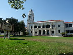
In 1905, Carnegie funds became available and, with the help of the Board of Trade (forerunner to the Chamber of Commerce) and the Monrovia Women's Club, a bond issue was passed to purchase the Granite Bank Building to be used as a city hall, and to acquire property for a public park. The Granite Building has served as the city hall, fire and police department facilities since 1961 and the fire department since 1974. In 1956, the old Carnegie library building was torn down and a new library was constructed. In March 2007, a new library was voted on by the people of Monrovia. It won with 70% yes votes. The library now has 190,000 books, a heritage room for historical documents, and areas for children, teens, and adults.[20]
In 1930, the Monrovia Airport, also known as the Foothill Flying Club, was commercially established. The small airstrip claimed to have had 12,000 paying customers use the airfield in 1932 and on May 19, 1938, the first airmail flight took off from Monrovia Airport. Ownership of the airport changed hands several times while it was in operation; pilots remembered it as "the friendliest little airport in the country." Apart from usage by Riley Brothers, TWA Captain and former airshow pilot Kalman Irwin, and Pancho Barnes, the airfield is well known for its use as a movie-filming location. The first movie filmed at the Monrovia Airport was The Fighting Pilot. Other films shot at the airfield include 20,000 Men a Year, The Great Plane Robbery, and most notably, The Big Noise, featuring Laurel and Hardy. The 35-acre airfield, used as a runway as well as an airplane repair and storage service, was forced to close in 1953 after being sold to Consolidated Engineering Corporation for redevelopment as a result of increased land values.[21]
Monrovia was the home to the precursor to McDonald's. In 1937, Patrick McDonald opened a food stand on Huntington Drive (Route 66) near the old Monrovia Airport called "The Airdrome" (hamburgers were ten cents, and all-you-can-drink orange juice was five cents); it remained there until 1940, when he and his two sons, Maurice and Richard, moved the building 40 miles (64km) east to San Bernardino to the corner of West 14th Street and 1398 North E Street, renaming it "McDonald's".
According to the United States Census Bureau, the city has an area of 35.5 square kilometers (13.7mi2). 13.6 square miles (35km2) of it is land and 0.1 square miles (0.26km2) of it (0.79%) is water.[22]
Wildlife is abundant in the adjacent San Gabriel Mountains, including mammals like black bears, bobcats, coyotes, gray foxes, mountain lions, and mule deer, many of which roam area neighborhoods and visit backyards.[23] In 2024, a mother black bear and her young cubs began regularly visiting a home in Monrovia situated close to the mountains to cool-off and play in the property's swimming pool. By May, the bear family had become such regular visitors, with the homeowners posting numerous videos online, that it was reported on by multiple local, national and international news outlets, including Sky News Australia.[24]
Monrovia city, California – Racial and ethnic composition Note: the US Census treats Hispanic/Latino as an ethnic category. This table excludes Latinos from the racial categories and assigns them to a separate category. Hispanics/Latinos may be of any race.
The census reported that 99.4% of the population lived in households, 0.4% lived in non-institutionalized group quarters, and 0.2% were institutionalized.[44]
There were 14,556 households, out of which 30.5% included children under the age of 18, 45.6% were married-couple households, 6.6% were cohabiting couple households, 30.2% had a female householder with no partner present, and 17.6% had a male householder with no partner present. 26.4% of households were one person, and 10.6% were one person aged 65 or older. The average household size was 2.59.[44] There were 9,635 families (66.2% of all households).[45]
The age distribution was 19.4% under the age of 18, 7.8% aged 18 to 24, 29.1% aged 25 to 44, 27.9% aged 45 to 64, and 15.8% who were 65years of age or older. The median age was 40.5years. For every 100 females, there were 91.3 males.[44]
There were 15,241 housing units at an average density of 1,118.0 unitsper square mile (431.7 units/km2), of which 14,556 (95.5%) were occupied. Of these, 46.4% were owner-occupied, and 53.6% were occupied by renters.[44]
In 2023, the US Census Bureau estimated that the median household income was $97,083, and the per capita income was $47,622. About 7.0% of families and 10.5% of the population were below the poverty line.[46]
2010
The 2010 United States census[47] reported that Monrovia had a population of 36,590. The population density was 2,668.1 inhabitants per square mile (1,030.2/km2). The racial makeup of Monrovia was 21,932 (59.9%) White (41.1% Non-Hispanic White),[48] 4,107 (11.2%) Asian, 2,500 (6.8%) African American, 279 (0.8%) Native American, 76 (0.2%) Pacific Islander, 5,818 (15.9%) from other races, and 1,878 (5.1%) from two or more races. Hispanic or Latino of any race were 14,043 persons (38.4%).
The census reported that 36,434 people (99.6% of the population) lived in households, 61 (0.2%) lived in non-institutionalized group quarters, and 95 (0.3%) were institutionalized.
There were 13,762 households, out of which 4,725 (34.3%) had children under the age of 18 living in them, 6,295 (45.7%) were opposite-sex married couples living together, 2,073 (15.1%) had a female householder with no husband present, 778 (5.7%) had a male householder with no wife present. There were 793 (5.8%) unmarried opposite-sex partnerships, and 131 (1.0%) same-sex married couples or partnerships. 3,649 households (26.5%) were made up of individuals, and 1,276 (9.3%) had someone living alone who was 65 years of age or older. The average household size was 2.65. There were 9,146 families (66.5% of all households); the average family size was 3.24.
The population was spread out, with 8,514 people (23.3%) under the age of 18, 3,084 people (8.4%) aged 18 to 24, 10,733 people (29.3%) aged 25 to 44, 10,018 people (27.4%) aged 45 to 64, and 4,241 people (11.6%) who were 65 years of age or older. The median age was 37.9 years. For every 100 females, there were 91.6 males. For every 100 females age 18 and over, there were 87.0 males.
There were 14,473 housing units at an average density of 1,055.4 unitsper square mile (407.5 units/km2), of which 6,809 (49.5%) were owner-occupied, and 6,953 (50.5%) were occupied by renters. The homeowner vacancy rate was 1.3%; the rental vacancy rate was 4.9%. 18,478 people (50.5% of the population) lived in owner-occupied housing units and 17,956 people (49.1%) lived in rental housing units.
According to the 2010 United States census, Monrovia had a median household income of $71,768, with 9.8% of the population living below the federal poverty line.[48]
Mapping L.A.
Mapping L.A. reported that in 2000, Mexican (27.0%) and German (7.9%) were the most common ancestries. Mexico (48.1%) and the Philippines (8.6%) were the most common foreign places of birth.[49]
The Monrovia Unified School District operates 12 public schools, consisting of 5 elementary schools, 2 middle schools, 1 alternative school, 1 independent study school, and 1 adult school:
Newspapers with offices in Monrovia include the San Gabriel Valley Tribune, which publishes community news, and Monrovia Weekly, a community newspaper. Public access television is provided by KGEM-TV, which is available primarily to cable viewers, with some content online.[55]
Infrastructure
Transportation
Monrovia Trolley Bus in front of the Krikorian Theater (2005)
In 2016, Metro opened a new at-grade light rail station in Monrovia, Monrovia station, at the intersection of Myrtle Avenue and Duarte Road. It is served by the Metro A Line.[56] It is at the location of the former Santa Fe Depot, which still stands.[57]
↑Lloyd, Jonathan; Arabian, Nyree (May 7, 2024). "Watch: Bear and cubs enjoy pool day in Monrovia". NBC Los Angeles. Retrieved May 12, 2024. It's not the adult bear's first visit to the neighborhood. She visits so frequently that residents have named her Maddie. "We see her often," said resident Brian Gordon. "I think one of the neighbors got 400,000 Likes on Instagram. She's swinging on a swing. She was at an open house in somebody's hot tub down the street. So, we see her quite a bit. She's even crashed our pool parties. If we're barbecuing, she'll show up and scare everyone."
↑Shreve, Jr., Ivan G. (September 30, 2019). "Happy Birthday, Kenny Baker!". Radio Spirits. Archived from the original on August 7, 2025. Retrieved November 4, 2025. From 1935 to 1939, Kenneth Laurence Baker—born in Monrovia, California on this date in 1912—was welcomed into millions of homes as the popular tenor vocalist on radio's The Jack Benny Program.
↑Bach, John. "Former UC and NBA star returns to UC to complete his degree". UC Magazine. University Relations, University of Cincinnati. Archived from the original on April 21, 2025. Retrieved November 4, 2025. Blount grew up the second oldest of five children raised by their great-grandmother, Beatrice Kelly, in a two-bedroom home in Monrovia, Calif.
↑Chawkins, Steve (April 26, 2015). "Don Mankiewicz dies at 93; novelist and Oscar-nominated screenwriter". Los Angeles Times. Archived from the original on November 27, 2024. Don M. Mankiewicz, a novelist and Oscar-nominated screenwriter who grew up in a fabled Hollywood family and went on to create TV's "Ironside" and "Marcus Welby, M.D." has died at his home in Monrovia.
This page is based on this Wikipedia article Text is available under the CC BY-SA 4.0 license; additional terms may apply. Images, videos and audio are available under their respective licenses.