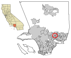
Mayflower Village, California | |
---|---|
Coordinates: 34°7′4″N118°0′34″W / 34.11778°N 118.00944°W | |
Country | United States |
State | California |
County | Los Angeles |
Area | |
• Total | 0.687 sq mi (1.779 km2) |
• Land | 0.687 sq mi (1.779 km2) |
• Water | 0 sq mi (0 km2) 0% |
Elevation | 367 ft (112 m) |
Population | |
• Total | 5,402 |
• Density | 7,900/sq mi (3,000/km2) |
Time zone | UTC-8 (PST) |
• Summer (DST) | UTC-7 (PDT) |
ZIP code | 91006 & 91016 |
Area code | 626 |
FIPS code | 06-46436 |
GNIS feature ID | 1867040 |
Mayflower Village is a census-designated place (CDP) in the San Gabriel Valley, in Los Angeles County, California, United States. The population was 5,515 at the 2010 census, up from 5,081 at the 2000 census. The ZIP Codes serving the community are 91006, which is served by Arcadia and 91016, which is served by Monrovia. [3]
According to the United States Census Bureau, the CDP has a total area of 0.7 square miles (1.8 km2), all land.
Census | Pop. | Note | %± |
---|---|---|---|
1980 | 5,018 | — | |
1990 | 4,978 | −0.8% | |
2000 | 5,081 | 2.1% | |
2010 | 5,515 | 8.5% | |
2020 | 5,402 | −2.0% |
At the 2010 census Mayflower Village had a population of 5,515. The population density was 8,030.2 inhabitants per square mile (3,100.5/km2). The racial makeup of Mayflower Village was 2,929 (53.1%) White (37.1% Non-Hispanic White), [4] 83 (1.5%) African American, 28 (0.5%) Native American, 1,734 (31.4%) Asian, 4 (0.1%) Pacific Islander, 491 (8.9%) from other races, and 246 (4.5%) from two or more races. Hispanic or Latino of any race were 1,521 persons (27.6%). [5]
The census reported that 5,511 people (99.9% of the population) lived in households, 4 (0.1%) lived in non-institutionalized group quarters, and no one was institutionalized.
There were 1,905 households, 656 (34.4%) had children under the age of 18 living in them, 1,078 (56.6%) were opposite-sex married couples living together, 249 (13.1%) had a female householder with no husband present, 98 (5.1%) had a male householder with no wife present. There were 81 (4.3%) unmarried opposite-sex partnerships, and 9 (0.5%) same-sex married couples or partnerships. 385 households (20.2%) were one person and 177 (9.3%) had someone living alone who was 65 or older. The average household size was 2.89. There were 1,425 families (74.8% of households); the average family size was 3.34.
The age distribution was 1,197 people (21.7%) under the age of 18, 435 people (7.9%) aged 18 to 24, 1,433 people (26.0%) aged 25 to 44, 1,692 people (30.7%) aged 45 to 64, and 758 people (13.7%) who were 65 or older. The median age was 41.1 years. For every 100 females, there were 92.5 males. For every 100 females age 18 and over, there were 89.7 males.
There were 1,975 housing units at an average density of 2,875.7 per square mile, of the occupied units 1,559 (81.8%) were owner-occupied and 346 (18.2%) were rented. The homeowner vacancy rate was 1.0%; the rental vacancy rate was 6.0%. 4,464 people (80.9% of the population) lived in owner-occupied housing units and 1,047 people (19.0%) lived in rental housing units.
According to the 2010 United States Census, Mayflower Village had a median household income of $76,461, with 5.6% of the population living below the federal poverty line. [4]
According to the census [6] of 2000, there were 5,081 people, 1,825 households, and 1,315 families in the CDP. The population density was 7,652.3 inhabitants per square mile (2,954.6/km2). There were 1,915 housing units at an average density of 2,884.1 per square mile (1,113.6/km2). The racial makeup of the CDP was 66.38% White, 1.18% African American, 0.69% Native American, 16.55% Asian, 0.18% Pacific Islander, 10.35% from other races, and 4.66% from two or more races. Hispanic or Latino of any race were 26.61% of the population.
Of the 1,825 households 32.9% had children under the age of 18 living with them, 56.8% were married couples living together, 10.6% had a female householder with no husband present, and 27.9% were non-families. 22.8% of households were one person and 10.9% were one person aged 65 or older. The average household size was 2.78 and the average family size was 3.30.
The age distribution was 24.7% under the age of 18, 6.6% from 18 to 24, 30.3% from 25 to 44, 23.8% from 45 to 64, and 14.6% 65 or older. The median age was 38 years. For every 100 females, there were 93.9 males. For every 100 females age 18 and over, there were 90.5 males.
The median household income was $55,547 and the median family income was $63,814. Males had a median income of $40,783 versus $35,634 for females. The per capita income for the CDP was $21,790. About 6.7% of families and 7.0% of the population were below the poverty line, including 8.1% of those under age 18 and 8.7% of those age 65 or over.
In the California State Senate, Mayflower Village is split between the 22nd Senate District , represented by Democrat Susan Rubio, and the 25th Senate District , represented by Democrat Anthony Portantino. In the California State Assembly, it is split between the 48th Assembly District , represented by Democrat Blanca Rubio, and the 49th Assembly District , represented by Democrat Mike Fong. [7]
In the United States House of Representatives, Mayflower Village is split between California's 27th congressional district , represented by Republican Mike Garcia, and California's 32nd congressional district , represented by Democrat Brad Sherman. [8]
Bayview is a census-designated place (CDP) located adjacent to the City of Eureka in Humboldt County, California, United States. Its population is 2,619 as of the 2020 census, up from 2,510 from the 2010 census. Many locals consider this area as part of "Pine Hill."
Hydesville is a census-designated place (CDP) in Humboldt County, California, United States. Hydesville is located 4.5 miles (7.2 km) southeast of Fortuna, at an elevation of 364 feet (111 m). The population was 1,237 at the 2010 census, up from 1,209 at the 2000 census.
Pine Hills is a census-designated place (CDP) in Humboldt County, California, United States, adjacent to Eureka. The population was 3,131 at the 2010 census, up from 3,108 at the 2000 census. Pine Hills includes areas like Ridgewood and areas as far south as the small neighborhood of Elk River. An area near this artificial census construct is called Pine Hill by Local government agencies and officials. Pine Hill is a much smaller area than "Pine Hills" and as defined by local agencies is actually within an adjacent CDP named Bayview.
Redway is a census-designated place (CDP) in Humboldt County, California, United States. Redway is located 2.25 miles (3.6 km) northwest of Garberville, at an elevation of 538 feet (164 m). The population was 1,225 at the 2010 census, up from 1,188 at the 2000 census. Redway is also home to Redway Elementary School, with grades K–6.
Westhaven-Moonstone is a census-designated place (CDP) located in Humboldt County, California, United States. As of the 2010 census the population was 1,205, up from 1,044 at the 2000 census.
West Bishop is a census-designated place (CDP) in Inyo County, California, United States. The population was 2,607 at the 2010 census, down from 2,807 at the 2000 census.
Wilkerson is a census-designated place (CDP) in Inyo County, California, United States. The population was 563 at the 2010 census, up from 562 at the 2000 census.
Citrus is a census-designated place (CDP) in Los Angeles County, California, United States. It is located in the San Gabriel Valley between Azusa to the north and west, Glendora to the east, and Covina to the south. The population was 10,866 at the 2010 census, up from 10,581 at the 2000 census. Citrus is named after Citrus Avenue, which passes through the community.
East San Gabriel is a census-designated place (CDP) in Los Angeles County, California, United States. The population was 14,874 at the 2010 census, up from 14,512 at the 2000 census.
West Rancho Dominguez, formerly known as West Compton, is an unincorporated census-designated place (CDP) located in southern Los Angeles County, California. Per the 2020 census, the population was 24,347. The community lies to the west of the city of Compton. The ZIP Codes encompassing the CDP area are 90220 & 90248.
Laytonville is a census-designated place (CDP) in Mendocino County, California, United States. It is located 23 miles (37 km) north-northwest of Willits, at an elevation of 1,670 feet (510 m). The population was 1,152 at the 2020 census, down from 1,227 at the 2010 census.
Lakeview is a census-designated place (CDP) in Riverside County, California, United States. The population was 2,104 at the 2010 census, up from 1,619 at the 2000 census. The community is named for nearby Mystic Lake.
Big River is a census-designated place (CDP) in San Bernardino County, California, United States. The population was 1,327 at the 2010 census, up from 1,266 at the 2000 census.
Bluewater is a census-designated place (CDP) in San Bernardino County, California, United States. The population was 172 at the 2010 census, down from 265 at the 2000 census.
Camp Pendleton South is a census-designated place (CDP) in San Diego County, California, located at the southwest corner of the Marine Corps Base Camp Pendleton. The population was 10,616 at the 2010 census, up from 8,854 at the 2000 census. Much of the population are residents of Camp Pendleton barracks situated in the area, as well as housing communities for married Marine and Navy personnel and their families. It, along with Camp Pendleton Mainside CDP, is one of two CDPs on the base.
Winter Gardens is a census-designated place (CDP) in San Diego County, California. The population was 20,631 at the 2010 census, up from 19,771 at the 2000 census.
Lake Nacimiento is a census-designated place (CDP) in northern San Luis Obispo County, California, United States.
Earlimart is an unincorporated community in Tulare County, California, United States. At the 2010 census, the CDP population was 8,537, up from 6,583 at the 2000 census. For statistical purposes, the Census Bureau defines Earlimart as a census-designated place (CDP).
Tipton is a census-designated place (CDP) in Tulare County, California, United States. The population was 2,543 at the 2010 census, up from 1,790 at the 2000 census.
Lakeland Village is a census-designated place (CDP) in Riverside County, California, United States. The population was 11,541 at the 2010 census, more than double the 5,626 reported at the 2000 census.