State Route 1 (SR 1) is a major north–south state highway that runs along most of the Pacific coastline of the U.S. state of California. At 656 miles (1,056 km), it is the longest state route in California, and the second-longest in the US after Montana Highway 200. SR 1 has several portions designated as either Pacific Coast Highway (PCH), Cabrillo Highway, Shoreline Highway, or Coast Highway. Its southern terminus is at Interstate 5 (I-5) near Dana Point in Orange County and its northern terminus is at U.S. Route 101 (US 101) near Leggett in Mendocino County. SR 1 also at times runs concurrently with US 101, most notably through a 54-mile (87 km) stretch in Ventura and Santa Barbara counties, and across the Golden Gate Bridge.

Calabasas is a city in the southwestern region of the San Fernando Valley in Los Angeles County, California, United States. Situated between the foothills of the Santa Monica and Santa Susana mountains, 29.9 miles (48.1 km) northwest of downtown Los Angeles, Calabasas has a population of 22,491.

Los Angeles County, officially the County of Los Angeles and sometimes abbreviated as LA County, is the most populous county in the United States, with 9,663,345 residents estimated in 2023. Its population is greater than that of 40 individual U.S. states. Comprising 88 incorporated cities and many unincorporated areas within a total area of 4,083 square miles (10,570 km2), it is home to more than a quarter of Californians and is one of the most ethnically diverse U.S. counties. The county's seat, Los Angeles, is the second most populous city in the United States, with 3,820,914 residents estimated in 2023. The county has been world-renowned as the domicile of the U.S. motion picture industry, the world's largest film industry by revenue, since the latter's inception in the early 20th century.
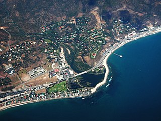
Malibu is a beach city in the Santa Monica Mountains region of Los Angeles County, California, about 30 miles (48 km) west of downtown Los Angeles. It is known for its Mediterranean climate, its strip of beaches stretching 21 miles along the Pacific Ocean coast, and for its longtime status as the home of numerous affluent Hollywood celebrities and executives. Although a high proportion of its residents are entertainment industry figures with multi-million dollar mansions, Malibu also features several middle- and upper-middle-class neighborhoods. The Pacific Coast Highway traverses the city, following along the South Coast of California. As of the 2020 census, the city's population was 10,654. The ongoing 2025 Palisades Fire devastated Malibu, with almost all of the beachfront homes near its center destroyed.

Westlake Village is a city in Los Angeles County, California on its western border with Ventura County. Upon its incorporation in 1981, Westlake Village became the 82nd municipality of Los Angeles County. The population of the city was 8,029 at the 2020 census, down from 8,270 at the 2010 census.

The Santa Monica Mountains are a coastal mountain range in Southern California, next to the Pacific Ocean. It is part of the Transverse Ranges. The Santa Monica Mountains National Recreation Area encompasses this mountain range. Because of its proximity to densely populated regions, it is one of the most visited natural areas in California.

Pacific Palisades is a neighborhood in the Westside region of the city of Los Angeles, California, situated about 20 miles (32 km) west of downtown Los Angeles. Starting on January 7, 2025, the majority of Pacific Palisades was severely affected and destroyed by the Palisades Fire, a part of the wider, and ongoing, Southern California wildfires.
The Santa Monica Mountains Conservancy is an agency of the state of California in the United States founded in 1980 and dedicated to the acquisition of land for preservation as open space, for wildlife and California native plants habitat Nature Preserves, and for public recreation activities.

Malibu Creek State Park is a state park of California, United States, preserving the Malibu Creek canyon in the Santa Monica Mountains. The 8,215-acre (3,324 ha) park was established in 1974. Opened to the public in 1976, the park is also a component of Santa Monica Mountains National Recreation Area.
Porter Ranch is a suburban neighborhood of the City of Los Angeles, in the northwest portion of the San Fernando Valley.

Topanga is an unincorporated community in western Los Angeles County, California, United States. Located in the Santa Monica Mountains, the community exists in Topanga Canyon and the surrounding hills. The narrow southern portion of Topanga at the coast is between the city of Malibu and the Los Angeles neighborhood of Pacific Palisades. For statistical purposes, the United States Census Bureau has defined Topanga as a census-designated place (CDP). As of the 2020 census the population of the Topanga CDP was 8,560. The ZIP code is 90290 and the area code is primarily 310, with 818 only at the north end of the canyon. It is in the 3rd County Supervisorial district.

Topanga State Park is a California state park located in the Santa Monica Mountains, within Los Angeles County, California. It is part of the Santa Monica Mountains National Recreation Area.

The Santa Monica Mountains National Recreation Area is a United States national recreation area containing many individual parks and open space preserves, located primarily in the Santa Monica Mountains of Southern California. The SMMNRA is in the greater Los Angeles region, with two thirds of the parklands in northwest Los Angeles County, and the remaining third, including a Simi Hills extension, in southeastern Ventura County.
Ramirez Canyon Park is a public park owned by the state of California. Barbra Streisand donated this estate to the state-run Santa Monica Mountains Conservancy in 1993. The estate has 22.5 acres (9.1 ha) of lush vegetation, streams, and bridges. There are five homes on the estate.
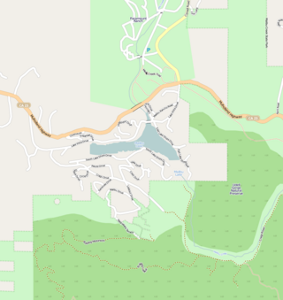
Malibou Lake is a small reservoir surrounded by a residential development in the Santa Monica Mountains near Agoura Hills, California. Adjacent to Malibu Creek State Park and within the Santa Monica Mountains National Recreation Area, it is situated between Malibu Beach and the Conejo Valley. It was created in 1922 after the Malibu Lake Club Dam was built at the confluence of two creeks. The lake, and community of 250 residents are private.
The 1978 Agoura-Malibu firestorm was a firestorm fueled by at least eight significant wildfires in the Los Angeles area on October 23, 1978. At around noon that day, an arsonist started a fire that eventually burned 25,000 acres (10,000 ha) from Cornell to Broad Beach in Malibu. The first fire alarm in Agoura was reported at 12:11 pm, and by 2:30 pm, the fire had reached the Pacific Ocean 13 miles (21 km) south in Malibu. It had been declared a Level 2 fire at 1:57 pm.
Monte Nido is an unincorporated community in western Los Angeles County, California, United States. Monte Nido is located in the Santa Monica Mountains 3 miles (4.8 km) north of Malibu. The L.A. County Fire Department fire station at Monte Nido hosts one of the LADWP's remote rainfall monitoring systems.
Malibu Vista is an unincorporated community in Los Angeles County, California, United States. Malibu Vista is located in the Santa Monica Mountains 1.6 miles (2.6 km) north of the Pacific Ocean at Malibu. Malibu Vista, one of a handful of residential tracts in the Malibu–Topanga hills, is the one relatively closest to Point Dume, and is in the same canyon as Malibu Mar Vista.
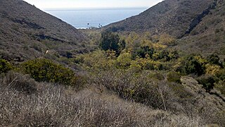
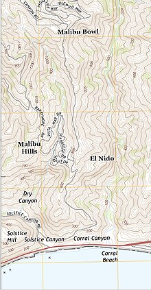
The Corral Canyon is a valley in Los Angeles County, California, United States. Located in the Santa Monica Mountains, it slopes down to the striking and diverse terrain of the Malibu coast.

The Woolsey Fire was a wildfire that started in Los Angeles County and spread north to neighboring Ventura County, both located in the U.S. state of California. The fire ignited on November 8, 2018 and was not fully contained until November 21, 2018. The fire burned 96,949 acres of land, destroyed 1,643 structures, killed three people, and prompted the evacuation of more than 295,000 people. It was one of several fires in California that ignited on the same day, along with the nearby Hill Fire and the destructive Camp Fire in Northern California.