Redondo Beach was originally part of the 1785 Rancho San PedroSpanish land grant that later became the South Redondo area. The primary attractions include Municipal Pier and the sandy beach, popular with tourists and a variety of sports enthusiasts. The Southern terminus of the Metro Rail K Line (formerly the Western Terminus of the Metro Rail C Line) is in North Redondo Beach.
History
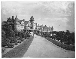
Don Manuel Domínguez, a signer of the Californian Constitution and owner of Rancho San Pedro, which included all of modern-day Redondo.View of Redondo Beach Pier and railroad station from the Redondo Hotel, c.1900Redondo Beach, 1906
The South Bay area was originally inhabited by the Tongva tribe of Native Americans. Archeological work in the nearby Chowigna excavation show evidence of inhabitants as far back as 7,100 years ago. The Chowigna band of Tongva used the site of today's Hopkins Wilderness Park in Redondo Beach, (formerly Nike missile site LA-57 from 1956 to 1963,) as a lookout place.[11] The wetlands located at the site of the retired AES power plant in Redondo Beach were a source of foods including halibut, lobster, and sea bass, and also of salt.[12]
The Tongva village of Ongovanga or Onoova-nga,[13] meaning "Place of Salt," was located near a salt lake the old Redondo Salt Lake,[14] "a spring-fed salt lake about 200 yards [180m] wide and 600 yards [550m] long situated about 200 yards from the ocean".[15] Up through the 1700s, the Chowigna bartered salt from the lake with other tribes.[16]
The Chowigna were relocated to missions in 1854, when Manuel Dominguez sold 215 acres (87ha) of Rancho San Pedro, including the lake, to Henry Allanson and William Johnson for the Pacific Salt Works.[15][17][18]
Redondo Beach saltwater bathhouse, constructed by Henry E. Huntington, c.1910The Hotel Redondo which stood in Redondo Beach until 1925.
In 1983, the city of Redondo Beach adopted a resolution “recognizing the Goodyear Airship Columbia (aka Goodyear blimp) as the “Official Bird of Redondo Beach.”[20]
In 2022, the Redondo Beach government (along with the governments of Torrance, Carson, and Whittier) sued the California state government, seeking to block the California HOME Act (SB 9), which permits the construction of duplexes and fourplexes on lots.[21] Redondo Beach mayor Bill Brand has argued that there is no housing crisis in Redondo Beach.[22]
In 2023, Redondo Beach rejected an application to transform the lot of an aging waterfront power plant into a village-style complex of 2,700 residential units (including 540 affordable units) and commercial space on the grounds that the application was incomplete. The City was sued by “Yes in My Backyard”.. But the lawsuit is unresolved as the property is in bankruptcy hearings.[23][24]
Bill Brand became mayor of Redondo Beach after spearheading the effort to block a 525,000 square foot mall project in King Harbor.. Brand had also successfully negotiated a reduction the number of apartment units in a mixed use development along PCH.[22] The city's residents and political leaders have long advocated to retire the plant and allow it to be restored to its natural wetland state.[25][26][27] The city has also participated in legal proceedings to preserve its ability to participate in residential zoning decisions, including the discretion to regulate single-family homes from being transformed by for-profit developers into “six-on-a-lots.”[22][28]
In 2024, Redondo Beach became the first city to achieve “Functional Zero” homelessness in LA County. South Bay Council of Governments (SBCOG) defines “Functional Zero” as more people exiting homelessness than entering it, and also requires that the median time in homelessness be less than 90 days. SBCOG noted Redondo’s transitional pallet shelters, “Homeless Court”, Project Homekey permanent supportive housing, and other homeless services. [29]
According to the United States Census Bureau, the city has a total area of 6.2 square miles (16km2), over 99% of it land.
Redondo Beach was originally part of the 1784 Rancho San Pedro Spanish land grant of the 43,000-acre (170km2) Dominguez Rancho that later became the ten-mile (16km) ocean frontage of Rancho Sausal Redondo.
Climate
Redondo Beach has a warm-summer Mediterranean climate (Köppen climate classification: Csb) with mild winters and warm, almost rainless summers. The coldest months are December through March, and the warmest months are July through September. Redondo Beach has mild temperatures year round due to its coastal location.
Climate data for Redondo Beach, California (normals 2000–2020, extremes 2000–present)
Redondo Beach first appeared as a city in the 1890 United States census as part of the now defunct Chataqua Township.[34]
2020 census
Redondo Beach city, California – Racial and ethnic composition Note: the US Census treats Hispanic/Latino as an ethnic category. This table excludes Latinos from the racial categories and assigns them to a separate category. Hispanics/Latinos may be of any race.
Redondo Beach, like its neighboring beach towns, has become one of the most exclusionary cities in Los Angeles by limiting housing production, resulting in a median home costing $1.4 million, 60% higher than the regional average for Los Angeles.[27]
2010
The 2010 United States census[51] reported that Redondo Beach had a population of 66,748. The population density was 10,751.1 inhabitants per square mile (4,151.0/km2). The racial makeup of Redondo Beach was 49,805 (74.6%) White (65.2% Non-Hispanic White),[8] 1,852 (2.8%) African American, 291 (0.4%) Native American, 8,004 (12.0%) Asian, 199 (0.3%) Pacific Islander, 2,725 (4.1%) from other races, and 3,872 (5.8%) from two or more races. There were 10,142 residents of Hispanic or Latino ancestry, of any race (15.2%).
The Census reported that 66,317 people (99.4% of the population) lived in households, 367 (0.5%) lived in non-institutionalized group quarters, and 64 (0.1%) were institutionalized.
There were 29,011 households, out of which 7,825 (27.0%) had children under the age of 18 living in them, 12,507 (43.1%) were opposite-sex married couples living together, 2,515 (8.7%) had a female householder with no husband present, 1,207 (4.2%) had a male householder with no wife present. There were 1,904 (6.6%) unmarried opposite-sex partnerships, and 179 (0.6%) same-sex married couples or partnerships. 9,252 households (31.9%) were made up of individuals, and 2,145 (7.4%) had someone living alone who was 65 years of age or older. The average household size was 2.29. There were 16,229 families (55.9% of all households); the average family size was 2.94.
Redondo Beach had 12,887 people (19.3%) under the age of 18, 4,198 people (6.3%) aged 18 to 24, 23,149 people (34.7%) aged 25 to 44, 19,532 people (29.3%) aged 45 to 64, and 6,982 people (10.5%) who were 65 years of age or older. The median age was 39.3 years. For every 100 females, there were 99.1 males. For every 100 females age 18 and over, there were 97.2 males.
There were 30,609 housing units at an average density of 4,930.2 unitsper square mile (1,903.6 units/km2), of which 14,917 (51.4%) were owner-occupied, and 14,094 (48.6%) were occupied by renters. The homeowner vacancy rate was 0.9%; the rental vacancy rate was 5.3%. 36,796 people (55.1% of the population) lived in owner-occupied housing units and 29,521 people (44.2%) lived in rental housing units.
According to the 2010 United States census, Redondo Beach had a median household income of $99,496, with 5.4% of the population living below the federal poverty line.[8]
2000
Shoreline of Redondo Beach, California
As of the census[52] of 2000, there were 63,261 people, 28,566 households, and 15,254 families residing in the city. The population density was 10,065.4 inhabitants per square mile (3,886.3/km2). There were 29,543 housing units at an average density of 4,700.6 unitsper square mile (1,814.9 units/km2). The racial makeup of the city was 78.6% White, 9.1% Asian, 2.5% African American, 0.5% Native American, 0.4% Pacific Islander, 4.4% from other races, and 4.6,% from two or more races. Hispanic or Latino residents of any race were 13.5% of the population.
There were 28,566 households, out of which 23.3% had children under the age of 18 living with them, 40.6% were married couples living together, 9.0% had a female householder with no husband present, and 46.6% were non-families. 33.1% of all households were made up of individuals, and 5.9% had someone living alone who was 65 years of age or older. The average household size was 2.21 and the average family size was 2.87.
In the city, 18.8% of the population was under the age of 18; 6.1%, aged 18 to 24; 43.1%, aged 25 to 44; 23.6%, aged 45 to 64; and 8.5% aged 65 or older. The median age was 37 years. For every 100 females, there were 101.5 males. For every 100 females age 18 and over, there were 99.8 males.
According to a 2007 estimate, the median income for a household in the city was $93,274, and the median income for a family was $108,753.[53] Males had a median income of $56,796 versus $45,204 for females. The per capita income for the city was $38,305. About 4.0% of families and 5.9% of the population were below the poverty line, including 6.2% of those under age 18 and 6.1% of those age 65 or over.
Economy
According to the city's 2020 Comprehensive Annual Financial Report,[54] the top employers in the city are:
Redondo Beach's City Council elections are held on the first Tuesday after the first Monday in March of odd-numbered years after the City Attorney notified California's Secretary of State of not moving both its City Council and Board of Education elections to a statewide primary or general election starting in 2018. The elections are all-mail instead of in-person.
The City of Redondo Beach is a charter city.[64] Almost two thirds of the residents in Los Angeles County, the majority in Southern California, and a plurality of Californians live in charter cities according to the 2010 US Census.[65] As a charter city, Redondo Beach can adopt amendments to its city charter.[66]
The Redondo Beach Unified School District serves the city. Redondo Union High School is the zoned high school, with the adjoining campus of Patricia Dreizler Continuation High School located to the east of the Redondo Union High School main grounds serving as a continuation school. The Redondo Beach Learning Academy, a community day school houses 9th-12th graders, is located on the South Bay Adult School campus in Redondo Beach. Dreizler continues to be recognized as a California Model Continuation High School.[70] The Independent Study Program supports grades 9-12 and is housed on the Patricia Deizler campus.[71][72][73] Additionally, Redondo Beach has two middle schools, Adams Middle School and Parras Middle School. Adams Middle School, located in North Redondo Beach, primarily serves 6th to 8th grade students in the North Redondo area, with Parras Middle School being the designated middle school of South Redondo Beach.[74][75] The city also has eight established elementary schools: Alta Vista, Beryl Heights, Birney, Jefferson, Lincoln, Madison, Tulita and Washington.[76] All twelve schools are evenly divided throughout the North and South areas of Redondo Beach, with five elementary schools and one middle school located in North/Central Redondo Beach; and three elementary schools, one middle school, and the singular designated high school placed in South Redondo Beach.[77] The Redondo Beach Educational Foundation was founded in 1992 and revitalized in 2008.[78]
The United States Postal Service operates the Redondo Beach Post Office at 1201 North Catalina Avenue,[80] the Redondo Beach Station #2 Post Office at 1715 Via El Prado,[81] the North Redondo Beach Post Office at 2215 Artesia Boulevard,[82] and the Galleria Post Office at Suite 377D at 1815 Hawthorne Boulevard.[83]
The Beach Cities Health District,[85] one of 78 California Health Districts,[86] is located in Redondo Beach. Created in 1955, as South Bay Hospital, to provide health and wellness services to the residents of Hermosa Beach, Manhattan Beach, and Redondo Beach. The district took on its current name in 1993. In 2002, Beach Cities Health District opened AdventurePlex,[87] a Manhattan Beach fitness facility for youth and their families of the three beach cities. AdventurePlex has mazes, tunnels, outdoor rock climbing walls, complex ropes courses, and an indoor gymnasium.
Redondo Beach Police Department
The Redondo Beach Police Department was established in the 1920s. The Police Department consists of 90 sworn members (officers) plus 57 non-sworn members.[88]
Redondo Beach Public Library
Redondo Beach Public LibraryCurrent Redondo Beach Public Library, main branch, from the civic center entrance
The first library in Redondo Beach began as a reading room in 1895. The first five-member Library Commission for the city was formed in November 1908. The library moved into the then City Hall's west wing in 1909 and eventually filled the entire west wing at 301 Emerald Street. In 1928 the Chamber of Commerce recommended a new library be built on the site previously occupied by the Hotel Redondo in what is now Veterans Park. The Veterans Park Library is a Spanish/Dutch colonial building designed by architect Lovel Bearse Pemberton and opened on July 2, 1930. It was placed on the National Register of Historic Places in 1981. After serving as the Main Library for the city for 60 years, a site adjacent to City Hall was identified for a new, modern Main Library building. The new Main Library for the City of Redondo Beach opened on July 8, 1995, at 303 N. Pacific Coast Highway. A North Branch Library was also established in 1930 and started at the Grant Community Hall, it then moved to its current location at 2000 Artesia Boulevard in 1949. A new North Branch Library was constructed on the site in 2009 and opened its doors on September 28, 2010. The North Branch Library is the first City owned Green building and received Gold LEED certification.[89]
The Smothers Brothers (Tom, born 1937; Dick, born 1939), musicians and actors; grew up in Redondo Beach and graduated from Redondo Union High School[92]
Shannon Brown, professional basketball player; resident
Henry E. Huntington, owned 90 percent of Redondo Beach in 1905 and helped promote surfing by hiring George Freeth away from Abbot Kinney's Venice of America.[100]
Henry Rollins (born 1961), musician, actor, writer, television and radio host, comedian, Black Flag member; former resident.[108]
William Starke Rosecrans, a Delaware native, inventor, coal-oil company executive, diplomat, politician, and United States Army Major General during the American Civil War, bought 16,000 acres (65km2) of land which later became Redondo Beach. Rosecrans Avenue, a major street in northern South Bay, is named after him. He died there at Rancho Sausal Redondo in 1898.
American Dad references the fact that the Goodyear Blimp is Redondo's official Bird in "Family Time" (S16E19)[20][120]
Film
Parts of Point Break such as the gas station fire/explosion scene took place at the intersection of Beryl and Catalina, and the foot chase past the Dive N' Surf shop.
↑ Brand, Bill. ""Heart Park" Restoring Redondo Beach"(PDF). The Foggy View, Supplement to the March 2005 Southern Sierran, Sierra Club Palos Verdes - South Bay Group / Angeles Chapter. Archived from the original(PDF) on July 16, 2014. Retrieved March 15, 2014.
↑ Brand, Bill. ""Heart Park" Restoring Redondo Beach"(PDF). The Foggy View, Supplement to the March 2005 Southern Sierran, Sierra Club Palos Verdes - South Bay Group / Angeles Chapter. Archived from the original(PDF) on July 16, 2014. Retrieved March 15, 2014.
1 2 3 Dillon, Liam; Campa, Andrew (November 14, 2022). "Crude emails reveal nasty side of a California beach city's crusade to halt growth". Los Angeles Times. Nevertheless, like its neighboring coastal communities, Redondo Beach has become one of the most exclusionary cities in Los Angeles, according to a recent study by the Washington, D.C.-based Urban Institute, which found that Redondo Beach has had limited housing production despite intense demand to live there. Redondo Beach's median home value of $1.4 million is nearly 60% higher than L.A.'s regional average and 44% more than it was five years ago, according to real estate firm Zillow. And more than half of Redondo Beach's residents are white, nearly double the rate of the L.A. area, per U.S. census data.
1 2 Moser, Patrick (2022). Surf and Rescue: George Freeth and the Birth of California Beach Culture. Sport and society. Urbana: University of Illinois Press. ISBN978-0-252-04444-1.
↑ "Seen The Latest?". Readout (weekly bulletin for TRW employees). Vol.VI, no.35. September 21, 1964. Space Park and M-1 will serve as 'sets' for ABC-TV's Outer Limits telecast this Saturday evening, 26 September. The episode, entitled 'Cold Hands--Warm Heart,' will be broadcast over Channel 7 at 7:30 pm.
↑ "Warner Brothers Films 'Moonshot' Sequences at Space Park". Readout (weekly bulletin for TRW employees). Vol.VIII, no.37. October 14, 1966. Moonshot, starring Robert Duval, James Caan, Joanna Moore, and Michael Murphy, is the realistic story of an 'Apollo 3' flight to the Moon ... [photo caption] If you were wondering what was going on at Space Park last week, it was a Warner Brothers film crew doing some scenes for their new movie Moonshot.
This page is based on this Wikipedia article Text is available under the CC BY-SA 4.0 license; additional terms may apply. Images, videos and audio are available under their respective licenses.