South Bay (Los Angeles County)

Last updated

South Bay
Region
South Bay Los Angeles.png
The South Bay and surrounding regions in Southern California
Coordinates: 33°50′13″N118°19′05″W / 33.83694°N 118.31806°W / 33.83694; -118.31806
CountryUnited States
StateCalifornia
County Los Angeles

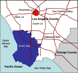
The South Bay is a region of the Los Angeles metropolitan area, located in the southwest corner of Los Angeles County. The name stems from its geographic location stretching along the southern shore of Santa Monica Bay. The South Bay contains sixteen cities plus portions of the City of Los Angeles and unincorporated portions of the county. The area is bounded by the Pacific Ocean on the south and west and generally by the City of Los Angeles on the north and east. [1]

Contents

Neighborhoods

The South Bay includes: [2]

The region is bordered on the north by the Westside region of Los Angeles, on the northeast by the South Los Angeles region and on the east and southeast by the Gateway Cities.

South Bay Cities Council of Governments

The South Bay Cities Council of Governments (SBCCOG) is a joint powers authority government agency made of politicians from the sixteen South Bay cities and unincorporated Los Angeles County that share the goal of maximizing the quality of life and productivity of the South Bay region of Los Angeles. The SBCCOG members are Carson, El Segundo, Gardena, Hawthorne, Hermosa Beach, Inglewood, Lawndale, Lomita, Manhattan Beach, Palos Verdes Estates, Rancho Palos Verdes, Redondo Beach, Rolling Hills, Rolling Hills Estates, Torrance, the Harbor City/San Pedro/Wilmington communities of the City of Los Angeles and the unincorporated areas of the County of Los Angeles District 2 and 4.

Major employers

Port of Los Angeles

The Port of Los Angeles, sprawling across the shorelines of San Pedro and Wilmington, is the busiest in the United States. When combined with the Port of Long Beach, it is the fifth-busiest in the world. Traditionally, most of the populations of Wilmington and San Pedro have worked for the port in some capacity. It is increasingly the primary driver of the Southern California economy. Industrial growth in the Inland Empire is almost entirely attributable to increased port traffic since the 1980s. The massive increase in cargo volume has created significant air pollution (especially of particulate matter in neighboring communities, resulting from the combustion of low-grade marine diesel fuel).

Aerospace

The South Bay is the traditional home of Southern California's aerospace industry. While considerably shrunken from its Cold War peak, it still represents a major economic force, employing thousands in high-skill, high-wage engineering positions and generating enormous amounts of tax revenue. Northrop Grumman has a major facility in El Segundo where the F/A-18 Hornet fuselage is manufactured, as well as the headquarters of the Space Technology division in Redondo Beach and a facility at the Hawthorne Municipal Airport. Howmet Fastening Systems, a subsidiary of Howmet Aerospace, has their corporate headquarters located in Torrance with manufacturing facilities in both Torrance and Carson. Boeing and Lockheed Martin also maintain extensive production facilities throughout the South Bay and Raytheon maintains a facility in El Segundo. The Los Angeles Air Force Base and neighboring Aerospace Corporation in El Segundo are a main focus of aerospace research activity and serve as the primary development facilities for military satellites and other space programs. DirecTV, a former subsidiary of Hughes Aircraft, is also headquartered in El Segundo for the same reason. SpaceX is also headquartered in the South Bay in Hawthorne.

Oil refining

View of the Palos Verdes Peninsula. Los Angeles in the distance. Palos Verdes (aerial view).jpg
View of the Palos Verdes Peninsula. Los Angeles in the distance.

Petroleum refining is another important component of the South Bay's economy. Major South Bay refiners include Tesoro (ARCO facility in Carson), Chevron (El Segundo), Phillips 66 (Wilmington), PBF Energy (Torrance), Tesoro (Wilmington), and Valero (Wilmington). These refiners supply a large share of petroleum products for Southern California as well as for Nevada and Arizona.

Automotive

Japanese automobile manufacturer Honda maintains its North American headquarters in the South Bay, in the city of Torrance. (Nissan was also headquartered in the South Bay until late 2005, but relocated to Tennessee, citing the high cost of running a business in California. Toyota relocated to Plano, Texas in 2017 for many of the same reasons.) While these locations are largely the legacy of the region's historical importance as a Japanese-American population center, it has proven fortuitous for two reasons; first, it enables closer oversight of vehicle import operations at the nearby ports; and second, it gives them proximity to the automobile customization culture that is prominent in nearby South Los Angeles. Tesla is stationed near the headquarters of SpaceX in Hawthorne.

Higher education

Transportation

The Harbor (I-110), San Diego (I-405), Gardena (SR 91), and Century (I-105) Freeways provide the region with its principal transportation links.

The Los Angeles MTA's A Line (opened in 1990 as the Blue Line) is a light rail line running between Downtown Los Angeles and Downtown Long Beach. It was the first of the MTA's modern rail lines since the 1961 demise of the Pacific Electric Railway's Red Car system. The C Line (opened in 1995 as the Green Line, together with the Glenn Anderson Freeway), a freeway-median light rail line, also serves the South Bay. It runs between Redondo Beach and Norwalk in the median of the Century Freeway (Interstate 105), providing indirect access to LAX via a shuttle bus and future automated people mover. The K Line opened from Expo/Crenshaw station to Westchester/Veterans station, but is expected to be fully operational to Aviation/Imperial station in 2024.

Several ports and harbors in the South Bay provide access to Santa Catalina Island, a popular resort. In addition, LAX borders El Segundo to the north in the neighborhood of Westchester, Los Angeles. The area is also home to two public airports; Zamperini Field in Torrance and Hawthorne Municipal Airport in Hawthorne.

Media

In addition to the Los Angeles Times , the South Bay cities are served by daily papers, the Daily Breeze , the weeklies The Beach Reporter, The Easy Reader and South Bay Community News , a bi-monthly real estate magazine, South Bay DIGS and lifestyle publication 'Southbay Magazine'. The National Football League has it's West Coast headquarters and production facility for NFL Network, NFL RedZone and the NFL.com app in Inglewood.

Music

The South Bay has a rich history in music, and has produced a number of significant rock bands, like Hawthorne natives The Beach Boys in the early 1960s, and continuing particularly in punk music. Other notable South Bay-based artists include:

Black Flag guitarist Greg Ginn's SST record label, a seminal alternative rock label of the 1980s, maintained its headquarters in Lawndale.

Sports and entertainment

The South Bay is host to many professional sports teams and entertainment venues. The Los Angeles Rams and Los Angeles Chargers of the National Football League play at SoFi Stadium in Inglewood. The LA Galaxy of Major League Soccer play their home games at Dignity Health Sports Park in Carson.

The Los Angeles Clippers of the National Basketball Association will play in their new stadium, Intuit Dome, in Inglewood beginning 2024.

Various entertainment venues are located in the South Bay, including SoFi Stadium, Kia Forum, and YouTube Theater in Inglewood, Dignity Health Sports Park in Carson, and Toyota Sports Center in El Segundo. Three casinos also operate in the South Bay; the Hollywood Park Casino in Inglewood and the Normandie Casino and Hustler Casino in Gardena.

See also

Related Research Articles

<span class="mw-page-title-main">Rolling Hills Estates, California</span> City in California, United States

Rolling Hills Estates is a city in Los Angeles County, California, United States. On the northern side of the Palos Verdes Peninsula, facing Torrance, Rolling Hills Estates is mostly residential. Incorporated in 1957, Rolling Hills Estates has many horse paths. The population was 8,067 at the 2010 census, up from 7,676 at the 2000 census. In 2018, the population rose to 8,141, and the 2020 census counted 8,280 residents.

<span class="mw-page-title-main">Area codes 310 and 424</span> Area codes in the Los Angeles metropolitan area

Area codes 310 and 424 are telephone area codes in the North American Numbering Plan (NANP) for the U.S. state of California. The numbering plan area includes the West Los Angeles and South Bay areas of Los Angeles County, a small portion of Ventura County, and Santa Catalina Island, which is located 26 miles (42 km) south.

Manuel Dominguez High School is a four-year public high school located in Compton, California. It is part of the Compton Unified School District.

The San Pedro Pastoral Region is a pastoral region of the Archdiocese of Los Angeles in the Roman Catholic Church. It covers Long Beach and southern Los Angeles County, with its headquarters in Lakewood. The current regional auxiliary bishop is Bishop Marc V. Trudeau. The region has 68 parishes, 10 high schools, many elementary schools, 6 hospitals, and no Spanish missions.

<span class="mw-page-title-main">Vermont Avenue</span> Major thoroughfare in Los Angeles, CA

Vermont Avenue is one of the longest running north–south streets in City of Los Angeles and Los Angeles County, California. With a length of 23.3 miles (37.5 km), is the third longest of the north–south thoroughfares in the region. For most of its length between its southern end in San Pedro and south of Downtown Los Angeles, it runs parallel to the west of the Harbor Freeway (I-110).

<span class="mw-page-title-main">California's 36th congressional district</span> U.S. House district for California

California's 36th congressional district is a U.S. congressional district in California. The 36th district is located primarily in the South Bay and Westside regions of Los Angeles. It takes in the cities of Beverly Hills, Santa Monica, the west side of Culver City, Hermosa Beach, Rancho Palos Verdes, Redondo Beach, Palos Verdes Estates, Rolling Hills Estates, El Segundo, Lomita, Manhattan Beach, and the west side of Torrance, as well as the Los Angeles neighborhoods of Venice, Playa del Rey, Palms, Cheviot Hills, Westwood Village, West Los Angeles, Mar Vista, Westchester, Marina Peninsula, and west side Harbor City.

<span class="mw-page-title-main">California's 43rd congressional district</span> U.S. House district for California

California's 43rd congressional district is a congressional district in the U.S. state of California that is currently represented by Democrat Maxine Waters. The district is centered in the southern part of Los Angeles County, and includes portions of the cities of Los Angeles and Torrance. It includes the entirety of the cities of Hawthorne, Lawndale, Gardena, Inglewood, and Lomita. From 2003 until 2013, the 43rd district was based in San Bernardino County. The Hispanic-majority district encompassed the southwestern part of the county, and included San Bernardino and Rialto.

Law enforcement in Los Angeles County is conducted by a variety of law enforcement agencies.

<span class="mw-page-title-main">Rancho San Pedro</span> Spanish land grant in California

Rancho San Pedro was one of the first California land grants and the first to win a patent from the United States. The Spanish Crown granted the 75,000 acres (300 km2) of land to soldier Juan José Domínguez in 1784, with his descendants validating their legal claim with the Mexican government at 48,000 acres (190 km2) in 1828, and later maintaining their legal claim through a United States patent validating 43,119 acres (174.50 km2) in 1858. The original Spanish land grant included what today consists of the Pacific coast cities of Los Angeles harbor, San Pedro, the Palos Verdes peninsula, Torrance, Redondo Beach, Hermosa Beach, and Manhattan Beach, and east to the Los Angeles River, including the cities of Lomita, Gardena, Harbor City, Wilmington, Carson, Compton, and western portions of Long Beach and Paramount.

<span class="mw-page-title-main">Los Angeles Area Council</span>

Founded in 1915, the Greater Los Angeles Area Council (GLAAC) (#033) served most of the City of Los Angeles as well as several other cities in the greater Los Angeles area. It was one of five Boy Scouts of America councils in Los Angeles County, California. Since its founding in 1915, the Los Angeles Area Council has brought its purpose and values to millions of youth. The Council served 54,567 youth in the Greater Los Angeles Area in 2008 alone.

<span class="mw-page-title-main">Walteria, Torrance</span> Neighborhood in Southern California, United States

Walteria is a neighborhood in south Torrance in southern California, United States. It is bounded by Hawthorne Boulevard on the east, Pacific Coast Highway on the south, Lomita Boulevard to the north, and Calle Mayor to the west. The local zip code is 90505.

The Southern California Association of Governments (SCAG) is the Metropolitan Planning Organization (MPO) of six of the ten counties in Southern California, serving Imperial County, Los Angeles County, Orange County, Riverside County, San Bernardino County, and Ventura County. San Diego County's MPO is the San Diego Association of Governments, which is an unrelated agency.

This article covers streets in Los Angeles, California between and including 41st Street and 250th Street. Major streets have their own linked articles; minor streets are discussed here.

<span class="mw-page-title-main">Rancho Sausal Redondo</span> Pre-statehood California land grant

Rancho Sausal Redondo was a 22,458-acre (91 km2) Mexican land grant in present day Los Angeles County, California given in 1837 to Antonio Ygnacio Ávila by Juan Alvarado Governor of Alta California. Rancho Sausal Redondo covered the area that now includes Playa Del Rey, El Segundo, Manhattan Beach, Lawndale, Hermosa Beach, Inglewood, Hawthorne, and Redondo Beach.

Dominguez Channel is a 15.7-mile-long (25.3 km) river in southern Los Angeles County, California, in the center of the Dominguez Watershed of 133 square miles (340 km2).

Municipal Area Express provided mass transportation in suburban Los Angeles. The purpose of the system was to provide rush hour commuter service between the city's southwestern suburbs and the major places of employment near Los Angeles International Airport. Three routes each provided service four times per weekday. Service was discontinued on 28 June 2013.

<span class="mw-page-title-main">Redondo Beach via Gardena Line</span> Pacific Electric streetcar line (1911–1940)

Redondo via Gardena was a line of the Pacific Electric Railway. One of two routes to Redondo Beach, this one was faster than the Redondo Beach via Playa del Rey Line as a result of its routing along the quadruple-tracked Watts main line.

<span class="mw-page-title-main">San Pedro via Gardena Line</span> Pacific Electric streetcar route (1903–1940)

San Pedro via Gardena was an interurban line of the Pacific Electric Railway. This was the railway's original route to San Pedro. The line was essential in the establishment of light industry in Torrance. The route closely paralleled the present-day Harbor Transitway.

<span class="mw-page-title-main">Hawthorne–El Segundo Line</span> Pacific Electric streetcar line (1914–1930)

The Hawthorne–El Segundo Line was an interurban railway route of the Pacific Electric Railway. It was built to transport oil from the Standard Oil Refinery in El Segundo and also saw passenger service. Unlike most corridors which hosted Pacific Electric passengers, the line remains largely intact as the Union Pacific El Segundo Industrial Lead.

References