North Coast (California)

Last updated
North Coast
Redwood National Park, fog in the forest.jpg
Coast Redwood forest in Redwood National Park
Map of the North Coast region of California.png
Location of the North Coast in California
(The lighter shaded area includes Bay Area counties that are included in some definitions)
CountryUnited States
State California
Area
  Land10,176.86 sq mi (26,357.9 km2)
Population
  Total987,361
  Estimate 
(2019) [2]
1,003,281
  Density99/sq mi (38/km2)

The North Coast of California (also called the Redwood Empire [3] or the Redwood Coast in reference to the dense redwood forests throughout the region) is a region in Northern California that lies on the Pacific coast between San Francisco Bay and the Oregon border. It commonly includes Mendocino, Humboldt, and Del Norte counties and sometimes includes Lake and two counties from the San Francisco Bay area, Marin and Sonoma.

Contents

Cities

Much of the area is rural containing few major cities. The only city with a population of over 100,000 is Santa Rosa (population 178,000) in Sonoma County, which is the largest city of the North Coast under the five-county definition. Eureka (population 27,000) in Humboldt County is the largest under the three-county definition. Despite their relatively smaller size to the major cities elsewhere in the state, many of the region's cities and towns have historical importance to the state or regional importance.

County seats

Geography

The Pacific Ocean coast stretches from San Francisco Bay to Humboldt Bay and on to the border of Oregon. The coastline is often inaccessible, and includes rocky cliffs and hills, streams and tide pools. The coastline from Centerville Beach near Ferndale to the mouth of the Klamath River is mostly beach accessible and there are many small towns and a few cities along Highway 101, the main route through the region. The sparsely populated interior territory further inland is characterized by rugged, often steep mountains, bisected by rivers and their typically narrow valleys and canyons, and dense redwood, Douglas fir, and oak forests. The climate can range from coast side lands drenched with fog in mild winters and summers to inland reaches baked by hot sunshine on long summer days, which, at higher elevations, can be blanketed with snow in winter.

Coastline in Sonoma Coast State Park CA 1 north of Jenner.jpg
Coastline in Sonoma Coast State Park

The southern portion of the North Coast is largely urbanized while the rest is mostly rural. The more remote northern areas are often referred to as being located "behind the Redwood Curtain." [4] A segment of the coastline in Mendocino and Humboldt Counties is known as the Lost Coast, and is only accessible by a few back roads. [5] Notable seaside beaches can be found at Marin Headlands and Point Reyes National Seashore in the south, with innumerable examples of remote or less used beaches north of the San Francisco Bay area.

The grandeur of the redwoods can be experienced throughout the region, from the protected groves of Muir Woods National Monument and Armstrong Redwoods State Natural Reserve in the south to the massive forests of Humboldt Redwoods State Park along the Avenue of the Giants in the north. Redwoods are also found in many other State and local parks, most of which are located along Highway 101 throughout the far North Coast. Other larger redwood parks include Prairie Creek Redwoods State Park, Del Norte Coast Redwoods State Park, Jedediah Smith Redwoods State Park and Redwood National and State Parks. In total, the redwood parks of the North Coast contain the vast majority of all remaining old-growth redwoods.

Demographics

Historical population
CensusPop.Note
1860 23,855
1870 42,42977.9%
1880 68,14660.6%
1890 89,46631.3%
1900 104,15916.4%
1910 133,71128.4%
1920 143,7207.5%
1930 175,34722.0%
1940 200,38014.3%
1950 307,19753.3%
1960 467,91752.3%
1970 576,29623.2%
1980 715,71824.2%
1990 841,24117.5%
2000 946,19312.5%
2010 987,3614.4%
2019 (est.)1,003,2811.6%
Sources: 1790–1990, 2000, 2010, 2019 [6] [7] [8]
Chart does not include Indigenous population figures.

2010

The 2010 United States Census reported that the North Coast region had a population of 987,361. The racial makeup was 771,611 (78.1%) White, 17,717 (1.8%) African American, 22,259 (2.3%) Native American, 37,461 (3.8%) Asian, 2,570 (0.3%) Pacific Islander, 91,107 (9.2%) from other races, and 44,636 (4.5%) from two or more races. Hispanic or Latino of any race were 197,308 persons (20.0%). [9]

Transportation infrastructure

Major highways

Public transportation

Public transportation serving the North Coast includes bus services provided by national regional operators Amtrak and Greyhound, regional and countywide bus services (such as Golden Gate Transit, Mendocino Transit Authority, Humboldt Transit Authority and Redwood Coast Transit) as well as bus services operated within individual municipalities (e.g., Cloverdale Transit, Petaluma Transit, and the Arcata and Mad River Transit System). Rail transit between Sonoma and Marin Counties is operated by Sonoma-Marin Area Rail Transit, with ferryboat connections from Marin County to San Francisco provided by Golden Gate Ferry.

Parts of these regions overlap parts of the North Coast:

Regions contained entirely within the North Coast:

The North Coast region is completely contained within:

See also

Related Research Articles

<span class="mw-page-title-main">Del Norte County, California</span> County in California, United States

Del Norte County is a county at the far northwest corner of the U.S. state of California, along the Pacific Ocean adjacent to the Oregon border. Its population is 27,743 as of the 2020 census, down from 28,610 from the 2010 census. The county seat and only incorporated city is Crescent City. Del Norte was pioneered and populated by Azorean Portuguese settlers and dairy farmers, which may account for the local pronunciation of the county name. Locals pronounce the county name as Del Nort, not Del Nor-teh as would be expected in Spanish.

<span class="mw-page-title-main">Humboldt County, California</span> County in California, United States

<span class="mw-page-title-main">Marin County, California</span> County in California, United States

Marin County is located in the northwestern part of the San Francisco Bay Area of the U.S. state of California. As of the 2020 census, the population was 262,231. Its county seat and largest city is San Rafael. Marin County is across the Golden Gate Bridge from San Francisco, and is included in the San Francisco–Oakland–Berkeley, CA Metropolitan Statistical Area.

<span class="mw-page-title-main">Mendocino County, California</span> County in California, United States

Mendocino County is a county located on the North Coast of the U.S. state of California. As of the 2020 census, the population was 91,601. The county seat is Ukiah.

<span class="mw-page-title-main">Sonoma County, California</span> County in California, United States

Sonoma County is located in the U.S. state of California. As of the 2020 United States Census, its population was 488,863. Its seat of government and largest city is Santa Rosa. It is to the north of Marin County and the south of Mendocino County. It is west of Napa and Lake Counties.

<span class="mw-page-title-main">Eureka, California</span> City in California, United States

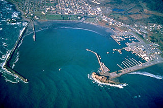
Eureka is the principal city and county seat of Humboldt County in the Redwood Empire region of California. The city is located on U.S. Route 101 on the shores of Humboldt Bay, 270 miles (435 km) north of San Francisco and 100 miles (161 km) south of the Oregon border. At the 2010 census, the population of the city was 27,191, and the population of Greater Eureka was 45,034.

<span class="mw-page-title-main">San Rafael, California</span> City in California, United States

San Rafael is a city and the county seat of Marin County, California, United States. The city is located in the North Bay region of the San Francisco Bay Area. As of the 2020 U.S. census, the city's population was 61,271, up from 57,713 in 2010.

<span class="mw-page-title-main">Cotati, California</span> City in California, United States

Cotati is an incorporated city in Sonoma County, California, United States, located approximately 45 mi (70 km) north of San Francisco in the 101 corridor between Rohnert Park and Petaluma. Cotati's population as of the 2020 Census was 7,584, making it the smallest incorporated community in Sonoma County.

<span class="mw-page-title-main">Santa Rosa, California</span> City in California, United States

Santa Rosa is a city in and the county seat of Sonoma County, in the North Bay region of the Bay Area in California. Its population as of the 2020 census was 178,127. It is the largest city in California's Wine Country and Redwood Coast. It is the fifth most populous city in the Bay Area after San Jose, San Francisco, Oakland, and Fremont; and the 25th most populous city in California.

<span class="mw-page-title-main">Northern California</span> American geographic and cultural region

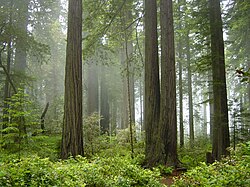
Northern California is a geographic and cultural region that generally comprises the northern portion of the U.S. state of California. Spanning the state's northernmost 48 counties, its main population centers include the San Francisco Bay Area, the Greater Sacramento area, the Redding, California, area south of the Cascade Range, and the Metropolitan Fresno area. Northern California also contains redwood forests, along with most of the Sierra Nevada, including Yosemite Valley and part of Lake Tahoe, Mount Shasta, and most of the Central Valley, one of the world's most productive agricultural regions.

<span class="mw-page-title-main">Golden Gate Bridge, Highway and Transportation District</span>

The Golden Gate Bridge, Highway and Transportation District is a special-purpose district that owns and operates three regional transportation assets in the San Francisco Bay Area: the iconic Golden Gate Bridge, the Golden Gate Ferry system and the Golden Gate Transit system. All three assets connect Marin County with San Francisco.

<span class="mw-page-title-main">Northwestern Pacific Railroad</span> Regional railroad in California, US

The “Northwestern Pacific Railroad” was a 271 mile mainline railroad from the ferry connections in Sausalito north to Eureka with a connection to the national railroad system at Schellville. The railroad has gone through a history of different ownership and operators but has maintained a generic name of reference as “The Northwestern Pacific.” Currently, only a 62-mile (100 km) stretch of mainline on the “South End” is operated by Sonoma-Marin Area Rail Transit (SMART), which operates both commuter and freight trains with plans for future extension north to Cloverdale. The “North End,” from Willits to Eureka which includes connections to the California Western Railroad] is currently out of service but saved by 2018 legislation to be converted into the Great Redwood Trail.

<span class="mw-page-title-main">California Coast Ranges</span> Mountain range

The Coast Ranges of California span 400 miles (644 km) from Del Norte or Humboldt County, California, south to Santa Barbara County. The other three coastal California mountain ranges are the Transverse Ranges, Peninsular Ranges and the Klamath Mountains.

<span class="mw-page-title-main">U.S. Route 101 in California</span> U.S. Highway in California

U.S. Route 101 (US 101) is a major north–south United States Numbered Highway, stretching from Los Angeles, California, to Tumwater, Washington. The California portion of US 101 is one of the last remaining and longest U.S. Routes still active in the state, and the longest highway of any kind in California. US 101 was also one of the original national routes established in 1926. Significant portions of US 101 between the Los Angeles area and the San Francisco Bay Area follow El Camino Real, the commemorative route connecting the former Alta California's 21 missions.

California's 2nd congressional district is a U.S. congressional district in California. Jared Huffman, a Democrat, has represented the district since January 2013. Currently, it encompasses the North Coast region and adjacent areas of the state. It stretches from the Golden Gate Bridge to the Oregon border, and includes all of the portions of Highway 101 within California that are north of San Francisco, excepting a stretch in Sonoma County. The district consists of Marin, Mendocino, Humboldt, Del Norte, and Trinity Counties, plus portions of Sonoma County. Cities in the district include San Rafael, Petaluma, Novato, Windsor, Healdsburg, Ukiah, Fort Bragg, Fortuna, Eureka, Arcata, McKinleyville, Crescent City, and northwestern Santa Rosa.

<span class="mw-page-title-main">Coastal California</span> Coastal portion of the U.S. state of California

Coastal California, also known as the California Coastline and the Golden Coast, refers to the coastal regions of the U.S. state of California. The term is not primarily geographical as it also describes an area distinguished by cultural, economic and political attributes.

<span class="mw-page-title-main">Frank P. Belotti</span> American politician

Frank P. Belotti was a Republican California State Assemblyman from 1951 to 1972. Due to redistricting, he represented both the 1st and 2nd Assembly districts over his career. A bridge, two parts of Route 101, and the main hall of the Humboldt County Fairgrounds are named for him.

<span class="mw-page-title-main">Santa Rosa Transit Mall</span>

The Santa Rosa Transit Mall is a major transfer point for several bus routes serving the city of Santa Rosa, California, located in Sonoma County, north of San Francisco, in the United States. From the Transit Mall, passengers can travel throughout Santa Rosa and Sonoma County, plus destinations that connect the city with the rest of the San Francisco Bay Area and the Redwood Empire.

The Great Redwood Trail is a proposed multi-use rail-to-trail project connecting San Francisco and Humboldt bays in Northern California. Most of the trail will be built on the rail bed of the defunct Northwestern Pacific Railroad along the Eel River Canyon by the Great Redwood Trail Agency. The southern portion will be built by Sonoma–Marin Area Rail Transit (SMART) along their commuter rail line. The trail route is within 5 counties, 14 cities and the ancestral territory of many tribes. Some portions have already constructed by local jurisdictions with more being developed in cooperation with local governments.

References

  1. "Annual Estimates of the Resident Population: April 1, 2010 to July 1, 2016 Estimates" . Retrieved April 27, 2017.
  2. "Population and Housing Unit Estimates" . Retrieved December 3, 2019.
  3. Rupprecht, Rich (November 6, 2008). "Primed for the Playoffs". The Press Democrat . The New York Times Company . Retrieved December 23, 2008.
  4. Flinn, John (May 11, 2003). "Behind the Redwood Curtain: Humboldt a separate world of misty groves, offbeat towns and protected wildlife -- and one wild race". San Francisco Chronicle . p. C-1. Retrieved November 10, 2009.
  5. "King Range National Conservation Area". Bureau of Land Management. Archived from the original on 2012-07-02. Retrieved 2013-07-07.
  6. "California Grew By 356,000 Residents in 2013" (PDF). Archived from the original (PDF) on May 2, 2014. Retrieved September 26, 2016.
  7. "1990 Census of Population and Housing, Unit Counts, United States, 1990 CPH-2-1" (PDF). Population and Housing Unit Counts, Population Estimates 1790–1990, pages 26–27. United States Census Bureau, U.S. Department of Commerce Economics and Statistics Administration. August 20, 1993. Retrieved January 1, 2012.
  8. "California QuickFacts from the US Census Bureau". US Census Bureau. Archived from the original on December 28, 2009. Retrieved December 26, 2009.
  9. "2010 Census P.L. 94-171 Summary File Data". United States Census Bureau.

39°45′N123°30′W / 39.75°N 123.5°W / 39.75; -123.5