Tamalpais-Homestead Valley, California

Last updated
Tamalpais-Homestead Valley
Marin County California Incorporated and Unincorporated areas Tamalpais-Homestead Valley Highlighted.svg
Location in Marin County and the state of California
Location Map San Francisco Bay Area.png
Red pog.svg
Tamalpais-Homestead_Valley
USA California location map.svg
Red pog.svg
Tamalpais-Homestead_Valley
Usa edcp location map.svg
Red pog.svg
Tamalpais-Homestead_Valley
Coordinates: 37°53′46″N122°32′35″W / 37.89620°N 122.54318°W / 37.89620; -122.54318 Coordinates: 37°53′46″N122°32′35″W / 37.89620°N 122.54318°W / 37.89620; -122.54318
Country Flag of the United States.svg  United States
State Flag of California.svg  California
County Marin
Government
   County Board District 3
Kate Sears
   State Senate Mike McGuire (D)
   Assembly Marc Levine (D)
   U. S. Congress Jared Huffman (D) [1]
Area
[2]
  Total4.747 sq mi (12.29 km2)
  Land4.685 sq mi (12.13 km2)
  Water0.062 sq mi (0.16 km2)  1.31%
Population
 (2020) [3]
  Total11,492
  Density2,452.93/sq mi (947.08/km2)
Time zone UTC-8 (PST)
  Summer (DST) UTC-7 (PDT)
ZIP code
94941
Area codes 415/628
FIPS code 06-77805

Tamalpais-Homestead Valley is a census-designated place (CDP) in Marin County, California, United States. The population was 11,492 at the 2020 census. [3]

Contents

Geography

Tamalpais-Homestead Valley is located at 37°53′19″N122°32′23″W / 37.888526°N 122.539609°W / 37.888526; -122.539609 . [4] It is bordered by Mill Valley to the north and Sausalito to the southeast. It is about 10 minutes north of San Francisco and the Golden Gate Bridge by car. California State Route 1 (also known as Shoreline Highway and the Pacific Coast Highway) runs through the Valley and is the road most often used to access western Marin County. Nearby landmarks include the Golden Gate National Recreation Area, Mount Tamalpais State Park, Muir Woods National Monument, Tennessee Valley and Muir Beach. [5]

According to the United States Census Bureau, the CDP has a total area of 4.7 square miles (12 km2), of which 0.06 square miles (0.16 km2), or 1.31%, are water. [2]

Demographics

Historical population
CensusPop.
2010 10,735
2020 11,4927.1%
U.S. Decennial Census [6]

2010

At the 2010 census Tamalpais-Homestead Valley had a population of 10,735. The population density was 2,307.6 inhabitants per square mile (891.0/km2). The racial makeup of Tamalpais-Homestead Valley was 9,449 (88.0%) White, 91 (0.8%) African American, 24 (0.2%) Native American, 592 (5.5%) Asian, 28 (0.3%) Pacific Islander, 121 (1.1%) from other races, and 430 (4.0%) from two or more races. Hispanic or Latino people of any race were 499 people (4.6%). [7]

The census reported that 99.9% of the population lived in households and 0.1% lived in non-institutionalized group quarters.

There were 4,447 households, 1,516 (34.1%) had children under the age of 18 living in them, 2,458 (55.3%) were opposite-sex married couples living together, 312 (7.0%) had a female householder with no husband present, 149 (3.4%) had a male householder with no wife present. There were 234 (5.3%) unmarried opposite-sex partnerships, and 65 (1.5%) same-sex married couples or partnerships. 1,143 households (25.7%) were one person and 383 (8.6%) had someone living alone who was 65 or older. The average household size was 2.41. There were 2,919 families (65.6% of households); the average family size was 2.92.

The age distribution was 2,571 people (23.9%) under the age of 18, 345 people (3.2%) aged 18 to 24, 2,344 people (21.8%) aged 25 to 44, 3,964 people (36.9%) aged 45 to 64, and 1,511 people (14.1%) who were 65 or older. The median age was 45.5 years. For every 100 females, there were 94.4 males. For every 100 females age 18 and over, there were 92.2 males.

There were 4,703 housing units at an average density of 1,010.9 per square mile, of the occupied units 76.1% were owner-occupied and 23.9% were rented. The homeowner vacancy rate was 1.3%; the rental vacancy rate was 4.6%. 79.5% of the population lived in owner-occupied housing units and 20.4% lived in rental housing units.

2000

At the 2000 census there were 10,691 people, 4,558 households, and 2,803 families living in the CDP. The population density was 2,145.8 inhabitants per square mile (828.5/km2). There were 4,646 housing units at an average density of 932.5 per square mile (360.0/km2). The racial makeup of the CDP in 2010 was 85.0% non-Hispanic White, 0.8% non-Hispanic African American, 0.1% Native American, 5.5% Asian, 0.2% Pacific Islander, 0.3% from other races, and 3.4% from two or more races. Hispanic or Latino people of any race were 4.6%. [8]

Of the 4,558 households 28.9% had children under the age of 18 living with them, 51.5% were married couples living together, 6.9% had a female householder with no husband present, and 38.5% were non-families. 25.7% of households were one person and 5.4% were one person aged 65 or older. The average household size was 2.33 and the average family size was 2.80.

The age distribution was 20.1% under the age of 18, 3.4% from 18 to 24, 31.6% from 25 to 44, 35.7% from 45 to 64, and 9.2% 65 or older. The median age was 42 years. For every 100 females, there were 94.2 males. For every 100 females age 18 and over, there were 92.1 males.

The median household income was $102,094 and the median family income was $122,142. Males had a median income of $79,518 versus $60,058 for females. The per capita income for the CDP was $56,913. About 1.7% of families and 3.8% of the population were below the poverty line, including 3.1% of those under age 18 and 4.5% of those age 65 or over.

Related Research Articles

<span class="mw-page-title-main">Bear Valley, Alpine County, California</span> Census-designated place in California, United States

Bear Valley is a census-designated place in Alpine County, California, best known as the location of the Bear Valley ski area. The population was 121 at the 2010 census, down from 133 at the 2000 census.

<span class="mw-page-title-main">Round Valley, California</span> Census-designated place in California, United States

Round Valley is a census-designated place (CDP) in Inyo County, California, United States. Round Valley is located 7.5 miles (12 km) northeast of Mount Tom, at an elevation of 4692 feet. The population was 435 at the 2010 census, up from 278 at the 2000 census.

<span class="mw-page-title-main">Squirrel Mountain Valley, California</span> Census-designated place in California, United States

Squirrel Mountain Valley is a census-designated place (CDP) in the southern Sierra Nevadas, in Kern County, California, United States. Squirrel Mountain Valley is located in the Lake Isabella area 5 miles (8 km) northeast of Bodfish, at an elevation of 2,900 feet (883.9 m). The population was 547 at the 2010 census, up from 498 at the 2000 census.

<span class="mw-page-title-main">Valley Acres, California</span> Census-designated place in California, United States

Valley Acres is a census-designated place (CDP) in Kern County, California, United States. Valley Acres is located 5.2 miles (8.4 km) north-northeast of Taft, at an elevation of 420 feet (128.02 m). The population was 527 at the 2010 census, up from 512 at the 2000 census.

<span class="mw-page-title-main">Desert View Highlands, California</span> Census designated place in California, United States

Desert View Highlands is a census-designated place (CDP) in Los Angeles County, California, United States. The population was 2,360 at the 2010 census, up from 2,337 at the 2000 census. It is surrounded by the City of Palmdale.

<span class="mw-page-title-main">Strawberry, Marin County, California</span> Census-designated place in California, United States

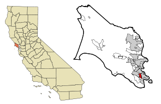
Strawberry is a census-designated place (CDP) and an unincorporated district of Marin County, California, United States. It shares a ZIP code (94941) with Mill Valley and falls within its school districts; however, it is considered within the sphere of influence of the town of Tiburon. It is separated from Mill Valley by U.S. Route 101. Its population was 5,447 at the 2020 census.

<span class="mw-page-title-main">Laytonville, California</span> Census-designated place in California, United States

Laytonville is a census-designated place (CDP) in Mendocino County, California, United States. It is located 23 miles (37 km) north-northwest of Willits, at an elevation of 1,670 feet (510 m). The population was 1,152 at the 2020 census, down from 1,227 at the 2010 census.

<span class="mw-page-title-main">Le Grand, California</span> Census-designated place in California, United States

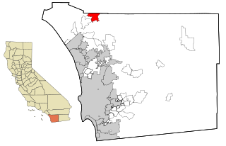
Le Grand is an unincorporated community and census-designated place (CDP) in Merced County, California, United States. Le Grand is 14 miles (23 km) east-southeast of Merced, the county seat at an elevation of 253 feet (77 m). The population was 1,592 at the 2020 census, down from 1,659 at the 2010 census.

<span class="mw-page-title-main">Meadow Valley, California</span> Census-designated place in California, United States

Meadow Valley is a census-designated place (CDP) in Plumas County, California, United States. The population was 453 at the 2020 census, down from 464 at the 2010 census.

<span class="mw-page-title-main">Mira Loma, California</span> Former census-designated place in California, United States

Mira Loma, now officially part of Jurupa Valley, was a census-designated place (CDP) in Riverside County, California, United States. Its population was 21,930 in the 2010 census, up from 17,617 in the 2000 census.

<span class="mw-page-title-main">La Presa, California</span> Census-designated place in California, United States

La Presa is a census-designated place (CDP) in the East County region of San Diego County, California, United States. The population was 34,169 at the 2010 census, up from 32,721 at the 2000 census.

<span class="mw-page-title-main">Pine Valley, California</span> Census-designated place in California, United States

Pine Valley is a community and census-designated place (CDP) in the Cuyamaca Mountains of the Mountain Empire area, in southeastern San Diego County, California. The population was 1,510 at the 2010 census, up from 1,501 at the 2000 census.

<span class="mw-page-title-main">Rainbow, California</span> Census designated place in California, United States

Rainbow is a census designated place (CDP) in northern San Diego County in the U.S. state of California. The population was 1,832 at the 2010 census, down from 2,026 at the 2000 census.

<span class="mw-page-title-main">Amesti, California</span> Census-designated place in California, United States

Amesti is a census-designated place (CDP) in Santa Cruz County, California, United States. The population was 2,637 as of the 2020 United States census.

<span class="mw-page-title-main">Day Valley, California</span> Census-designated place in California, United States

Day Valley is a census-designated place (CDP) in Santa Cruz County, California, United States. The population was 3,409 at the 2010 census.

<span class="mw-page-title-main">Homestead Base, Florida</span> CDP in Florida, United States

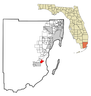
Homestead Base is a census-designated place (CDP) in Miami-Dade County, Florida, United States. The population was 999 at the 2020 census.

<span class="mw-page-title-main">Halaula, Hawaii</span> Census-designated place in Hawaii, United States

Halaula is a census-designated place (CDP) in Hawaiʻi County, Hawaiʻi, United States. The population was 773 at the 2020 census.

<span class="mw-page-title-main">Walker Valley, New York</span> CDP in New York, United States

Walker Valley is a hamlet located in the western part of the Town of Shawangunk in Ulster County, New York, United States, generally thought of as coterminous with the 12588 ZIP code. The population was 853 at the 2010 census.

<span class="mw-page-title-main">Spring Valley Lake, California</span> Census-designated place in California, United States

Spring Valley Lake is a census-designated place in the Victor Valley of the Mojave Desert, within San Bernardino County, California. It is located in Victorville on the Mojave River.

Homestead Valley is a census-designated place in San Bernardino County, California. Homestead Valley sits at an elevation of 3,022 feet (921 m). The 2010 United States census reported Homestead Valley's population was 3,032.

References

  1. "California's 2nd Congressional District - Representatives & District Map". Civic Impulse, LLC. Retrieved March 8, 2013.
  2. 1 2 "2021 U.S. Gazetteer Files: California". United States Census Bureau. Retrieved July 8, 2022.
  3. 1 2 "P1. Race – Tamalpais-Homestead Valley CDP, California: 2020 DEC Redistricting Data (PL 94-171)". U.S. Census Bureau. Retrieved July 8, 2022.
  4. "US Gazetteer files: 2010, 2000, and 1990". United States Census Bureau. 2011-02-12. Retrieved 2011-04-23.
  5. Tamalpais Community Services District website
  6. "Census of Population and Housing". Census.gov. Retrieved June 4, 2016.
  7. "2010 Census Interactive Population Search: CA - Tamalpais-Homestead Valley CDP". U.S. Census Bureau. Archived from the original on July 15, 2014. Retrieved July 12, 2014.
  8. "U.S. Census website". United States Census Bureau . Retrieved 2008-01-31.