Pinole, California

Last updated

City of Pinole
DowntownPinole (cropped).jpg
Downtown Pinole
Flag of Pinole, California.gif
Seal of Pinole, California.png
Motto(s): 
Honoring the past, embracing the future
Contra Costa County California Incorporated and Unincorporated areas Pinole Highlighted.svg
Location of Pinole within California
Usa edcp relief location map.png
Red pog.svg
City of Pinole
Location in the United States
Coordinates: 38°00′16″N122°17′28″W / 38.00444°N 122.29111°W / 38.00444; -122.29111
Country Flag of the United States (23px).png  United States
State Flag of California.svg  California
County Contra Costa
Incorporated June 25, 1903 [1]
Government
  Type council–manager
   Mayor Devin T. Murphy [2]
  Mayor Pro TemMaureen Toms [2]
  City council
City Council [2]
   State Legislature Sen. Nancy Skinner (D) [3]
Asm. Buffy Wicks (D) [4]
   U. S. Congress John Garamendi (D) [5]
Area
[6]
  Total11.76 sq mi (30.46 km2)
  Land5.10 sq mi (13.22 km2)
  Water6.66 sq mi (17.24 km2)  60.79%
Elevation
23 ft (6.4 m)
Population
 (2010)
  Total18,390
  Estimate 
(2019) [7]
19,250
  Density3,771.55/sq mi (1,456.31/km2)
Time zone UTC-8 (PST)
  Summer (DST) UTC-7 (PDT)
ZIP code
94564
Area code(s) 510, 341
FIPS code 06-57288
GNIS feature IDs 277576, 2411428
Website www.ci.pinole.ca.us

Pinole (Spanish for "cornmeal") is a city in Contra Costa County, California, United States. The population was 19,022 [8] at the 2020 census.

Contents

History

Street scene in Pinole, c. 1909 PostcardPinoleCAcirca1909 (cropped).jpg
Street scene in Pinole, c.1909
Bank of Pinole Bank of Pinole (Pinole, CA).JPG
Bank of Pinole

The name derives from "pinole", a Nāhuatl word for a kind of flour made from the ground seeds of maize, chia, and various other grasses, and annual herbs.[ citation needed ] An expedition under Pedro Fages was said to have run out of provisions while exploring the area, and to have been fed pinole by a local village.[ citation needed ] The Spaniards named their camp El Pinole.

In 1823, Ygnacio Martínez, commandant of the Presidio of San Francisco, received a land grant of Rancho El Pinole from the Mexican government. Martinez built a hacienda in Pinole Valley; this is land encompassed by Pinole Valley Park. During the 1850s, Bernardo Fernandez, a Portuguese immigrant, started a trading facility on the shores of San Pablo Bay. He built Fernandez Mansion, a historic building that still stands today at the end of Tennent Avenue. From these early beginnings, a small but thriving community developed into the city of Pinole.

The settlement's growth was stimulated by construction of the Southern Pacific Railroad in 1878 and the establishment of the California Powder Works in nearby Hercules. During this period, this city had an active waterfront and was a regional commercial and banking center. The first post office opened in 1878 when the railroad reached the community. [9] The City of Pinole was incorporated in 1903. [9]

During the post-World War II boom, Pinole and the surrounding area grew rapidly. Construction of Interstate 80 in 1958 stimulated developers to build new housing to satisfy demand, and the town evolved as a suburban bedroom community within the San Francisco/Oakland commuter belt. Much of its original industry was displaced during this time, and the town became predominantly residential.

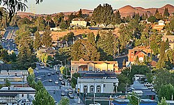
Today, the town is locally known for its "big box" shopping store district along Fitzgerald Drive, and Pinole Vista Shopping Center, which is contiguous with Richmond's Hilltop Area. The downtown area still retains much turn-of-the-century building stock. The city's development agency is working to preserve this historic area as a tourist and community destination.

Geography

Capitol Corridor train along Pinole's coastline on San Pablo Bay Capitol Corridor Pinole.jpg
Capitol Corridor train along Pinole's coastline on San Pablo Bay
Aerial view. Pinole is around the center, and through the partial cloverleaf interchange of Richmond Parkway and Interstate 80 at lower right. Pinole area aerial.jpg
Aerial view. Pinole is around the center, and through the partial cloverleaf interchange of Richmond Parkway and Interstate 80 at lower right.

According to the United States Census Bureau, the city has a total area of 13.6 square miles (35 km2). 5.3 square miles (14 km2) of it is land, and 8.3 square miles (21 km2) of it (60.79%) is water.

The city of Pinole has habitat areas that support the endangered species Santa Cruz Tarweed on the California coastal prairie ecosystem. A colony of this rare plant was discovered during preparation of an Environmental Impact Report for a proposed shopping center on the east side of I-80 in the late 1980s. Subsequently, a plan was developed by the city to conduct replanting of this tarweed on the slopes within the right-of-way of Interstate Highway 80. Also running through is Pinole Creek.

Demographics

Historical population
CensusPop.Note
1890 340
1910 798
1920 96721.2%
1930 781−19.2%
1940 93419.6%
1950 1,14722.8%
1960 6,064428.7%
1970 13,266118.8%
1980 14,2537.4%
1990 17,46022.5%
2000 19,0399.0%
2010 18,390−3.4%
2020 19,0223.4%
U.S. Decennial Census [10]

2010

Bernardo Fernandez House Fernandez Home June 2021.jpg
Bernardo Fernandez House

At the 2010 census Pinole had a population of 18,390. The population density was 1,354.7 inhabitants per square mile (523.1/km2). The racial makeup of Pinole was 8,488 (46.2%) White, 2,458 (13.4%) African American, 147 (0.8%) Native American, 4,220 (22.9%) Asian, 64 (0.3%) Pacific Islander, 1,741 (9.5%) from other races, and 1,272 (6.9%) from two or more races. Hispanic or Latino of any race were 4,005 persons (21.8%). [11]

The census reported that 18,322 people (99.6% of the population) lived in households, 53 (0.3%) lived in non-institutionalized group quarters, and 15 (0.1%) were institutionalized.

There were 6,775 households, 2,202 (32.5%) had children under the age of 18 living in them, 3,500 (51.7%) were opposite-sex married couples living together, 1,012 (14.9%) had a female householder with no husband present, 363 (5.4%) had a male householder with no wife present. There were 325 (4.8%) unmarried opposite-sex partnerships, and 76 (1.1%) same-sex married couples or partnerships. 1,529 households (22.6%) were one person and 676 (10.0%) had someone living alone who was 65 or older. The average household size was 2.70. There were 4,875 families (72.0% of households); the average family size was 3.19.

The age distribution was 3,764 people (20.5%) under the age of 18, 1,674 people (9.1%) aged 18 to 24, 4,325 people (23.5%) aged 25 to 44, 5,779 people (31.4%) aged 45 to 64, and 2,848 people (15.5%) who were 65 or older. The median age was 42.6 years. For every 100 females, there were 90.6 males. For every 100 females age 18 and over, there were 87.0 males.

There were 7,158 housing units at an average density of 527.3 units per square mile (203.6 units/km2),of which 6,775 were occupied, 4,861 (71.7%) by the owners and 1,914 (28.3%) by renters. The homeowner vacancy rate was 1.5%; the rental vacancy rate was 8.0%. 13,210 people (71.8% of the population) lived in owner-occupied housing units and 5,112 people (27.8%) lived in rental housing units.

2000

Corner of Fernandez Ave. and San Pablo Ave. in Downtown Pinole Pinole, CA (28123603107).jpg
Corner of Fernandez Ave. and San Pablo Ave. in Downtown Pinole

At the 2000 census there were 19,039 people in 6,743 households, including 5,057 families, in the city. The population density was 1,413.7/km2 (3,661/sq mi). There were 6,828 housing units at an average density of 507.0/km2 (1,313/sq mi). The racial makeup of the city was 54.39% White, 11.11% Black or African American, 0.57% Native American, 21.71% Asian, 0.37% Pacific Islander, 5.81% from other races, and 6.03% from two or more races. 13.75% of the population were Hispanic or Latino of any race. [12] Of the 6,743 households 34.8% had children under the age of 18 living with them, 56.6% were married couples living together, 13.5% had a female householder with no husband present, and 25.0% were non-families. 20.2% of households were one person and 7.9% were one person aged 65 or older. The average household size was 2.79 and the average family size was 3.23.

The age distribution was 25.0% under the age of 18, 7.8% from 18 to 24, 28.3% from 25 to 44, 26.0% from 45 to 64, and 12.9% 65 or older. The median age was 39 years. For every 100 females, there were 92.4 males. For every 100 females age 18 and over, there were 87.6 males.

The median household income was $62,256 and the median family income was $70,172. Males had a median income of $47,335 versus $38,019 for females. The per capita income for the city was $25,170. About 3.5% of families and 5.0% of the population were below the poverty line, including 5.5% of those under age 18 and 8.0% of those age 65 or over.

Arts and culture

The Pinole Community Players have been performing in Pinole since 1986. [13]

Government

City Hall PinoleCityHall.JPG
City Hall

On February 10, 2019, Pinole has 11,347 registered voters. Of those, 6,365 (56.1%) are registered Democrats, 1,525 (13.4%) are registered Republicans, and 2,993 (26.4%) have declined to state a political party. [14]

Notable people

See also

Related Research Articles

<span class="mw-page-title-main">Cherryland, California</span> Unincorporated Community in California, United States

Cherryland is an unincorporated community and census-designated place (CDP) in Alameda County, California, United States. Cherryland is located between Ashland to the north and the city of Hayward to the south. The population was 15,808 at the 2020 census.

<span class="mw-page-title-main">South Oroville, California</span> Census-designated place in California, United States

South Oroville is a census-designated place (CDP) in Butte County, California, United States. The population was 5,742 at the 2010 census, down from 7,695 at the 2000 census.

<span class="mw-page-title-main">Tara Hills, California</span> Census-designated place in California, United States

Tara Hills is a census-designated place (CDP) in Contra Costa County, California, United States. The population was 5,126 at the 2010 census.

<span class="mw-page-title-main">San Joaquin, California</span> US city, incorporated 1920

San Joaquin is a city in Fresno County, California, United States. The population was 4,001 at the 2010 census, up from 3,270 at the 2000 census. The nearest high school in the area is Tranquillity High School in Tranquillity. San Joaquin is located 11 miles (18 km) southwest of Kerman, at an elevation of 174 feet.

<span class="mw-page-title-main">Willows, California</span> City in California, United States

Willows is a city and the county seat of Glenn County, California, located in the Sacramento Valley region of Northern California. The city is home to regional government offices, including the California Highway Patrol, the California Department of Motor Vehicles, the United States Bureau of Reclamation and the main offices of the Mendocino National Forest, which comprises about one million acres of Federal land located mostly in mountainous terrain west of Willows. The population was 6,293 at the 2020 census.

<span class="mw-page-title-main">Ford City, California</span> Census-designated place in California, United States

Ford City is a census-designated place (CDP) in Kern County, California, United States. Ford City is located 1 mile (1.61 km) north of Taft, at an elevation of 892 feet (272 m). The population was 4,348 at the 2020 census, up from 4,278 at the 2010 census. It is immediately north of Taft, between the huge Midway-Sunset Oil Field to the southwest, and the almost exhausted Buena Vista Oil Field to the northeast. State Route 119 passes east of town from its junction with SR 33 to the south.

<span class="mw-page-title-main">Desert View Highlands, California</span> Census designated place in California, United States

Desert View Highlands is a census-designated place (CDP) in Los Angeles County, California, United States. The population was 2,360 at the 2010 census, up from 2,337 at the 2000 census. It is surrounded by the City of Palmdale.

<span class="mw-page-title-main">Mayflower Village, California</span> Census-designated place in California, United States

Mayflower Village is a census-designated place (CDP) in the San Gabriel Valley, in Los Angeles County, California, United States. The population was 5,515 at the 2010 census, up from 5,081 at the 2000 census. The ZIP Codes serving the community are 91006, which is served by Arcadia and 91016, which is served by Monrovia.

<span class="mw-page-title-main">South San Gabriel, California</span> Census-designated place in California, United States

South San Gabriel is a census-designated place (CDP) in Los Angeles County, California, United States. The population was 8,070 at the 2010 census, up from 7,595 at the 2000 census.

<span class="mw-page-title-main">West Whittier-Los Nietos, California</span> Census-designated place in California, United States

West Whittier-Los Nietos is a census-designated place (CDP) in Los Angeles County, California, near the San Gabriel River and the San Gabriel River (I-605) Freeway. The population was 25,540 at the 2010 census, up from 25,129 at the 2000 census. The census area consists of separate unincorporated communities of Los Nietos and West Whittier.

<span class="mw-page-title-main">Del Rey Oaks, California</span> City in California, United States

Del Rey Oaks is a city in Monterey County, California, United States. It is located just southeast of Seaside, at an elevation of 82 feet (25 m). The population was 1,592 at the 2020 census. Del Rey Oaks is a member of the Association of Monterey Bay Area Governments, a regional government agency.

<span class="mw-page-title-main">La Palma, California</span> City in California, United States

La Palma is a city in Orange County, California, United States. The population was 15,568 at the 2010 Census, up from 15,408 at the 2000 census.

<span class="mw-page-title-main">Meadow Vista, California</span> Census-designated place in California, United States

Meadow Vista is a census-designated place (CDP) in Placer County, California, United States. It is part of the Sacramento–Arden-Arcade–Roseville Metropolitan Statistical Area. The population was 3,217 at the 2010 census, up from 3,096 at the 2000 census.

<span class="mw-page-title-main">East Hemet, California</span> Census-designated place in California, United States

East Hemet is a census-designated place (CDP) in Riverside County, California, United States, located east of Hemet. East Hemet is in an unincorporated area outside the city limits of Hemet. The population was 17,418 at the 2010 census, up from 14,823 at the 2000 census.

<span class="mw-page-title-main">El Cerrito, Riverside County, California</span> Census-designated place in Riverside County, California, United States

El Cerrito is a census-designated place (CDP) in Riverside County, California, United States. It is an unincorporated area mostly surrounded by the city of Corona. The population was 5,100 at the 2010 census, up from 4,590 at the 2000 census.

<span class="mw-page-title-main">La Riviera, California</span> Census-designated place in California, United States

La Riviera is a census-designated place (CDP) in Sacramento County, California, United States. It is part of the Sacramento–Arden-Arcade–Roseville Metropolitan Statistical Area. The population was 10,802 at the 2010 census, up from 10,273 at the 2000 census. La Riviera is a primarily residential neighborhood located between the American River on the North side and Highway 50 on the southern border.

<span class="mw-page-title-main">Highland, California</span> City in California, United States

Highland is a city in San Bernardino County, California, United States. The city's population was 56,999 at the 2020 census.

<span class="mw-page-title-main">La Presa, California</span> Census-designated place in California, United States

La Presa is a census-designated place (CDP) in the East County region of San Diego County, California, United States. The population was 34,169 at the 2010 census, up from 32,721 at the 2000 census.

<span class="mw-page-title-main">Eagle, Idaho</span> City in Idaho, United States

Eagle is a city in Ada County, Idaho 10 miles (16 km) northwest of Boise. The population was 30,346 at the 2020 census.

<span class="mw-page-title-main">Warrensville Heights, Ohio</span> City in Ohio, United States

Warrensville Heights is a city in Cuyahoga County, Ohio, United States. It is an eastern suburb of Cleveland. The population was 13,789 at the 2020 census.

References

  1. "California Cities by Incorporation Date". California Association of Local Agency Formation Commissions. Archived from the original (Word) on February 21, 2013. Retrieved March 24, 2013.
  2. 1 2 3 "City Council". City of Pinole. Retrieved December 8, 2022.
  3. "Senators". State of California. Retrieved March 24, 2013.
  4. "Members Assembly". State of California. Retrieved March 24, 2013.
  5. "California's 5th Congressional District - Representatives & District Map". Civic Impulse, LLC. Retrieved March 9, 2013.
  6. "2019 U.S. Gazetteer Files". United States Census Bureau. Retrieved July 1, 2020.
  7. "Population and Housing Unit Estimates". United States Census Bureau. May 24, 2020. Retrieved May 27, 2020.
  8. "U.S. Census Bureau QuickFacts: Pinole city, California". www.census.gov. Retrieved July 27, 2023.
  9. 1 2 Durham, David L. (1998). California's Geographic Names: A Gazetteer of Historic and Modern Names of the State. Clovis, Calif.: Word Dancer Press. p. 681. ISBN   1-884995-14-4.
  10. "Census of Population and Housing". Census.gov. Retrieved June 4, 2015.
  11. "2010 Census Interactive Population Search: CA - Pinole city". U.S. Census Bureau. Archived from the original on July 15, 2014. Retrieved July 12, 2014.
  12. "U.S. Census website". United States Census Bureau . Retrieved January 31, 2008.
  13. "Pinole Community Players - History: The First Five Years". pinoleplayers.org. Retrieved July 9, 2017.
  14. "CA Secretary of State – Report of Registration – February 10, 2019" (PDF). ca.gov. Retrieved March 12, 2019.
  15. "Ray Kremer at the Society for American Baseball Research". sabr.org. Retrieved July 9, 2023.
  16. Remitz, Ed (December 1, 1972). "Profile: Brad Lackey". Cycle World. Retrieved June 27, 2023.
  17. "Gino Torretta NFL statistics". pro-football-reference.com. Retrieved July 9, 2023.