Belvedere, California

Last updated

Belvedere, California
City of Belvedere
Belvedere around San Francisco Yacht Club.jpg
Belvedere around San Francisco Yacht Club
Flag of Belvedere, California.gif
Marin County California Incorporated and Unincorporated areas Belvedere Highlighted 0605164.svg
Location of Belvedere in Marin County, California.
Usa edcp relief location map.png
Red pog.svg
Belvedere, California
Location in the United States
Coordinates: 37°52′22″N122°27′52″W / 37.87278°N 122.46444°W / 37.87278; -122.46444
Country United States
State California
County Marin
Incorporated December 24, 1896 [1]
Government
  Type Council–manager [2]
  Body
City council [3]
  • James Campbell (Mayor) [4]
  • Steven Block
  • Nancy Kemnitzer
  • James Lynch
  • Sally Wilkinson
   County supervisor District 3
Stephanie Moulton Peters [5]
   State senator Mike McGuire (D) [6]
   Assemblymember Stephanie Nguyen (D) [6]
   U. S. rep. Jared Huffman (D) [7]
Area
[8]
  Total2.41 sq mi (6.23 km2)
  Land0.52 sq mi (1.35 km2)
  Water1.89 sq mi (4.89 km2)  78.42%
Elevation
[9]
36 ft (11 m)
Population
 (2020)
  Total2,126
  Density4,096.34/sq mi (1,580.46/km2)
Time zone UTC-8 (Pacific)
  Summer (DST) UTC-7 (PDT)
ZIP code
94920
Area codes 415/628
FIPS code 06-05164
GNIS feature IDs 1658031, 2409829
Website www.cityofbelvedere.org

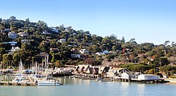
Belvedere is a residential incorporated city located on the San Francisco Bay in Marin County, California, United States. [10] Consisting of two islands and a lagoon, it is connected to the Tiburon Peninsula by two causeways. At the 2020 census, the population was 2,126. The per-capita (per person) income of Belvedere residents in the year 2000 was $250,000, but currently the average income is $283,000, [11] making it one of the highest-income cities in California and the eighth highest-income community in the United States (highest with a population of over 1,000 residents). Belvedere and Tiburon share a post office and the 94920 ZIP code.

Contents

Location

Belvedere Belvedere, California in 2010.jpg
Belvedere
Aerial view of Belvedere and the Tiburon Peninsula San Francisco Bay from the air in May 2010 04.jpg
Aerial view of Belvedere and the Tiburon Peninsula

Belvedere is located at 37°52′22″N122°27′52″W / 37.87278°N 122.46444°W / 37.87278; -122.46444 , [9] about 4 mi (6 km) north of San Francisco.

Belvedere's two islands are Belvedere Island and Corinthian Island. Corinthian Island is shared with Tiburon.

Belvedere Lagoon is situated between the two causeways (Beach Road and San Rafael Avenue) that connect Belvedere Island to the town of Tiburon.

Belvedere has a total area of 2.42 sq mi (6.3 km2), of which 0.54 sq mi (1.4 km2) is land and 1.89 sq mi (4.9 km2) (78%) is water. [12]

History

Belvedere incorporated as a city in 1896. [10] Its first post office was opened in 1897. [10]

Belvedere's City Hall was originally a Presbyterian Church. It was moved to its present location on San Rafael Avenue in 1949. [13]

Actress Vivian Vance, who played Ethel on I Love Lucy , died in Belvedere in 1979 at the age of 70.

In 2017, Belvedere became a twin city with Portofino, Italy. [14]

Houses

Depending on where their homes are located, residents of Belvedere enjoy views of San Francisco, Angel Island, Sausalito, the Golden Gate Bridge, San Francisco and Richardson Bays, and Mount Tamalpais.[ citation needed ]

Houses on Belvedere and Corinthian Islands encompass a range of periods and architectural styles from Victorian to Mediterranean to post-and-beam "mid-century modern". Many are "cliff-hangers". Houses on the Belvedere Lagoon were designed by architects in the 1950s and 1960s. Houses on the lagoon have their own boat docks. Many of the homes on Belvedere and Corinthian Islands have docks with access to San Francisco Bay.

A number of Belvedere homes are listed on the National Register of Historic Places; e.g.,the Valentine Rey House [15] designed by Willis Polk and built in 1893. Notable designers of homes in Belvedere have included Joseph Esherick, Albert Farr, who designed the Belvedere Land Company building [16] and cottages, Henry Gutterson, [17] and Charles Warren Callister.

New construction has become a contentious issue as residents have become frustrated with large projects that they believe are negatively affecting the character of the community.

San Francisco Yacht Club House c 1894 San Francisco Yacht Club House c 1894.JPG
San Francisco Yacht Club House c 1894

Belvedere is a residential community. The nearby town of Tiburon provides services, shops and eateries.

Two yacht clubs are located in Belvedere: the San Francisco Yacht Club and the Corinthian Yacht Club. [18] [19]

Demographics

Historical population
CensusPop.Note
1900 434
1910 48110.8%
1920 61628.1%
1930 500−18.8%
1940 457−8.6%
1950 80075.1%
1960 2,148168.5%
1970 2,59921.0%
1980 2,401−7.6%
1990 2,147−10.6%
2000 2,125−1.0%
2010 2,068−2.7%
2020 2,1262.8%
U.S. Decennial Census [20]

2010

The 2010 United States Census [21] reported that Belvedere had a population of 2,068. Population density was 859.2 people per square mile (331.7 per km2). 1,940 residents (93.8%) were White, 3 (0.1%) African-American, 58 (2.8%) Asian, 7 (0.3%) Pacific Islander, 18 (0.9%) from other races, and 42 (2.0%) from two or more races. 72 residents (3.5%) were Hispanic or Latino of any race.

There were 928 households. 228 (24.6%) had children under the age of 18 living in them, 542 (58.4%) were opposite-sex married couples living together, 54 (5.8%) had a female householder with no husband present, 15 (1.6%) had a male householder with no wife present. There were 27 (2.9%) unmarried opposite-sex partnerships, and 6 (0.6%) same-sex married couples or partnerships.

276 households (29.7%) were made up of individuals, and 187 (20.2%) had someone living alone who was 65 years of age or older. The average household size was 2.23. There were 611 families (65.8% of all households); the average family size was 2.76.

443 residents (21.4%) were under the age of 18, 45 (2.2%) were aged 18 to 24, 277 13.4%) were aged 25 to 44, 650 (31.4%) were aged 45 to 64, and 653 (31.6%) were 65 years of age or older. The median age was 54.0 years. For every 100 females, there were 80.9 males. For every 100 females age 18 and over, there were 78.2 males.

There were 1,045 housing units, with an average density of 434.2 units per square mile (167.6 per km2), of which 695 (74.9%) were owner-occupied and 233 (25.1%) were occupied by renters. The homeowner vacancy rate was 2.1%; the rental vacancy rate was 4.5%. 1,614 residents (78.0% of the population) lived in owner-occupied housing units, and 454 residents (22.0%) lived in rental housing units.

Politics

As of January 2, 2018, Belvedere had 1,425 registered voters. Of these, 587 (41.2%) were registered as Democrats, while 416 (29.2%) were registered as Republicans. 371 (26.0%) declined to state. 51 were registered with other parties. [22]

Twin City

Education

Belvedere is in Reed Union School District and the Tamalpais Union High School District. [24]

See also

Related Research Articles

<span class="mw-page-title-main">Marin County, California</span> County in California, United States

Marin County is located in the northwestern part of the San Francisco Bay Area of the U.S. state of California. As of the 2020 census, the population was 262,231. Its county seat and largest city is San Rafael. Marin County is across the Golden Gate Bridge from San Francisco, and is included in the San Francisco–Oakland–Berkeley, CA Metropolitan Statistical Area.

<span class="mw-page-title-main">Bolinas, California</span> Unincorporated community in California, United States

Bolinas is an unincorporated coastal community and census-designated place in Marin County, California, United States. As of the 2020 census it had a population of 1,483. It is located on the California coast, approximately 13 miles (21 km) northwest of San Francisco, and 27 miles (43 km) by road.

<span class="mw-page-title-main">Larkspur, California</span> City in California, United States

Larkspur is a city in Marin County, California, United States. Larkspur is located 3 miles (4.8 km) south of San Rafael, at an elevation of 43 feet (13 m). As of the 2020 Census, the city's population was 13,064. Larkspur's Police Department is shared with that of the neighboring Corte Madera and town of San Anselmo as the Central Marin Police Authority. Intersecting Larkspur's downtown is Madrone Canyon, a residential area amidst a redwood grove.

<span class="mw-page-title-main">Muir Beach, California</span> Census designated place in California, United States

Muir Beach is a census designated place (CDP), unincorporated community, and beach on the Pacific Ocean. The community is located 16.5 miles (26.6 km) northwest of San Francisco in western Marin County, California, United States. Unlike many other entities in the area, it is not named directly in honor of conservationist John Muir; instead, it was named after Muir Woods National Monument to capitalize on the latter's popularity. The population was 304 at the 2020 census. The community itself flanks the northwest side of the beach.

<span class="mw-page-title-main">San Rafael, California</span> City in California, United States

San Rafael is a city and the county seat of Marin County, California, United States. The city is located in the North Bay region of the San Francisco Bay Area. As of the 2020 U.S. census, the city's population was 61,271, up from 57,713 in 2010.

<span class="mw-page-title-main">Sausalito, California</span> City in California, United States

Sausalito is a city in Marin County, California, United States, located 1.5 miles southeast of Marin City, 8 miles (13 km) south-southeast of San Rafael, and about 4 miles (6 km) north of San Francisco from the Golden Gate Bridge.

<span class="mw-page-title-main">Stinson Beach, California</span> Census-designated place in California, United States

Stinson Beach is an unincorporated community and census-designated place (CDP) in Marin County, California, on the west coast of the United States. Stinson Beach is located 2.5 miles (4 km) east-southeast of Bolinas, at an elevation of 26 feet (8 m). The population of the Stinson Beach CDP was 541 at the 2020 census.

<span class="mw-page-title-main">Strawberry, Marin County, California</span> Census-designated place in California, United States

Strawberry is a census-designated place (CDP) and an unincorporated district of Marin County, California, United States. It shares a ZIP code (94941) with Mill Valley and falls within its school districts; however, it is considered within the sphere of influence of the town of Tiburon. It is largely separated from Mill Valley by U.S. Route 101. Its population was 5,447 at the 2020 census.

<span class="mw-page-title-main">Tiburon, California</span> City in California, United States

Tiburon is an incorporated town in Marin County, California. It is located on the Tiburon Peninsula, which reaches south into the San Francisco Bay. It shares a ZIP code (94920) with the smaller incorporated city of Belvedere, which occupies the southwest part of the peninsula and is contiguous with Tiburon. Tiburon is bordered by Corte Madera to the north and Mill Valley to the west, but is otherwise mostly surrounded by the bay. Besides Belvedere and Tiburon, much of the peninsula is unincorporated, including portions of the north side and the communities of Strawberry and Paradise Cay.

<span class="mw-page-title-main">Brisbane, California</span> City in California, United States

Brisbane is a small city in San Mateo County, California, located on the lower slopes of the San Bruno Mountain. The city is on the northeastern edge of San Mateo County, located immediately south of the San Francisco city limits on the San Francisco Bay. The population was 4,851 as of the 2020 census.

<span class="mw-page-title-main">Foster City, California</span> City in California, United States

Foster City is a city located in San Mateo County, California, United States. The 2020 census put the population at 33,805, an increase of more than 10% over the 2010 census figure of 30,567. Foster City is sometimes considered to be part of Silicon Valley for its local industry and its proximity to Silicon Valley cities. Foster City is one of the United States’ safest cities, with an average of one murder per decade.

<span class="mw-page-title-main">Marin City, California</span> Unincorporated community in California, United States

Marin City is an unincorporated community and census-designated place (CDP) in Marin County, California, United States. As of the 2020 census, it had a population of 2,993, up from 2,666 in 2010. It is located 1.5 miles northwest of downtown Sausalito, 8 miles (13 km) south-southeast of San Rafael, and about 5 miles (8 km) north of San Francisco from the Golden Gate Bridge, at an elevation of 23 feet (7.0 m). Marin City was developed for housing starting in 1942, to accommodate wartime shipyard workers and other migrants to California. Among those were African Americans from the South in the Great Migration, which continued until 1970.

<span class="mw-page-title-main">Richardson Bay</span> Arm of San Francisco Bay

Richardson Bay is a shallow, ecologically rich arm of San Francisco Bay, managed under a Joint Powers Agency of four northern California cities. The 911-acre (369 ha) Richardson Bay Sanctuary was acquired in the early 1960s by the National Audubon Society. The bay was named for William A. Richardson, early 19th century sea captain and builder in San Francisco. It contains both Strawberry Spit and Aramburu Island.

<span class="mw-page-title-main">Belvedere Island</span>

Belvedere Island is a rocky island in the San Francisco Bay in Marin County, California which was formerly separated by a marsh from the mainland, though has since been linked by two spits. Part of the town of Belvedere, California is located on the island.

<span class="mw-page-title-main">Belvedere Lagoon</span> Lagoon in the state of California, United States

Belvedere Lagoon is an artificial lagoon on San Francisco Bay in Belvedere in Marin County, California. Narrow strips of land separate it from Richardson Bay and Raccoon Strait.

<span class="mw-page-title-main">Paradise Cay, California</span> Unincorporated community in California, United States

Paradise Cay, also known as County Service Area No. 29, is an unincorporated enclave, surrounded by the town of Tiburon in Marin County, California, United States, located 2 miles (3 km) south of Point San Quentin at an elevation of 23 feet. The waterfront community lies at the foot of the Tiburon Peninsula south of Corte Madera Creek along the San Francisco Bay. The community is in ZIP code 94920 and area code 415.

<span class="mw-page-title-main">Belvedere Tiburon Library</span>

The Belvedere Tiburon Library is an independent public library serving the communities of Belvedere, Tiburon, and Strawberry, in California and it is operated by The Belvedere Tiburon Library Agency. It has as its mission the provision of library services now and in the future that will encourage and support a literate, enlightened and cultured community.

<span class="mw-page-title-main">San Francisco Yacht Club</span> Yacht club in California

The San Francisco Yacht Club is a yacht club located in Belvedere, California, and the oldest on the Pacific Coast. They were formerly located in San Francisco.

<span class="mw-page-title-main">Corinthian Island</span> Island in California

Corinthian Island is a former island in the San Francisco Bay, that was later attached to the mainland. It is in Marin County, California, by the Tiburon Peninsula. Its coordinates are 37°52′22″N122°27′32″W, and the United States Geological Survey gave its elevation as 72 ft (22 m) in 1981. It appears on a 1950 USGS map of the area.

References

  1. "California Cities by Incorporation Date". California Association of Local Agency Formation Commissions. Archived from the original (Word) on November 3, 2014. Retrieved August 25, 2014.
  2. "City Council". City of Belvedere. Retrieved March 16, 2021.
  3. "City Council". Belvedere, CA. Retrieved January 23, 2015.
  4. "Campbell steps into second stint as Belvedere's mayor". December 23, 2020.
  5. "New Marin supervisor faces full plate of issues". January 3, 2021.
  6. 1 2 "Statewide Database". UC Regents. Archived from the original on February 1, 2015. Retrieved December 15, 2014.
  7. "California's 2nd Congressional District - Representatives & District Map". Civic Impulse, LLC. Retrieved March 8, 2013.
  8. "2020 U.S. Gazetteer Files". United States Census Bureau. Retrieved October 30, 2021.
  9. 1 2 "Belvedere". Geographic Names Information System . United States Geological Survey, United States Department of the Interior.
  10. 1 2 3 Durham, David L. (1998). California's Geographic Names: A Gazetteer of Historic and Modern Names of the State. Clovis, Calif.: Word Dancer Press. p. 601. ISBN   1-884995-14-4.
  11. "Belvedere city, California profile" (PDF). Archived from the original (PDF) on May 18, 2011. Retrieved December 3, 2007.
  12. "U.S. Census website". United States Census Bureau . Retrieved January 31, 2008.
  13. "History". Belvedere, CA. Retrieved February 4, 2015.
  14. "Belvedere California and Portofino Italy twin cities". May 20, 2017. Retrieved February 23, 2018.
  15. "National Register #82002203: Rey House in Belvedere, California". noehill.com. Retrieved December 24, 2015.
  16. "Cupola's Arts and Crafts Architecture - Belvedere Land Company (1 of 3)". www.cupola.com. Retrieved December 24, 2015.
  17. "Henry H. Gutterson - Western Neighborhoods Project - San Francisco History". outsidelands.org. Retrieved December 24, 2015.
  18. "Home - Corinthian Yacht Club". www.cyc.org. Retrieved December 24, 2015.
  19. "San Francisco Yacht Club". Archived from the original on December 1, 2007. Retrieved December 3, 2007.
  20. "Census of Population and Housing". Census.gov. Retrieved June 4, 2015.
  21. "2010 Census Interactive Population Search: CA - Belvedere city". U.S. Census Bureau. Archived from the original on July 15, 2014. Retrieved July 12, 2014.
  22. "Report of Registration as of January 2, 2018, Registration by Political Subdivision by County" (PDF).
  23. "Portofino: Verso il gemellaggio con City of Belvedere, San Francisco". May 20, 2017.
  24. "2020 CENSUS - SCHOOL DISTRICT REFERENCE MAP: Marin County, CA" (PDF). U.S. Census Bureau . Retrieved April 28, 2023. - Text list