History
The village, founded by miners and lumberjacks, is located within the original Rancho Punta de los Reyes Sobrante land grant. [8] It was a stagecoach stop along the north–south route. The village includes the historic Nelson Hotel, which was connected by the old North Pacific Coast Railroad to the Bolinas Station, en route to Point Reyes. [6] That railway ran between Mendocino County and a ferry service to San Francisco at Sausalito. The hotel, with nearby guest houses, was later used by the U.S. Army during both World Wars as barracks. [6] There was also a K-8 school, with about 50 pupils. The schoolhouse was located south of the village towards Bolinas, the nearest town. [6] [9] An early 20th-century pastime was a trip and picnic to the Copper Mine Gulch, which runs through the town. [7]
The town was originally known as Woodville due to its timber industry, although the sawmills closed by the 1870s. [10] The name was changed to Dogtown, as that was a popular name among locals. Until the name change, the hamlet was simply nicknamed "The Dogtown" by Bolinas residents, [9] because the town's residents kept a large number of hunting dogs. [5] The location continues to be labeled "Woodville" on some maps.
The area's economy is agricultural and tourism-based. [5]
Transportation
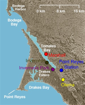
The town is accessible by State Route 1, marked as "Shoreline Highway Road" locally, which runs through the community; north to Point Reyes Station and south to Stinson Beach.
There is limited Marin Transit West Marin Stagecoach (route 61e) bus service between Point Reyes Station, Dogtown, Bolinas, and Mill Valley (with some trips to Marin City). [12] The service provides 4 daily round trips on Wednesdays and Fridays. [12] Some students use it to get to Tamalpais High School on the days it operates; these students are some of the service's key users. [12] There is also service on route 62 from Point Reyes Station to Stinson Beach, with one trip continuing as route 68 from Point Reyes Station to the county seat San Rafael through Lagintas-Forest Knolls, San Anselmo and other communities in the San Geronimo Valley.
Due to the town's geographic isolation, residents are, in most cases, taken to hospitals by helicopter instead of by ambulance in emergencies. [4]

Marin County is located in the northwestern part of the San Francisco Bay Area of the U.S. state of California. As of the 2020 census, the population was 262,231. Its county seat and largest city is San Rafael. Marin County is across the Golden Gate Bridge from San Francisco, and is included in the San Francisco–Oakland–Berkeley, CA Metropolitan Statistical Area.

Bolinas is an unincorporated coastal community and census-designated place in Marin County, California, United States. As of the 2020 census it had a population of 1,483. It is located on the California coast, approximately 13 miles (21 km) northwest of San Francisco, and 27 miles (43 km) by road.

Mill Valley is a city in Marin County, California, United States, located about 14 miles (23 km) north of San Francisco via the Golden Gate Bridge and 52 miles (84 km) from Napa Valley. The population was 14,231 at the 2020 census.

Muir Beach is a census designated place (CDP), unincorporated community, and beach on the Pacific Ocean. The community is located 16.5 miles (26.6 km) northwest of San Francisco in western Marin County, California, United States. Unlike many other entities in the area, it is not named directly in honor of conservationist John Muir; instead, it was named after Muir Woods National Monument to capitalize on the latter's popularity. The population was 304 at the 2020 census. The community itself flanks the northwest side of the beach.

Stinson Beach is an unincorporated community and census-designated place (CDP) in Marin County, California, on the west coast of the United States. Stinson Beach is located 2.5 miles (4 km) east-southeast of Bolinas, at an elevation of 26 feet (8 m). The population of the Stinson Beach CDP was 541 at the 2020 census.

Bolinas Lagoon is a tidal estuary, approximately 1,100 acres (4.5 km2) in area, located in the West Marin region of Marin County, California, United States, adjacent to the town of Bolinas. It is a part of the Greater Farallones National Marine Sanctuary. In 1974, Aubrey Neasham and William Pritchard wrote in support of Bolinas Lagoon as Drake's New Albion landing site.

Area codes 415 and 628 are telephone area codes in the North American Numbering Plan (NANP) for the city of San Francisco and its northern suburbs in Marin County, and the northeast corner of San Mateo County in the U.S. state of California. Area code 415 was one of the eighty-six original North American area codes established in 1947, but modified in geographic configuration later. Area code 628 was assigned in 2015 to form an overlay in that numbering plan area in mitigation of central office prefix exhaustion.

Mount Tamalpais, known locally as Mount Tam, is a peak in Marin County, California, United States, often considered symbolic of Marin County. Much of Mount Tamalpais is protected within public lands such as Mount Tamalpais State Park, the Marin Municipal Water District watershed, and National Park Service land, such as Muir Woods.
The Dipsea Race is a trail running event in California, United States. It is the oldest cross-country trail running event and one of the oldest foot races of any kind in the United States. The 7.5 mile (12 km) long Dipsea Race has been held annually almost every year since November 19, 1905, starting in Mill Valley, and finishing at Stinson Beach, in Marin County. Since 1983, the race has been held on the second Sunday in June. The Dipsea celebrated its 111th running on Sunday, June 12, 2022.

Lagunitas Creek is a 24 miles (39 km)-long northward-flowing stream in Marin County, California. It is critically important to the largest spawning runs of endangered coho salmon in the Central California Coast Coho salmon Evolutionary Significant Unit.

The Marin Hills are a series of steep high ridges and peaks in southern Marin County. They are a part of the long Pacific Coast Ranges mountain system. The centerpoint of these hills is the 2,571 foot Mount Tamalpais near Mill Valley. The hills are bordered to the north by the Santa Rosa Plain and Laguna de Santa Rosa; to the east by San Pablo Bay, the northern arm of San Francisco Bay; to the south by Golden Gate Strait; and to the west by the San Andreas Fault, running through Tomales Bay, Olema Valley, Bolinas Lagoon, and Stinson Beach. Parts of the hills are protected for their scenic beauty by Mount Tamalpais State Park and the Golden Gate National Recreation Area. The many ridges and peaks of these hills form a dramatic backdrop to the Golden Gate Bridge, the San Francisco skyline, and several towns around Richardson Bay when viewed from the south.

The Tamalpais Union High School District or TUHSD provides high school education to students residing in ten elementary districts in central and southern Marin County, California and parts of West Marin. The headquarters are on the property of Redwood High School in Larkspur, California.
Bolinas-Stinson Union School District is a public school district in Marin County, California, with offices in Bolinas, California, USA. As of the 2017–18 school year, the District had 91 students at its Bolinas campus.

Stinson Gulch is a valley in Marin County, California, United States which is associated with a small stream.

Bolinas Ridge is a north-south ridge in southwestern Marin County, California. Much of the western side of the ridge is protected parkland in the Golden Gate National Recreation Area, and the eastern side is watershed lands of the Marin Municipal Water District.
Olema Valley is a gorge formed by the San Andreas Fault in rural west Marin County, Northern California. The valley runs from the southern end of Tomales Bay through Point Reyes Station, the town of Olema, and Dogtown, to the Bolinas Lagoon, which lies between Bolinas and Stinson Beach. It is part of the Golden Gate National Recreation Area.
West Marin is the largest rural region of Marin County, California.
Marin County, California contains many public and private schools and a few higher education institutions.
Rancho Las Baulines was a 8,911-acre (36.06 km2) Mexican land grant in present-day Marin County, California, given in 1846 by Governor Pío Pico to Gregorio Briones. The grant extended around Bolinas Lagoon and encompassed present-day Stinson Beach and Bolinas.
The Marin Conservation League is a environmental organization based in Marin County, California.


