
Año Nuevo State Park is a state park of California, United States, encompassing Año Nuevo Island and Año Nuevo Point, which are known for their pinniped rookeries. Located in San Mateo County, the low, rocky, windswept point juts out into the Pacific Ocean about 55 miles (89 km) south of San Francisco and the Golden Gate. Año Nuevo State Natural Reserve, formerly a separate unit of the California state park system, was merged into Año Nuevo State Park in October 2008. The coastal geographic center, or coastal-midpoint of California is located at the Northern end of this park at N 37°09′58″, W 122°21'40", as the absolute geographic center of California falls at N 37°09′58″, W 119°26′58″W.

The Marin Headlands is a hilly peninsula at the southernmost end of Marin County, California, United States, located just north of San Francisco across the Golden Gate Bridge, which connects the two counties and peninsulas. The entire area is part of the Golden Gate National Recreation Area. The Headlands are famous for their views of the Bay Area, especially of the Golden Gate Bridge.

Montaña de Oro is a state park in Central Coastal California, six miles southwest of Morro Bay and two miles south of Los Osos.
Miramar Beach is a sandy beach in western San Mateo County, California. Miramar Beach is one of the numerous beaches on Half Moon Bay, a Pacific Ocean embayment noted for its surfing and extensive visitation. The marine terrace above the beach itself is situated approximately eight meters above mean sea level, and on this terrace is positioned the small unincorporated community of Miramar, which is a residential setting that also has several coastal visitor serving uses such as restaurant and lodging facilities. A stream named Arroyo de en Medio discharges onto Miramar Beach into the Pacific Ocean.

Tennessee Cove is an embankment off the Pacific Ocean in Marin County, California. It is named after the S.S. Tennessee, a steamship that ran aground near here on March 6, 1853. All 550 passengers climbed safely onto the beach, and fourteen chests of gold were salvaged before the ship broke up. Remnants of the ship can still be seen during low tide during some winter days on the south end of the beach.

The Bigfoot Trail is an unofficial U.S. long-distance hiking trail in northern California. The Bigfoot Trail was originally proposed by Michael Kauffmann in 2009 as a suggested route to navigate the Klamath Mountains from south to north as well as a long-trail to introduce nature lovers to the biodiversity of the Klamath Mountains region. The trail begins in the Yolla Bolly-Middle Eel Wilderness and ends in Redwood National Park at the Pacific Ocean near Crescent City, California. A major focus along the trail is conifer diversity, passing 32 species in 360 miles (580 km). The route crosses six wilderness areas, one National Park, and one State Park. Northwest California's Klamath Mountains foster one of the most diverse temperate coniferous forests on Earth, and this route is intended to be a celebration of that biodiversity.
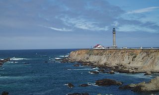
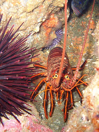
Sea Lion Cove State Marine Conservation Area (SMCA) is a marine protected area that lies onshore, just south of Point Arena in Mendocino County on California’s north central coast. The marine protected area covers 0.22 square miles. Sea Lion Cove SMCA prohibits the commercial and recreational take of invertebrates, algae and other plants, but allows the take of all other species.

Stewarts Point State Marine Reserve (SMR) and Stewarts Point State Marine Conservation Area (SMCA) are two adjoining marine protected areas that extend offshore from about a mile south of Black Point to Fisk Mill Cove, in Sonoma County on California’s north central coast. The marine protected areas cover 25.22 square miles. Stewarts Point SMR prohibits the take of all living marine resources. Stewarts Point SMCA prohibits the take of all living marine resources, except recreational shore based take of marine aquatic plants, marine invertebrates, finfish by hook and line, surf smelt by beach net, and species authorized by Title 14 Section 28.80 by hand-held dip net.

Duxbury Reef State Marine Conservation Area (SMCA) is a marine protected area located about 1 mile (2 km) west of Bolinas in Marin County on California’s north central coast. This marine protected area covers 0.66 square miles (1.7 km2). Duxbury Reef SMCA prohibits the take of all living marine resources, except the recreational take of finfish from shore only and the recreational take of abalone.
Salt Point State Marine Conservation Area (SMCA) is a marine protected area that lies onshore from Fisk Mill Cove and south along Salt Point State Park in Sonoma County on California’s north central coast. The marine protected area covers 3.12 square miles. Salt Point SMCA prohibits the take of all living marine resources, except the recreational take of abalone and finfish.

Montara State Marine Reserve (SMR) and Pillar Point State Marine Conservation Area (SMCA) are two adjoining marine protected areas that extend offshore from Montara to Pillar Point in San Mateo County on California’s north central coast. The combined area of these marine protected areas is 18.42 square miles (47.7 km2), with 11.76 square miles (30.5 km2) in the SMR and 6.66 in the SMCA. Montara SMR prohibits the take of all living marine resources. Pillar Point SMCA prohibits the take of all living marine resources, except the recreational and commercial take of pelagic finfish by trolling or seine, the commercial or recreational take of Dungeness crab by trap and the commercial or recreational take or market squid by hand-held dip net or round haul net.

Greyhound Rock State Marine Conservation Area (SMCA) is one of two adjoining marine protected areas off the coast of San Mateo County and Santa Cruz County, on California's central coast. The area is approximately 55 miles (89 km) south of San Francisco. The SMCA is 11.81 square miles (30.6 km2). Within the SMCA fishing and take of all living marine resources is prohibited except the recreational take of giant kelp, squid, salmon, and other finfish, subject to various conditions. Also permitted is the commercial take of giant kelp, salmon, and squid, subject to various conditions.
San Diego-Scripps Coastal Marine Conservation Area (SMCA) and Matlahuayl State Marine Reserve (SMR) are adjoining marine protected areas that extend offshore from La Jolla in San Diego County on California’s south coast. The two marine protected areas cover 2.51 square miles. San Diego-Scripps Coastal SMCA prohibits the take of all living marine resources except that coastal pelagic species, not including market squid, may be taken recreationally by hook and line. Matlahuayl SMR prohibits the take of all living marine resources.

The Tennessee Valley is a small, undeveloped part of Marin County, near Mill Valley. Historically home to ranches and threatened with the development of a new city, the valley was incorporated into the Golden Gate National Recreation Area in 1972, with additional sections added to the park in 1974. The park contains horse stables, a native-plant nursery, and numerous trails for hiking, biking, and horse riding, including a 1.7-mile, handicap-accessible trail that leads to Tennessee Cove and its beach.
From 1577 to 1580 Sir Francis Drake circumnavigated the world. In 1579 as part of this voyage he landed on the west coast of North America which consequently has drawn the attention of scores of historians, geographers, linguists, anthropologists and other professionals. In addition, many history buffs have sought to locate Drake's New Albion. The established site for Drake's 1579 landing at New Albion is at Drake's Cove in Drakes Bay in Marin County, California. More than a score of ideas for an alternative to Drake's New Albion claim have been put forth which cover the coast from Alaska to Baja California Sur, Mexico. These ideas span the eighteenth through the early twenty-first centuries.

Crystal Cove State Marine Conservation Area (SMCA) is one of a cluster of four adjoining marine protected areas that extend offshore of Newport Beach in Orange County on California’s south coast. The SMCA covers 3.45 square miles of near shore waters. Crystal Cove protects marine life by limiting the removal of marine wildlife from within its borders, including tide pools. Take of all living marine resources is prohibited except: recreational take of finfish by hook-and-line or by spearfishing, and lobster and sea urchin is allowed. Commercial take of coastal pelagic species by round haul net, spiny lobster by trap, and sea urchin is allowed.
Dana Point State Marine Conservation Area (SMCA) is one of four adjoining marine protected areas off the coast of Orange County, CA, on California’s South Coast. By itself, the SMCA measures 3.45 square miles. The SMCA protects marine life by limiting the removal of marine wildlife from within its borders, including tide pools. Dana Point SMCA prohibits take of living marine resources except: only the following species may be taken recreationally below the mean lower low tide line only: finfish by hook-and-line or by spearfishing, and lobster and sea urchin. The commercial take of coastal pelagic species by round haul net, and spiny lobster and sea urchin only is allowed.

Laguna Beach State Marine Reserve (SMR) and Laguna Beach State Marine Conservation Area (SMCA) are two adjoining marine protected areas that extend offshore of Laguna Beach in Orange County on California’s south coast. The SMR covers 6.27 square miles, and the SMCA covers an additional 3.44 square miles. These two MPAs are part of a four-MPA complex on the coast of southern Orange County. Each protects marine life by prohibiting or limiting the removal of marine wildlife from within its borders.
Upper Newport Bay State Marine Conservation Area (SMCA) is a marine protected area in Newport Bay in Orange County and the South Coast region of Southern California. It extends inland/northeast from the Pacific Coast Highway crossing of the bay, within the city of Newport Beach.

Yerba Buena Cove was a cove on San Francisco Bay where the Mexican pueblo of Yerba Buena was located. It lay between Clarks Point to the north and Rincon Point to the south. The beach of the cove was set back as far as what is now Montgomery Street between Clay and Washington Streets.
