
Bolinas is an unincorporated coastal community and census-designated place in Marin County, California, United States. As of the 2020 census it had a population of 1,483. It is located on the California coast, approximately 13 miles (21 km) northwest of San Francisco, and 27 miles (43 km) by road.

Stinson Beach is an unincorporated community and census-designated place (CDP) in Marin County, California, on the west coast of the United States. Stinson Beach is located east-southeast of Bolinas, right across the channel that terminates the bay mouth bar of the Bolinas Lagoon. at an elevation of 26 feet (8 m). The population of the Stinson Beach CDP was 541 at the 2020 census.

Muir Woods National Monument is a United States National Monument managed by the National Park Service and named after naturalist John Muir. It is located on Mount Tamalpais near the Pacific coast in southwestern Marin County, California. The Monument is part of the Golden Gate National Recreation Area, and is 12 miles (19 km) north of San Francisco. It protects 554 acres (224 ha), of which 240 acres (97 ha) are old growth coast redwood forests, one of a few such stands remaining in the San Francisco Bay Area.

Bolinas Lagoon is a tidal estuary, approximately 1,100 acres (4.5 km2) in area, located in the West Marin region of Marin County, California, United States, adjacent to the town of Bolinas. It is a part of the Greater Farallones National Marine Sanctuary. In 1974, Aubrey Neasham and William Pritchard wrote in support of Bolinas Lagoon as Drake's New Albion landing site.

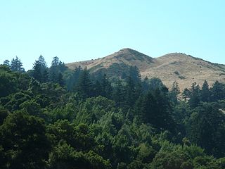
Mount Tamalpais, known locally as Mount Tam, is a peak in Marin County, California, United States, often considered symbolic of Marin County. Much of Mount Tamalpais is protected within public lands such as Mount Tamalpais State Park, the Marin Municipal Water District watershed, and National Park Service land, such as Muir Woods.
The Dipsea Race is a trail running event in California, United States. It is the oldest cross-country trail running event and one of the oldest foot races of any kind in the United States. The 7.5 mile (12 km) long Dipsea Race has been held annually almost every year since November 19, 1905, starting in Mill Valley, and finishing at Stinson Beach, in Marin County. Since 1983, the race has been held on the second Sunday in June. The Dipsea celebrated its 111th running on Sunday, June 12, 2022.
Windy Hill Open Space Preserve is a regional park located in San Mateo County, California and operated by the Midpeninsula Regional Open Space District (MROSD). It is readily identifiable from the flatlands of the South Bay, as it is the only "naked" part of the peninsula range.

The Golden Gate National Recreation Area (GGNRA) is a U.S. National Recreation Area protecting 82,116 acres (33,231 ha) of ecologically and historically significant landscapes surrounding the San Francisco Bay Area. Much of the park is land formerly used by the United States Army. GGNRA is managed by the National Park Service and is the second-most visited unit of the National Park system in the United States, with more than 15.6 million visitors in 2022. It is also one of the largest urban parks in the world, with a size two-and-a-half times that of the consolidated city and county of San Francisco.

Lagunitas Creek is a 24-mile-long (39 km) northward-flowing stream in Marin County, California. It is critically important to the largest spawning runs of endangered coho salmon in the Central California Coast Coho salmon Evolutionary Significant Unit.

The Marin Hills are a series of steep high ridges and peaks in southern Marin County. They are a part of the long Pacific Coast Ranges mountain system. The centerpoint of these hills is the 2,571 foot Mount Tamalpais near Mill Valley. The hills are bordered to the north by the Santa Rosa Plain and Laguna de Santa Rosa; to the east by the San Pablo Bay, the northern arm of San Francisco Bay; to the south by the Golden Gate Strait; and to the west by the San Andreas Fault, running through Tomales Bay, Olema Valley, Bolinas Lagoon, and Stinson Beach. Parts of the hills are protected for their scenic beauty by Mount Tamalpais State Park and the Golden Gate National Recreation Area. The many ridges and peaks of these hills form a dramatic backdrop to the Golden Gate Bridge, the San Francisco skyline, and several towns around Richardson Bay when viewed from the south.

The Tamalpais Union High School District or TUHSD provides high school education to students residing in ten elementary districts in central and southern Marin County, California and parts of West Marin. The headquarters are on the property of Redwood High School in Larkspur, California.

Dogtown is an unincorporated community in the rural West Marin region of coastal Marin County, California in the San Francisco Bay Area's North Bay. It lies at an elevation of 187 feet. With a population of 30, the town is located beside the Golden Gate National Recreation Area and Point Reyes National Seashore, in the Olema Valley west of the Bolinas Ridge mountain range.
Pike County Gulch is a coastal valley in Marin County, California, United States, which is associated with a small stream. It is located between Wilkins Gulch and Audubon Canyon.

Stinson Gulch is a valley in Marin County, California, United States which is associated with a small stream.
Olema Valley is a gorge formed by the San Andreas Fault in rural west Marin County, Northern California. The valley runs from the southern end of Tomales Bay through Point Reyes Station, the town of Olema, and Dogtown, to the Bolinas Lagoon, which lies between Bolinas and Stinson Beach. It is part of the Golden Gate National Recreation Area.
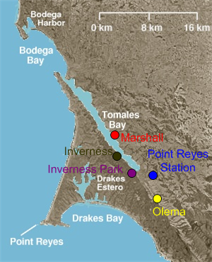
West Marin is the largest region of Marin County, California, which is also rural.
Pine Gulch Creek is a 7.6-mile-long (12.2 km) south-flowing stream in western Marin County, California, United States which empties into Bolinas Lagoon.
Marin County, California contains many public and private schools and a few higher education institutions.
Tamalpais Valley is an unincorporated community in Marin County, California.
The Marin County Department of Parks and Open Space, consisting of the Marin County Parks and Landscape Division and the Marin County Open Space District, is a parks governing body in Marin County, California overseen by the Marin County Board of Supervisors. The current director and general manager is Max Korten.


