Related Research Articles

Bonita is a village in Morehouse Parish, Louisiana, United States. The population was 335 at the 2000 census. It is part of the Bastrop Micropolitan Statistical Area.
KIQI is a commercial AM radio station in San Francisco, California. It is owned by Multicultural Broadcasting and airs a Spanish-language talk radio format. KIQI 1010 AM is simulcast on KATD 990 AM in the Sacramento Valley. Most shows are paid brokered programming where the hosts purchase time on the station and may advertise their companies and services. KIQI and KATD carry Oakland Athletics baseball games in Spanish. The station's studios and offices are located near the Civic Center in San Francisco.
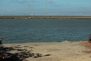
Westpoint Slough is the largest of several sloughs feeding into Redwood Creek in San Mateo County, California, United States. This slough is surrounded by extensive undisturbed marshlands including Greco Island, which forms its northern boundary. The channel of Westpoint Slough contains considerable mudflat areas; moreover, both the marshes and mudflats offer considerable habitat area for local and migratory wildlife, especially birds.
Edwards Stadium is the track and field and soccer venue for the California Golden Bears, the athletic teams of the University of California, Berkeley.
Pier 41 is a ferry terminal on Fisherman's Wharf in San Francisco. The former headquarters of Blue & Gold Fleet, their box offices are now located at Pier 39.
Fluvius Innominatus or Central Creek is a creek in Richmond and El Cerrito, California, in western Contra Costa County. There is one main source and a secondary unnamed tributary. The creek drains into Hoffman Marsh and then flows into the bay through Point Isabel Regional Shoreline's Hoffman Channel. However, before the area was developed and as early as 1899 the creek had 11 sources which stretched far higher into the Berkeley Hills.
Hoffman Channel is a waterway in Richmond, California connecting San Francisco Bay with Hoffman Marsh and Fluvius Innominatus creek which drain directly into the channel. The channel is part of Point Isabel Regional Shoreline, the largest dog park in the United States and serves a swimming are for these animals. Hoffman Channel is adjacent to Point Isabel promontory and was formerly a sandy beach on its south shore.

Richmond Inner Harbor is a deepwater body of water in Richmond, California.
Hoffman Marsh is a wetlands on San Francisco Bay in Richmond, California. The marsh has been protected within Eastshore State Park, and adjacent to Point Isabel Regional Shoreline. The marsh is an important nesting ground for wildfowl and stopping ground on the Pacific Flyway, as it is one of only a handful of undestroyed wetlands in the Bay Area. It borders Point Isabel Regional Shoreline and Interstate 80.
Centissima Reef is the reef which surrounds Sears Rock west of Rodeo Beach in the Pacific Ocean off Marin County, California. Some early reports refer to Centissima Rock and Sears Rock as separate sub-surface navigation hazards, but present-day nautical charts show Sears Rock as part of the larger Centissima Reef.

A seagull intersection or continuous green T-intersection is a type of three-way road intersection, usually used on high traffic volume roads and dual carriageways. This form of intersection is popular in Australia and New Zealand, and sometimes used in the United States and other countries.

Año Nuevo State Marine Conservation Area (SMCA) is one of two adjoining marine protected areas off the coast of San Mateo and Santa Cruz Counties, on California’s central coast. The area is approximately 55 miles south of San Francisco. The SMCA is 11.07 square miles. Except for limited taking of giant kelp, all living marine resources are protected.

Duxbury Reef State Marine Conservation Area (SMCA) is a marine protected area located about 1 mile (2 km) west of Bolinas in Marin County on California’s north central coast. This marine protected area covers 0.66 square miles (1.7 km2). Duxbury Reef SMCA prohibits the take of all living marine resources, except the recreational take of finfish from shore only and the recreational take of abalone.

Montara State Marine Reserve (SMR) and Pillar Point State Marine Conservation Area (SMCA) are two adjoining marine protected areas that extend offshore from Montara to Pillar Point in San Mateo County on California’s north central coast. The combined area of these marine protected areas is 18.42 square miles (47.7 km2), with 11.76 square miles (30.5 km2) in the SMR and 6.66 in the SMCA. Montara SMR prohibits the take of all living marine resources. Pillar Point SMCA prohibits the take of all living marine resources, except the recreational and commercial take of pelagic finfish by trolling or seine, the commercial or recreational take of Dungeness crab by trap and the commercial or recreational take or market squid by hand-held dip net or round haul net.
Upright Channel Park is a former unit of the Washington State Park System consisting of 20 acres (8.1 ha) of island, beach, and tidelands on Upright Channel in the northwest corner of Lopez Island. The park was not listed as a Washington State Parks property as of March 2014. San Juan County assumed management of the property per a Memorandum of Understanding in May 2014.

Greyhound Rock State Marine Conservation Area (SMCA) is one of two adjoining marine protected areas off the coast of San Mateo County and Santa Cruz County, on California's central coast. The area is approximately 55 miles (89 km) south of San Francisco. The SMCA is 11.81 square miles (30.6 km2). Within the SMCA fishing and take of all living marine resources is prohibited except the recreational take of giant kelp, squid, salmon, and other finfish, subject to various conditions. Also permitted is the commercial take of giant kelp, salmon, and squid, subject to various conditions.

Charleston Slough is a former Leslie salt pond that is now reverting to marsh on the western shore of San Francisco Bay.
Bonita Creek is a stream in the city of Newport Beach, Orange County, California. It flows for about 3 miles (4.8 km) northwest from the San Joaquin Reservoir to its confluence with the San Diego Creek near Upper Newport Bay.

Bird Island is an island in San Francisco Bay. It is in San Mateo County, California. Its coordinates are 37°33′04″N122°14′13″W, and the United States Geological Survey gave its elevation as 7 ft (2.1 m) in 1998. It appears on a 2012 USGS map of the area.
Simms Island is a former marsh island in San Francisco Bay; it is now entirely surrounded by land. It is in Marin County, California. Its coordinates are 37°57′33″N122°30′18″W, and the United States Geological Survey gave its elevation as 13 ft (4.0 m) in 1981. It appears in a 1954 USGS map of the region.
References
| | This Marin County, California–related article is a stub. You can help Wikipedia by expanding it. |
| | This article about transportation in California is a stub. You can help Wikipedia by expanding it. |