San Mateo is a city in San Mateo County, California, approximately 20 miles (32 km) south of San Francisco, and 31 miles (50 km) northwest of San Jose. San Mateo had an estimated 2017 population of 104,748.

Yerba Buena Island sits in the San Francisco Bay between San Francisco and Oakland, California. The Yerba Buena Tunnel runs through its center and connects the western and eastern spans of the San Francisco–Oakland Bay Bridge. It has had several other names over the decades: Sea Bird Island, Wood Island, and Goat Island. The island is named after the town of Yerba Buena, which was named for the plant of the same name that was abundant in the area. The plant's English and Spanish common name, Yerba buena, is an alternate form of the Spanish hierba buena, generally used to describe local species of the mint family.

The Intracoastal Waterway (ICW) is a 3,000-mile (4,800 km) inland waterway along the Atlantic and Gulf of Mexico coasts of the United States, running from Boston, Massachusetts, southward along the Atlantic Seaboard and around the southern tip of Florida, then following the Gulf Coast to Brownsville, Texas. Some sections of the waterway consist of natural inlets, saltwater rivers, bays, and sounds, while others are artificial canals. It provides a navigable route along its length without many of the hazards of travel on the open sea.
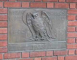
The Bohemian Club is a private club with two locations: a city clubhouse in the Union Square district of San Francisco, California, and the Bohemian Grove, a retreat north of the city in Sonoma County. Founded in 1872 from a regular meeting of journalists, artists and musicians, it soon began to accept businessmen and entrepreneurs as permanent members, as well as offering temporary membership to university presidents and military commanders who were serving in the San Francisco Bay Area. Today, the club has a diverse membership of many local and global leaders, ranging from artists and musicians to businessmen.

Half Moon Bay State Beach is a 4-mile (6 km) stretch of protected beaches in the state park system of California, USA, on Half Moon Bay. From north to south it comprises Roosevelt, Dunes, Venice, and Francis Beaches. The 181-acre (73 ha) park was established in 1956.

The Houston Ship Channel, in Houston, Texas, is part of the Port of Houston, one of the US's busiest seaports. The channel is the conduit for ocean-going vessels between Houston-area terminals and the Gulf of Mexico, and it serves an increasing volume of inland barge traffic.

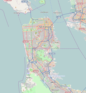
The Port of San Francisco is a semi-independent organization that oversees the port facilities at San Francisco, California, United States. It is run by a five-member commission, appointed by the Mayor and approved by the Board of Supervisors. The Port is responsible for managing the larger waterfront area that extends from the anchorage of the Golden Gate Bridge, along the Marina district, all the way around the north and east shores of the city of San Francisco including Fisherman's Wharf and the Embarcadero, and southward to the city line just beyond Candlestick Point. In 1968 the State of California, via the California State Lands Commission for the State-operated San Francisco Port Authority, transferred its responsibilities for the Harbor of San Francisco waterfront to the City and County of San Francisco / San Francisco Harbor Commission through the Burton Act AB2649. All eligible State port authority employees had the option to become employees of the City and County of San Francisco to maintain consistent operation of the Port of San Francisco.
Richardson Bay is a shallow, ecologically rich arm of San Francisco Bay, managed under a Joint Powers Agency of four northern California cities. The 911-acre (369 ha) Richardson Bay Sanctuary was acquired in the early 1960s by the National Audubon Society. The bay was named for William A. Richardson, early 19th century sea captain and builder in San Francisco.

Middle Harbor Shoreline Park (MHSP) is located on San Francisco Bay and the Port of Oakland entrance channel, west of downtown Oakland, California. It is owned and operated by the Port of Oakland. The park entrance is at the intersection of 7th and Middle Harbor Streets. It is open seven days a week from 8 a.m. to dusk.
Roberts Regional Recreation Area (RRRA) is an area adjacent to Redwood Regional Park located in Alameda County next to Oakland, CA and is part of the East Bay Regional Parks (EBRPD). It is across Skyline Drive from the City of Oakland's Joaquin Miller Park. Kaiser Aluminum and Chemical Corp. adopted Roberts Park in 1979, under the newly-developed Adopt-a-Park program, which promised continued funding. This was the first park in EBRPD to be so adopted.
Castro Rocks are several rocks in Richmond, California protruding from the waters in San Francisco Bay between Castro Point and Red Rock Island.The rocks lie almost directly under the Richmond-San Rafael Bridge (I-580). The rocks are named after Don Víctor Castro a local rancho-era land owner.

Strawberry Lagoon is an inlet within Richardson Bay, Marin County, California, United States. This location, particularly on Strawberry Spit, is a winter haul-out area for the Harbor seal. Pressures of urban development at Strawberry Point along with increases in small boat traffic have diminished the use of this lagoon for seal haul out, noted as early as 1990.

Richmond Inner Harbor is a deepwater body of water in Richmond, California. The harbor lies between Ferry Point and Point Isabel, between the mainland and Brooks Island in western Contra Costa County along the East Bay's northern East Shore. The harbor provides excellent protection as it lies protected by Brooks Island an extensive breakwater inside the already protected San Francisco Bay. The harbour connects to the Sante Fe Channel and its chanellets in addition to the Richmond Marina Bay and Campus Bay. Baxter Creek and Meeker Slough Creek's mouths and deltas drain into the harbor.

Año Nuevo State Marine Conservation Area (SMCA) is one of two adjoining marine protected areas off the coast of San Mateo and Santa Cruz Counties, on California’s central coast.The area is approximately 55 miles south of San Francisco. The SMCA is 11.07 square miles. Except for limited taking of giant kelp, all living marine resources are protected.

Tamalpais Valley is an unincorporated community in Marin County, California.

The Stannard Rock Light, completed in 1883, is a lighthouse located on a reef that was the most serious hazard to navigation on Lake Superior. The exposed crib of the Stannard Rock Light is rated as one of the top ten engineering feats in the United States. It is 24 miles (39 km) from the nearest land, making it the most distant lighthouse in the United States. It was one of the "stag stations", manned only by men, and had the nickname "The Loneliest Place in the World".

Coast Guard Air Station San Francisco is a United States Coast Guard Air Station located 13 miles south of downtown San Francisco, California at the San Francisco International Airport in an unincorporated area of San Mateo County. The air station sits adjacent to the airport which consists of its own ramp, one hangar an administration building and several other support structures.

Blossom Rock was a serious navigational hazard to sailing ships entering or leaving San Francisco Bay in the 19th Century. It was formally reported by Captain F. Beechey of the Royal Navy ship HMS Blossom in 1827.