
Stinson Beach is a census-designated place in Marin County, California, on the west coast of the United States. Stinson Beach is located 2.5 miles (4 km) east-southeast of Bolinas, at an elevation of 26 feet. The population of the Stinson Beach CDP was 632 at the 2010 census.

Bolinas Bay is a small bay, approximately 5 miles (8 km) wide, on the Pacific coast of California in the United States. It is in Marin County, north of the Golden Gate, approximately 15 miles (25 km) northwest of San Francisco. The town of Bolinas is at its shore.

Bolinas Lagoon is a tidal estuary, approximately 1,100 acres (4.5 km2) in area, located in the West Marin region of Marin County, California, United States, adjacent to the town of Bolinas. It is a part of the Greater Farallones National Marine Sanctuary and is considered to be among the possible landing spots of Sir Francis Drake on the west coast of North America in 1579.

The Marin Islands are the two small islands, named East Marin and West Marin, in San Rafael Bay, an embayment of San Pablo Bay in Marin County, California.

The Golden Gate National Recreation Area (GGNRA) is a U.S. National Recreation Area protecting 82,027 acres (33,195 ha) of ecologically and historically significant landscapes surrounding the San Francisco Bay Area. Much of the park is land formerly used by the United States Army. GGNRA is managed by the National Park Service and is the most visited unit of the National Park system in the United States, with more than 15 million visitors a year. It is also one of the largest urban parks in the world, with a size two-and-a-half times that of the consolidated city and county of San Francisco.
Richardson Bay is a shallow, ecologically rich arm of San Francisco Bay, managed under a Joint Powers Agency of four northern California cities. The 911-acre (369 ha) Richardson Bay Sanctuary was acquired in the early 1960s by the National Audubon Society. The bay was named for William A. Richardson, early 19th century sea captain and builder in San Francisco.

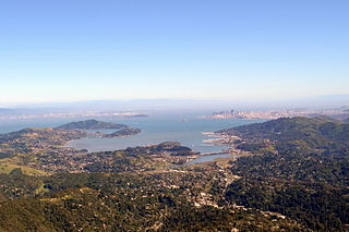
The Marin Hills are a series of steep high ridges and peaks in southern Marin County. They are a part of the long Pacific Coast Ranges mountain system. The centerpoint of these hills is the 2,571 foot Mount Tamalpais near Mill Valley. The hills are bordered to the north by the Santa Rosa Plain and Laguna de Santa Rosa; to the east by San Pablo Bay, the northern arm of San Francisco Bay; to the south by Golden Gate Strait; and to the west by the San Andreas Fault, running through Tomales Bay, Olema Valley, Bolinas Lagoon, and Stinson Beach. Parts of the hills are protected for their scenic beauty by Mount Tamalpais State Park and the Golden Gate National Recreation Area. The many ridges and peaks of these hills form a dramatic backdrop to the Golden Gate Bridge, the San Francisco skyline, and several towns around Richardson Bay when viewed from the south.

Dogtown is an unincorporated community in the rural West Marin region of coastal Marin County, California in the San Francisco Bay Area's North Bay. It lies at an elevation of 187 feet. With a population of 30, the town is located beside the Golden Gate National Recreation Area and Point Reyes National Seashore, in the Olema Valley west of the Bolinas Ridge mountain range.
Copper Mine Gulch is a valley in Marin County, California, United States, which is associated with a small stream.

Wilkins Gulch is a valley in western Marin County, California, United States, located northwest of Pike County Gulch. It is associated with a small stream.
Pike County Gulch is a coastal valley in Marin County, California, United States, which is associated with a small stream. It is located between Wilkins Gulch and Audubon Canyon.

Stinson Gulch is a valley in Marin County, California, United States which is associated with a small stream.

Kent Island is a small island in Marin County, California. In 1964 it was proposed for large-scale development including a hotel and marina, but the plan was defeated in 1967. The island is now included in the Greater Farallones National Marine Sanctuary.

Bolinas Ridge is a north-south ridge in southwestern Marin County, California. Much of the western side of the ridge is protected parkland in the Golden Gate National Recreation Area, and the eastern side is watershed lands of the Marin Municipal Water District.
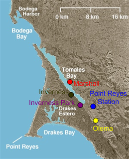
Olema Valley is a gorge formed by the San Andreas Fault in rural west Marin County, Northern California. The valley runs from the southern end of Tomales Bay through Point Reyes Station, the town of Olema, and Dogtown, to the Bolinas Lagoon, which lies between Bolinas and Stinson Beach. It is part of the Golden Gate National Recreation Area.
West Marin is the largest rural region of Marin County, California.
Pine Gulch Creek is a 7.6-mile-long (12.2 km) south-flowing stream in western Marin County, California, United States which empties into Bolinas Lagoon.

L. Martin Griffin, widely known as Marty Griffin, is an American environmentalist and conservationist in Northern California and author of the book Saving the Marin–Sonoma Coast. He has also been a doctor, director of the Sonoma Developmental Center, head of the Marin Audubon Society, board member of the Marin Municipal Water District, and owner of Hop Kiln Winery in Sonoma County.
The Marin County Department of Parks and Open Space, consisting of the Marin County Parks and Landscape Division and the Marin County Open Space District, is a parks governing body in Marin County, California overseen by the Marin County Board of Supervisors. The current director and general manager is Max Korten.


