Millerton, Marin County, California

Last updated
Millerton
Unincorporated community
California Locator Map with US.PNG
Red pog.svg
Millerton
Location in California
Usa edcp location map.svg
Red pog.svg
Millerton
Millerton (the US)
Coordinates: 38°06′33″N122°50′44″W / 38.10917°N 122.84556°W / 38.10917; -122.84556 Coordinates: 38°06′33″N122°50′44″W / 38.10917°N 122.84556°W / 38.10917; -122.84556
Country United States
State California
County Marin County
Elevation [1] 43 ft (13 m)
Area codes 415/628

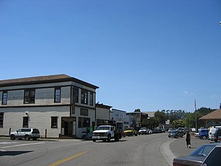
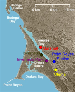
Millerton is a small unincorporated community in Marin County, California. [1] It is located 3.5 miles (5.6 km) northwest of Point Reyes Station, [2] at an elevation of 43 feet (13 m). [1] Millerton is near Point Reyes Station. The community is in ZIP code 94929 and area codes 415 and 628.

Unincorporated area Region of land not governed by own local government

In law, an unincorporated area is a region of land that is not governed by a local municipal corporation; similarly an unincorporated community is a settlement that is not governed by its own local municipal corporation, but rather is administered as part of larger administrative divisions, such as a township, parish, borough, county, city, canton, state, province or country. Occasionally, municipalities dissolve or disincorporate, which may happen if they become fiscally insolvent, and services become the responsibility of a higher administration. Widespread unincorporated communities and areas are a distinguishing feature of the United States and Canada. In most other countries of the world, there are either no unincorporated areas at all, or these are very rare; typically remote, outlying, sparsely populated or uninhabited areas.
Marin County, California County in California, United States

Marin County is a county located in the San Francisco Bay Area of the U.S. state of California. As of the 2010 census, the population was 252,409. Its county seat is San Rafael. Marin County is included in the San Francisco-Oakland-Hayward, CA Metropolitan Statistical Area across the Golden Gate Bridge from San Francisco.

California State of the United States of America

California is a state in the Pacific Region of the United States. With 39.6 million residents, California is the most populous U.S. state and the third-largest by area. The state capital is Sacramento. The Greater Los Angeles Area and the San Francisco Bay Area are the nation's second and fifth most populous urban regions, with 18.7 million and 9.7 million residents respectively. Los Angeles is California's most populous city, and the country's second most populous, after New York City. California also has the nation's most populous county, Los Angeles County, and its largest county by area, San Bernardino County. The City and County of San Francisco is both the country's second-most densely populated major city after New York City and the fifth-most densely populated county, behind only four of the five New York City boroughs.

The name honors James Miller, owner of a wharf at the site. [2]

Related Research Articles

Millerton may refer to the following places:

Point Reyes Station, California Census-designated place in California, United States

Point Reyes Station is a small unincorporated town located in western Marin County, California. Point Reyes Station is located 13 miles (21 km) south-southeast of Tomales, at an elevation of 39 feet (12 m). Point Reyes Station is located along State Route 1 and is a gateway to the Point Reyes National Seashore, an extremely popular national preserve. About 350 people live in the town. It is also the name of a census-designated place (CDP) in northern California covering the unincorporated town and surrounding countryside, with a total CDP population of 848.

Tomales Bay

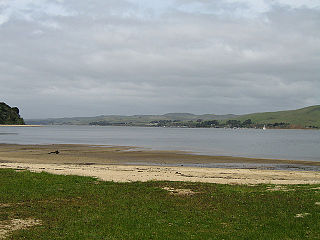
Tomales Bay is a long, narrow inlet of the Pacific Ocean in Marin County in northern California in the United States. It is approximately 15 miles (25 km) long and averages nearly 1.0 miles (1.6 km) wide, effectively separating the Point Reyes Peninsula from the mainland of Marin County. It is located approximately 30 miles (48 km) northwest of San Francisco. The bay forms the eastern boundary of Point Reyes National Seashore. Tomales Bay is recognized for protection by the California Bays and Estuaries Policy. On its northern end it opens out onto Bodega Bay, which shelters it from the direct current of the Pacific. The bay is formed along a submerged portion of the San Andreas Fault.

Area codes 415 and 628 Californian telephone area code for San Francisco and its northern suburbs in Marin County

Area codes 415 and 628 are California telephone area codes for San Francisco and its northern suburbs in Marin County, and the northeast corner of San Mateo County.

Olema, California Unincorporated community in California, United States

Olema is an unincorporated community in Marin County, California. It is located on Olema Creek 2.25 miles (3.6 km) south-southeast of Point Reyes Station, at an elevation of 69 feet.

Tomales Bay State Park

Tomales Bay State Park is a California state park in Marin County, California. It consists of approximately 2,000 acres (8 km²) divided between two areas, one on the west side of Tomales Bay and the other on the east side. The main area, on the west, is part of the Point Reyes peninsula, and adjacent to Point Reyes National Seashore, which is operated by the U.S. National Park Service. The park is approximately 40 miles (64 km) north of San Francisco.

Marshall, California Unincorporated community in California, United States

Marshall is an unincorporated community in Marin County, California. It is located on the northeast shore of Tomales Bay 6 miles (9.7 km) south of Tomales, at an elevation of 25 feet.

Inverness Park, California Unincorporated community in California, United States

Inverness Park is a small unincorporated community in Marin County, California. It is located 1 mile (1.6 km) west-southwest of Point Reyes Station, at an elevation of 148 feet.

Sir Francis Drake Boulevard

Sir Francis Drake Boulevard is an east–west arterial road in Marin County, California, running from the trailhead for Point Reyes Lighthouse at the end of the Point Reyes Peninsula to Interstate 580 just west of the Richmond-San Rafael Bridge. It is a main thoroughfare through the communities of Inverness, Point Reyes Station, Olema, Lagunitas-Forest Knolls, San Geronimo, Woodacre, Fairfax, San Anselmo, Ross, Kentfield, Greenbrae, and Larkspur. The road overlaps State Route 1 between Point Reyes Station and Olema.

Millerton was the original county seat of Fresno County, that was formed in 1856 when the county was larger than today. The county comprised its current area and all of what became Madera County and parts of what are today San Benito, Tulare, Kings, Inyo, and Mono counties.

Dogtown, Marin County, California Unincorporated community in California, United States

Dogtown is an unincorporated community in the rural West Marin region of coastal Marin County, California in the San Francisco Bay Area's North Bay. It lies at an elevation of 187 feet. With a population of 30, the town is located beside the Golden Gate National Recreation Area and Point Reyes National Seashore, in the Olema Valley west of the Bolinas Ridge mountain range.

McNears Beach, California Unincorporated community in California, United States

McNears Beach is an unincorporated community on San Pablo Bay in Marin County, California.

The West Marin Citizen was a weekly newspaper based in Point Reyes Station, California, that covered the western region of Marin County. After a pilot edition, the paper published its first issue on July 5, 2007. In the following years through April 2015, the newspaper engaged in a two-paper competition for limited readership and advertising dollars in a rural area where both were relatively scarce.

Bivalve, California Unincorporated community in California, United States

Bivalve is an unincorporated community in Marin County, California. It is located on the Northwestern Pacific Railroad 2 miles (3.2 km) northwest of Point Reyes Station, at an elevation of 43 feet.

Five Brooks, California Unincorporated community in California, United States

Five Brooks is an unincorporated community in Marin County, California. It is located on Olema Creek 5.25 miles (8.4 km) south-southeast of Point Reyes Station, at an elevation of 194 feet.

Garcia is a former settlement in Marin County, California. It was located on the Northwestern Pacific Railroad 2 miles (3.2 km) east of Point Reyes Station.

Point Reyes (former settlement), California Former settlement in California, United States

Point Reyes is a former settlement in Marin County, California. It was located 7.25 miles (12 km) north-northeast of Point Reyes Lighthouse, at an elevation of 79 feet. Point Reyes still appeared on maps as of 1947.

Tocaloma, California Unincorporated community in California, United States

Tocaloma is an unincorporated community in Marin County, California. It is located on the Northwestern Pacific Railroad 3 miles (4.8 km) east-southeast of Point Reyes Station, at an elevation of 75 feet. By vehicle, it is near the McIsaac's ranch on Sir Francis Drake Boulevard just east of the ascent to the ridge before Olema.

References

  1. 1 2 3 U.S. Geological Survey Geographic Names Information System: Millerton, Marin County, California
  2. 1 2 Durham, David L. (1998). California's Geographic Names: A Gazetteer of Historic and Modern Names of the State. Clovis, Calif.: Word Dancer Press. p. 663. ISBN   1-884995-14-4.