
Jerome John Garcia was an American singer-songwriter and guitarist, best known for his work as the lead guitarist and as a vocalist with the band Grateful Dead, which came to prominence during the counterculture era in the 1960s. Although he disavowed the role, Garcia was viewed by many as the leader or "spokesman" of the group.

Winterhaven is a census-designated place (CDP) in Imperial County, California. Winterhaven is 6.5 miles (10 km) east of Pilot Knob, The population was 394 at the 2010 census, down from 529 at the 2000 census. It is part of the El Centro, CA Metropolitan Area. North of Interstate 8 and bordering Yuma, Arizona, the town is partly in the Fort Yuma Indian Reservation. The Colorado River marks the town's eastern border.

Fairfax is an incorporated town in Marin County, California, United States. Fairfax is located 3.25 miles (5.2 km) west-northwest of San Rafael, at an elevation of 115 feet. The population is 7,441 at the 2010 census. Fairfax is the only town in America that holds a Green Party majority in the town council.

American Canyon is a city located in southern Napa County, California, 35 miles (56 km) northeast of San Francisco in the San Francisco Bay Area. The 2010 census reported the city's population at 19,454. Its ZIP Code is 94503, and its area code is 707. It is in the Pacific Time time zone and observes Daylight-Saving Time. The city was incorporated in 1992. American Canyon is known as America's sweatiest city.

East Blythe is a former census-designated place (CDP) and unincorporated community in Riverside County, California, United States. The 2000 census population was three.

Jeffrey Jason Garcia is a former American football and Canadian football quarterback. After attending high school and junior college in Gilroy, California, Garcia played college football at San Jose State University.
Aaron Garcia is a former professional American football quarterback who played nineteen seasons in the Arena Football League (AFL). He played college football at Washington State University before transferring to California State University, Sacramento, and was in the AFL for 19 seasons, from 1995 to 2014. After retiring from the AFL, Garcia was named the head coach of the Las Vegas Outlaws in September 2014, and was formally introduced as the head coach of the Outlaws on October 11, 2014. Garcia is married to Bryn Garcia and has four children, Gigi, Bella, Anthony and Christian.

Garberville is a census-designated place in Humboldt County, California. It is located on the South Fork of the Eel River 52 miles (84 km) south-southeast of Eureka, at an elevation of 535 feet (163 m). The population was 913 at the 2010 United States Census. It is approximately 200 miles (320 km) north of San Francisco, California, and within a fifteen-minute drive to Humboldt Redwoods State Park and a sixty-minute drive to Eureka, the county seat. Garberville is the primary town in the area known as the Mateel Region, consisting of parts of the Mattole and Eel River watersheds in southern Humboldt and northern Mendocino counties.

Plaster City is an unincorporated community in Imperial County in the U.S. state of California. It is located 17 miles (27 km) west of El Centro, at an elevation of 105 feet.
Mount Signal is an unincorporated community located along State Route 98 about 7.5 miles (12.1 km) west of Calexico in the southern part of the Imperial Valley in Imperial County, California. The area is south of Interstate 8 and about 1.7 miles (2.7 km) north of the Mexico border. It lies at an elevation of 13 feet below sea level. This is an agricultural area. There are a few homes and businesses and many irrigation canals and green fields. The Centinela Solar Energy Project is located here. Other nearby communities include Heber, El Centro, and Seeley.
The Garcia River is a river on the northern coast of California, in southern Mendocino County. The river's watershed covers 144 square miles (370 km2) and its mainstem is 44 miles (71 km) long. The watershed receives 45 inches (1,100 mm) of precipitation per year near the coast and 75 inches (1,900 mm) inland. The watershed's elevation ranges from sea level near the ocean to 2,470 feet (750 m) in the Coast Range. The Garcia River empties into the Pacific Ocean just north of Point Arena. This place is called P'da Hau in the Native California Indians' language who reside on the outlet of the coast.
Ogilby is a ghost town in Imperial County, California, United States. Ogilby is located on the Southern Pacific Railroad 42 miles (68 km) east of El Centro, and 3.8 miles (6.1 km) north of Interstate 8 on County Road S34. The name is official for federal use, and a feature ID number of 252950 has been assigned. Ogilby is defined by the US Geological Survey as a populated place at 356 feet (109 m) AMSL elevation. NAD27 latitude and longitude are listed at 32°49′01″N114°50′20″W on the "Ogilby, California" 7.5-minute quadrangle (map). It is included in the Imperial County Air Pollution Control District. It lies at an elevation of 364 feet (111 m).

Uvas Creek is a 29.5-mile-long (47.5 km) mainly southward-flowing stream originating on Loma Prieta peak of the Santa Cruz Mountains, in Santa Clara County, California, United States. The creek descends through Uvas Canyon County Park into Uvas Reservoir near Morgan Hill, and on through Uvas Creek Preserve and Christmas Hill Park in Gilroy. Upon passing U.S. Highway 101 it is known as Carnadero Creek, shortly before the confluence with the Pajaro River at the Santa Clara County - San Benito County boundary.
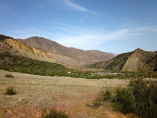
The Garcia Wilderness is a 14,100-acre (57 km2) wilderness area within the Los Padres National Forest in San Luis Obispo County, California.
Mattos is an unincorporated community in Alameda County, California. It is located 1.5 miles (2.4 km) northeast of downtown Newark, at an elevation of 39 feet.
Rancho Seco is an unincorporated community in Kern County, California. It is located 2 miles (3.2 km) south-southwest of Cantil, at an elevation of 2,028 feet (618 m).

Robert Garcia is a Peruvian-American politician who is the mayor of Long Beach, California. He previously represented the First Council District, which includes large areas of downtown, parts of the Port of Long Beach, and some of the densest and most diverse urban areas in the nation.

Little Rock Creek is a 16.7-mile (26.9 km) northwestward-flowing stream in the San Gabriel Mountains and Mojave Desert, within northern Los Angeles County, California.
The Sespe Wilderness is a 219,700-acre (88,900 ha) wilderness area in the eastern Topatopa Mountains and southern Sierra Pelona Mountains, within the Los Padres National Forest (LPNF), in Ventura County, Southern California. The wilderness area is primarily located within the Ojai and Mt. Pinos ranger districts of the LPNF.
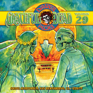
Dave's Picks Volume 29 is a three-CD live album by the rock band the Grateful Dead. It contains the complete concert recorded on February 26, 1977 at Swing Auditorium in San Bernardino, California, and three bonus tracks from February 27, 1977. It was produced as a limited edition of 20,000 copies, and released on February 1, 2019.


