
San Antonio, officially the City of San Antonio, is the seventh-most populous city in the United States, and the second-most populous city in both Texas and the Southern United States, with more than 1.5 million residents. Founded as a Spanish mission and colonial outpost in 1718, the city became the first chartered civil settlement in present-day Texas in 1731. The area was still part of the Spanish Empire, and later of the Mexican Republic. Today it is the state's oldest municipality.

Mission San Antonio de Padua is a Spanish mission established by the Franciscan order in present-day Monterey County, California, near the present-day town of Jolon. It was founded on July 14, 1771, and was the third mission founded in Alta California by Father Presidente Junípero Serra. The mission was the first use fired.tile roofing in Upper California. Today the mission is a parish church of the Diocese of Monterey.

San Antonio Heights is a census-designated place (CDP) in San Bernardino County, California. It is in the northern Pomona Valley and foothills of the San Gabriel Mountains. The area is also part of the city of Upland. San Antonio is commonly mistaken for the one in Texas.
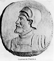
Gaspar de Portolá y Rovira (1723–1786) was a Spanish soldier and administrator in New Spain. As commander of the Spanish colonizing expedition on land and sea that established San Diego and Monterey, Portolá expanded New Spain's Las Californias province far to the north from its beginnings on the Baja California peninsula. Portolá's expedition also was the first European to see San Francisco Bay. The expedition gave names to geographic features along the way, many of which are still in use.

The Pomona Valley is located in the Greater Los Angeles Area between the San Gabriel Valley and San Bernardino Valley in Southern California. The valley is approximately 30 miles east of downtown Los Angeles, which can often be seen from nearby foothills. It ranges from the city of San Dimas from the far west to Rancho Cucamonga to the Far East portion of the valley. The alluvial valley is formed by the Santa Ana River and its tributaries.
Luis Antonio Argüello was the first Californio (native-born) governor of Alta California, and the first to take office under Mexican rule. He was the only governor to serve under the First Mexican Empire and also served as acting governor under the subsequent provisional government, which preceded the First Mexican Republic.
The Cahuilla, also known as ʔívil̃uqaletem or Ivilyuqaletem, are a Native American people of the inland areas of southern California. Their original territory included an area of about 2,400 square miles (6,200 km2). The traditional Cahuilla territory was near the geographic center of Southern California. It was bounded to the north by the San Bernardino Mountains, to the south by Borrego Springs and the Chocolate Mountains, to the east by the Colorado Desert, and to the west by the San Jacinto Plain and the eastern slopes of the Palomar Mountains.

Mount San Antonio, colloquially referred to as Mount Baldy, is the highest peak of the San Gabriel Mountains, and the highest point in Los Angeles County, California. The peak is within the San Gabriel Mountains National Monument and Angeles National Forest. It is the tallest mountain in the Los Angeles metropolitan area. Mount San Antonio's sometimes snow-capped peaks are visible on clear days and dominate the view of the Los Angeles Basin skyline. The peak is pyramid shaped, with a steep south face and a shallower north face. The summit is accessible via a number of connecting ridges along hiking trails from the north, east, south and southwest.

San Antonio Missions National Historical Park is a National Historical Park and part of a UNESCO World Heritage Site preserving four of the five Spanish frontier missions in San Antonio, Texas, USA. These outposts were established by Catholic religious orders to spread Christianity among the local natives. These missions formed part of a colonization system that stretched across the Spanish Southwest in the 17th, 18th, and 19th centuries.
Jolon is an unincorporated community in Monterey County, California, United States. It is located 17 miles (27 km) south of King City, at an elevation of 971 feet. Jolon is located in the San Antonio River valley, west of Salinas Valley. It is in a rural area, approximately six miles from Mission San Antonio de Padua, and is part of Fort Hunter Liggett.
The community of San Antonio Valley, also called San Antonio or San Antone, is located along the Diablo Range in eastern Santa Clara County, California. The locale is bordered by Alameda County to the north and Stanislaus County to the east. The sparsely populated area is located at the junction of San Antonio Valley Road, Mines Road, and Del Puerto Canyon Road. The area includes the San Antonio Valley Ecological Reserve, a 3,282 acre nature preserve created by a Nature Conservancy purchase of land from local rancher, Keith Hurner, and known for its herd of tule elk.

Lake San Antonio is a lake located primarily in southern Monterey County, California, and partially in northern San Luis Obispo County, California. The lake is formed by San Antonio Dam on the San Antonio River. The dam is 202 feet tall and was completed in 1965 under Monterey County District Engineer Loran Bunte Jr. The lake and dam are owned by the Monterey County Water Authority. The lake has a capacity of 350,000 acre feet (430,000,000 m3).

San Antonio is a Caltrain regional rail station located in Mountain View, California. The station has two side platforms serving the two tracks of the Peninsula Subdivision, with a pedestrian tunnel at the south end.

San Timoteo Canyon is a river valley canyon northeast of Redlands, in the far northwestern foothills of the San Jacinto Mountains in the Inland Empire region of Southern California.
Critical Air Medicine is a charter air ambulance service operating from San Diego, California. Critical Air, Inc, the Texas-based rotor-wing operations division of Critical Air Medicine was sold to Air Evac Lifeteam. The remaining fleet consists of 2 CE-421C Golden Eagle prop aircraft operated by 3 full-time pilots.

Mount Baldy or Mt Baldy, formerly Camp Baynham and Camp Baldy, is an unincorporated community in the San Gabriel Mountains, in San Bernardino County near the eastern border of Los Angeles County, in Southern California.
The San Antonio–San Diego Mail Line, also known as the Jackass Mail, was the earliest overland stagecoach and mail operation from the Eastern United States to California in operation between 1857 and 1861. It was created, organized and financed by James E. Birch the head of the California Stage Company. Birch was awarded the first contract for overland service on the "Southern Route", designated Route 8076. This contract required a semi-monthly service in four-horse coaches, scheduled to leave San Antonio and San Diego on the ninth and the 24th of each month, with 30 days allowed for each trip.
Saahatpa was a former Cahuilla settlement in Riverside County. It was a settlement of Juan Antonio's Mountain Cahuilla from 1851 to 1863. It was located in a valley that branched to the northeast from San Timoteo Canyon. The site is marked by California registered landmark #749, and is located at the Brookside Rest Area, on the West 10 Freeway, 3 miles west of the 10/60 junction in modern Beaumont, California.

The 2018 California gubernatorial election was held on November 6, 2018, to elect the next Governor of California. Incumbent Democratic Governor Jerry Brown was ineligible to run for re-election for a third consecutive term due to term limits from the Constitution of California.


