Inverness is an unincorporated community and census-designated place (CDP) located in western Marin County, California. Inverness is located on the southwest shore of Tomales Bay 3.5 miles (5.6 km) northwest of Point Reyes Station, at an elevation of 43 feet. In the 2010 census, the population was 1,304. The community is named after Inverness, Scotland and was named by a Scottish landowner.
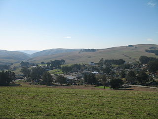
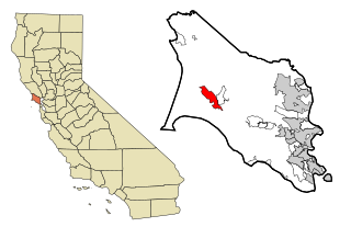
Tomales is a census-designated place (CDP) on State Route 1 in Marin County, California, United States. The population was 204 at the 2010 census. The largest employer in Tomales is Tomales High School, which has a student body of approximately 190.
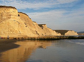
Drakes Bay is a 4-mile (6.4 km) wide bay named so by U.S. surveyor George Davidson in 1875 along the Point Reyes National Seashore on the coast of northern California in the United States, approximately 30 miles (48 km) northwest of San Francisco at approximately 38 degrees north latitude. The bay is approximately 8 miles (13 km) wide. It is formed on the lee side of the coastal current by Point Reyes. The bay is named after Sir Francis Drake and has long been considered Drake's most likely landing spot on the west coast of North America during his circumnavigation of the world by sea in 1579. An alternative name for this bay is Puerto De Los Reyes.

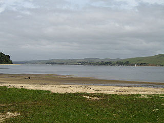
Tomales Bay is a long, narrow inlet of the Pacific Ocean in Marin County in northern California in the United States. It is approximately 15 miles (25 km) long and averages nearly 1.0 miles (1.6 km) wide, effectively separating the Point Reyes Peninsula from the mainland of Marin County. It is located approximately 30 miles (48 km) northwest of San Francisco. The bay forms the eastern boundary of Point Reyes National Seashore. Tomales Bay is recognized for protection by the California Bays and Estuaries Policy. On its northern end it opens out onto Bodega Bay, which shelters it from the direct current of the Pacific. The bay is formed along a submerged portion of the San Andreas Fault.
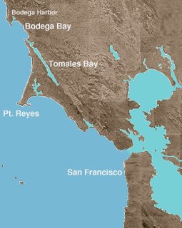
Bodega Bay is a shallow, rocky inlet of the Pacific Ocean on the coast of northern California in the United States. It is approximately 5 mi (8 km) across and is located approximately 40 mi (60 km) northwest of San Francisco and 20 mi (32 km) west of Santa Rosa. The bay straddles the boundary between Sonoma County to the north and Marin County to the south. The bay is a marine habitat used for navigation, recreation, and commercial and sport fishing including shellfish harvesting.
Tomales Bay State Park is a California state park in Marin County, California. It consists of approximately 2,000 acres (8 km²) divided between two areas, one on the west side of Tomales Bay and the other on the east side. The main area, on the west, is part of the Point Reyes peninsula, and adjacent to Point Reyes National Seashore, which is operated by the U.S. National Park Service. The park is approximately 40 miles (64 km) north of San Francisco.

Marshall is an unincorporated community in Marin County, California. It is located on the northeast shore of Tomales Bay 6 miles (9.7 km) south of Tomales, at an elevation of 25 feet.
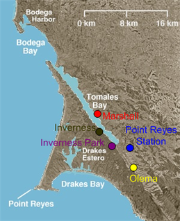
Inverness Park is a small unincorporated community in Marin County, California. It is located 1 mile (1.6 km) west-southwest of Point Reyes Station, at an elevation of 148 feet.

Tomales High School is located in the town of Tomales, California, United States. It is the comprehensive high school of the Shoreline Unified School District. It serves the western Marin and Sonoma County communities, stretching from the towns of Point Reyes Station and Inverness along Tomales Bay, running north past the fishing port of Bodega Bay to the mouth of the Russian River, a distance of nearly 50 miles (80 km), and widening 13 miles (21 km) east from the west coast. Tomales High School draws its students from approximately 450 square miles (1,200 km2). Tomales High School was recognized as a California Distinguished School in 2011.

Marconi is an unincorporated community in Marin County, California. It is located on the northeast shore of Tomales Bay, about seven miles (11 km) south-southeast of the village of Tomales, at an elevation of about 70 feet above sea level. Marconi is located in the area of the town of Marshall, California.
Blakes Landing is an unincorporated community in Marin County, California. It is located on Tomales Bay 3.5 miles (5.6 km) south of Tomales, at an elevation of 0 feet.

Cypress Grove is an unincorporated community in Marin County, California. It is located on the northeast shore of Tomales Bay 5.5 miles (8.9 km) south of Tomales, at an elevation of 13 feet.
Fallon is an unincorporated community in Marin County, California. It is located 2 miles (3.2 km) north of Tomales, at an elevation of 75 feet.
Garcia is a former settlement in Marin County, California. It was located on the Northwestern Pacific Railroad 2 miles (3.2 km) east of Point Reyes Station.
Hamlet is an unincorporated community in Marin County, California. It is located on the northeast shore of Tomales Bay and the Northwestern Pacific Railroad 3 miles (4.8 km) south-southwest of Tomales, at an elevation of 23 feet.
Lairds Landing is an unincorporated community in Marin County, California. It is located on the southwest shore of Tomales Bay 6 miles (9.7 km) south of Tomales, at an elevation of 36 feet.

Nick's Cove is a resort and an unincorporated community in Marin County, California. It is located on the northeast shore of Tomales Bay 3.25 miles (5.2 km) south-southwest of Tomales, at an elevation of 7 feet. Hog Island is in the middle of Tomales Bay, to the west of Nick's Cove, and Point Reyes National Seashore constitutes the western landmass on the opposite side of the bay.
Ocean Roar is an unincorporated community in Marin County, California. It is located on the Northwestern Pacific Railroad 2.25 miles (3.6 km) south-southwest of Tomales, at an elevation of 20 feet.
Reynolds is an unincorporated community in Marin County, California. It is located on the northeast shore of Tomales Bay and on the Northwestern Pacific Railroad 7 miles (11 km) south of Tomales, at an elevation of 30 feet.
Sacramento Landing is an unincorporated community in Marin County, California. It is located on the southwest shore of Tomales Bay 6.5 miles (10 km) south of Tomales, at an elevation of 23 feet.


