
Sonoma County is located in the U.S. state of California. As of the 2020 United States Census, its population was 488,863. Its seat of government and largest city is Santa Rosa. It is to the north of Marin County and the south of Mendocino County. It is west of Napa and Lake Counties.

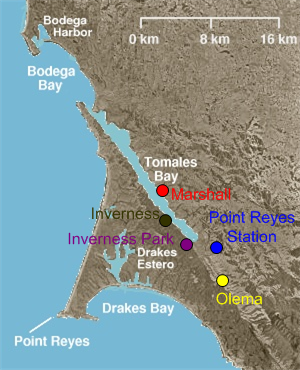
Inverness is an unincorporated community and census-designated place (CDP) in western Marin County, California, United States. It is located on the southwest shore of Tomales Bay 3.5 miles northwest of Point Reyes Station and about 40 miles (65 km) by road northwest of San Francisco, at an elevation of 43 feet. In the 2020 census, the population was 1,379. The community was named by a Scottish landowner after Inverness in Scotland.
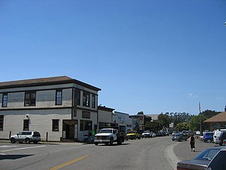
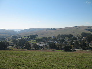
Point Reyes Station is a small unincorporated town in western Marin County, California, United States. Point Reyes Station is located 13 miles (21 km) south-southeast of Tomales, at an elevation of 39 feet (12 m). Point Reyes Station is located along State Route 1 and is a gateway to the Point Reyes National Seashore, an extremely popular national preserve. The Point Reyes Station census-designated place (CDP) covers the unincorporated town and adjacent development to the north, with a total population of 895 as of the 2020 census.
Tomales is a census-designated place (CDP) on State Route 1 in Marin County, California, United States. The population was 187 at the 2020 census.

Coast Miwok are Indigenous people of California that were the second-largest tribe of the Miwok people. Coast Miwok inhabited the general area of modern Marin County and southern Sonoma County in Northern California, from the Golden Gate north to Duncans Point and eastward to Sonoma Creek. Coast Miwok included the Bodega Bay Miwok, or Olamentko (Olamentke), from authenticated Miwok villages around Bodega Bay, the Marin Miwok, or Hookooeko (Huukuiko), and Southern Sonoma Miwok, or Lekahtewutko (Lekatuit). While they did not have an overarching name for themselves, the Coast Miwok word for people, Micha-ko, was suggested by A. L. Kroeber as a possible endonym, keeping with a common practice among tribal groups and the ethnographers studying them in the early 20th Century and with the term Miwok itself, which is the Central Sierra Miwok word for people.

Drakes Estero is an expansive estuary in the Point Reyes National Seashore of Marin County on the Pacific coast of northern California in the United States, approximately 25 miles (40 km) northwest of San Francisco.

Tomales Bay is a long, narrow inlet of the Pacific Ocean in Marin County in northern California in the United States. It is approximately 15 mi (24 km) long and averages nearly 1.0 mi (1.6 km) wide, effectively separating the Point Reyes Peninsula from the mainland of Marin County. It is located approximately 30 mi (48 km) northwest of San Francisco. The bay forms the eastern boundary of Point Reyes National Seashore. Tomales Bay is recognized for protection by the California Bays and Estuaries Policy. On its northern end, it opens out onto Bodega Bay, which shelters it from the direct current of the Pacific. The bay is formed along a submerged portion of the San Andreas Fault.

The North Bay is a subregion of the San Francisco Bay Area, in California, United States. The largest city is Santa Rosa, which is the fifth-largest city in the Bay Area. It is the location of the Napa and Sonoma wine regions, and is the least populous and least urbanized part of the Bay Area. It consists of Marin, Napa, Solano and Sonoma counties.

The Northwestern Pacific Railroad is a 271-mile (436 km) mainline railroad from the ferry connections in Sausalito north to Eureka with a connection to the national railroad system at Schellville. The railroad has gone through a history of different ownership and operators but has maintained a generic name of reference as The Northwestern Pacific Railroad, despite no longer being officially named that. Currently, only a 62-mile (100 km) stretch of mainline from Larkspur to the Sonoma County Airport in Windsor and east to Schellville on the “south end” is operated by Sonoma–Marin Area Rail Transit (SMART), which operates both commuter and freight trains with plans for future extension north to Cloverdale. The “north end” from Willits to Eureka is currently out of service, but saved by 2018 legislation to be converted into the Great Redwood Trail.

The North Pacific Coast Railroad (NPC) was a common carrier 3 ft (914 mm) narrow-gauge steam railroad begun in 1874 and sold in 1902 to new owners who renamed it the North Shore Railroad (California) (NSR) and which rebuilt the southern section into a standard-gauge electric railway.

Marshall is an unincorporated community in Marin County, California. It is located on the northeast shore of Tomales Bay 6 mi (9.7 km) south of Tomales, at an elevation of 25 ft (7.6 m).
The Petaluma Gap is a geographical region in Sonoma County, California which extends in a band from the Pacific Ocean to San Pablo Bay. It is an area of low land 22 to 31 miles wide in the coast ranges of the northern San Francisco Bay Area. The western edge of the gap is located in the coastal lowlands between Bodega Bay and Tomales Bay. The eastern edge of the gap is located at San Pablo Bay around the mouth of the Petaluma River. The city of Petaluma is near the center of the gap.
Hog Island is an island in the wetlands of the Petaluma River in Sonoma County, California, located at 38°09′33″N122°32′18″W near the Marin County line. San Antonio Creek enters the river just west of this island. It is mentioned in a newspaper article from 1914.
West Marin is the largest rural region of Marin County, California.

Training Center Petaluma is a Coast Guard training facility in the northern California counties of Sonoma and Marin. Formerly the installation was the United States Army "Two Rock Station". Approximately 4,000 military students train there each year. It is the only Coast Guard training center or large installation without a major operational component or waterfront.
Walker Creek is a northwest-flowing stream in western Marin County, California, United States. It originates at the confluence of Salmon Creek and Arroyo Sausal, and empties into Tomales Bay south of Dillon Beach, California.

The Marin French Cheese Company is a manufacturer of artisan cheese located in rural west Marin County, California. The company was founded in 1865 by Jefferson Thompson, and produces cheeses under the Marin French Cheese brand name. It is the oldest continually operating cheese manufacturer in the United States.
Rancho Tomales y Baulines was a 9,468-acre (38.32 km2) Mexican land grant in present-day Marin County, California, given in 1836 by Governor Nicolás Gutiérrez to Rafael Garcia. The grant extended south from Point Reyes Station along the Olema Valley and encompassed present day Olema and Garcia.

The Black Point Railroad Bridge is a truss swing bridge spanning the Petaluma River, located in Black Point-Green Point, California.


