
Southern California is a geographic and cultural region that generally comprises California's southernmost counties, and is the second most populous urban agglomeration in the United States. The region is traditionally described as eight counties, based on demographics and economic ties: Imperial, Los Angeles, Orange, Riverside, San Bernardino, San Diego, Santa Barbara, and Ventura. The more extensive 10-county definition, which includes Kern and San Luis Obispo counties, is also used and is based on historical political divisions.

Los Angeles County, officially the County of Los Angeles, in the Los Angeles metropolitan area of the U.S. state of California, is the most populous county in the United States, with more than 10 million inhabitants as of 2017. As such, it is the largest non–state level government entity in the United States. Its population is larger than that of 41 individual U.S. states. It is the third-largest metropolitan economy in the world, with a Nominal GDP of over $700 billion—larger than the GDPs of Belgium, Norway, and Taiwan. It has 88 incorporated cities and many unincorporated areas and, at 4,083 square miles (10,570 km2), it is larger than the combined areas of Delaware and Rhode Island. The county is home to more than one-quarter of California residents and is one of the most ethnically diverse counties in the U.S. Its county seat, Los Angeles, is also California's most populous city and the nation's second largest city with about 4 million people.

Inyo County is a county in the U.S. state of California. As of the 2010 census, the population was 18,546. The county seat is Independence.

San Bernardino County, officially the County of San Bernardino, is a county located in the southern portion of the U.S. state of California, and is located within the Greater Los Angeles area. As of the 2010 U.S. Census, the population was 2,035,210, making it the fifth-most populous county in California, and the 12th-most populous in the United States. The county seat is San Bernardino.

San Anselmo is an incorporated town in Marin County, California, United States. San Anselmo is located 1.5 miles (2.4 km) west of San Rafael, at an elevation of 46 feet. It is located about 20 miles (32 km) north of San Francisco. The town is bordered by San Rafael to the east, Fairfax to the west, and Ross to the south. Mount Tamalpais dominates the view to the south. The population was 12,336 at the 2010 census.

Lucas Valley-Marinwood is a census-designated place (CDP) in Marin County, California, United States. It includes the neighborhoods of Lucas Valley and Marinwood. As of the 2010 census, the population was 6,094.

San Rafael is an affluent city and the county seat of Marin County, California, United States. The city is located in the North Bay region of the San Francisco Bay Area. As of the 2010 census the city's population is 57,713.

San Lucas is a census-designated place (CDP) in Monterey County, California, United States. San Lucas was founded in 1886 and named after the San Lucas Rancho, which was granted in 1842 and named in honor of Saint Luke. The post office was first established in 1892.

Northern California is the northern portion of the U.S. state of California. Spanning the state's northernmost 48 counties its main population centers include the San Francisco Bay Area, the Greater Sacramento area, and the Metropolitan Fresno area. Northern California also contains redwood forests, along with the Sierra Nevada, including Yosemite Valley and part of Lake Tahoe, Mount Shasta, and most of the Central Valley, one of the world's most productive agricultural regions.
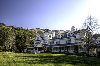
Skywalker Ranch is a movie ranch and workplace of film director, writer and producer George Lucas located in a secluded, yet open area near Nicasio, California, in Marin County. The ranch is located on Lucas Valley Road, named for an early-20th-century landowner in the area, no relation to George Lucas. The Ranch is not open to the public and keeps a low profile from the road. A gated road leads to the ranch.

Area codes 415 and 628 are California telephone area codes for San Francisco and its northern suburbs in Marin County, and the northeast corner of San Mateo County.
Lucas Valley is a valley in Marin County, California, drained to the east into San Pablo Bay by Miller Creek, as well as an unincorporated community in the valley, which forms part of the Lucas Valley-Marinwood CDP.

Nicasio is a census designated place in Marin County, California. It is located 8 miles (13 km) west-southwest of Novato, at an elevation of 194 feet.
Kenneth Michael Goodall, better known as Mike Goodall, was until his death the most active chess tournament organizer in Northern California. He organized and directed the U.S. Chess Championship in 1975, 1984 and 1986, the U.S. Junior Chess Open Championship in 1985, and the U.S. Women's Chess Championship in 1984 and 1986. Most of these events were held on the campus of the University of California, Berkeley. Goodall also organized memorial tournaments at the San Francisco Mechanics' Institute, such as the Stamer Memorial and the Capps Memorial. He also held USCF rated King's Gambit tournaments. The biggest tournament he ever ran was the First Golden Gate Open in 1976 with 468 players.
Renee Humphrey is an American actress who has appeared in both film and television.

Sleepy Hollow is a census-designated place in Marin County, California. It is located 7 miles (11 km) south of downtown Novato, at an elevation of 177 feet. Its population as of the 2010 census is 2,384.

Miller Creek is a 7.6-mile-long (12.2 km) stream in eastern Marin County, California, United States. It originates on Big Rock Ridge and empties into San Pablo Bay east of Marinwood. A middle school called Miller Creek Middle School was named after the creek and is home to 6th, 7th, and 8th graders.

The Dixie School District is a school district located in San Rafael, California, United States that operates four schools in the northern portion of the city: Mary E. Silveira Elementary School in the Marinwood area, Vallecito Elementary School in the Terra Linda area, Dixie Elementary School in the Lucas Valley area, and Miller Creek Middle School in the Marinwood area. All four are California Distinguished Schools.


