
San Francisco Bay is a shallow estuary in the US state of California. It is surrounded by a contiguous region known as the San Francisco Bay Area, and is dominated by the large cities of San Jose, San Francisco and Oakland.
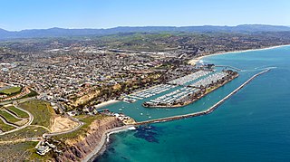
Dana Point is a city located in southern Orange County, California. The population was 33,351 at the 2010 census. It has one of the few harbors along the Orange County coast, and with ready access via State Route 1, it is a popular local destination for surfing.

San Pedro is a community within the city of Los Angeles, California. Formerly a separate city, it consolidated with Los Angeles in 1909. The Port of Los Angeles, a major international seaport, is partially located within San Pedro. The district has grown from being dominated by the fishing industry to become primarily a working-class community within the city of Los Angeles.
Route 110, consisting of State Route 110 and Interstate 110 (I-110), is a state and auxiliary Interstate Highway in the Los Angeles metropolitan area of the U.S. state of California. The entire route connects San Pedro and the Port of Los Angeles with Downtown Los Angeles and Pasadena. The southern segment from San Pedro to Interstate 10 in downtown Los Angeles is signed as I-110, while the northern segment to Pasadena is signed as SR 110. The entire length of I-110, as well as SR 110 south of the Four Level Interchange with US 101, is the Harbor Freeway, and SR 110 north from US 101 to Pasadena is the historic Arroyo Seco Parkway, the first freeway in the western United States. I-110 is one of two 3-digit interstate designations to appear on opposite coasts; I-280 in California and New Jersey is the other.
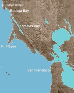
Bodega Bay is a shallow, rocky inlet of the Pacific Ocean on the coast of northern California in the United States. It is approximately 5 mi (8 km) across and is located approximately 40 mi (60 km) northwest of San Francisco and 20 mi (32 km) west of Santa Rosa. The bay straddles the boundary between Sonoma County to the north and Marin County to the south. The bay is a marine habitat used for navigation, recreation, and commercial and sport fishing.
The Pilgrim was an early 19th century American sailing brig. She was immortalized by one of her sailors, Richard Dana, who wrote the classic account Two Years Before the Mast about a 1834-1835 voyage between Massachusetts and California to trade for hides. Pilgrim caught fire and sank at sea in 1856.

San Diego Bay is a natural harbor and deepwater port located in San Diego County, California near the U.S.–Mexico border. The bay, which is 12 miles (19 km) long and 1 to 3 miles wide, is the third largest of the three large, protected natural bays on California's entire 840 miles (1,350 km) long coastline after San Francisco Bay and Humboldt Bay. The highly urbanized land adjacent to the bay includes the city of San Diego and four other cities: National City, Chula Vista, Imperial Beach and Coronado.

Cabrillo National Monument is at the southern tip of the Point Loma Peninsula in San Diego, California, United States. It commemorates the landing of Juan Rodríguez Cabrillo at San Diego Bay on September 28, 1542. This event marked the first time a European expedition had set foot on what later became the West Coast of the United States. The site was designated as California Historical Landmark #56 in 1932. As with all historical units of the National Park Service, Cabrillo was listed on the National Register of Historic Places on October 15, 1966.

Two Harbors, colloquially known as "The Isthmus", is a small unincorporated community island village on Santa Catalina Island, California, with a population of 298. It is the second center of population on the island, besides the city of Avalon. It is mainly a resort village. It has only one restaurant, one hotel and one general store. The village has about 150 permanent residents who live on the isthmus year-round. One notable feature was the one-room schoolhouse which closed in 2014.

Half Moon Bay State Beach is a 4-mile (6 km) stretch of protected beaches in the state park system of California, United States, on Half Moon Bay. From north to south it comprises Roosevelt, Dunes, Venice, and Francis Beaches. The 181-acre (73 ha) park was established in 1956.

Mandalay State Beach is a protected beach in the city of Oxnard, California, United States. Managed by the California Department of Parks and Recreation, the park preserves an area of undeveloped sand dunes and wetlands that was once common along the 16.5-mile-long (26.6 km) coastline of the Oxnard Plain.
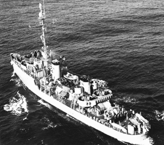
USS Defense (AM-317) was an Auk-class minesweeper acquired by the United States Navy for the dangerous task of removing mines from minefields laid in the water to prevent ships from passing.

The Port of San Francisco is a semi-independent organization that oversees the port facilities at San Francisco, California, United States. It is run by a five-member commission, appointed by the Mayor and approved by the Board of Supervisors. The Port is responsible for managing the larger waterfront area that extends from the anchorage of the Golden Gate Bridge, along the Marina district, all the way around the north and east shores of the city of San Francisco including Fisherman's Wharf and the Embarcadero, and southward to the city line just beyond Candlestick Point. In 1968 the State of California, via the California State Lands Commission for the State-operated San Francisco Port Authority, transferred its responsibilities for the Harbor of San Francisco waterfront to the City and County of San Francisco / San Francisco Harbor Commission through the Burton Act AB2649. All eligible State port authority employees had the option to become employees of the City and County of San Francisco to maintain consistent operation of the Port of San Francisco.

Half Moon Bay is a bay of the Pacific Ocean on the coast of San Mateo County, California. The bay is approximately semi-circular, hence the name half moon, with sea access to the south. Coastal towns located there are Princeton-by-the-Sea, Miramar, El Granada, and the city of Half Moon Bay.
Castro Rocks are several rocks in Richmond, California protruding from the waters in San Francisco Bay between Castro Point and Red Rock Island.The rocks lie almost directly under the Richmond-San Rafael Bridge (I-580). The rocks are named after Don Víctor Castro, a local rancho-era land owner.
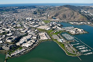
Oyster Point Marina/Park is a 408-berth public marina and 33-acre (13 ha) park located in the city of South San Francisco, California on the western shoreline of San Francisco Bay.

Point San Pablo Harbor is a marina and small community at the far end of Point San Pablo in San Pablo Bay, within Richmond, in Contra Costa County, California. It is located at 1900 Stenmark Drive, Richmond CA 94801.

Richmond Inner Harbor is a deepwater body of water in Richmond, California.

The harborseal, also known as the common seal, is a true seal found along temperate and Arctic marine coastlines of the Northern Hemisphere. The most widely distributed species of pinniped, they are found in coastal waters of the northern Atlantic, Pacific Oceans, Baltic and North Seas.


