Alameda originally occupied a peninsula connected to Oakland.[11] The area was low-lying and marshy, while higher ground was part of one of the largest coastal oak forests in the world. A local band of the Ohlone tribe inhabited the region for more than 3,000 years. They were present at the time of the arrival of the Spanish in the late 18th century. The Ohlone created numerous oyster shell mounds across the peninsula, some as large as 14 feet tall.[12]
Spanish colonists called the area Encinal, meaning "forest of evergreen oak".[13] What is now Alameda, and much of the East Bay was included in the vast Rancho San Antonio granted to Don Luis María Peralta by the Spanish king who claimed California. The grant was later confirmed by the Republic of Mexico after its independence in 1821 from Spain. Over time, the place became known as Bolsa de Encinal or Encinal de San Antonio.[14]
Early California era
The Alameda Shore, painted by Joseph Lee c.1868
The city of Alameda was founded on June 6, 1853, following the Mexican–American War of 1848 and the subsequent acquisition of California by the U.S.
The name Alameda is Spanish for "grove of poplar trees" or "tree-lined avenue"[15] and was chosen in 1853 as city's official name by popular vote.[16]
At the time, Alameda comprised three small settlements:
Alameda — a village at Encinal and High streets
Hibbardsville — ocated at the North Shore ferry and shipping terminal, and
The borders of Alameda were expanded to include the entire island in 1872, incorporating Woodstock into Alameda.[14]
In his autobiography, writer Mark Twain described Alameda as "The Garden of California."[17]
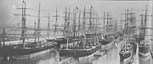
Alameda shipyards at the turn of the 20th century
The first post office opened in 1854.[14] The first school, Schermerhorn School, was opened a year later in 1855 (eventually renamed as Lincoln School). The San Francisco and Alameda Railroad opened the Encinal station in 1864.[14] The early formation of the Park Street Historic Commercial District (or downtown) was centered near the train lines.[18] Encinal's own post office opened in 1876, was renamed West End in 1877, and closed in 1891.[14]
The Croll Building, on the corner of Webster Street and Central Avenue, was the site of Croll's Gardens and Hotel, used as training quarters for some of the most popular fighters in boxing from 1883 to 1914.[20]Jack Johnson and several other champions all stayed and trained here.[21]
The need for expanded shipping facilities and increased flow of current through the estuary led to the dredging of a tidal canal through the marshland between Oakland and Alameda. Construction started in 1874, but it was not completed until 1902, resulting in Alameda becoming an island.[22]
In 1917, a private entertainment park called Neptune Beach was built in the area now known as Crab Cove, which became a major recreation destination in the 1920s and 1930s. Both the American snow cone[23] and the popsicle[24] were first sold at Neptune Beach. The Kewpie doll became the original prize for winning games of chance at the beach, another Neptune Beach innovation.[25][26] The park closed down in 1939.
The Alameda Works Shipyard was one of the largest and best-equipped shipyards in the country. Together with other industrial facilities, it became part of the defense industry buildup before and during World War II, which attracted many migrants from other parts of the United States for the high-paying jobs. In the 1950s, Alameda's industrial and shipbuilding industries thrived along the Alameda Estuary.
In the early 21st century, the Port of Oakland, across the estuary, has become one of the largest ports on the West Coast. Its operators use shipping technologies originally experimented within Alameda. As of March 21, 2006, Alameda is a "Coast Guard City", one of seven then designated in the country. As of 2018, it is one of twenty-one within the country.[27]
Aerial view of Alameda, 1936
In addition to the regular trains running to the Alameda Mole, Alameda was also served by local steam commuter lines of the Southern Pacific (initially, the Central Pacific). Alameda was the site of the Southern Pacific's West Alameda Shops, where all the electric trains were maintained and repaired. These were later adapted as the East Bay Electric Lines. The trains ran to both the Oakland Mole and the Alameda Mole.
In the 1930s Pan American Airways established a seaplane port along with the fill that led to the Alameda Mole, the original home base for the China Clipper flying boat. In 1929, the University of California established the San Francisco Airdrome located near the current Webster Street tube as a public airport. The Bay Airdrome had its gala christening party in 1930. The Airdrome was closed in 1941 when its air traffic interfered with the newly built Naval Air Station Alameda (NAS Alameda).[28]
In the late 1950s, the Utah Construction Company began a landfill beyond the Old Sea Wall and created South Shore.
On February 7, 1973, a USN VoughtA-7E Corsair II fighter jet on a routine training mission from Lemoore Naval Air Station suddenly caught fire 28,000 feet (8,500m) above the San Francisco Bay, crashing into the Tahoe Apartments in Alameda. Eleven people including the pilot died in the crash and fire.[29][30]
Geography
Alameda's nickname is "The Island". Today, the city consists of three major sections:
Alameda Island – The main original section created by dredging a channel between Oakland to the north, with the former Naval Air Station Alameda (NAS Alameda) at the west end of Alameda Island, South Shore along the southern side of Alameda Island,
Bay Farm Island – Part of the mainland proper, and attached to Oakland.
The area of the former NAS is now known as "Alameda Point." The South Shore area is separated from the main part of Alameda Island by a lagoon; the north shore of the lagoon is located approximately where the original south shore of the island was. Alameda Point, Bay Farm Island, and South Shore are largely built on bay fill.
Not all of Alameda Island is part of the City of Alameda; a small portion of a dump site west of the former runway at Alameda Naval Air Station extends far enough into San Francisco Bay that it is over the county line and therefore part of the City and County of San Francisco.[32] Ballena Isle, an even smaller island, is also part of Alameda.
Climate
This region experiences warm (but not hot), dry summers, and cool (but not cold), wet winters. According to the Köppen climate classification system, Alameda has a warm-summer Mediterranean climate, abbreviated "Csb" on climate maps.[33] Annual precipitation is about 22in (560mm), all rain (snow is extremely rare at sea level in the San Francisco Bay Area).
The low-lying island has seen sea-level and groundwater level rise threaten its infrastructure and people not just through flooding events, but through the increased liquefaction risk from more saturated soils. The locations of increasing groundwater-induced risks and flooding risks may be most precise in private insurance company maps.[35]
Alameda, California – Racial and ethnic composition Note: the US Census treats Hispanic/Latino as an ethnic category. This table excludes Latinos from the racial categories and assigns them to a separate category. Hispanics/Latinos may be of any race.
The 2010 United States census[40] reported that Alameda had a population of 73,812. (2015 census estimates place the population at 78,630)
The population density was 3,214.9 inhabitants per square mile (1,241.3/km2). The racial makeup of Alameda was 37,460 (50.8%) White, 23,058 (31.2%) Asian, 4,759 (6.4%) African American, 426 (0.6%) Native American, 381 (0.5%) Pacific Islander, 2,463 (3.3%) from other races, and 5,265 (7.1%) from two or more races. Hispanic or Latino of any race were 8,092 persons (11.0%).
The Census reported that 72,316 people (98.0% of the population) lived in households, 857 (1.2%) lived in non-institutionalized group quarters, and 639 (0.9%) were institutionalized.
There were 30,123 households, out of which 9,144 (30.4%) had children under the age of 18 living in them, 13,440 (44.6%) were opposite-sex married couples living together, 3,623 (12.0%) had a female householder with no husband present, 1,228 (4.1%) had a male householder with no wife present. There were 1,681 (5.6%) unmarried opposite-sex partnerships, and 459 (1.5%) same-sex married couples or same-sex partnerships. 9,347 households (31.0%) were made up of individuals, and 2,874 (9.5%) had someone living alone who was 65 years of age or older. The average household size was 2.40. There were 18,291 families (60.7% of all households); the average family size was 3.06.
The age distribution of the population shows 15,304 people (20.7%) under the age of 18, 5,489 people (7.4%) aged 18 to 24, 21,000 people (28.5%) aged 25 to 44, 22,044 people (29.9%) aged 45 to 64, and 9,975 people (13.5%) who were 65 years of age or older. The median age was 40.7 years. For every 100 females, there were 91.7 males. For every 100 females age 18 and over, there were 88.5 males.
Per capita annual income (in 2013 dollars) in 2009–2013 was $41,340 per the US Census. Median household income in 2009–2013 was $74,606 per the US Census.
There were 32,351 housing units at an average density of 1,409.0 per square mile (544.0/km2), of which 30,123 were occupied, of which 14,488 (48.1%) were owner-occupied, and 15,635 (51.9%) were occupied by renters. The homeowner vacancy rate was 1.1%; the rental vacancy rate was 5.7%. 37,042 people (50.2% of the population) lived in owner-occupied housing units and 35,274 people (47.8%) lived in rental housing units.
2000
Twin Towers Church
As of the census[41] of 2000, there were 72,259 people, 30,226 households, and 17,863 families residing in the city. The population density was 2,583.3/km2 (6,693.4/mi2). There were 31,644 housing units at an average density of 1,131.3/km2 (2,931.2/mi2). The racial makeup of the city was 56.95% White, 6.21% Black or African American, 0.67% Native American, 26.15% Asian, 0.60% Pacific Islander, 3.29% from other races, and 6.13% from two or more races. 9.31% of the population were Hispanic or Latino of any race.
There were 30,226 households, out of which 27.7% had children under the age of 18 living with them, 43.7% were married couples living together, 11.4% had a female householder with no husband present, and 40.9% were non-families. Of all households, 32.2% were made up of individuals, and 9.4% had someone living alone who was 65 years of age or older. The average household size was 2.35 and the average family size was 3.04.
In the city, the age distribution of the population shows 21.5% under the age of 18, 7.0% from 18 to 24, 33.6% from 25 to 44, 24.6% from 45 to 64, and 13.3% who were 65 years of age or older. The median age was 38 years. For every 100 females, there were 92.3 males. For every 100 females age 18 and over, there were 89.5 males.
The median income for a household in the city was $56,285, and the median income for a family was $68,625. Males had a median income of $49,174 versus $40,165 for females. The per capita income for the city was $30,982. About 6.0% of families and 8.2% of the population were below the poverty line, including 11.4% of those under age 18 and 6.1% of those age 65 or over.
There is a large Filipino community; and also a major Portuguese community, from which Tom Hanks' mother came and where Lyndsy Fonseca was raised for some time. Alameda also has a historic Japanese American community and had a small Japanese business district on a portion of Park Street before World War II, when the city's Japanese population was interned. A Japanese Buddhist church is one of the few remaining buildings left of Alameda's pre-war Japanese American community.[42]
A cluster of artisan distilleries, wineries, breweries and tasting rooms along Monarch Street at Alameda Point is now referred to by the City of Alameda as "Spirits Alley".[44] Admiral Maltings also sits in this area, supplying craft brewers and whisky producers, and is the first craft malting house in California.[45]
Photo-realist Robert Bechtle has painted numerous Alameda subjects, including Alameda Gran Torino, which was acquired by SFMOMA in 1974 and remains one of Bechtle's most famous works.[46]
The Altarena Playhouse, which performs comedies, dramas, and musicals, was founded in 1938 and is the longest continuously operating community theater in the San Francisco Bay Area.[48]
Radium is a planned performing arts complex at the former naval air station and has seasonal shows in an outdoor theater.[49]
Festivals
The Fourth of July parade is advertised as the longest in the United States.[50] It features homemade floats, classic cars, motorized living room furniture, fire-breathing dragons, and marching bands.
There are multiple major events when streets in Alameda's historic downtown district are closed to vehicular traffic. Park Street Art and Wine Faire is the biggest and takes place the last weekend of every July with more than 200 artists and vendors. Seasonal events like the spring and winter markets, as well as themed rum, whiskey and hot cocoa strolls are spread out through the year.[51]
The annual Sand Castle and Sculpture Contest takes place in June[52] at the Robert Crown Memorial State Beach, attracting hundreds of participants.[53] The first contest was held in 1967.[54]
Alameda Point Antiques Faire is held on the first Sunday of every month at the former Naval Air Station runways. It is the largest antiques and collectibles show in Northern California, attracting upwards of 10,000 visitors and featuring 800 dealer booths. The faire specializes in items 20 years or older, including furniture, decorations, clothing, jewelry, art, pottery, books, and collectibles.[55]
California Historical Radio Society Museum – set in a 125 year old telephone building, the museum covers electronic communication with artifacts from the late 1800’s on display.[57]
Pacific Pinball Museum – an interactive museum/arcade with a chronological and historical selection of rare and early pinball games including a rotating set of more than 100 playable pinball machines ranging in era from the 1940s to present day located on Webster Street.[58]
Alameda is a charter city governed by a five-member City Council, including the Mayor, who are all elected at large. The City operates under a council-manager system defined by the City Charter,[59] with a professional City Manager overseeing daily administration. The City Manager is responsible for city operations, budget administration, and implementing council policies, distinguishing Alameda from strong-mayor systems often in bigger cities. The City Attorney and City Clerk report directly to the Council.
The budget for the city is greater than $310 million a year as of the 2023-25 biannual budgets planning cycle.[60] The City Treasurer and City Auditor are independently elected.[61] Residents appointed by the Mayor and City Council serve on a range of boards and commissions overseeing major components of the city (for example recreation and parks, library, transportation and planning).[62]
Alameda's government is responsible for a range of municipal services, including public safety, transportation, parks, and land use planning. Rare to a city of its size, it operates its own city-wide electricity utility, Alameda Municipal Power, which has 100% clean electricity[63] and as much as a 48% savings over comparable PG&E rates.[64]
Alameda Free Library
Alameda Free Library
There are three library locations: the Main Library in downtown Alameda, the Bay Farm Island Library and the West End Library. Beyond books, services at the library include events and author talks, computer labs, home delivery of books,[65] as well as e-book, streaming digital media, and audio book catalogs.[66] Historical resources of Alameda's past include local newspaper and magazine archives, high school yearbooks, books by local authors and maps.[67]
In 2000 voters authorized a bond measure to construct a new main library to replace the city's Carnegie Library, damaged during the 1989 Loma Prieta earthquake. The city also received state funds for the new main library and opened the doors to the new facility in November 2006.
Public primary and secondary education in Alameda is the responsibility of the Alameda Unified School District (AUSD), which is legally separate from the City of Alameda government (as is common throughout California). More than 9,000 students are enrolled in the AUSD system across nine elementary, four middle, four high schools.[68] The California Department of Education School Dashboard reports student performance is "green" and above state standards for English, math and college/career preparation.[69]
Alameda's first newspaper, the Encinal, appeared in the 1860s.[71] Following the Encinal, several other papers appeared along geographic lines, and the Daily Argus eventually rose to prominence.[72] Around 1900, the Daily Argus began to fade in importance and east and west papers The Times and The Star combined to take the leading role as the Alameda Times-Star in the 1930s. The Times-Star was sold to the Alameda Newspaper Group in the 1970s. In 1997, the Hills Newspaper chain was bought by Knight Ridder. Between 2001 and 2023, the Alameda Sun ran a local weekly print newspaper.[73]
California State Route 61 runs down city streets from the Posey and Webster Street Tubes, across the Bay Farm Island Bridge, and south to the Oakland Airport. The island is just minutes off Interstate 880 in Oakland. The speed limit for the city is 25 mph (40 km/h) on almost every road.
Water Shuttle – The Oakland Alameda Water Shuttle is pedestrian/bike boat that connects Alameda Landing and Oakland's Jack London Square runs five days a week for free.
BART and Rail – The closest BART stations are Lake Merritt and 12th Street, near the exit to the Posey Tube, and Fruitvale, near the Fruitvale Bridge. BART's long-term plans for a second tunnel include Alameda as a candidate for the first stop on a new East Bay line.[76] The closest Amtrak rail station is Oakland-Jack London Square.
Air –Oakland International Airport abuts the eastern border of Alameda's Bay Farm Island, and includes passenger, freight and private aircraft flights.
Phyllis Diller, television comedian, attended Sunday school at First Presbyterian, married and lived in Alameda at the start of her comedy career in San Francisco in the 1950s.[85]
General James Doolittle, who received the Medal of Honor for his bombing of Japan during World War II; Doolittle was born in Alameda in 1896.[87]
Garrett Eckbo, landscape architect who lived in Alameda as a child, later forming the Bay Area firm of Eckbo, Royston, Williams with Robert Royston and Edward Williams.[88]
Don Perata, former President Pro Tempore of California State Senate, lives in Alameda; once taught at Saint Joseph Notre Dame High, Encinal High, and Alameda High, among other Alameda schools.[110]
Initiated in 1959 as part of President Eisenhower'speople-to-people-movement, whose purpose was to develop better understanding among people from different countries after World War II. Both Alameda and Lidingö are islands with a bridge connecting them to a big city.
1 2 3 4 5 Durham, David L. (1998). California's Geographic Names: A Gazetteer of Historic and Modern Names of the State. Clovis, California: Word Dancer Press. p.592. ISBN1-884995-14-4.
↑ Kulczyk, David. (2009). Death In California – The Bizarre, Freakish, and Just Curious Ways People Die in the Golden State. Craven Street Books. P117 ISBN978-1-884995-57-6
↑ "ISC Alameda Home". Webarchive.loc.gov. Archived from the original on November 9, 2001. Retrieved July 13, 2017.{{cite web}}: CS1 maint: bot: original URL status unknown (link)
This page is based on this Wikipedia article Text is available under the CC BY-SA 4.0 license; additional terms may apply. Images, videos and audio are available under their respective licenses.