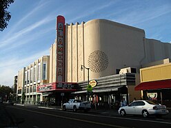
Alameda is a city in Alameda County, California, United States, located in the East Bay region of the Bay Area. The city is built on an informal archipelago in San Francisco Bay, consisting of Alameda Island, Bay Farm Island and Coast Guard Island, along with other smaller islands. As of the 2020 census, the city's population was 78,280.

The North Loop is a neighborhood in the Central community of Minneapolis.

The Key System was a privately owned company that provided mass transit in the cities of Oakland, Berkeley, Alameda, Emeryville, Piedmont, San Leandro, Richmond, Albany, and El Cerrito in the eastern San Francisco Bay Area from 1903 until 1960, when it was sold to a newly formed public agency, AC Transit. The Key System consisted of local streetcar and bus lines in the East Bay, and commuter rail and bus lines connecting the East Bay to San Francisco by a ferry pier on San Francisco Bay, later via the lower deck of the Bay Bridge. At its height during the 1940s, the Key System had over 66 miles (106 km) of track. The local streetcars were discontinued in 1948 and the commuter trains to San Francisco were discontinued in 1958. The Key System's territory is today served by BART and AC Transit bus service.

Rockridge is a residential neighborhood and commercial district in Oakland, California. Rockridge is generally defined as the area east of Telegraph Avenue, south of the Berkeley city limits, west of the Oakland hills and north of the intersection of Pleasant Valley Avenue/51st Street and Broadway. Rockridge was listed by Money Magazine in 2002 as one of the "best places to live".

Alameda Terminal was a railroad station and ferry wharf at the foot and west of present-day Pacific Avenue and Main Street in Alameda, California, on the eastern shore of San Francisco Bay with ferry service to San Francisco. It was built in 1864 and operated by the San Francisco and Alameda Railroad. In 1869, it served as the original west coast terminus of the U.S. First transcontinental railroad, until the opening of Oakland Pier two months later. The western terminus was inaugurated September 6, 1869, when the first Western Pacific through train from Sacramento reached the shores of San Francisco Bay at Alameda Terminal, — thus completing the first transcontinental railroad "from the Missouri river to the Pacific ocean" in accordance with the Pacific Railroad Acts.
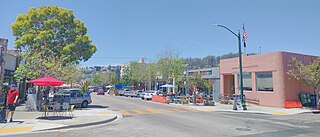
Solano Avenue in Berkeley and Albany, California is a two-mile (3.2 km) long east-west street. Solano Avenue is one of the larger shopping districts in the Berkeley area. Businesses along Solano Avenue cover a wide range, including grocery stores, coffee shops, drugstores, bookstores, antique dealers, apparel outlets, ethnic restaurants and a movie theater.
The Alameda Unified School District serves Alameda, California, United States.

The East Bay Electric Lines were a unit of the Southern Pacific Railroad that operated electric interurban-type trains in the East Bay region of the San Francisco Bay Area. Beginning in 1862, the SP and its predecessors operated local steam-drawn ferry-train passenger service in the East Bay on an expanding system of lines, but in 1902 the Key System started a competing system of electric lines and ferries. The SP then drew up plans to expand and electrify its system of lines and this new service began in 1911. The trains served the cities of Berkeley, Albany, Emeryville, Oakland, Alameda, and San Leandro transporting commuters to and from the large Oakland Pier and SP Alameda Pier. A fleet of ferry boats ran between these piers and the docks of the Ferry Building on the San Francisco Embarcadero.

Downtown Oakland is the central business district of Oakland, California, United States. It is located roughly bounded by both the Oakland Estuary and Interstate 880 on the southwest, Interstate 980 on the northwest, Grand Avenue on the northeast, and Lake Merritt on the east.
Weeks and Day was an American architectural firm founded in 1916 by architect Charles Peter Weeks (1870–1928) and engineer William Peyton Day (1886–1966).
The San Francisco and Alameda Railroad (SF&A) was a short-lived railroad company in the East Bay area of the San Francisco Bay Area. The railroad line opened 1864–1865 from Alameda Terminal on Alameda Island to Hayward, California, with ferry service between Alameda Terminal and San Francisco started in 1864. After being bankrupted by the 1868 Hayward earthquake, it was acquired by a subsidiary of the Central Pacific Railroad in August 1869. Part of the SF&A line between Alameda Terminal and San Leandro served as a portion of the First transcontinental railroad starting in September 1869, while the southern section was abandoned in 1873.

There are nine historic districts in Meridian, Mississippi. Each of these districts is listed on the National Register of Historic Places. One district, Meridian Downtown Historic District, is a combination of two older districts, Meridian Urban Center Historic District and Union Station Historic District. Many architectural styles are present in the districts, most from the late 19th century and early 20th century, including Queen Anne, Colonial Revival, Italianate, Art Deco, Late Victorian, and Bungalow.

Frederick Heath was an American architect responsible for numerous projects in Tacoma, Washington. He worked out of his own office and as a senior partner at architectural firms. He was involved with Spaulding, Russell & Heath, and Heath & Gove. His work included designs for several historic and notable schools, churches, stadiums, and commercial properties.

Alameda Island is an island located in the San Francisco Bay in California. It is south and west of, and adjacent to, Oakland, and across the bay eastward from San Francisco. Located on the island is most of the city of Alameda, a city in Alameda County. A very small western tip of the island's territory is technically part of San Francisco; however, this is uninhabited and is not separately managed. Alameda Island is the most populated island in the continental United States that is not located in the New York City metropolitan area.
Walter Danforth Bliss (1874-1956) was an American architect from California. Many of his buildings are listed on the National Register of Historic Places.

The Downtown Essex Junction Commercial Historic District encompasses the historically railroad-dominated portion of downtown Essex Junction, Vermont. Aligned along the south side of Railroad Avenue and adjacent portions of Main Street, the area underwent most of its development between 1900 and 1940, when Essex Junction served as a major regional railroad hub. The district was listed on the National Register of Historic Places in 2004.

The St. Johnsbury Historic District encompasses much of the historic civic and commercial center of St. Johnsbury, Vermont. Representing a significant expansion of the Railroad Street Historic District and the St. Johnsbury Main Street Historic District, it captures the historical tension and competition between Main Street and Railroad Street for primacy as the town's most important civic and commercial areas. The district was listed on the National Register of Historic Places in 1980.
There are several neighborhoods in the city of Pasadena, California