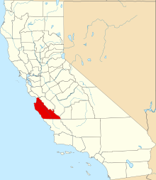
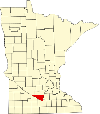
This is intended to be a complete list of the properties and districts on the National Register of Historic Places in Monterey County, California, United States. Latitude and longitude coordinates are provided for many National Register properties and districts; these locations may be seen together in an online map.[1]
There are 63 properties and districts listed on the National Register in the county, including 6 National Historic Landmarks.
Conference complex with 11 contributing properties, established in 1913. Noted for its associations with the YWCA, pioneering female architect Julia Morgan, and the resort industry of the Monterey Peninsula, and for its American Craftsman architecture.[6]
1900 house by noted California architect William Henry Weeks; its design and rare surviving plans document the emergence of his popular Modified Colonial style. Listing also includes an adjacent 1936 rental cottage.[9]
Rare surviving rancho adobe of the Salinas Valley, built c. 1846 and associated with the influential Boronda family.[11] Now the centerpiece of the Boronda Adobe History Center.[12]
1904 Queen Anne house of Frank Buck (1849–1931), a local civic leader in the early 20th century. One of Pacific Grove's few intact large Victorian homes, associated with local architect Robert C. Gass and builder C.E. Hovey.[13] Now a bed & breakfast.[14]
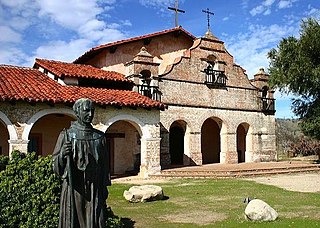
Exemplary church dating to 1793—though extensively reconstructed and renovated beginning in 1884—of a mission established by Junípero Serra in 1770. More properly called Mission San Carlos Borroméo del río Carmelo.[15]
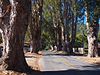
Prominent and locally unusual streetside row of Eucalyptus globulus trees, planted sometime between 1874 and 1881 during the species' peak popularity in California for landscaping.[16]
1936 multi-purpose facility of a Japanese American farming community whose 1942 abandonment and 1944–45 use as a hostel symbolize the loss of civil rights at the beginning and end of Japanese American internment.[17]
Hotel and cottage complex with four contributing properties, established in 1889 and expanded in 1892 and 1905, reflecting Pacific Grove's rapid development as a resort destination.[18]
One of Monterey County's oldest functioning churches, a prominent 1884 Carpenter Gothic church exemplifying a type common to late-19th-century small California towns.[19]
One of the first visitor accommodations on the Carmel-San Simeon Highway, whose rustic ambience shaped recreational development of the Big Sur. Nomination includes five original buildings constructed 1936–1941.[22]
One of the nation's last constructed and last surviving equestrian veterinary complexes of the U.S. Army, active 1941–46, symbolizing the final years of horse-dependent warfare. Now the Marina Equestrian Center.[27]
1887 inn which evolved architecturally and commercially, from a vernacular boarding house serving a religious retreat to a Queen Anne hotel catering to vacationers.[30] Still operating as a bed & breakfast.[31]
Longtime home of poet Robinson Jeffers (1887–1962), featuring a granite masonry house and 40-foot (12m) tower he largely hand built beginning in 1919.[32] Now a non-profit historic attraction known as Tor House and Hawk Tower.[33]
1841 adobe and outbuildings that served as a stagecoach stop on El Camino Real 1848–1880s. Also significant for its prehistoric and historic archaeological resources.[39]
Adobe given a unique Greek Revival façade in the 1850s, when notable American settler Josiah Merritt—co-organizer and first judge of Monterey County—moved in.[41] Now a boutique hotel.[42]
Several dozen buildings dating to Monterey's years as the Spanish and Mexican capital of Alta California and the major European stronghold on the West Coast.[47] District includes Monterey State Historic Park.[48]
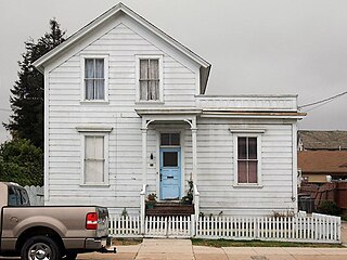
Rare surviving example of the vernacular houses common to California's latter-19th-century settlement, and home 1881–1933 of a notable local lawman.[49]
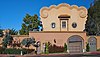
1926 house—whose name means "Forget pain"—noted for its singular use of Mexican vernacular architecture and adherence to the community planning strictures of Pebble Beach.[50]
1925 Tudor Revival house also known as the Flanders Mansion, significant as a work of architect Henry Higby Gutterson and for its innovative construction with precast concrete blocks. Now preserved within Mission Trail Park.[51]
1937 laboratory of marine biologist Ed Ricketts (1897–1948), friend and collaborator of author John Steinbeck and frequent host to Monterey's intelligentsia.[52]
Home 1874–1900 of John T. Porter, an influential local financier and benefactor of Chinese immigrants. Its 1895–99 remodelling is also significant as an early work of architect William Henry Weeks.[58]
House dating to 1867 of one of the first American families to homestead the Big Sur coast, with a New England-style saltbox wing built in 1877. Now part of the Ventana Inn resort.[59]
1891 house of Hiram Corey, one of Monterey County's most successful stock farmers of the late 19th century. Also noted for its exemplary Queen Anne style in a rural setting.[60]
Monterey County's best preserved large ranch dating to a transition period between stock raising and cereal farming, with eight contributing properties built 1865–1888. Also associated with influential local entrepreneur Alberto Trescony (c. 1812–1892).[61]
California's only surviving presidio chapel and Monterey's only surviving 18th-century building, dating to 1794.[63] Also known as the Cathedral of San Carlos Borromeo.
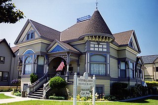
Birthplace and family home of John Steinbeck (1902–1968), inhabited by the author off and on up to 1935. Also noted for its Queen Anne architecture.[66] Now a restaurant and house museum.[67]
Public school whose 1931 auditorium served as Carmel's primary artistic, civic, and social venue. Also noted for its Collegiate Gothic architecture.[70]
1893 house noted for its exemplary Queen Anne architecture and association with Dr. Oliver Smith Trimmer, who helped develop Pacific Grove as its long-serving first mayor.[72]
Nation's only documented remains of a rigid airship, which was launched in 1933 and sank after crash landing in 1935, contributing to the cancellation of the U.S. Navy's rigid airship program.[75]
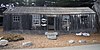
Cabin whose site may yield evidence of an early ethnic community established around 1850 by either Portuguese whalers or Chinese fishermen. Now a museum within Point Lobos State Natural Reserve.[76]
Jolon is a small unincorporated village in southern Monterey County, California. Jolon is located on the San Antonio River Valley, west of Salinas Valley and is entirely surrounded by Fort Hunter Liggett.
This is a list of the National Register of Historic Places listings in Rice County, Minnesota. It is intended to be a complete list of the properties and districts on the National Register of Historic Places in Rice County, Minnesota, United States. The locations of National Register properties and districts for which the latitude and longitude coordinates are included below, may be seen in an online map.
This is a list of the National Register of Historic Places listings in Saint Louis County, Minnesota. It is intended to be a complete list of the properties and districts on the National Register of Historic Places in Saint Louis County, Minnesota, United States. The locations of National Register properties and districts for which the latitude and longitude coordinates are included below, may be seen in an online map.
This is a list of the National Register of Historic Places listings in Stearns County, Minnesota. It is intended to be a complete list of the properties and districts on the National Register of Historic Places in Stearns County, Minnesota, United States. The locations of National Register properties and districts for which the latitude and longitude coordinates are included below, may be seen in an online map.
This is a list of the National Register of Historic Places listings in Crow Wing County, Minnesota. It is intended to be a complete list of the properties and districts on the National Register of Historic Places in Crow Wing County, Minnesota, United States. The locations of National Register properties and districts for which the latitude and longitude coordinates are included below, may be seen in an online map.
This is a list of the National Register of Historic Places listings in Morrison County, Minnesota. It is intended to be a complete list of the properties and districts on the National Register of Historic Places in Morrison County, Minnesota, United States. The locations of National Register properties and districts for which the latitude and longitude coordinates are included below, may be seen in an online map.
This is a list of the National Register of Historic Places listings in Nicollet County, Minnesota. It is intended to be a complete list of the properties and districts on the National Register of Historic Places in Nicollet County, Minnesota, United States. The locations of National Register properties and districts for which the latitude and longitude coordinates are included below, may be seen in an online map.
This is a list of the National Register of Historic Places listings in Itasca County, Minnesota. It is intended to be a complete list of the properties and districts on the National Register of Historic Places in Itasca County, Minnesota, United States. The locations of National Register properties and districts for which the latitude and longitude coordinates are included below, may be seen in an online map.
This is a list of the National Register of Historic Places listings in Le Sueur County, Minnesota. It is intended to be a complete list of the properties and districts on the National Register of Historic Places in Le Sueur County, Minnesota, United States. The locations of National Register properties and districts for which the latitude and longitude coordinates are included below, may be seen in an online map.
This is a list of the National Register of Historic Places listings in Lake County, Minnesota. It is intended to be a complete list of the properties and districts on the National Register of Historic Places in Lake County, Minnesota, United States. The locations of National Register properties and districts for which the latitude and longitude coordinates are included below, may be seen in an online map.
This is a list of the National Register of Historic Places listings in Rock County, Minnesota. It is intended to be a complete list of the properties and districts on the National Register of Historic Places in Rock County, Minnesota, United States. The locations of National Register properties and districts for which the latitude and longitude coordinates are included below, may be seen in an online map.
This is a list of the National Register of Historic Places listings in Cass County, Minnesota. It is intended to be a complete list of the properties and districts on the National Register of Historic Places in Cass County, Minnesota, United States. The locations of National Register properties and districts for which the latitude and longitude coordinates are included below, may be seen in an online map.
This is a list of the National Register of Historic Places listings in Cook County, Minnesota. It is intended to be a complete list of the properties and districts on the National Register of Historic Places in Cook County, Minnesota, United States. The locations of National Register properties and districts for which the latitude and longitude coordinates are included below, may be seen in an online map.
This is a list of the National Register of Historic Places listings in Houston County, Minnesota. It is intended to be a complete list of the properties and districts on the National Register of Historic Places in Houston County, Minnesota, United States. The locations of National Register properties and districts for which the latitude and longitude coordinates are included below, may be seen in an online map.
Rancho Buena Vista was a 8,446-acre (34.18 km2) Spanish land concession in the Salinas Valley, in present day Monterey County, California given in 1795 to Jose Maria Soberanes and Joaquin Castro. The grant was just south of Spreckels.
This is a list of the National Register of Historic Places listings in Kandiyohi County, Minnesota. It is intended to be a complete list of the properties and districts on the National Register of Historic Places in Kandiyohi County, Minnesota, United States. The locations of National Register properties and districts for which the latitude and longitude coordinates are included below, may be seen in an online map.
This is a list of the National Register of Historic Places listings in Steele County, Minnesota. It is intended to be a complete list of the properties and districts on the National Register of Historic Places in Steele County, Minnesota, United States. The locations of National Register properties and districts for which the latitude and longitude coordinates are included below, may be seen in an online map.
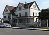
The John Steinbeck House is a historic house restaurant and house museum in Salinas, California. The house was the birthplace and family home of author John Steinbeck (1902–1968). It is noted for its Queen Anne architecture. The building was added to the National Register of Historic Places in 2000.
The Josiah Merritt Adobe, located at 386 Pacific St. in Monterey, California and also known as Merritt House, is a historic house that is listed on the National Register of Historic Places.
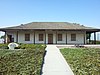
The Sheriff William Joseph Nesbitt House is a historic vernacular style house located at 66 Capitol Street, Salinas, California. The house was listed on the National Register of Historic Places on February 19, 1982.
References
↑ The latitude and longitude information provided in this table was derived originally from the National Register Information System, which has been found to be fairly accurate for about 99% of listings. Some locations in this table may have been corrected to current GPS standards.
↑ Numbers represent an alphabetical ordering by significant words. Various colorings, defined here, differentiate National Historic Landmarks and historic districts from other NRHP buildings, structures, sites or objects.
↑ The eight-digit number below each date is the number assigned to each location in the National Register Information System database, which can be viewed by clicking the number.
↑ Location derived from Map of the Lower Presidio Historic Park(PDF) (Map). City of Monterey. August 2005. Retrieved 2013-10-29. NRIS lists site as "address restricted".
↑ "El Castillo". Early History of the California Coast. National Park Service. Retrieved 2013-11-08.
↑ Speizer, Irwin (2004-05-02). "Jail that held Cesar Chavez at center of dispute; Supervisors see a crumbling relic that should be razed. Preservationists note its historical significance". Los Angeles Times.
This page is based on this Wikipedia article Text is available under the CC BY-SA 4.0 license; additional terms may apply. Images, videos and audio are available under their respective licenses.