Monterey is a city located in Monterey County on the southern edge of Monterey Bay on the U.S. state of California's Central Coast. Founded on June 3, 1770, it functioned as the capital of Alta California under both Spain (1804–1821) and Mexico (1822–1846). During this period, Monterey hosted California's first theater, public building, public library, publicly funded school, printing press, and newspaper. It was originally the only port of entry for all taxable goods in California. In 1846, during the Mexican–American War of 1846–1848, the United States Flag was raised over the Customs House. After Mexico ceded California to the U.S. at the end of the war, Monterey hosted California's first constitutional convention in 1849.

Monterey County, officially the County of Monterey, is a county located on the Pacific coast in the U.S. state of California. As of the 2020 census, its population was 439,035. The county's largest city and county seat is Salinas.

San Luis Obispo County, officially the County of San Luis Obispo, is a county on the Central Coast of California. As of the 2020 census, the population was 282,424. The county seat is San Luis Obispo.
Greenfield is a city in Monterey County, California, United States. Formerly Clarke Colony, it lies in the Salinas Valley, 33 miles (53 km) southeast of Salinas, at an elevation of 289 feet (88 m). As of the 2020 census, the population was 18,937, up from 16,330 in the 2010 census. Its most well-known public event is the annual Harvest Festival. Greenfield is a member of the Association of Monterey Bay Area Governments.
King City is a city in Monterey County, California, United States. It is located on the Salinas River 51 miles (82 km) southeast of Salinas, at an elevation of 335 feet (102 m). It lies along U.S. Route 101 in the Salinas Valley of California's Central Coast. King City is a member of the Association of Monterey Bay Area Governments. The population was 13,332 at the 2020 census, up from 12,874 in 2010.
Salinas is a city in the U.S. state of California and the county seat of Monterey County. With a population of 163,542 in the 2020 Census, Salinas is the most populous city in Monterey County. Salinas is an urban area located along the eastern limits of the Monterey Bay Area, lying just south of the San Francisco Bay Area and 10 miles (16 km) southeast of the mouth of the Salinas River. The city is located at the mouth of the Salinas Valley, about eight miles (13 km) from the Pacific Ocean, and it has a climate more influenced by the ocean than the interior.

Soledad is a city in Monterey County, California, United States. It is in the Salinas Valley, 21 miles (34 km) southeast of Salinas, the county seat. Soledad's population was 24,925 at the 2020 census, down from 25,738 in 2010. Soledad's origins started with Mission Nuestra Señora de la Soledad, founded by the Spanish in 1791, under the leadership of Fermín de Lasuén. Catalina Munrás began developing the town of Soledad on her Rancho San Vicente in the 1860s, which eventually incorporated as a city in 1921. Today, Soledad is a notable tourist destination, owing to the heavily restored mission, its proximity to Pinnacles National Park, and its numerous vineyards, as part of the Monterey wine region.

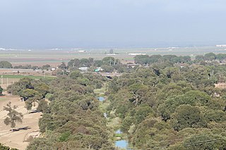
The Salinas Valley is one of the major valleys and most productive agricultural regions in California. It is located west of the San Joaquin Valley and south of San Francisco Bay and the Santa Clara Valley.

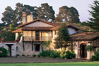
Carmel Valley is an unincorporated community in Monterey County, California, United States. The term "Carmel Valley" generally refers to the Carmel River watershed east of California State Route 1, and not specifically to the smaller Carmel Valley Village. For statistical purposes, the United States Census Bureau has defined Carmel Valley as a census county division (CCD), with an area covering approximately 189 square miles (490 km2). At the time of the 2020 census the CCD population was 6,189. In November 2009, a majority of residents voted against incorporation.

State Route 68 is a state highway in the U.S. state of California, located entirely in Monterey County. It runs from Asilomar State Beach in Pacific Grove to U.S. Route 101 in Salinas. The approximately 20-mile (32 km) long highway serves as a major route between the Monterey Peninsula and Salinas.
California's 18th congressional district is a congressional district located in the U.S. state of California. The district is currently represented by Democrat Zoe Lofgren. Since the 2022 election, the district is landlocked and includes all of San Benito County and parts of Santa Clara and Monterey counties, including Salinas, Hollister, Watsonville, Gilroy, Soledad, and downtown and eastern San Jose.
California's 17th congressional district is a congressional district in the U.S. state of California that is currently represented by Ro Khanna. It is located in the South Bay and East Bay regions of the San Francisco Bay Area.

Springtown is an unincorporated community in Monterey County, California, United States.
Old Hilltown, formerly Hill Town, is an unincorporated community in Monterey County, California. It is located on the north side of the Salinas River 3 miles (4.8 km) south-southwest of Salinas on California State Route 68, at an elevation of 46 feet, approximately two miles from Spreckels, California The name is from James Bryant Hill, one of the first settler in the area. The first European land exploration of Alta California, the Spanish Portolá expedition, camped on the Salinas River in this vicinity on September 30, 1769, having followed the river from the south for several days. From this camp, the scouts went out to survey the route ahead and saw Monterey Bay for the first time. Unsure whether the point they could see at the southern end of the bay was the "Point of Pines" described by Sebastian Vizcaino in 1602, Portola decided that the party should investigate.

Posts is an unincorporated community in the Big Sur region of Monterey County, California. It is located on the Big Sur Coast Highway, 4.8 miles (7.7 km) south of the Big Sur Village at an elevation of 945 feet.
Robles del Rio, sometimes spelled as Robles Del Rio, is an unincorporated community in Monterey County, California. It is located west of the Carmel River in Carmel Valley, at an elevation of 597 ft (182 m). For statistical purposes, the community is part of the Carmel Valley Village census-designated place.
San Benancio is an unincorporated community in Monterey County, California. It is located in the San Benancio Canyon.
The Monterey County Board of Supervisors is the central governing body for Monterey County, California. The Board is made up of five elected officials, each of whom represent a distinct geographical district within the County.
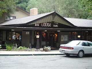
Big Sur Village is an unincorporated community in the Big Sur region, in Monterey County, California, United States. It is located along a 1-mile-long (1.6 km) stretch of Big Sur Coast Highway in the Big Sur Valley 24 miles (39 km) south of Carmel, California. The village contains the largest collection of shops and visitor services along the entire 71-mile (114 km) segment of California State Route 1 between Malpaso Creek near Carmel Highlands in the north and San Carpóforo Creek near San Simeon in the south. The population of the entire coastal region is about 1,463. The collection of small roadside businesses and homes is often confused with the larger region, also known as Big Sur. On March 6, 1915, United States Post Office granted the English-speaking residents' request to change the name of their post office from Arbolado to Big Sur. Caltrans also refers to the village as Big Sur.


