Carmel Point

Last updated

Carmel Point
Point Loeb
Charles King Van Riper Reamer's Point
Carmel Point at Scenic Road.jpg
Edward G. Kuster House, Carmel-by-the-Sea.jpg
Tor House, Carmel, California.jpg
Carmel Point Butterfly House.jpg
Carmel Point Rock Formation.jpg
Carmel Point river beach.jpg
From top, left to right: Scenic Road, Edward G. Kuster's House; Tor House; Butterfly House; Rock formation; Carmel River Beach
Map of Carmel Point.jpg
Location map Monterey Peninsula.png
Red pog.svg
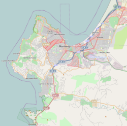
Carmel Point
Location in Monterey County
USA California location map.svg
Red pog.svg
Carmel Point
Carmel Point (California)
Coordinates: 36°32′37″N121°55′59″W / 36.54361°N 121.93306°W / 36.54361; -121.93306
CountryUnited States
State California
County Monterey County
Elevation
489 ft (149 m) ft (11 m)
Time zone UTC-8 (PST)
  Summer (DST) UTC-7 (PDT)
GNIS feature ID 254713

Carmel Point also known as the Point and formerly called Point Loeb and Reamer's Point, is an unincorporated community in Monterey County, California, United States. It is a cape located at the southern city limits of Carmel-by-the-Sea and offers views of Carmel Bay, the mouth of Carmel River, and Point Lobos. [1] Carmel Point was one of three major land developments adjacent to the Carmel city limits between 1922 and 1925. The other two were Hatton Fields, 233 acres (94 ha) between the eastern town limit and Highway 1, and Carmel Woods, 125 acres (51 ha) tract on the north side. [2]

Contents

History

The Carmel Point began with the Rumsen Ohlone Native American tribe, who inhabited the area in the 6th-century. [3] The Spanish explorers and missionaries arrived in the late 18th century and erected, within the Ohlone region, the Mission San Carlos Borroméo de Carmelo (founded in 1770). In 1834, the Mexican land grant ranchos took over the mission land and property. In 1848, Mexico ceded to California as a result of the Mexican–American War. [4]

Geography

The Carmel Point land is hilly to the east, but flat to the west, which is closest to the Carmel Bay. The highest point in the vicinity is 1,768.37 ft (539.00 m) high and is 18.7 ft (5.7 m) southeast of Carmel Point. There are about 23 people per square kilometer in Carmel Point's relatively small population. The nearest larger town is Seaside, California, which is 6.46 mi (10.40 km) northeast of Carmel Point. [5]

Climate

Climate data for Carmel Point
MonthJanFebMarAprMayJunJulAugSepOctNovDecYear
Mean daily maximum °F (°C)60.1
(15.6)
61.0
(16.1)
64.0
(17.8)
64.9
(18.3)
66.9
(19.4)
68.0
(20.0)
70.0
(21.1)
71.1
(21.7)
70.0
(21.1)
64.0
(17.8)
62.1
(16.7)
60.1
(15.6)
65.1
(18.4)
Mean daily minimum °F (°C)43.0
(6.1)
45.0
(7.2)
46.9
(8.3)
48.0
(8.9)
50.0
(10.0)
52.0
(11.1)
53.1
(11.7)
53.1
(11.7)
51.1
(10.6)
46.9
(8.3)
46.0
(7.8)
43.0
(6.1)
48.2
(9.0)
Average precipitation inches (mm)4.19
(106)
3.75
(95)
3.53
(90)
1.48
(38)
0.50
(13)
0.20
(5.1)
0.09
(2.3)
0.11
(2.8)
0.28
(7.1)
1.06
(27)
2.43
(62)
2.73
(69)
20.35
(517)
Source: [6]

See also

Related Research Articles

<span class="mw-page-title-main">Mission San Carlos Borromeo de Carmelo</span> 18th-century Spanish mission in California

Mission San Carlos Borromeo del Río Carmelo, or Misión de San Carlos Borromeo de Carmelo, first built in 1797, is one of the most authentically restored Catholic mission churches in California. Located at the mouth of Carmel Valley, California, it is on the National Register of Historic Places and is a National Historic Landmark.

<span class="mw-page-title-main">Mission San Francisco de Asís</span> 18th-century Spanish mission in California

The Mission San Francisco de Asís, also known as Mission Dolores, is a historic Catholic church complex in San Francisco, California. Operated by the Archdiocese of San Francisco, the complex was founded in the 18th century by Spanish Catholic missionaries. The mission contains two historic buildings:

<span class="mw-page-title-main">Mission San José (California)</span> 18th-century Spanish mission in California

Mission San José is a Spanish mission located in the present-day city of Fremont, California, United States. It was founded on June 11, 1797, by the Franciscan order and was the fourteenth Spanish mission established in California. The mission is the namesake of the Mission San José district of Fremont, which was an independent town subsumed into the city when it was incorporated in 1957. The Mission entered a long period of gradual decline after Mexican secularization act of 1833. After suffering decline, neglect and earthquakes most of the mission was in ruins. Restoration efforts in the intervening periods have reconstructed many of the original structures. The old mission church remains in use as a chapel of Saint Joseph Catholic Church, a parish of the Diocese of Oakland. The museum also features a visitor center, museum, and slide show telling the history of the mission.

<span class="mw-page-title-main">Carmel-by-the-Sea, California</span> City in California, United States

Carmel-by-the-Sea, commonly known simply as Carmel, is a city in Monterey County, California, located on the Central Coast of California. As of the 2020 census, the town had a total population of 3,220, down from 3,722 at the 2010 census. Situated on the Monterey Peninsula, Carmel is a popular tourist destination, known for its natural scenery and rich artistic history.

<span class="mw-page-title-main">Ohlone</span> Native American people of the Northern California coast

The Ohlone, formerly known as Costanoans, are a Native American people of the Northern California coast. When Spanish explorers and missionaries arrived in the late 18th century, the Ohlone inhabited the area along the coast from San Francisco Bay through Monterey Bay to the lower Salinas Valley. At that time they spoke a variety of related languages. The Ohlone languages make up a sub-family of the Utian language family. Older proposals place Utian within the Penutian language phylum, while newer proposals group it as Yok-Utian.

<span class="mw-page-title-main">Esselen</span> Indigenous American group in northern California

The Esselen are a Native American people belonging to a linguistic group in the hypothetical Hokan language family, who are Indigenous to the Santa Lucia Mountains of a region south of the Big Sur River in California. Prior to Spanish colonization, they lived seasonally on the coast and inland, surviving off the plentiful seafood during the summer and acorns and wildlife during the rest of the year.

<span class="mw-page-title-main">El Palo Alto</span> Historic coast redwood in Palo Alto, California

El Palo Alto is a coast redwood located on the banks of the San Francisquito Creek in Palo Alto, California, a city in the San Francisco Bay Area. The namesake of the city and a historical landmark, El Palo Alto is 1083–1084 years old and stands 110 feet (34 m) tall.

<span class="mw-page-title-main">Carmel Valley, California</span> Unincorporated community in California, United States

Carmel Valley is an unincorporated community in Monterey County, California, United States. The term "Carmel Valley" generally refers to the Carmel River watershed east of California State Route 1, and not specifically to the smaller Carmel Valley Village. For statistical purposes, the United States Census Bureau has defined Carmel Valley as a census county division (CCD), with an area covering approximately 189 square miles (490 km2). At the time of the 2020 census the CCD population was 6,189. In November 2009, a majority of residents voted against incorporation.

Ishxenta State Park is an 1,315-acre (532 ha) California state park in the northern region of Big Sur, California, United States. San Jose Creek on the ranch was the site of an Ohlone village for thousands of years. Europeans first visited the site when the Portolá expedition camped at the site for 10 days in the winter of 1769.

<span class="mw-page-title-main">Point Lobos</span> Cape in California, USA

Point Lobos and the Point Lobos State Natural Reserve is a state park in California. Adjoining Point Lobos is "one of the richest marine habitats in California." The ocean habitat is protected by two marine protected areas, the Point Lobos State Marine Reserve and Point Lobos State Marine Conservation Area. The sea near Point Lobos is considered one of the best locations for scuba diving on the Monterey Peninsula and along the California coast.

<span class="mw-page-title-main">Juan B. R. Cooper</span> American pioneer (1791–1872)

Juan Bautista Rogers Cooper was a 19th-century pioneer of California, who held British, Mexican, and finally American citizenship. Raised in Massachusetts in a maritime family, he came to the Mexican territory of Alta California as master of the ship Rover, and was a pioneer of Monterey, California, when it was the capital of the territory. He converted to Catholicism, became a Mexican citizen, married the daughter of the Mexican territorial governor, and acquired extensive land holdings in the area prior to the Mexican–American War.

<span class="mw-page-title-main">Rancho San José y Sur Chiquito</span>

Rancho San José y Sur Chiquito was a 8,876-acre (35.92 km2) Mexican land grant in present-day Big Sur, in Monterey County, California, given in 1835 to Teodoro Gonzalez and re-granted by Governor Juan Alvarado the same year to Marcelino Escobar. The grant, including Point Lobos, was located south of the Carmel River, extending inland along the coastal mountains, and south along the Pacific coast. It included San Jose Creek, Malpaso Creek, Soberanes Creek, Tres Pinos Creek, Garrapata Creek, and ended on the north side of Palo Colorado Canyon. A hand-drawn map created c. 1853 accompanying the grant indicated a road or trail was already present along the coast.

Rancho Cañada de la Segunda was a 4,367-acre (17.67 km2) Mexican land grant in present-day Monterey County, California given in 1839 by Governor José Castro to Lazaro Soto. The grant extended along the north bank of the Carmel River, from the Pacific coast and present day Carmel-by-the-Sea up into the Carmel Valley.

"Rancho Los Laureles" was a 718-acre (2.91 km2) Mexican land grant in present day Monterey County, California given in 1844 by Governor Manuel Micheltorena to José Agricio, an Ohlone Indian. The grant extended along the north side of the Carmel River and the Carmel Valley, was bounded to the east by the Boronda Rancho Los Laureles.

<span class="mw-page-title-main">Rumsen people</span> Indigenous people of California, US

The Rumsen are one of eight groups of the Ohlone, an indigenous people of California. Their historical territory included coastal and inland areas within what is now Monterey County, California, including the Monterey Peninsula.

<span class="mw-page-title-main">Rancho Las Camaritas</span> California land grant

Rancho Las Camaritas was an Alta California land grant, a square of 300 Mexican varas on each side; varas being one pace, in this case 2.75 feet to José de Jesús Noé on January 21, 1840, by Governor Juan Bautista Alvarado. Millions of acres of California land was given at no charge to men between 1784 and 1846 by the Spanish (1784–1810) or Mexican governments (1819–1846) mostly for military service to raise cattle on. About 300 of the 800 Land grants were sizable varying from a few thousand to 1.5 million acres – see List of ranchos of California for the larger grants. Following the Mexican–American War, the land grants were challenged with most of them falling into American hands. Only one land grant has remained undeveloped. The ownership of Las Camaritas was disputed in court by the U.S. government from 1856 until 1882 due to conflicting documentation presented by its American owner Ferdinand Vassault after a string of sales initiated by Jose Noe sometime between 1842 and 1846.

<span class="mw-page-title-main">Santa Lucia Preserve</span> Unincorporated community in California, United States

The Santa Lucia Preserve or The Preserve is a private, 20,000 acres (8,100 ha) gated development permitting 297 homesites. It is located in the foothills of the Santa Lucia Range between Palo Corona Regional Park and Carmel Valley, California. The Preserve consists of a 12,000 acres (4,900 ha) nature reserve, 8,000 acres (3,200 ha) of open land, and 2,000 acres (810 ha) for development. It contains most of the watershed of Las Garzas Creek, a tributary of the Carmel River.

<span class="mw-page-title-main">Carmel Woods</span> The unincorporated area north of Carmel-by-the-Sea, California

Carmel Woods is an unincorporated community in Monterey County, California, United States. It is located adjoining the northern city limits of Carmel-by-the-Sea and adjacent to Pebble Beach. Carmel Woods was laid out in 1922 by developer Samuel F. B. Morse (1885-1969). It included a 25-acre (0.10 km2) subdivision with 119 building lots. Carmel Woods was one of three major land developments adjacent to the Carmel city limits between 1922 and 1925. The other two were the Hatton Fields, a 233 acres (94 ha) between the eastern town limit and Highway 1, and the Walker Tract to the south, which was 216 acres (87 ha) of the Martin Ranch called The Point.

<span class="mw-page-title-main">Outlands in the Eighty Acres</span> Historic building in California

Outlands in the Eighty Acres, also known as Flanders Mansion is an 8,000-square-foot Tudor Revival house. It is significant as a work of architect Henry Higby Gutterson, and for its innovative construction with light grey interlocking Precast concrete blocks. It is one of the earliest architect designed residences in Carmel-by-the-Sea, and the only known example of work by Gutterson in the region. It is located within the Mission Trail Nature Preserve in Carmel-by-the-Sea, California. It was listed on the National Register of Historic Places on March 23, 1989.

References

  1. Geonameslink 254713 Carmel Point at Geonames.org (cc-by);post updated 2022-07-17
  2. "Outlands In The Eighty Acres". United States Department of Interior National Park Service. February 21, 1989. Retrieved October 18, 2022.
  3. Henson, Paul; Donald J. Usner (1996). The Natural History of Big Sur (illus. by Valerie A. Kells ed.). Berkeley: University of California Press. p. 265. ISBN   978-0-520-20510-9.
  4. "The U.S.-Mexican War (1846–1848). Treaty of Guadalupe Hidalgo". www.pbs.org. Archived from the original on February 13, 2010. Retrieved January 17, 2016.
  5. "Carmel Point". www.geonames.org. Retrieved July 18, 2022.
  6. "Carmel-by-the-Sea historic weather averages". Intellicast. Archived from the original on June 5, 2011. Retrieved February 12, 2010.