Greenfield is a city in Monterey County, California, United States. Formerly Clarke Colony, it lies in the Salinas Valley, 33 miles (53 km) southeast of Salinas, at an elevation of 289 feet (88 m). As of the 2020 census, the population was 18,937, up from 16,330 in the 2010 census. Its most well-known public event is the annual Harvest Festival. Greenfield is a member of the Association of Monterey Bay Area Governments.

The Esselen are a Native American people belonging to a linguistic group in the hypothetical Hokan language family, who are indigenous to the Santa Lucia Mountains of a region south of the Big Sur River in California. Prior to Spanish colonization, they lived seasonally on the coast and inland, surviving off the plentiful seafood during the summer and acorns and wildlife during the rest of the year.

The Arroyo Seco, meaning "dry stream" in Spanish, is a 24.9-mile-long (40.1 km) seasonal river, canyon, watershed, and cultural area in Los Angeles County, California. The area was explored by Gaspar de Portolà who named the stream Arroyo Seco as this canyon had the least water of any he had seen. During this exploration he met the Chief Hahamog-na (Hahamonga) of the Tongva Indians.
Esselen was the language of the Esselen Nation, which aboriginally occupied the mountainous Central Coast of California, immediately south of Monterey. It was probably a language isolate, though has been included as a part of the hypothetical Hokan proposal.

Hermon is a neighborhood in the northeast area of Los Angeles. It was established in 1903 and became part of Los Angeles in 1912.

J. Lohr Vineyards & Wines is a winemaking company headquartered in San Jose, California, with over 4,000 acres of estate vineyards in the Paso Robles AVA in San Luis Obispo County, Arroyo Seco and Santa Lucia Highlands AVAs in Monterey County, and the St. Helena AVA in Napa Valley, California. The family-owned and operated company was founded by Jerry Lohr in 1974. The company operates wineries in San Jose, Paso Robles, and Greenfield, California. In 2013, Steve Lohr was appointed CEO of the company. J. Lohr Vineyards & Wines’ product portfolio includes eight tiers of wine: J. Lohr Signature, J. Lohr Cuvée Series, J. Lohr Vineyard Series, J. Lohr Gesture, J. Lohr Pure Paso Proprietary Red Wine, J. Lohr Monterey Roots, J. Lohr Estates and ARIEL Vineyards. The portfolio also includes specialty brands Cypress Vineyards and Painter Bridge. J. Lohr ranks among the top 25 wine producers in the United States, with annual US sales exceeding 1.8 million cases.

Folsom site or Wild Horse Arroyo, designated by the Smithsonian trinomial 29CX1, is a major archaeological site about 8 miles (13 km) west of Folsom, New Mexico. It is the type site for the Folsom tradition, a Paleo-Indian cultural sequence dating to between 11000 BC and 10000 BC. The Folsom site was excavated in 1926 and found to have been a marsh-side kill site or camp where 32 bison had been killed using distinctive tools, known as Folsom points. This site is significant because it was the first time that artifacts indisputably made by humans were found directly associated with faunal remains from an extinct form of bison from the Late Pleistocene. The information culled from this site was the first of a set of discoveries that would allow archaeologists to revise their estimations for the time of arrival of Native Americans on the North American continent.

Gatecliff Rockshelter (26NY301) is a major archaeological site in the Great Basin area of the western United States that provides remarkable stratigraphy; it has been called the "deepest archaeological rock shelter in the Americas". Located in Mill Canyon of the Toquima Range in the Monitor Valley of central Nevada, Gatecliff Rockshelter has an elevation of 7,750 feet (2,360 m). David Hurst Thomas discovered Gatecliff Rockshelter in 1970 and began excavations in 1971. Full scale excavations occurred at Gatecliff Rockshelter for about seven field seasons in which nearly 33 feet (10 m) of sediments were exposed for a well-defined stratigraphic sequence. The well-preserved artifacts and undisturbed sediments at Gatecliff Rockshelter provides data and information have been applied to a range of research topics. Based on the analysis of the artifacts at Gatecliff Rockshelter, it can be determined that it was most likely a short-term field camp throughout prehistory. The latest evidence for human usage at Gatecliff occurs between ca. 5500 B.P. to 1250 B.P.
Leonard Rockshelter, designated 26PE14, is a prehistoric site in the U.S. state of Nevada that was discovered in 1936. It was declared a National Historic Landmark in 1961, qualifying because its well-preserved stratigraphy revealed a long continuum of sporadic cultural occupations from 6710 BC to AD 1400. The site was named after Zenas Leonard, a member of the Bonneville-Walker expedition which passed through the Humboldt Valley in 1833. It was added to the National Register of Historic Places in 1966.

Danger Cave is a North American archaeological site located in the Bonneville Basin of western Utah around the Great Salt Lakes region, that features artifacts of the Desert Culture from c. 9000 BC until c. 500 AD. Through carbon-14 dating, it has been determined that there is very little evidence of human life in the Danger Cave area c. 11,000 BP [9000 BC], but there is much evidence of human life by 9000 BP [7000 BC].
The Hoko River Archeological Site complex, located in Clallam County in the northwestern part of the U.S. state of Washington, is a 2,500-year-old fishing camp. Hydraulic excavation methods, which were first developed on the site, and artifacts found there have contributed to the understanding of the traditions and culture of the Makah people who have inhabited the northwest for 3,800 years. The site has also shed light on the evolution of food storage and the flora and fauna that existed in the area around 2500 B.P. Its name comes from the Hoko River.

Mummy Cave is a rock shelter and archeological site in Park County, Wyoming, United States, near the eastern entrance to Yellowstone National Park. The site is adjacent to the concurrent U.S. Routes 14/16/20, on the left bank of the North Fork of the Shoshone River at an altitude of 6,310 feet (1,920 m) in Shoshone National Forest.
Rancho Arroyo Seco was a 16,523-acre (66.87 km2) Mexican land grant in the Salinas Valley, in present-day Monterey County, California. It was given in 1840 by Governor Juan B. Alvarado to Joaquín de la Torre.

The LoDaisKa site is a prominent archaeological site in the U.S. state of Colorado, located within a rockshelter near Morrison. The rockshelter was first inhabited by people of the Archaic through the Middle Ceramic period, generally spanning 3000 BC to 1000 AD.

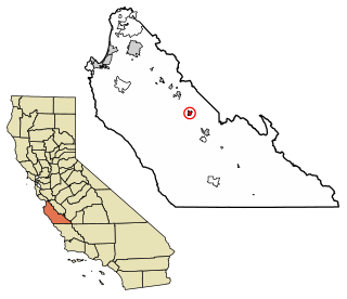
The Arroyo Seco is a major tributary of the Salinas River in central California. About 40 miles (64 km) long, it drains a rugged area of the Coast Ranges east of Big Sur before flowing through the agricultural Salinas Valley.

Franktown Cave is located 25 miles (40 km) south of Denver, Colorado on the north edge of the Palmer Divide. It is the largest rock shelter documented on the Palmer Divide, which contains artifacts from many prehistoric cultures. Prehistoric hunter-gatherers occupied Franktown Cave intermittently for 8,000 years beginning about 6400 BC The site held remarkable lithic and ceramic artifacts, but it is better known for its perishable artifacts, including animal hides, wood, fiber and corn. Material goods were produced for their comfort, task-simplification and religious celebration. There is evidence of the site being a campsite or dwelling as recently as AD 1725.
The Trinchera Cave Archeological District (5LA9555) is an archaeological site in Las Animas County, Colorado with artifacts primarily dating from 1000 BC to AD 1749, although there were some Archaic period artifacts found. The site was added to the National Register of Historic Places in 2001 and is located on State Trust Lands.
Archeological Site No. 1WI50 is an archaeological site in the Sipsey Wilderness of the William B. Bankhead National Forest in Winston County, Alabama. It was added to the National Register of Historic Places on December 14, 1985.
The River Road Wine Trail is a Salinas Valley wine-tasting route following River Road along the western banks of the Salinas River. It is not to be misidentified with the Great River Road that traverses along the banks of the Mississippi River through multiple states. The road also designates the eastern boundary of the Santa Lucia Highlands AVA and accesses many of the resident wineries contributing to local enotourism business. Due to its popularity, it is notably referenced in numerous books and magazines.

Kirk Creek Campground is an archaeological site dating to the Middle Period of the Big Sur coast in California. The campground is in Lucia, Monterey County, California, US. It was listed on the National Register of Historic Places on December 31, 1974.


