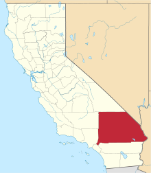
[3] Name on the Register [4] Image Date listed [5] Location City or town Description 1 6 Mile Corral Upload image April 26, 2021 (# 100004572 Morningstar Mine Rd. in Mojave National Preserve Coordinates missing Cima vicinity 2 8 Mile Corral Upload image April 26, 2021 (# 100004575 Near Kelso-Cima Rd. in Mojave National Preserve Coordinates missing Cima vicinity 3 10 Mile Corral Upload image April 26, 2021 (# 100004573 Morningstar Mine Rd. in Mojave National Preserve Coordinates missing Cima vicinity 4 A. K. Smiley Public Library A. K. Smiley Public Library December 12, 1976 (# 76000513 125 W. Vine St. 34°03′15″N 117°11′02″W / 34.054283°N 117.183892°W / 34.054283; -117.183892 (A. K. Smiley Public Library ) Redlands 5 Aiken's Wash National Register District Upload image May 24, 1982 (# 82002239 Mojave National Preserve [6] 35°14′22″N 115°44′55″W / 35.239429°N 115.748613°W / 35.239429; -115.748613 (Aiken's Wash National Register District ) Baker 6 Archeological Site CA SBR 3186 Upload image February 10, 1981 (# 81000170 Address Restricted Silver Lakes 7 Archeological Site CA-SBR-140 Upload image June 10, 2003 (# 03000119 Address Restricted Baker 8 Archeological Site No. D-4 Upload image October 25, 1985 (# 85003435 Address Restricted Needles 9 Archeological Site No. E-21 Upload image October 25, 1985 (# 85003430 Address Restricted Parker 10 Atchison, Topeka and Santa Fe Railway Passenger and Freight Depot Atchison, Topeka and Santa Fe Railway Passenger and Freight Depot February 2, 2001 (# 01000025 1170 W. 3rd St. 34°06′17″N 117°18′31″W / 34.104722°N 117.308611°W / 34.104722; -117.308611 (Atchison, Topeka and Santa Fe Railway Passenger and Freight Depot ) San Bernardino 11 Auerbacher Home Auerbacher Home August 1, 2012 (# 12000442 121 Sierra Vista Dr. 34°01′18″N 117°09′02″W / 34.021595°N 117.15063°W / 34.021595; -117.15063 (Auerbacher Home ) Redlands 12 Barnwell RSLCC Headquarters Upload image April 26, 2021 (# 100004577 Hart Mine Rd. near Ivanpah Rd. in Mojave National Preserve 35°17′31″N 115°14′10″W / 35.2919°N 115.2361°W / 35.2919; -115.2361 (Barnwell RSLCC Headquarters ) Nipton vicinity 13 Barnwell Corral and Wells Upload image April 26, 2021 (# 100004578 Near Barnwell on Hart Mine Rd. in Mojave National Preserve Coordinates missing Nipton vicinity 14 Barton Villa Barton Villa October 24, 1996 (# 96001176 11245 Nevada St. 34°02′58″N 117°12′58″W / 34.049444°N 117.216111°W / 34.049444; -117.216111 (Barton Villa ) Redlands 15 Beverly Ranch Beverly Ranch February 11, 2004 (# 04000018 923 W. Fern Ave. 34°02′39″N 117°11′16″W / 34.044167°N 117.187778°W / 34.044167; -117.187778 (Beverly Ranch ) Redlands 16 Bitter Spring Archaeological Site (4-SBr-2659) Upload image December 20, 1982 (# 82000981 Address Restricted Barstow 17 Black Canyon-Inscription Canyon-Black Mountain Rock Art District Black Canyon-Inscription Canyon-Black Mountain Rock Art District September 12, 2000 (# 00001046 Address Restricted Hinkley 18 Black Tank Corral Upload image June 2, 2021 (# 100004592 Near I-15 Coordinates missing Baker vicinity 19 Blackwater Well Upload image November 21, 2000 (# 00001326 Granite Wells Road [7] 35°21′29″N 117°20′54″W / 35.358021°N 117.348385°W / 35.358021; -117.348385 (Blackwater Well ) Red Mountain 20 Bono's Restaurant and Deli Bono's Restaurant and Deli January 10, 2008 (# 07001353 15395 Foothill Blvd. 34°06′23″N 117°28′09″W / 34.1063°N 117.46917°W / 34.1063; -117.46917 (Bono's Restaurant and Deli ) Fontana 21 CA SBr 1008A, CA SBr 1008B, CA SBr 1008C Upload image May 24, 1982 (# 82002241 Address Restricted Johannesburg 22 Calico Mountains Archeological District Upload image March 30, 1973 (# 73000430 Address Restricted Yermo 23 The California Theatre The California Theatre December 22, 2009 (# 09001116 562 W. 4th St. 34°06′25″N 117°17′44″W / 34.106814°N 117.29545°W / 34.106814; -117.29545 (The California Theatre ) San Bernardino 24 Carnegie Public Library Building Carnegie Public Library Building June 23, 1988 (# 88000894 380 N. La Cadena Dr. 34°04′08″N 117°19′22″W / 34.068889°N 117.322778°W / 34.068889; -117.322778 (Carnegie Public Library Building ) Colton Now houses Colton Area Museum 25 City Transfer and Storage Company Warehouse Upload image October 23, 2023 (# 100009474 440 Oriental Ave. 34°03′31″N 117°11′17″W / 34.0585°N 117.1880°W / 34.0585; -117.1880 (City Transfer and Storage Company Warehouse ) Redlands 26 Cottonwood Corral Upload image April 26, 2021 (# 100004571 Near Morningstar Mine Rd. in Mojave National Preserve Coordinates missing Cima vicinity 27 Counsel Rocks Upload image August 23, 2021 (# 100006816 Address Restricted Essex vicinity (Mojave National Preserve ) 28 Cow Camp Cow Camp October 29, 1975 (# 75000228 Southwest of Twentynine Palms in Joshua Tree National Park 34°02′15″N 116°10′02″W / 34.0375°N 116.167222°W / 34.0375; -116.167222 (Cow Camp ) Twentynine Palms 29 Crowder Canyon Archeological District Upload image June 16, 1976 (# 76000514 Address Restricted San Bernardino 30 Cucamonga Service Station Cucamonga Service Station July 23, 2018 (# 100002675 9670 Foothill Blvd. 34°06′24″N 117°35′39″W / 34.1067°N 117.5941°W / 34.1067; -117.5941 (Cucamonga Service Station ) Rancho Cucamonga 31 Cut Tank Corral Upload image April 26, 2021 (# 100004570 Near Morningstar Mine Rd. in Mojave National Preserve Coordinates missing Cima vicinity 32 Deer Spring Corral Upload image April 29, 2021 (# 100004590 Near Cima Rd. in Mojave National Preserve Coordinates missing Cima vicinity 33 Dove Corral Upload image April 26, 2021 (# 100004579 Remote location in New York Mountains in Mojave National Preserve Coordinates missing Nipton vicinity 34 Robert J. Dunn House Robert J. Dunn House July 24, 2017 (# 100001336 1621 Garden St. 34°01′48″N 117°09′32″W / 34.030027°N 117.158953°W / 34.030027; -117.158953 (Robert J. Dunn House ) Redlands 35 Eagle Well Petroglyph Site Upload image July 27, 2015 (# 15000470 Address Restricted Barstow 36 El Garces El Garces May 17, 2002 (# 02000537 950 Front St. 34°50′27″N 114°36′20″W / 34.840833°N 114.605556°W / 34.840833; -114.605556 (El Garces ) Needles 37 Dr. Orville S. Ensign House Dr. Orville S. Ensign House March 20, 2012 (# 12000126 304 S. Laurel Ave. 34°03′39″N 117°39′09″W / 34.060908°N 117.652634°W / 34.060908; -117.652634 (Dr. Orville S. Ensign House ) Ontario 38 Euclid Avenue Euclid Avenue August 10, 2005 (# 05000843 From 24th St. in Upland to Philadelphia St. in Ontario 34°09′01″N 117°39′02″W / 34.150278°N 117.650556°W / 34.150278; -117.650556 (Euclid Avenue ) Upland and Ontario 39 First Christian Church of Rialto First Christian Church of Rialto February 20, 2003 (# 03000037 201 N. Riverside Ave. 34°06′10″N 117°22′09″W / 34.102778°N 117.369167°W / 34.102778; -117.369167 (First Christian Church of Rialto ) Rialto 40 Fontana Farms Company Ranch House, Camp No. 1 Fontana Farms Company Ranch House, Camp No. 1 November 1, 1982 (# 82000982 8863 Pepper St. 34°05′34″N 117°26′28″W / 34.092778°N 117.441111°W / 34.092778; -117.441111 (Fontana Farms Company Ranch House, Camp No. 1 ) Fontana 41 Fontana Pit and Groove Petroglyph Site Upload image April 17, 1980 (# 80000838 Address Restricted Fontana 42 Fossil Canyon Petroglyph Site Fossil Canyon Petroglyph Site March 3, 2003 (# 02000980 Rainbow Basin 35°01′46″N 117°02′12″W / 35.0294°N 117.0367°W / 35.0294; -117.0367 (Fossil Canyon Petroglyph Site ) Barstow 43 Foxtrot Petroglyph Site Foxtrot Petroglyph Site February 23, 1995 (# 95000044 Address Restricted, Marine Corps Air Ground Combat Center Twentynine Palms Twentynine Palms Area of rock art panels more than 2 kilometres (1.2 mi) long. 44 Frankish Building Frankish Building August 11, 1980 (# 80000839 200 S. Euclid Ave. 34°03′45″N 117°39′01″W / 34.0625°N 117.650278°W / 34.0625; -117.650278 (Frankish Building ) Ontario 45 Goffs Schoolhouse Goffs Schoolhouse October 11, 2001 (# 01001102 37198 Lanfair Rd. 34°55′12″N 115°03′18″W / 34.92°N 115.055°W / 34.92; -115.055 (Goffs Schoolhouse ) Goffs 46 Government Holes Upload image April 26, 2021 (# 100004586 Cedar Canyon Rd. near Rock Spring in Mojave National Preserve Coordinates missing Cima vicinity 47 Guapiabit– Serrano Homeland Archaeological District Upload image October 26, 2020 (# 100001258 Address Restricted Hesperia vicinity 48 Hackberry Corral Upload image April 26, 2021 (# 100004583 Near Lanfair Rd. in Mojave National Preserve Coordinates missing Goffs vicinity 49 Harvey House Railroad Depot Harvey House Railroad Depot April 3, 1975 (# 75000458 Santa Fe Depot 34°54′17″N 117°01′26″W / 34.904722°N 117.023889°W / 34.904722; -117.023889 (Harvey House Railroad Depot ) Barstow 50 Highland Historic District Highland Historic District April 5, 2001 (# 01000333 Roughly bounded by Cole and Nona Ave., Pacific and Church Sts. 34°07′40″N 117°12′29″W / 34.127778°N 117.208056°W / 34.127778; -117.208056 (Highland Historic District ) Highland 51 Hofer Ranch Hofer Ranch July 8, 1993 (# 93000596 11248 S. Turner Ave. 34°02′56″N 117°35′05″W / 34.048889°N 117.584722°W / 34.048889; -117.584722 (Hofer Ranch ) Ontario 52 Integratron Integratron April 23, 2018 (# 100002317 2477 Belfield Blvd. 34°17′40″N 116°24′13″W / 34.294330°N 116.403749°W / 34.294330; -116.403749 (Integratron ) Landers 53 Judson and Brown Ditch Judson and Brown Ditch September 29, 2015 (# 15000646 Crosses San Bernardino FCD Rd. 34°06′14″N 117°06′14″W / 34.103915°N 117.103805°W / 34.103915; -117.103805 (Judson and Brown Ditch ) Redlands Linear noncontiguous feature that extends from Highland to Redlands 54 Kelso Depot, Restaurant and Employees Hotel Kelso Depot, Restaurant and Employees Hotel August 2, 2001 (# 01000760 Kelbaker Rd., junction of Kelbaker and Cima Rds. at Union Pacific Railroad crossing 35°00′44″N 115°39′09″W / 35.012222°N 115.6525°W / 35.012222; -115.6525 (Kelso Depot, Restaurant and Employees Hotel ) Kelso Boundary increase approved January 31, 2019 55 Keys Desert Queen Ranch Keys Desert Queen Ranch October 30, 1975 (# 75000174 Southwest of Twentynine Palms in Joshua Tree National Park 34°02′36″N 116°09′59″W / 34.043333°N 116.166389°W / 34.043333; -116.166389 (Keys Desert Queen Ranch ) Twentynine Palms 56 Kimberly Crest Kimberly Crest March 28, 1996 (# 96000328 1325 Prospect Dr. 34°02′16″N 117°10′21″W / 34.037778°N 117.1725°W / 34.037778; -117.1725 (Kimberly Crest ) Redlands 57 Lanfair Corral Upload image April 26, 2021 (# 100004584 Near Lanfair Rd. in Mojave National Preserve Coordinates missing Goffs vicinity 58 Sam and Alfreda Maloof Compound Sam and Alfreda Maloof Compound November 9, 2010 (# 03000471 5131 Carnelian St. 34°09′40″N 117°36′56″W / 34.161111°N 117.615556°W / 34.161111; -117.615556 (Sam and Alfreda Maloof Compound ) Alta Loma 59 Mary's Cave Upload image August 23, 2021 (# 100006817 Address Restricted Essex vicinity (Mojave National Preserve ) 60 Marl Springs Corral Upload image April 26, 2021 (# 100004576 Near Old Government Rd. in Mojave National Preserve Coordinates missing Kelso vicinity 61 Mescal Mining District Upload image June 5, 2023 (# 100004815 9.1 miles (14.6 km) southeast of the intersection of Cima Rd. and I 15 35°25′45″N 115°33′05″W / 35.4292°N 115.5513°W / 35.4292; -115.5513 (Mescal Mining District ) Cima vicinity 62 Mill Creek Zanja Mill Creek Zanja May 12, 1977 (# 77000329 Sylvan Blvd. E to Mill Creek Rd. 34°03′44″N 117°07′23″W / 34.062222°N 117.123056°W / 34.062222; -117.123056 (Mill Creek Zanja ) Redlands 63 Mojave Road Mojave Road September 27, 2021 (# 100007003 Mojave Rd., Mojave National Preserve 34°00′53″N 117°41′23″W / 34.014722°N 117.689722°W / 34.014722; -117.689722 (Mojave Road ) Baker vicinity 64 Moyse Building Moyse Building February 28, 1979 (# 79000522 13150 7th St. 34°00′53″N 117°41′23″W / 34.014722°N 117.689722°W / 34.014722; -117.689722 (Moyse Building ) Chino 65 Murphy Well Corral Upload image April 26, 2021 (# 100004594 Nipton Rd. in Mojave National Preserve Coordinates missing Nipton vicinity 66 Natural Corral Upload image April 29, 2021 (# 100004591 Near I-15 in Mojave National Preserve Coordinates missing Baker vicinity 67 New City of Mentalphysics Historic District New City of Mentalphysics Historic District January 17, 2023 (# 100008539 59700 Twentyninepalms Hwy. 34°08′07″N 116°21′35″W / 34.1353°N 116.3596°W / 34.1353; -116.3596 (New City of Mentalphysics Historic District ) Joshua Tree 68 Newberry Cave Site Upload image November 21, 2000 (# 00001325 Address Restricted Newberry Springs 69 OX Ranch Headquarters Upload image April 26, 2021 (# 100004580 Lanfair Rd. in Mojave National Preserve Coordinates missing Goffs vicinity 70 Old San Antonio Hospital Old San Antonio Hospital January 2, 1980 (# 80000840 792 W. Arrow Hwy. 34°05′58″N 117°39′34″W / 34.099444°N 117.659444°W / 34.099444; -117.659444 (Old San Antonio Hospital ) Upland 71 Ontario and San Antonio Heights Waiting Station Ontario and San Antonio Heights Waiting Station September 25, 2012 (# 12000813 1251 W. 24th St. 34°09′05″N 117°40′20″W / 34.151511°N 117.672223°W / 34.151511; -117.672223 (Ontario and San Antonio Heights Waiting Station ) Upland A passenger station for the Ontario and San Antonio Heights Railroad streetcar line 72 Ontario Baseball Park Upload image September 20, 2021 (# 100006913 SE of North Grove Ave. and East 4th St. intersection (NE corner John Galvin Park) 34°04′36″N 117°37′41″W / 34.0768°N 117.62805°W / 34.0768; -117.62805 (Ontario Baseball Park ) Ontario 73 Ontario State Bank Block Ontario State Bank Block January 8, 1982 (# 82002242 300 S. Euclid Ave. 34°03′42″N 117°39′02″W / 34.061667°N 117.650556°W / 34.061667; -117.650556 (Ontario State Bank Block ) Ontario Demolished to make way for lowering Euclid Avenue below the railroad tracks. 74 Pacific Electric Etiwanda Depot Pacific Electric Etiwanda Depot March 21, 2011 (# 11000119 7092 Etiwanda Ave. 34°07′30″N 117°31′23″W / 34.125°N 117.523056°W / 34.125; -117.523056 (Pacific Electric Etiwanda Depot ) Rancho Cucamonga 75 Payne Corral Upload image April 26, 2021 (# 100004585 Off Cedar Canyon Rd. near Rock Spring in Mojave National Preserve Coordinates missing Cima vicinity 76 Pioneer Deep Space Station Pioneer Deep Space Station October 3, 1985 (# 85002813 Goldstone Deep Space Communications Complex 35°23′21″N 116°51′22″W / 35.389167°N 116.856111°W / 35.389167; -116.856111 (Pioneer Deep Space Station ) Fort Irwin Also known as DSS 11, the first radio telescope at the Goldstone Deep Space Communications Complex . 77 Pioneertown Mane Street Historic District Pioneertown Mane Street Historic District May 26, 2020 (# 100005220 Mane St. 34°09′25″N 116°29′49″W / 34.1570°N 116.4969°W / 34.1570; -116.4969 (Pioneertown Mane Street Historic District ) Pioneertown 78 Pipeline Corral Upload image April 26, 2021 (# 100004581 Near Lanfair Rd. in Mojave National Preserve Coordinates missing Goffs vicinity 79 Piute Dry Corral Upload image April 26, 2021 (# 100004582 10 miles (16 km) E. of Lanfair Rd. in Mojave National Preserve Coordinates missing Goffs vicinity 80 Piute Pass Archeological District Upload image August 14, 1973 (# 73000429 Address Restricted Needles 81 Thomas Place Corral Upload image April 26, 2021 (# 100004574 Near Cedar Canyon Rd. in Mojave National Preserve Coordinates missing Cima vicinity 82 Providence Townsite Upload image August 16, 2016 (# 16000522 10 miles (16 km) off Essex Rd. 34°58′54″N 115°30′26″W / 34.981766°N 115.507272°W / 34.981766; -115.507272 (Providence Townsite ) Essex 83 John Rains House John Rains House April 24, 1973 (# 73000428 7869 Vineyard Ave. 34°06′40″N 117°36′36″W / 34.111111°N 117.61°W / 34.111111; -117.61 (John Rains House ) Rancho Cucamonga Entrance to the museum is now off Hemlock Street the address is 8810 Hemlock St. 84 Redlands Central Railway Company Car Barn Redlands Central Railway Company Car Barn January 3, 1991 (# 90002119 746 E. Citrus Ave. 34°03′24″N 117°10′29″W / 34.056667°N 117.174722°W / 34.056667; -117.174722 (Redlands Central Railway Company Car Barn ) Redlands 85 Redlands Santa Fe Depot District Redlands Santa Fe Depot District October 29, 1991 (# 91001535 Roughly bounded by Stuart Ave., N. 5th St., Redlands Blvd., Eureka St. and the SFRR tracks 34°03′31″N 117°10′57″W / 34.058611°N 117.1825°W / 34.058611; -117.1825 (Redlands Santa Fe Depot District ) Redlands 86 Rock Tank Corral Upload image April 29, 2021 (# 100004593 Near I-15 in Mojave National Preserve Coordinates missing Baker vicinity 87 Rodman Mountains Petroglyphs Archeological District Upload image May 10, 1982 (# 82002240 Address Restricted Barstow 88 Russian Village District Russian Village District December 28, 1978 (# 78000680 290-370 S. Mills Ave. and 480 Cucamonga Ave. 34°05′29″N 117°42′24″W / 34.091389°N 117.706667°W / 34.091389; -117.706667 (Russian Village District ) Montclair 89 San Bernardino County Court House San Bernardino County Court House January 12, 1998 (# 97001632 351 N. Arrowhead Ave. 34°06′20″N 117°17′26″W / 34.105556°N 117.290556°W / 34.105556; -117.290556 (San Bernardino County Court House ) San Bernardino 90 Shady Point Shady Point October 5, 2009 (# 09000804 778 Shelter Cove Dr. 34°15′46″N 117°11′00″W / 34.262647°N 117.183225°W / 34.262647; -117.183225 (Shady Point ) Lake Arrowhead 91 Smiley Park Historic District Smiley Park Historic District December 29, 1994 (# 94001487 Roughly bounded by Brookside Ave., Cajon St., Cypress Ave. and Buena Vista St. 34°03′03″N 117°10′56″W / 34.050833°N 117.182222°W / 34.050833; -117.182222 (Smiley Park Historic District ) Redlands 92 Soda Springs Historic District Soda Springs Historic District November 8, 2022 (# 100004814 4.8 miles (7.7 km) south of I 15 , on Zzyzx Rd. 35°08′36″N 116°06′22″W / 35.1434°N 116.1061°W / 35.1434; -116.1061 (Soda Springs Historic District ) Baker vicinity 93 Squaw Spring Archeological District Upload image July 28, 1981 (# 81000169 Address Restricted Red Mountain 94 Topock Maze Archeological Site Upload image October 5, 1978 (# 78000745 Address Restricted Needles 95 Upland Public Library Upland Public Library December 10, 1990 (# 90001817 123 E. D St. 34°05′55″N 117°38′55″W / 34.098611°N 117.648611°W / 34.098611; -117.648611 (Upland Public Library ) Upland 96 US Post Office-Downtown Station US Post Office-Downtown Station January 11, 1985 (# 85000136 390 W. 5th St. 34°06′31″N 117°17′26″W / 34.108611°N 117.290556°W / 34.108611; -117.290556 (US Post Office-Downtown Station ) San Bernardino 97 US Post Office-Redlands Main US Post Office-Redlands Main January 11, 1985 (# 85000135 201 Brookside Ave. 34°03′18″N 117°11′05″W / 34.055°N 117.184722°W / 34.055; -117.184722 (US Post Office-Redlands Main ) Redlands 98 Vulcan Mine Historic District Upload image July 15, 2019 (# 100004180 5.28 miles (8.50 km) E. of Kelbaker Rd., on Vulcan Mine Rd. 34°55′18″N 115°34′15″W / 34.9216°N 115.5708°W / 34.9216; -115.5708 (Vulcan Mine Historic District ) Kelso vicinity 99 Wall Street Mill Wall Street Mill November 12, 1975 (# 75000176 South of Twentynine Palms in Joshua Tree National Park 34°02′10″N 116°07′59″W / 34.036111°N 116.133056°W / 34.036111; -116.133056 (Wall Street Mill ) Twentynine Palms 100 Henry Washington Survey Marker Henry Washington Survey Marker May 12, 1975 (# 75000459 South of Big Bear City in San Bernardino National Forest 34°07′13″N 116°55′46″W / 34.120278°N 116.929444°W / 34.120278; -116.929444 (Henry Washington Survey Marker ) Big Bear City 101 Watson Buttes Upload image 2024-04-022(# 100010224 Address Restricted Essex vicinity 102 Watson Well Corral Upload image April 26, 2021 (# 100004587 South of Cedar Canyon Rd. in Mojave National Preserve Coordinates missing Cima vicinity 103 Wigwam Village No. 7 Wigwam Village No. 7 January 3, 2012 (# 11000957 2728 Foothill Rd. 34°06′26″N 117°21′00″W / 34.107258°N 117.35°W / 34.107258; -117.35 (Wigwam Village No. 7 ) San Bernardino 104 Yorba-Slaughter Adobe Yorba-Slaughter Adobe July 7, 1975 (# 75000460 5.5 miles (8.9 km) south of Chino at 17127 Pomona Rincon Rd. 33°56′26″N 117°39′52″W / 33.940556°N 117.664444°W / 33.940556; -117.664444 (Yorba-Slaughter Adobe ) Chino