Altamont is an unincorporated community in Alameda County, California. It is located 7.5 miles (12 km) northeast of Livermore, at an elevation of 741 feet (226 m) in the Altamont Pass. It was in 1969 the site of the Altamont Free Concert at the Altamont Speedway. Originally called The Summit, the name was changed to Altamont when the Central Pacific Railroad arrived in 1869.

Caliente is an unincorporated community in Kern County, California. It is located 22 miles (35 km) east-southeast of Bakersfield, at an elevation of 1,312 feet (400 m).

Famoso is an unincorporated community in Kern County, California. It is located on Poso Creek 5.5 miles (8.9 km) south-southeast of McFarland, at an elevation of 427 feet (130 m). Famoso is located at the junction of State Route 99 and the eastern terminus of State Route 46. The town is famous for its nut groves and especially the race track - Auto Club Famoso Raceway.
Tormey, formerly known as El Cierbo from the (Spanish word 'Ciervo' for 'Elk', is an unincorporated community in Contra Costa County, California, United States. It is located between Rodeo and Crockett on the edge of the ConocoPhillips oil refinery in Rodeo. It is 6.5 miles west-northwest of Martinez, at an elevation of 20 feet. The community is home to less than a dozen homes and the former offices of the John Swett Unified School District.
Alton is an unincorporated community in Humboldt County, California. It is located 3.5 miles (5.6 km) south-southeast of Fortuna, at an elevation of 62 feet. Alton is located along U.S. Route 101 and State Route 36. The ZIP Code is 95540. The community is inside area code 707.
Cooper is an unincorporated community in Monterey County, California, United States. It is located on the Southern Pacific Railroad and California State Route 183 4.5 miles (7.2 km) northwest of Salinas and southeast of Castroville. The elevation is 23 feet.
East Biggs is a small unincorporated community in Butte County, California. It lies at an elevation of 121 feet.
Dresser is an unincorporated community in Alameda County, California. Its ZIP code is 94536 and its area codes are 510 and 341.
The Mesquite Hills are a low mountain range in the Mojave Desert, in San Bernardino County, southern California.

Nichols is an unincorporated community in Contra Costa County, California, United States. It is on the Atchison, Topeka and Santa Fe Railroad 5.5 miles (9 km) west of Pittsburg, at an elevation of 62 feet. The place is named for William H. Nichols, president of the General Chemical Company of New York, which built in 1909 a plant here to produce fertilizer and a number of other chemicals for industrial use. In 1921, General Chemical became a division of Nichols's Allied Chemical, later Allied Corporation.

The AAA World Cruiserweight Championship is a professional wrestling championship contested for in the Mexican lucha libre promotion Lucha Libre AAA Worldwide (AAA). The championship cannot be competed for by anyone who is over the Cruiserweight division weight limit of 105 kg (231 lb). Traditionally this division is labelled as the "Junior Heavyweight" division in Mexico while "Cruiserweight" is a term more used in the United States or Canada.
Lerdo is an unincorporated community in Kern County, California. It is located on the Southern Pacific Railroad 12 miles (19 km) northwest of Bakersfield, at an elevation of 417 feet.
Saco is an unincorporated community in Kern County, California. It is located on the Southern Pacific Railroad 7 miles (11 km) northwest of Bakersfield, at an elevation of 453 feet (138 m).
Bronco is a former settlement in Nevada County, California, 9.5 mi (15.3 km) from Truckee by the Southern Pacific Railroad. Its elevation is 5,348 ft (1,630 m) above sea level.
Gabilan was a former settlement in Monterey County, California. It was located on the Southern Pacific Railroad 4 miles (6.4 km) northwest of Gonzales, at an elevation of 112 feet, and was situated in the foothills of the Gabilan Range. In Spanish, gavilán means "sparrow hawk". Hawks, especially the red-tailed hawk, are common in the area.
Metz is an unincorporated community in the Salinas Valley, in Monterey County, California. It is located on the Southern Pacific Railroad and County Route G15, 3 miles (4.8 km) northeast of Greenfield, at an elevation of 236 feet.
Nacimiento is an unincorporated community in Monterey County, California. It is located on the Southern Pacific Railroad 5 miles (8 km) southeast of Bradley, at an elevation of 636 feet.

Coyote Creek is a stream in the Richardson Bay watershed, draining Tamalpais-Homestead Valley, California eastward into Richardson Bay, Marin County, California, United States. The stream originates on Coyote Ridge and flows 2.5 miles (4.0 km) to the bay at the south end of Bothin Marsh.
Magra is an unincorporated community in Placer County, California. Magra is located on the former Southern Pacific Railroad, 4.5 miles (7.2 km) northeast of Colfax. It lies at an elevation of 2887 feet.
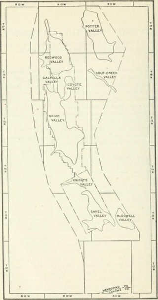
The Ukiah area is an area of 303 square miles (78,000 ha) in southeastern Mendocino County, California that encompasses the arable valleys of the Russian River drainage system and the adjacent parts of the Mendocino Range Mountains of the Pacific Coast Range.

