Crafton, California

Last updated

Crafton, California
CraftonSanGorgonio.jpg
Orange trees at the intersection of Crafton and Citrus Avenues.
San Gorgonio Mountain in the distance
Relief map of California.png
Red pog.svg
Crafton, California
Location within the state of California
Usa edcp relief location map.png
Red pog.svg
Crafton, California
Crafton, California (the United States)
Coordinates: 34°3′19″N117°7′17″W / 34.05528°N 117.12139°W / 34.05528; -117.12139
Country United States
State California
County San Bernardino
Elevation
[1]
1,755 ft (535 m)
Time zone UTC-8 (PST)
  Summer (DST) UTC-7 (PDT)
ZIP codes
92374
Area code 909
GNIS feature ID252875 [1]

Crafton is an unincorporated community in San Bernardino County, California, United States, located east of Redlands, south of Mentone and west of Yucaipa, California.

Contents

History

Crafton was one of the first communities established in the San Bernardino Valley area. Lewis Cram and his brothers had been in the business of making chairs at San Bernardino de Sena Estancia (also known as Old San Bernardino), but around 1857, they decided to move upstream along the community aqueduct (called the zanja, Spanish for ditch) in order to gain more milling power from the water flow. Other settlers began to settle the area, planting barley, wheat, grapes, apples and peaches. George H. Crafts, Sr. bought land, known as the Altoona Ranch, in the area then called Eastberne in 1858 for his brother Myron, who arrived in 1861 to find George had already established a bounty of crops. In 1870, Myron H. Crafts planted an acre and a half of navel oranges, and the success of his crop soon convinced others in the area to plant larger plots. [2] The Crafts ranch became popular as a resort; a person who regained his or her health there called it Crafton, and the area has been known by that name since. [3]

Soon, Crafton began to rival Old San Bernardino in agricultural production. Myron H. Crafts, said to be intelligent and energetic, had begun to divert too much water from the zanja which carried water from Mill Creek. In court in 1864, Dr. Benjamin Barton of Old San Bernardino claimed exclusive right to all water in Mill Creek, with Crafts to have none. The court took a compromise stance that allowed Crafts to have any water he could divert daily between three o'clock in the afternoon and nine at night. [4]

In 1867, W. W. McCoy filed a claim which would allow him to divert excess seasonal water from Mill Creek to his land in Crafton. His claim was denied at first but allowed later. [4]

In 1870, another water suit was filed, this time by Crafts, for the purpose of once more defining his right to water in the zanja. The court decision established that he had the right to four hours of water per day. In 1871, the court decided further that Crafts must divide the stream of water into two flows, one for others and a smaller one for himself, an order which Crafts did not carry out. Crafts bought his neighbor's farms to the east through which the zanja ran, and reasoned that, since he thought of the ditch as a natural stream, which it resembled in places, that he should have half of its water. Other farmers in the area disagreed and brought suit. This case was taken to the California Supreme Court, where Crafts lost. [4]

The first Protestant religious service in San Bernardino Valley was held in the Crafts home in 1873. [2]

Having accumulated 1,800 acres (7.3 km2) of land by this time, [2] Myron H. Crafts established the Crafton Land and Water Company in 1882, and constructed a reservoir above the subdivision of Crafton: the Crafton Reservoir. The Crafton School District was organized in 1882, and a bond passed in 1887 to erect a schoolhouse first used in 1888. A post office was established in Crafton in 1885, with M.H. Crafts as postmaster. [2] In 1886, the Crafton Water Company was formed by other area residents who bought the reservoir from Crafts and expanded it. Initially, they owned 14% of zanja flow but by 1949 had increased ownership to 53%. [4]

In the 1870s and 1880s, a number of Native Americans of the Cahuilla tribe remained living in Crafton, working at agricultural tasks and tending sheep and stock that were owned by white settlers. Myron Crafts constructed a store for trading with the natives in the early 1880s. The building's first floor was the general store; its second floor was used as a Sunday School. [2]

Geography

Crafton lies on a sloped alluvial plain of the San Bernardino basin. The elevation increases toward the southeast. [5] The area is fairly dry and requires irrigation to supply the navel orange groves. The supply of mountain water via Zanja Aqueduct is plentiful.

South and east of Crafton rise the Crafton Hills, a low, rolling set of hills created by about ten active [6] [7] normal dip-slip faults collectively called the Crafton Hills fault zone [8] or the Crafton Hills Horst-and-Graben Complex [9] which stretches between the San Jacinto fault and the San Andreas Fault. The highest point, Zanja Peak, tops out at 3,297 feet (1,005 m), approximately 1,600 feet (490 m) above Crafton. [10] Crafton Hills is home to Crafton Hills College and includes recreational trails [11] and the Crafton Reservoir, which supplies Crafton and Redlands with water.

Crafton holds the record for the highest temperature recorded in the United States in November, when on November 12, 1906, the temperature reached 105°F (40.6°C). [12]

Community

The neighboring city of Redlands considers Mentone and Crafton as being within its sphere of influence; Crafton has no community plan of its own, though it has striven to maintain a rural feel with 50% of its homes hidden amid citrus groves. [13] The maintaining of 5-acre (20,000 m2) lots per residence was seen as a Crafton goal, as was the avoidance of its annexation to Redlands. Redlands noted in 2006 that if Crafton continues with their pattern of "grove estate" homes, the whole area can be annexed once the pattern is established, and that developers will go along with this. [13]

The sloping land of Crafton serves as a watershed for Redlands, so the nearby city continues to be concerned with Crafton's water issues. Crafton has been observed by Redlands as having most of its residences on city water but not using city sewer services. Most homes use a septic tank system. [13]

Crafton's historic citrus groves are inexpensive to sustain, making the area possibly the last agricultural community in the San Bernardino Valley area. A concern voiced in 2006 was the maintenance of the necessary agricultural infrastructure. Another concern is that increasing traffic through the area will have a deleterious effect on farming efforts. [13]

Government

Federal

Crafton is located in California's 41st congressional district, which has a Cook PVI of D +9 and is represented by Democrat Mark Takano.

State

In the state legislature Crafton is located in the 23rd Senate District, represented by Republican Bill Emmerson, and in the 40th and 42nd Assembly Districts, represented by Republicans Mike Morrell and Brian Nestande respectively.

Local

Crafton is an unincorporated community in San Bernardino County.

Community services

Crafton is patrolled by the San Bernardino Sheriff's department. Yucaipa Animal Control includes Crafton in their duties.

Related Research Articles

<span class="mw-page-title-main">Southern California</span> American geographic and cultural region

Southern California is a geographic and cultural region that generally comprises the southern portion of the U.S. state of California. It includes the Los Angeles metropolitan area as well as the Inland Empire. The region generally contains ten of California's 58 counties: Imperial, Kern, Los Angeles, Orange, Riverside, San Bernardino, San Diego, Santa Barbara, San Luis Obispo and Ventura counties.

<span class="mw-page-title-main">San Bernardino County, California</span> County in southern California, United States

San Bernardino County, officially the County of San Bernardino, is a county located in the southern portion of the U.S. state of California, and is located within the Inland Empire area. As of the 2020 U.S. Census, the population was 2,181,654, making it the fifth-most populous county in California and the 14th-most populous in the United States. The county seat is San Bernardino.

<span class="mw-page-title-main">Calimesa, California</span> City in California, United States

Calimesa is a city in Riverside County, California, United States in the Greater Los Angeles area. The population was 7,879 at the 2010 census, up from 7,139 at the 2000 census. It is situated in the San Gorgonio Pass.

<span class="mw-page-title-main">Highland, California</span> City in California, United States

Highland is a city in San Bernardino County, California, United States. The city's population was 56,999 at the 2020 census.

<span class="mw-page-title-main">Mentone, California</span> Census-designated place in California, United States

Mentone is a census-designated place in San Bernardino County, California, United States. The population was 7,803 at the 2000 census and 8,720 at the 2010 census. It is located at 34°3′53″N117°7′13″W.

<span class="mw-page-title-main">Redlands, California</span> City in California, United States

Redlands is a city in San Bernardino County, California, United States. As of the 2020 census, the city had a population of 73,168, up from 68,747 at the 2010 census. The city is located approximately 45 miles (72 km) west of Palm Springs and 63 miles (101 km) east of Los Angeles.

<span class="mw-page-title-main">Yucaipa, California</span> City in California, United States

Yucaipa is a city located 10 miles (16 km) east of San Bernardino, in San Bernardino County, California, United States. The population was 54,542 at the 2020 census, up from 51,367 at the 2010 census. Yucaipa has the distinction of being the longtime home to a large population of Serrano Native Americans.

<span class="mw-page-title-main">Seven Oaks Dam</span> Dam in near Mentone, California

Seven Oaks Dam is a 550-foot (170 m) high earth and rock fill embankment dam across the Santa Ana River in the San Bernardino Mountains, about 4 miles (6.4 km) northeast of Redlands in San Bernardino County, southern California. It impounds Seven Oaks Reservoir in the San Bernardino National Forest.

<span class="mw-page-title-main">San Bernardino Mountains</span> Mountain range of the Transverse Ranges in California, United States

The San Bernardino Mountains are a high and rugged mountain range in Southern California in the United States. Situated north and northeast of San Bernardino and spanning two California counties, the range tops out at 11,503 feet (3,506 m) at San Gorgonio Mountain – the tallest peak in Southern California. The San Bernardinos form a significant region of wilderness and are popular for hiking and skiing.

<span class="mw-page-title-main">San Bernardino Valley</span> Valley in California, United States

The San Bernardino Valley is a valley in Southern California located at the south base of the Transverse Ranges. It is bordered on the north by the eastern San Gabriel Mountains and the San Bernardino Mountains; on the east by the San Jacinto Mountains; on the south by the Temescal Mountains and Santa Ana Mountains; and on the west by the Pomona Valley. Elevation varies from 590 feet (180 m) on valley floors near Chino to 1,380 feet (420 m) near San Bernardino and Redlands. The valley floor is home to over 80% of the more than 4 million people in the Inland Empire region.

<span class="mw-page-title-main">Mill Creek (San Bernardino County)</span> Tributary of the Santa Ana River in San Bernardino County, California, USA

Mill Creek is a 17.8-mile-long (28.6 km) stream, originating in the San Bernardino Mountains, in San Bernardino County, California. It is a major tributary of the Santa Ana River. Their confluence occurs just downstream of the upper Santa Ana Canyon mouth. Part of the upper creek flows through San Bernardino National Forest, with the headwaters, being in the San Gorgonio Wilderness.

San Bernardino, California, was named in 1810.

Crafton Hills College (CHC) is a public community college in Yucaipa, California. CHC is part of the California Community College system. It offers associate degrees and career and technical certificates. Since its opening in 1972, more than 200,000 people have attended Crafton Hills and the college now serves approximately 6,500 students each semester with day, evening, and online classes.

<span class="mw-page-title-main">Forest Falls, California</span> Unincorporated community in California, United States

Forest Falls is an unincorporated community in San Bernardino County, California, 75 miles (121 km) due east of Los Angeles. The community has a population of 1,102 and contains 712 houses. Forest Falls is best known for the waterfalls on Vivian and Falls creeks and as a point of access for recreation in the San Bernardino National Forest, particularly the San Gorgonio Wilderness Area, which lies directly north of the community.

The San Bernardino Community College District (SBCCD) is a public community college system in Crafton Hills College and San Bernardino Valley College in southern California. It part of the California Community Colleges System.

The Lockheed Propulsion Company was a division of the Lockheed Aircraft Corporation located at 1500 Crafton Avenue in the Mentone, California area northeast of Redlands, California, adjacent to the Santa Ana River, from 1961 to 1975. It developed, tested and produced solid rocket motors and propellant used in military and National Aeronautics and Space Administration applications.

<span class="mw-page-title-main">Mountain Home Village, California</span> Unincorporated community in California, United States

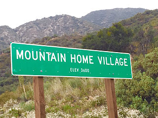
Mountain Home Village is an unincorporated community in San Bernardino County, California, United States with a population of 170 full-time residents as of 2010. Mountain Home Village is located along California State Route 38 5.2 miles (8.4 km) north-northeast of Yucaipa. It is located less than a mile east from the Thurman Flats Picnic Area, and the Loch Leven- and Mill Creek Campgrounds are located in the village. It is also where Mill Creek and Mountain Home Creek meets, while other creeks in area includes Skinner Creek, East Fork Mountain Home Creek, and Frustration Creek. The Mentone Boulders is also located nearby, which is a well-known rock-climbing area. It is located in the San Bernardino Mountains, just at the edge of the San Andreas Fault and offers some extraordinary valley views, and on clear days, also views of the City of San Bernardino. There are also numerous hiking trails located by the village. It is located within the San Bernardino National Forest and is surrounded by pine forest. Its elevation is 3600 feet. In 1956, the Christian Church purchased a resort in Mountain Home Village and started the Loch Leven Camp & Retreat Center.

<span class="mw-page-title-main">Zanja</span> Historical irrigation system used in the American Southwest

A zanja is an archaic irrigation system used in the southwestern United States and that still occurs in various place names as a relic of that time. An acequia is a more highly engineered zanja, able to carry water for longer distances. In some places, sections of a zanja/acequia would be elevated as in an aqueduct. Preserved sections of the Mission Santa Barbara water system demonstrate all three variations.

<span class="mw-page-title-main">Mill Creek Zanja</span> United States historic place

The Mill Creek Zanja, also known as the Zankey, is a historic irrigation canal, or zanja, in Redlands, California. The Serrano people dug the canal in 1819 to provide water from Mill Creek for their farms east of the city. The zanja also provided water for the San Bernardino de Sena Estancia mission outpost, which was built near the canal to access its water. The canal's water became a highly desirable resource in the area; it fueled a local agricultural boom and was the subject of several legal disputes over water rights in the 1800s. The City of Redlands covered the western half of the zanja in the 1920s.

<span class="mw-page-title-main">Guachama Rancheria</span> Historic site in Loma Linda, California

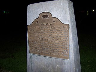
Kaawchama, alternatively referred to as Wa’aachnga, was a significant Tongva village in the San Bernardino Valley located in what is now west Redlands, California. The village became referred to by the Spanish as the Guachama Rancheria in 1810 after a supply station was constructed at the village for Mission San Gabriel, which then became part of Rancho San Bernardino following the secularization of the missions in 1833.

References

  1. 1 2 U.S. Geological Survey Geographic Names Information System: Crafton, California. Retrieved on 2008-07-28.
  2. 1 2 3 4 5 Brown, Jr., John; James Boyd (1922). History of San Bernardino and Riverside Counties. Chicago: Lewis Publishing. p. 220.
  3. Hinckley, Edith Parker (1951). On the Banks of the Zanja: The Story of Redlands. Claremont, California: The Saunders Press. p. 44.
  4. 1 2 3 4 California State University, San Bernardino. etextbooks. George William Beattie. Origin and Early Development of Water Rights in the East San Bernardino Valley November 1951 Archived 2008-05-17 at the Wayback Machine
  5. MSR Maps. USGS The National Map. Redlands, California, United States 7/1/1988
  6. "Southern California Earthquake Data Center. The March 11, 1998 Crafton Hills Earthquake". Archived from the original on June 4, 2008. Retrieved July 26, 2008.
  7. Imaging faults in 3D from earthquakes: the Crafton Hills Fault Zone and the geometry of the San Andreas Fault near San Bernardino, Southern California. S. Carena, L. Yue
  8. Southern California Earthquake Data Center. Crafton Hills Fault Zone Archived 2008-06-26 at the Wayback Machine
  9. USGS. Western Earth Surface Processes Team. San Andreas Fault System in the Inland Empire and Salton Trough. Extensional Fault Zones Archived 2010-05-28 at the Wayback Machine
  10. MountainZone. Crafton Hills Range
  11. Crafton Hills Open Space Conservancy.
  12. 1 2 3 4 A Strategic Plan For The General Redlands Plan Update. Report On Redlands Community Vision City of Redlands. June 2006

34°03′19″N117°07′17″W / 34.0554°N 117.1215°W / 34.0554; -117.1215