Related Research Articles

Murrieta is a city in southwestern Riverside County, California, United States. The population of Murrieta was 103,466 at the 2010 census. Murrieta experienced a 133.7% population increase between 2000 and 2010, according to the most recent census, making Murrieta one of the fastest-growing cities in the state. This population boom in 2010 surpassed the population of the historically larger and more commercial city of Temecula to the south for the first time since the incorporation of either city. Temecula and Murrieta together form the southwestern anchor of the Inland Empire region. Largely residential in character, Murrieta is typically characterized as a commuter town, with many of its residents commuting to jobs in San Diego County, Orange County, Los Angeles County, Temecula, and Camp Pendleton.

Area code 951 is a California telephone area code that was split from area code 909 on July 17, 2004. It covers western Riverside County, including the cities and communities of Beaumont, Corona, Canyon Lake, Riverside, Temescal Canyon, Woodcrest, Arlington, Moreno Valley, Perris, Menifee, Lake Elsinore, Wildomar, Murrieta, Temecula, San Jacinto, Hemet, Lakeview, Nuevo, Norco, Banning, Eastvale, Jurupa Valley, and Idyllwild.

The Kawich Range is a mountain range in Nye County in southern Nevada in the United States, just south of the Hot Creek Range. The southern part of the range lies on the Nellis Air Force Range. The mountains cover an area of about 250 square miles (650 km2) and contain Kawich Peak, at 9,399 feet (2,865 m) above sea level. U.S. Route 6 crosses the pass between The Kawich and the Hot Creek ranges and meets State Route 375 at Warm Springs just north of the range. To the east lies the Reveille and Kawich valleys with the Reveille Range to the east of the northern portion and the Belted Range east of Quartzite Mountain at the southern end. The broad Pahute Mesa and Gold Flat lie to the south with Cactus Flat and the Cactus Range to the southwest. To the northwest across Stone Cabin Valley lies the Monitor Range.

The San Jacinto River is a 42-mile-long (68 km) river in Riverside County, California. The river's headwaters are in San Bernardino National Forest, but the lower portion of the 765-square-mile (1,980 km2) watershed is urban and agricultural land. As a partially endorheic watershed that is contiguous with other Great Basin watersheds, the western side of the San Jacinto Basin is a portion of the Great Basin Divide.
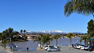
Skinner Reservoir, also known as Lake Skinner, is a reservoir in western Riverside County, California, located at the foot of Bachelor Mountain in the Auld Valley, approximately 10 miles (16 km) northeast of Temecula. It was created in 1973 by the construction of the Skinner Clearwell Dam on Tucalota Creek, and currently has a capacity of 44,200 acre feet (54,500,000 m3). Located just off Rancho California Road, The address of the reservoir is: 37701 Warren Road, Temecula, CA 92592.

The Temecula Valley is a graben rift valley in western Riverside County, California.

French Valley is a region located in southwestern Riverside County, near the cities and communities of Hemet, Winchester, Murrieta, and Temecula in the state of California, United States. It is part of the Plains of Leon, contiguous with the Perris Plain, that drains into the Temecula Basin by means of tributaries of the Santa Margarita River.

The Domenigoni Mountains are a mountain range in Riverside County, California. They lie north of the Menifee Valley and south of the Perris Valley and San Jacinto Valley, west and north of Diamond Valley and north of Domenigoni Valley. The Domenigoni Mountains are composed primarily of metamorphic rock of the Triassic - Jurassic French Valley formation within Searls Ridge and the 1967 foot summit across the saddle to the west of it. The extreme eastern end of Searls Ridge and the western extreme of the 1967 foot summit of the range are Cretaceous granitic rock.
The Rawson Mountains are a mountain range in Riverside County, California. The Rawson Mountains are located south of the Diamond Valley Lake, southeast of Domenigoni Valley, east of French Valley, west of Goodhart Canyon and north of Bachelor Mountain, Auld Valley and Black Mountain. The Rawson Mountains are composed primarily of metamorphic rock of the Triassic - Jurassic French Valley formation, formed as a roof pendant of the Peninsular Range Batholith. The extreme western end of the range and various intrusions within it are Cretaceous granitic rock.

Temescal Creek is an approximately 29-mile-long (47 km) watercourse in Riverside County, in the U.S. state of California. Flowing primarily in a northwestern direction, it connects Lake Elsinore with the Santa Ana River. It drains the eastern slopes of the Santa Ana Mountains on its left and on its right the western slopes of the Temescal Mountains along its length. With a drainage basin of about 1,000 square miles (2,600 km2), it is the largest tributary of the Santa Ana River, hydrologically connecting the 720-square-mile (1,900 km2) San Jacinto River and Lake Elsinore watersheds to the rest of the Santa Ana watershed. However, flowing through an arid rain shadow zone of the Santa Ana Mountains, and with diversion of ground water for human use, the creek today is ephemeral for most of its length, except for runoff from housing developments and agricultural return flows.
Rancho Temecula was a 26,609-acre (107.68 km2) Mexican land grant in present-day Riverside County, California given on 14 December 1844 by Governor Manuel Micheltorena to Feliz Valdez. The grant extended south along the east bank Murrieta Creek to Temecula Creek and encompassed present-day Temecula, Murrieta and Murrieta Hot Springs. At the time of the US patent, Rancho Temecula was a part of San Diego County. Riverside County was created by the California Legislature in 1893 by taking land from both San Bernardino and San Diego Counties.
The Elsinore Mountains are a ridge of mountains within the larger range of the Santa Ana Mountains, in the Cleveland National Forest, Riverside County, California, United States. the tallest peaks within the range is the unofficially named San Mateo Peak at 3,591 ft (1,095 m). Second is officially named Elsinore Peak at 3,536 ft (1,078 m). The Elsinore Mountanins run in a ridge from just east of El Cariso, southeast to Elsinore Peak. Beyond that peak the ridge begins to descend and curves to the east. From Elsinore Peak, a ridge runs to the west and then northwest to San Mateo Peak, enclosing the Morrell Potrero on the south and west.
Leon, now a ghost town, was a gold mining town in northern San Diego County from the 1880s, named for the Leon Mine that lay on a hill to the northwest of the town. Leon became part of southwestern Riverside County in 1893. Leon had its own post office from May 4, 1888 until July 31, 1911 when its post office was moved to Perris, California.
The Elsinore Trough is a graben rift valley in Riverside County, southern California. It is created by the Elsinore Fault Zone.
Temescal Mountains, formerly the Sierra Temescal, are one of the northernmost mountain ranges of the Peninsular Ranges in western Riverside County, in Southern California in the United States. They extend for approximately 25 mi (40 km) southeast of the Santa Ana River east of the Elsinore Fault Zone to the Temecula Basin and form the western edge of the Perris Block.
Temescal Valley in California is a graben rift valley in western Riverside County, California, a part of the Elsinore Trough. The Elsinore Trough is a graben between the Santa Ana Mountain Block to the southwest and the Perris Block on the northeast. It is a complex graben, divided lengthwise into several smaller sections by transverse faults. The Temescal Valley is one of these graben, at the northern end of the trough. The Temescal Valley graben is bounded northeast side by the Lee Lake longitudinal fault and similarly on the southeast by the Glen Ivy Fault.
The Perris Block is the central block of three major fault-bounded blocks of the northern part of the Peninsular Ranges. The Perris Block lies between the Santa Ana Block to the west and the San Jacinto Block to the east. The Perris Block, was named by Walter A. English in 1925 for the city of Perris, located near the center of the block.
Warm Springs Creek is a stream or arroyo, and a tributary of Murrieta Creek, in Riverside County, Southern California.
Willow Springs Station, was a changing station at Alamos or Willow Springs along the Second Division route of the Butterfield Overland Mail, in what is now Murrieta, in Riverside County, California. It was also known as Alamos, Clines's or Kline's, or Willows, was one of the later Butterfield Overland Mail stations, placed in 1859, between some of the original stations for changing teams and providing water between stops in hot dry areas. Willow Springs, also originally known as Alamos Springs was located west of the hills that line the east side of the Temecula Valley, on land of the Rancho Temecula, near Santa Gertrudis Creek on the low flood plain of Murrieta Creek, between Santa Gertrudis and Warm Springs Creek.
Warm Springs Valley is a valley located within the city of Lake Elsinore in Riverside County, California. It lies between the main body of the Temescal Mountains to the north, east and south and the Clevelin Hills to the west. The valley was named for the warm springs that used to be found flowing there.
References
- 1 2 Elmer Wallace Holmes, History of Riverside County, California: With Biographical Sketches of the Leading Men and Women of the County who Have Been Identified with Its Growth and Development from the Early Days to the Present, Historic Record Company, Riverside County, 1912, p.140
- ↑ USGS 1:24K topographic map, Romoland, CA.
- ↑ USGS 1:24K topographic map, Winchester, CA.
Coordinates: 33°37′36″N117°8′3″W / 33.62667°N 117.13417°W
| This Riverside County, California-related article is a stub. You can help Wikipedia by expanding it. |