Related Research Articles

Johannesburg is a census-designated place (CDP) in Kern County, California, in a mining district of the Rand Mountains. Johannesburg is located 1 mile (1.6 km) east-northeast of Randsburg, at an elevation of 3,517 feet (1,072 m). The terminus of the Randsburg Railway was here from 1897 to 1933. The population was 172 at the 2010 census, down from 176 at the 2000 census. Johannesburg is divided from the neighboring community of Randsburg by a ridge. The town is frequently referred to as "Jo-burg" by locals and frequent visitors to the northwest Mojave.

Randsburg is a census-designated place (CDP) in Kern County, California, United States. Randsburg is located 17 miles (27 km) south of Ridgecrest, at an elevation of 3,504 feet (1,068 m). The population was 69 in the 2010 census, down from 77 in the 2000 census.

Stovepipe Wells is a way-station in the northern part of Death Valley, in unincorporated Inyo County, California.

Jenny Lind is an unincorporated community in Calaveras County, California. It lies at an elevation of 253 feet and is located at 38°6′N120°52′W. The community is in ZIP code 95252 and area code 209.
Fourth Crossing is an unincorporated community in Calaveras County, California. It lies at an elevation of 922 feet and is located on State Route 49 at 38°07′53″N120°38′05″W. The community is in ZIP code 95248 and area code 209.

Panamint City is a ghost town in the Panamint Range, near Death Valley, in Inyo County, California, US. It is also known by the official Board of Geographic Names as Panamint. Panamint was a boom town founded after silver and copper were found there in 1872. By 1874, the town had a population of about 2,000. Its main street was one mile (1.6 km) long. Panamint had its own newspaper, the Panamint News. Silver was the principal product mined in the area. The town is located about three miles northwest of Sentinel Peak. According to the National Geographic Names Database, NAD27 latitude and longitude for the locale are 36°07′06″N117°05′43″W, and the feature ID number is 1661185. The elevation of this location is identified as being 6,280 feet AMSL. The similar-sounding Panamint Springs, California, is located about 25.8 miles at 306.4 degrees off true north near Panamint Junction.

Cool, formerly known as Cave Valley, is a small town in El Dorado County, California, about 40 miles (64 km) from Sacramento, the state capital. Cool is at an elevation of 1,532 feet.
Ogilby is a ghost town in Imperial County, California, United States. Ogilby is located on the Southern Pacific Railroad 42 miles (68 km) east of El Centro, and 3.8 miles (6.1 km) north of Interstate 8 on County Road S34. The name is official for federal use, and a feature ID number of 252950 has been assigned. Ogilby is defined by the US Geological Survey as a populated place at 356 feet (109 m) AMSL elevation. NAD27 latitude and longitude are listed at 32°49′01″N114°50′20″W on the "Ogilby, California" 7.5-minute quadrangle (map). It is included in the Imperial County Air Pollution Control District. It lies at an elevation of 364 feet (111 m).

French Corral is an unincorporated community approximately five miles west of California State Highway 49 in Nevada County, California.

Castle Dome Landing, Arizona is a ghost town in the Castle Dome Mountains of Yuma County in the U.S. state of Arizona. It was first settled as a transport depot and mining camp around 1863 in what was then the Arizona Territory.

Rohnerville is an unincorporated community in Humboldt County, California. It is located 2.25 miles (3.6 km) southeast of Fortuna, at an elevation of 197 feet.
Banner is an unincorporated community in San Diego County, California. It lies at an elevation of 2743 feet. It is located on State Highway 78.

Aubrey Landing, Aubrey City or Aubrey is a ghost town at the mouth of the Bill Williams River in southern Mohave County, Arizona, United States. The town was founded before 1865 and was abandoned sometime after 1886. Aubrey Landing was inundated when Lake Havasu was formed.
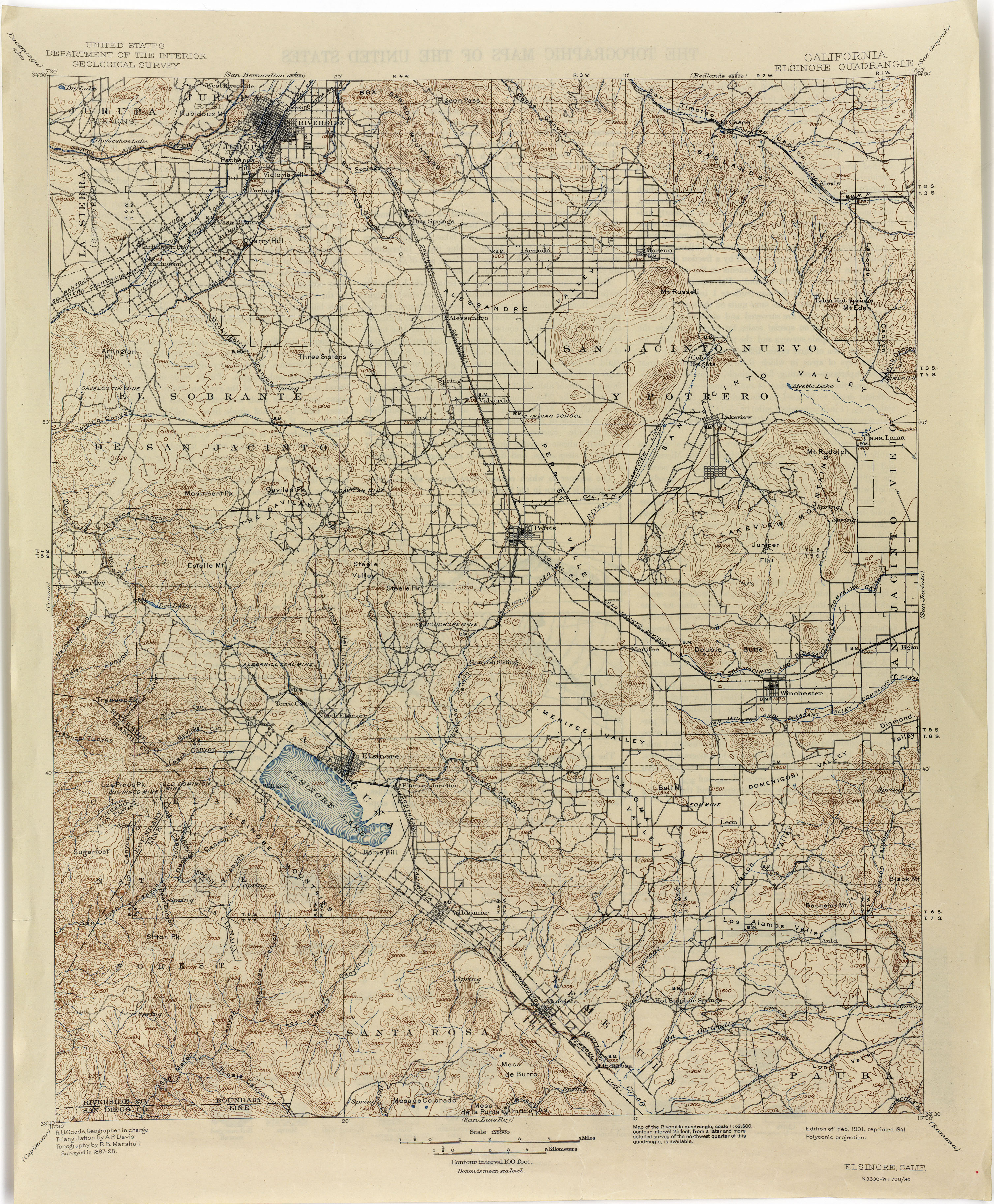
Alberhill is an unincorporated community in Riverside County, California. Alberhill is located 5.5 miles (8.9 km) northwest of Lake Elsinore. It lies at an elevation of 1234 feet. Alberhill was named after C.H. Albers and James and George Hill.
Branson City or Branson is a ghost town in San Diego County, California. It lies at an elevation of 3996 feet. It is located on State Highway 78 at its junction with Pine Hills Road, about one mile west of Julian.
Carbondale, in Orange County, California, is a historical coal mining town in Santiago Canyon, where Santiago Creek had its confluence with Silverado Creek in Silverado, California. It had a post office from May 11, 1881, to January 29, 1884, when it was closed and mail sent to the Santa Ana post office.

Temescal Mountains, formerly the Sierra Temescal, are one of the northernmost mountain ranges of the Peninsular Ranges in western Riverside County, in Southern California in the United States. They extend for approximately 25 mi (40 km) southeast of the Santa Ana River east of the Elsinore Fault Zone to the Temecula Basin and form the western edge of the Perris Block.
The Plains of Leon are named for the former gold mining town, Leon once located near the middle of the plain. It is a plain in the Perris Block, contiguous on the south with the Perris Plain including within it the Domenigoni Valley and western Diamond Valley, French Valley, Auld Valley, the upper part of the valley of Warm Springs Creek and connecting tablelands.
Gavilan Hills, sometimes called the Gavilan Mountains, are a range of the Temescal Mountains, in Riverside County, California. The name given them came from local New Mexican and Californio miners of the mountains and Gavilan Plateau. In Spanish Gavilan, means "sparrow hawk".
Gavilan Plateau is a plateau in Riverside County, California. It lies at an elevation of 2083 feet on the north slope of the Temescal Mountains overlooking the Cajalco Valley south of Riverside, California.
References
- ↑ U.S. Geological Survey Geographic Names Information System: Leon Mine at 33°39′09″N117°08′08″W / 33.65250°N 117.13556°W
- ↑ Frickstad, Walter N., A Century of California Post Offices 1848–1954, Philatelic Research Society, Oakland, CA. 1955, pp. 126–135.
- ↑ Perry–Castañeda Library Map Collection, California Topographic Maps, Elsinore 1898 1:125,000 (3.7MB)
- ↑ Leon, California, USGS Map Name: Winchester, CA Map Center: 33°38′29″N117°06′49″W / 33.64139°N 117.11361°W
Coordinates: 33°38′29″N117°6′49″W / 33.64139°N 117.11361°W

| | This Riverside County, California-related article is a stub. You can help Wikipedia by expanding it. |