The Cahuilla, also known as ʔívil̃uqaletem or Ivilyuqaletem, are a Native American people of the various tribes of the Cahuilla Nation, living in the inland areas of southern California. Their original territory included an area of about 2,400 square miles (6,200 km2). The traditional Cahuilla territory was near the geographic center of Southern California. It was bounded to the north by the San Bernardino Mountains, to the south by Borrego Springs and the Chocolate Mountains, to the east by the Colorado Desert, and to the west by the San Jacinto Plain and the eastern slopes of the Palomar Mountains.

The San Bernardino de Sena Estancia was a ranch outpost of Mission San Gabriel Arcángel in what is now Redlands, California, United States. It was built to graze cattle, and for Indian reductions of the Serrano people and Cahuilla people into Mission Indians. Over time, it fell into disrepair, until the early 20th century, when a new, larger structure was built as a museum. The new structure shares the same architectural style, but is not otherwise similar to the original buildings.

The Old Spanish Trail is a historical trade route that connected the northern New Mexico settlements of Santa Fe, New Mexico with those of Los Angeles, California and southern California. Approximately 700 mi (1,100 km) long, the trail ran through areas of high mountains, arid deserts, and deep canyons. It is considered one of the most arduous of all trade routes ever established in the United States. Explored, in part, by Spanish explorers as early as the late 16th century, the trail was extensively used by traders with pack trains from about 1830 until the mid-1850s. The area was part of Mexico from Mexican independence in 1821 to the Mexican Cession to the United States in 1848.

The Temecula massacre took place in December 1846 east of present-day Temecula, California, United States. It was part of a series of related events in the Mexican–American War. A combined force of Californio militia and Cahuilla Indians attacked and killed an estimated 33 to 40 Luiseño Indians. The Mexican authorities in California took the military action in retaliation for the Indians' killing 11 Californio lancers, in what was called the Pauma Massacre.
The Lugo family of California were prominent during the periods of Spanish and Mexican rule. They were among the early colonists who became known as Californios.

San Bernardino, California, was named in 1810.
The California Inland Empire Council (CIEC) of the Boy Scouts of America serves the Inland Empire of California. The service area comprises San Bernardino and Riverside Counties. People interested in joining scouting can go to BeaScout.org. The CIEC is headquartered in Redlands California where it has office and a Scout Shop.

San Timoteo Canyon is a river valley canyon southeast of Redlands, in the far northwestern foothills of the San Jacinto Mountains in the Inland Empire region of Southern California.
Rancho El Rincón was a 4,431-acre (17.93 km2) Mexican land grant in present-day San Bernardino County and Riverside County, California given in 1839 to Juan Bandini by Governor Juan Alvarado. El rincón means "the corner" in Spanish. The grant, located south of present-day Chino, was bounded on the east by Rancho Jurupa, on the south by the Santa Ana River, on the west by Rancho Cañón de Santa Ana, and extending northerly from the river one league. The rancho lands include Prado Regional Park.
Rancho San Jacinto y San Gorgonio was a 4,440-acre (18.0 km2) Mexican land grant in present-day Riverside County, California given in 1843 by Governor Manuel Micheltorena to James (Santiago) Johnson. At the time of the US Patent, Rancho San Jacinto y San Gorgonio was a part of San Bernardino County. The County of Riverside was created by the California Legislature in 1893 by taking land from both San Bernardino and San Diego Counties. The grant encompassed San Timoteo Canyon.

Rancho Temescal was a farming outpost of Mission San Luis Rey de Francia, one of the 21 Franciscan missions established in California by Spain during the late 18th and early 19th centuries. The Mission was located on the coast where Oceanside, California is today. The Rancho was settled in 1819 by Leandro Serrano, and became the first non-native settlement within the boundaries of what would become Riverside County, California.
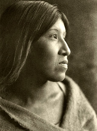
Juan Antonio (1783–1863), Cahuilla name: Cooswootna, Yampoochee,, was a major chief of the Mountain Band of the Cahuilla from the 1840s to 1863.
Politana or Apolitana was the first Spanish settlement in the San Bernardino Valley of California. It was established as a mission chapel and supply station by the Mission San Gabriel in the a rancheria of the Guachama Indians that lived on the bluff that is now known as Bunker Hill, near Lytle Creek. Besides the Guachama, it was also at various times the home for colonists from New Mexico and Cahuilla people. Its most prominent landmark today is the St. Prophet Elias Greek Orthodox Church on Colton Avenue, just southwest of the Inland Center Mall, in San Bernardino, California.
San Timoteo Creek is a stream in Riverside and San Bernardino counties in southern California, United States. A tributary of the Santa Ana River, it flows through San Timoteo Canyon. San Timoteo Creek has a drainage basin of about 125 square miles (320 km2). The creek receives most of its water from headwater tributaries flowing from the San Bernardino Mountains near Cherry Valley, as well as Yucaipa Creek, which flows from Live Oak Canyon.

Glen Helen Regional Park is a county park located in San Bernardino, California, United States adjacent to the Cajon Pass. It was the site of both US Festivals of the early 1980s. It is also home to the Glen Helen Amphitheater, the largest outdoor amphitheater in the United States. The park also hosts several off-road races since 1985.

Kaawchama, alternatively referred to as Wa’aachnga, was a significant Tongva village in the San Bernardino Valley located in what is now west Redlands, California. The village became referred to by the Spanish as the Guachama Rancheria in 1810 after a supply station was constructed at the village for Mission San Gabriel, which then became part of Rancho San Bernardino following the secularization of the missions in 1833.

Tapia Adobe was the home of Tiburcio Tapia (1789–1845). Tiburcio Tapia was a Mexican soldier, politician, then became a merchant, winery owner and ranch owner, in what is now Cucamonga, California. The place of Tapia Adobe (home) was designated a California Historic Landmark (No.360) on October 9, 1939. Tiburcio Tapía received the land to build his Adobe and Rancho Cucamonga from a 1839 13,045-acre (52.79 km2) Mexican land grant in present-day San Bernardino County, California The land grant was from Mexican governor Juan Bautista Alvarado. The grant formed parts of present-day Rancho Cucamonga and Upland. It extended easterly from San Antonio Creek to what is now Hermosa Avenue, and from today's Eighth Street to the mountains.

The Mormon Trail Monument was designated a California Historic Landmark (No.577). The Monument is to remember the 500 Mormon pioneers came to the San Bernardino Valley in June 1851. The Monument is near Phelan, California in San Bernardino County, California. The Monument was built in 1937 and is on California State Route 138, 3.6 Miles West of Interstate 15. In 1857 about half the Mormons were told to return to Utah during the Mormon War, also call the Utah War. the Mormon War, or the Mormon Rebellion


