Related Research Articles

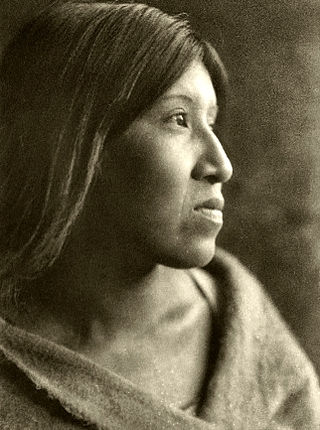
The Cahuilla, also known as ʔívil̃uqaletem or Ivilyuqaletem, are a Native American people of the various tribes of the Cahuilla Nation, living in the inland areas of southern California. Their original territory encompassed about 2,400 square miles (6,200 km2). The traditional Cahuilla territory was near the geographic center of Southern California. It was bounded to the north by the San Bernardino Mountains, to the south by Borrego Springs and the Chocolate Mountains, to the east by the Colorado Desert, and to the west by the San Jacinto Plain and the eastern slopes of the Palomar Mountains.

The Cahuilla Band of Indians is a federally recognized tribe of Cahuilla people located in Southern California. They were formerly the Cahuilla Band of Cahuilla Indians of the Cahuilla Reservation.

The Sycuan Band of the Kumeyaay Nation is a federally recognized tribe of Mission Indians from Southern California, located in an unincorporated area of San Diego County just east of El Cajon. The Sycuan band are a Kumeyaay tribe, one of the four ethnic groups indigenous to San Diego County.
The Agua Caliente Band of Cahuilla Indians of the Agua Caliente Indian Reservation is a federally recognized tribe of the Cahuilla, located in Riverside County, California, United States. The Cahuilla inhabited the Coachella Valley desert and surrounding mountains between 5000 BCE and 500 CE. With the establishment of the reservations, the Cahuilla were officially divided into 10 sovereign nations, including the Agua Caliente Band.
The Augustine Band of Cahuilla Indians is a federally recognized Cahuilla band of Native Americans based in Coachella, California. They are one of the smallest tribal nations in the United States, consisting of only 16 members, seven of whom are adults.
The Big Lagoon Rancheria is a federally recognized tribe of Yurok and Tolowa Indians. They are located in Humboldt County, California, and their tribal headquarters is in Arcata, California.
The Twenty-Nine Palms Band of Mission Indians of California is a federally recognized tribe of Mission Indians with a reservation consisting of two sections, one located near the cities of Indio and Coachella in Riverside County, and the other in the city of Twentynine Palms in San Bernardino County, California. While many scholars regard the tribe as being Luiseño, the tribe itself identifies as being Chemehuevi.

The Ramona Band of Cahuilla is a federally recognized tribe of Cahuilla Indians, located in Riverside County, California.
The Santa Rosa Band of Cahuilla Indians is a federally recognized tribe of Cahuilla Indians, located in Riverside County, California.
The Torres Martinez Desert Cahuilla Indians is a federally recognized tribe of Cahuilla Indians, located in Imperial and Riverside counties in California. Their autonym is Mau-Wal-Mah Su-Kutt Menyil, which means "among the palms, deer moon." in the Cahuilla language.

Los Coyotes Band of Cahuilla and Cupeño Indians of the Los Coyotes Reservation is a federally recognized tribe of Cahuilla and Cupeño Indians, who were Mission Indians located in California.

The Morongo Band of Mission Indians is a federally recognized tribe in California, United States. The main tribal groups are Cahuilla and Serrano. Tribal members also include Cupeño, Luiseño, and Chemehuevi Indians. Although many tribes in California are known as Mission Indians, some, such as those at Morongo, were never a part of the Spanish Missions in California.

The Santa Ysabel Band of Diegueño Mission Indians of the Santa Ysabel Reservation is a federally recognized tribe of Kumeyaay Indians, who are sometimes known as Mission Indians.

The San Pasqual Band of Diegueño Mission Indians of California is a federally recognized tribe of Kumeyaay people, who are sometimes known as Mission Indians.

The Mesa Grande Band of Diegueño Mission Indians of the Mesa Grande Reservation is a federally recognized tribe of Kumeyaay Indians, who are sometimes known as Mission Indians.

The Manzanita Band of Diegueño Mission Indians of the Manzanita Reservation is a federally recognized tribe of Kumeyaay Indians, who are sometimes known as part of the Mission Indians.

The La Posta Band of Diegueño Mission Indians of the La Posta Reservation is a federally recognized tribe of the Kumeyaay Indians, who are sometimes known as Mission Indians.

The Barona Group of Capitan Grande Band of Mission Indians of the Barona Reservation is a federally recognized tribe of Kumeyaay Indians, who are sometimes known as Mission Indians.

The Viejas Group of Capitan Grande Band of Mission Indians of the Viejas Reservation, also called the Viejas Band of Kumeyaay Indians, is a federally recognized tribe of Kumeyaay Indians.
The Table Mountain Rancheria is a federally recognized tribe of Native American people from the Chukchansi band of Yokuts and the Monache tribe. It is also the tribe's ranchería, located in Fresno County, California.
References
- 1 2 3 4 California Indians and Their Reservations. Archived January 4, 2016, at the Wayback Machine San Diego State University Library and Information Access. 2011. Retrieved 1 Nov 2012.
- ↑ Eargle, 111
- 1 2 3 Pritzker, 120
- ↑ Indian Affairs Bureau (January 12, 2023). "Indian Entities Recognized by and Eligible To Receive Services From the United States Bureau of Indian Affairs". Federal Register. 88: 2112–16. Retrieved February 5, 2023.
- ↑ "Cabazon Band elects Douglas Welmas as its new chairman." indianz.com. (retrieved 10 Dec 2014)
- ↑ "Fantasy Springs Resort Casino." 500 Nations. (retrieved 14 May 2010)
- ↑ "Golf." Archived October 2, 2013, at the Wayback Machine Fantasy Springs Resort Casino. 2010 (retrieved 14 May 2010)
- ↑ "Cabazon Indians." Archived May 28, 2010, at the Wayback Machine Cabazon Band of Mission Indians. 2010 (retrieved 14 May 2010)
- ↑ Lane, Ambrose I. (1995). Return of the Buffalo: The Story Behind America's Indian Gaming Explosion. Greenwood Publishing Group. pp. 174–175. ISBN 0-89789-433-2. (See section: (iii.) Bua Report, "Riconosciuto's March 29, 1981 (sic) arrest".
- ↑ Amy Taxin; Gillian Flaccus (January 21, 2010). "Arrest in 1981 tribal murders revives old mystery". Newsday. Associated Press. Retrieved November 25, 2010.
