Valle Vista, California

Last updated

Valle Vista, California
Orange Groves and San Jacinto Mountains in Valle Vista, California.jpg
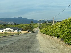
Orange groves and view of San Jacinto Mountains in Valle Vista, California
Riverside County California Incorporated and Unincorporated areas Valle Vista Highlighted.svg
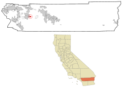
Location in Riverside County and the state of California
Usa edcp location map.svg
Red pog.svg
Valle Vista, California
Location in the United States
Coordinates: 33°45′10″N116°53′53″W / 33.75278°N 116.89806°W / 33.75278; -116.89806
CountryUnited States
State California
County Riverside
Area
[1]
  Total7.076 sq mi (18.328 km2)
  Land6.868 sq mi (17.789 km2)
  Water0.208 sq mi (0.540 km2)  2.94%
Elevation
[2]
1,775 ft (541 m)
Population
 (2010)
  Total11,036
  Density1,600/sq mi (600/km2)
Time zone UTC-8 (PST)
  Summer (DST) UTC-7 (PDT)
ZIP code
92544
Area code(s) 909, 951
FIPS code 06-81708
GNIS feature ID 1652805

Valle Vista (Spanish for "View Valley") is a unincorporated area in Riverside County, California, United States and is located in the San Jacinto Valley. Valle Vista is adjacent to and east of the cities of San Jacinto and Hemet. The population was 11,036 at the 2010 census, up from 8,356 at the 2000 census. For statistical purposes, the United States Census Bureau has defined Valle Vista as a census-designated place (CDP).

Contents

Geography

According to the United States Census Bureau, the CDP has a total area of 7.1 square miles (18 km2), of which, 6.9 square miles (18 km2) of it is land and 0.2 square miles (0.52 km2) of it (2.94%) is water.

Surrounding communities

Climate

Valle Vista, generally has year-round pleasant weather, with hot summers and mild, wet winters. On average, the warmest month is August. The highest recorded temperature was 115 °F (46 °C) in 2004. On average, the coolest month is December. The lowest recorded temperature was 9 °F (−13 °C) in 1974. The maximum average precipitation occurs in February.

Climate data for Valle Vista, Ca
MonthJanFebMarAprMayJunJulAugSepOctNovDecYear
Record high °F (°C)91
(33)
90
(32)
99
(37)
103
(39)
110
(43)
111
(44)
114
(46)
115
(46)
112
(44)
104
(40)
95
(35)
90
(32)
114
(46)
Mean daily maximum °F (°C)67
(19)
67
(19)
71
(22)
74
(23)
80
(27)
89
(32)
96
(36)
98
(37)
93
(34)
83
(28)
73
(23)
66
(19)
80
(27)
Mean daily minimum °F (°C)37
(3)
39
(4)
43
(6)
46
(8)
51
(11)
56
(13)
61
(16)
62
(17)
56
(13)
51
(11)
42
(6)
36
(2)
48
(9)
Record low °F (°C)9
(−13)
19
(−7)
26
(−3)
31
(−1)
37
(3)
41
(5)
46
(8)
44
(7)
42
(6)
31
(−1)
24
(−4)
13
(−11)
9
(−13)
Average precipitation inches (mm)2.69
(68)
2.79
(71)
1.92
(49)
0.80
(20)
0.40
(10)
0.09
(2.3)
0.18
(4.6)
0.17
(4.3)
0.32
(8.1)
0.61
(15)
0.90
(23)
1.74
(44)
12.61
(320)
Source: [3]

Demographics

2010

At the 2010 census Valle Vista had a population of 11,036. The population density was 2,060.0 inhabitants per square mile (795.4/km2). The racial makeup of Valle Vista was (69.2%) White, (13.0%) African American,(1.7%) Native American,(1.9%) Asian,(0.3%) Pacific Islander,(9.3%) from other races, and (4.6%) from two or more races. Hispanic or Latino (27.6%). [4]

The census reported that 11,036 people (100% of the population) lived in households, 5 (0%) lived in non-institutionalized group quarters, and no one was institutionalized.

There were 5,464 households, 1,762 (32.2%) had children under the age of 18 living in them, 2,738 (50.1%) were opposite-sex married couples living together, 693 (12.7%) had a female householder with no husband present, 327 (6.0%) had a male householder with no wife present. There were 335 (6.1%) unmarried opposite-sex partnerships, and 31 (0.6%) same-sex married couples or partnerships. 1,410 households (25.8%) were one person and 794 (14.5%) had someone living alone who was 65 or older. The average household size was 2.67. There were 3,758 families (68.8% of households); the average family size was 3.20.

The age distribution was 3,630 people (24.9%) under the age of 18, 1,188 people (8.1%) aged 18 to 24, 3,126 people (21.4%) aged 25 to 44, 3,804 people (26.1%) aged 45 to 64, and 2,830 people (19.4%) who were 65 or older. The median age was 41.4 years. For every 100 females, there were 91.9 males. For every 100 females age 18 and over, there were 90.7 males.

There were 6,112 housing units at an average density of 863.7 per square mile, of the occupied units 4,129 (75.6%) were owner-occupied and 1,335 (24.4%) were rented. The homeowner vacancy rate was 4.4%; the rental vacancy rate was 9.8%. 10,384 people (71.2% of the population) lived in owner-occupied housing units and 4,189 people (28.7%) lived in rental housing units.

2000

At the 2000 census there were 8,356 people, 4,510 households, and 2,963 families in the CDP. The population density was 3,269.7 inhabitants per square mile (1,262.4/km2). There were 5,009 housing units at an average density of 1,530.4 per square mile (590.9/km2). The racial makeup of the CDP was 78.6% White, 12.2% African American, 3.3% Native American, 1.3% Asian, 0.2% Pacific Islander, 1.9% from other races, and 2.6% from two or more races. Hispanic or Latino of any race were 13.7%. [5]

Of the 4,510 households 23.2% had children under the age of 18 living with them, 53.8% were married couples living together, 8.8% had a female householder with no husband present, and 34.3% were non-families. 30.3% of households were one person and 21.1% were one person aged 65 or older. The average household size was 2.3 and the average family size was 2.9.

The age distribution was 22.3% under the age of 18, 5.5% from 18 to 24, 20.6% from 25 to 44, 19.9% from 45 to 64, and 31.7% 65 or older. The median age was 46 years. For every 100 females, there were 88.2 males. For every 100 females age 18 and over, there were 84.0 males.

The median household income was $32,455 and the median family income was $44,504. Males had a median income of $45,765 versus $26,250 for females. The per capita income for the CDP was $18,130. About 8.6% of families and 11.7% of the population were below the poverty line, including 17.0% of those under age 18 and 7.7% of those age 65 or over.

Government

In the California State Legislature, Valle Vista is in the 28th Senate District , represented by Democrat Lola Smallwood-Cuevas, and the 71st Assembly District , represented by Republican Kate Sanchez. [6]

In the United States House of Representatives, Valle Vista is in California's 36th congressional district , represented by Democrat Ted Lieu. [7]

Parks and recreation

Deputy Brett M. Harris Park is a county park at 25175 Fairview Ave named after a member of the Riverside County Sheriff's Department who served the community. He died from a traffic crash while on duty. [8]

Related Research Articles

<span class="mw-page-title-main">Whetstone, Arizona</span> CDP in Cochise County, Arizona

Whetstone is a census-designated place (CDP) in Cochise County, Arizona, United States, north of Sierra Vista. The population was 2,617 at the 2010 census.

<span class="mw-page-title-main">Mesa Vista, California</span> Census-designated place in California, United States

Mesa Vista is a census-designated place (CDP) in Alpine County, California, United States. The population was 200 at the 2010 census, up from 182 at the 2000 census.

<span class="mw-page-title-main">Laton, California</span> Census-designated place in California, United States

Laton is a census-designated place (CDP) in Fresno County, California, United States. The population was 1,824 at the 2010 census, up from 1,236 at the 2000 census. Laton is located 23 miles (37 km) south-southeast of Fresno, at an elevation of 259 feet.

<span class="mw-page-title-main">Derby Acres, California</span> Census-designated place in California, United States

Derby Acres is a census-designated place (CDP) in Kern County, California, United States. Derby Acres is located 5.5 miles (8.9 km) north-northwest of Fellows, at an elevation of 1,375 feet (419 m). The population was 322 at the 2010 census, down from 376 at the 2000 census. The town is on State Route 33 at the northern extremity of the Midway-Sunset Oil Field, about five miles (8 km)five miles southeast of McKittrick.

<span class="mw-page-title-main">Madera Acres, California</span> Census-designated place in California, United States

Madera Acres is a census-designated place (CDP) in Madera County, California, United States. It is part of the Madera Metropolitan Statistical Area. The population was 9,162 at the 2020 census, virtually unchanged from 2010.

<span class="mw-page-title-main">Parkwood, California</span> Census-designated place in California, United States

Parkwood is a census-designated place (CDP) in Madera County, California, United States. It is part of the Madera Metropolitan Statistical Area. The population was 2,307 at the 2020 census.

<span class="mw-page-title-main">Meadow Vista, California</span> Census-designated place in California, United States

Meadow Vista is a census-designated place (CDP) in Placer County, California, United States. It is part of the Sacramento–Arden-Arcade–Roseville Metropolitan Statistical Area. The population was 3,217 at the 2010 census, up from 3,096 at the 2000 census.

<span class="mw-page-title-main">Tahoe Vista, California</span> Census-designated place in California, United States

Tahoe Vista is a census-designated place located on the north shore of Lake Tahoe in Placer County, California. It is part of the Sacramento–Arden-Arcade–Roseville Metropolitan Statistical Area. The population was 1,433 at the 2010 census, down from 1,668 at the 2000 census.

<span class="mw-page-title-main">Belden, California</span> Census-designated place in California, United States

Belden is a census-designated place (CDP) in Plumas County, California, United States. Belden is located on the Feather River Route and the North Fork Feather River, 7 miles (11.3 km) southwest of Caribou. The population was 22 at the 2010 census, down from 26 in 2000.

<span class="mw-page-title-main">Mohawk Vista, California</span> Census-designated place in California, United States

Mohawk Vista is a census-designated place in Plumas County, California, United States. The population was 159 at the 2010 census, up from 121 at the 2000 census.

<span class="mw-page-title-main">Bonsall, California</span> Census-designated place in California, United States

Bonsall is a census-designated place (CDP) in San Diego County, California. The population was 3,982 at the 2010 census, up from 3,401 at the 2000 census.

<span class="mw-page-title-main">Camp Pendleton Mainside, California</span> Census-designated place in California, United States

Camp Pendleton Mainside is a census-designated place (CDP) in San Diego County, California, located at the southeast corner of the Marine Corps Base Camp Pendleton. Per the 2020 census, the population was 9,683. It was formerly known as Camp Pendleton North, but its name was changed for the 2020 Census. Along with Camp Pendleton South, it is one of two CDPs located on the base.

<span class="mw-page-title-main">La Presa, California</span> Census-designated place in California, United States

La Presa is a census-designated place (CDP) in the East County region of San Diego County, California, United States. The population was 34,169 at the 2010 census, up from 32,721 at the 2000 census.

<span class="mw-page-title-main">Ducor, California</span> Census-designated place in California, United States

Ducor is a census-designated place (CDP) in Tulare County, California, United States. The population was 616 at the 2020 census, up from 612 at the 2010 census. Ducor is an abbreviation of an earlier name, Dutch Corners, which was given because several early settler families were German. The word "Dutch" in this case derives from German deutsch "German".

<span class="mw-page-title-main">Mono Vista, California</span> Census-designated place in California, United States

Mono Vista is a census-designated place (CDP) in Tuolumne County, California, United States. The population was 3,127 at the 2010 census, up from 3,072 at the 2000 census.

<span class="mw-page-title-main">Lake Asbury, Florida</span> Census-designated place in Florida, United States

Lake Asbury is an unincorporated community and census-designated place (CDP) in Clay County, Florida, United States. It is referred to as the Asbury Lake CDP by the U.S. Census Bureau. The population at the 2020 census was 11,036, up from 8,700 at the 2010 census. It is part of the Jacksonville, Florida Metropolitan Statistical Area.

<span class="mw-page-title-main">Vista Center, New Jersey</span> Populated place in Ocean County, New Jersey, US

Vista Center is an unincorporated community and census-designated place (CDP) located within Jackson Township in Ocean County, in the U.S. state of New Jersey. As of the 2010 United States Census, the CDP's population was 3,689.

<span class="mw-page-title-main">El Valle de Arroyo Seco, New Mexico</span> CDP in New Mexico, United States

El Valle de Arroyo Seco is a census-designated place (CDP) in Santa Fe County, New Mexico, United States. It is part of the Santa Fe, New Mexico Metropolitan Statistical Area. The population was 1,440 at the 2010 census.

<span class="mw-page-title-main">Garfield, Texas</span> CDP in Texas, United States

Garfield is a census-designated place (CDP) in Travis County, Texas, United States. As of the 2020 census, the CDP population was 1,825.

Vista Santa Rosa is a census-designated place in Riverside County, California. Vista Santa Rosa sits at an elevation of 69 feet (21 m) below sea level. The 2010 United States census reported Vista Santa Rosa's population was 2,926.

References

  1. "2010 Census U.S. Gazetteer Files – Places – California". United States Census Bureau.
  2. "Valle Vista". Geographic Names Information System . United States Geological Survey, United States Department of the Interior . Retrieved November 11, 2014.
  3. "Monthly Averages and Record Temperatures for Valle Vista, CA". The Weather Channel. 2011. Retrieved December 22, 2011.
  4. "2010 Census Interactive Population Search: CA - Valle Vista CDP". U.S. Census Bureau. Archived from the original on July 15, 2014. Retrieved July 12, 2014.
  5. "U.S. Census website". United States Census Bureau . Retrieved January 31, 2008.
  6. "Statewide Database". Regents of the University of California. Archived from the original on February 1, 2015. Retrieved March 16, 2015.
  7. "California's 36th Congressional District - Representatives & District Map". Civic Impulse, LLC.
  8. "Hemet-area park renamed for fallen Riverside County sheriff's deputy". Press Enterprise. City News Service. January 23, 2024. Retrieved January 24, 2024.