La Cresta is an unincorporated community in the Santa Rosa Plateau region in Riverside County, California, United States. It is situated west of Murrieta, north of Temecula and the San Diego County Border, and east of Orange County. It is centrally located approximately 55 miles from Downtown San Diego, 65 miles from Downtown Los Angeles, and 15 miles from the Pacific Ocean. The population of La Cresta is approximately 2,860.
History
Like many areas in California, prior to being developed, La Cresta was home to native American tribes whose artifacts and remnants can still be found today. Unlike the neighboring cities of Murrieta and Temecula which experienced significant growth in the late 1880s, early 1900s, and throughout the 1990s, La Cresta remained largely undisturbed. In 1971, as the valley matured and more people moved in, Dan Stephenson, Founder and Chairman of the Rancon Group, moved into land and estate sales. One of his first major developments was La Cresta. Stephenson's group master-planned La Cresta to include estate properties linked by riding and walking trails. The venture was a success and set the tone for future area development including the La Cresta Highlands and Santa Rosa West.
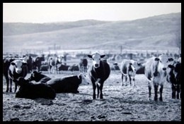
La Cresta is characterized by its exclusive equestrian ranches and large luxurious estates. Comprising 5,900-acres, La Cresta is made up of five separate Home Owner Associations including: La Cresta, La Cresta Highlands, Santa Rosa West, The Trails, and Meadow Oaks.
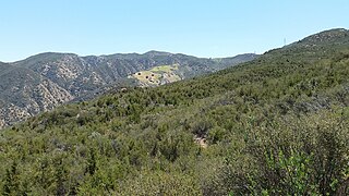
Despite a number of ranches and estates in the community, much of La Cresta remains in its natural undeveloped state. Expansive views of the Cleveland National Forest, Santa Rosa Plateau, Santa Ana Mountains, Mount Palomar, and Pacific Ocean are commonplace. Groves of ancient oak trees and meandering spring-fed creeks dot the valleys as green orchards and vineyards quilt the rolling hills. Sitting at an elevation between 1,800 and 2,700 feet above sea level, La Cresta benefits from a temperate year-round climate that is approximately 10 degrees cooler than the Murrieta/Temecula Valley.
La Cresta is home to a vast wildlife population including California mule deer, coyotes, mountain lions, bobcats, gray fox, jackrabbits, snakes, racoons, squirrels, and skunks. Bird populations in the community are healthy and plentiful and include several species of hawks, golden eagle, owls, and numerous songbirds.
The TrailsLa CrestaLa Cresta HighlandsSanta Rosa WestMeadow Oaks
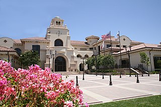
Temecula is a city in southwestern Riverside County, California, United States. The city had a population of 110,003 as of the 2020 census and was incorporated on December 1, 1989. The city is a tourist and resort destination, with the Temecula Valley Wine Country, Old Town Temecula, the Temecula Valley Balloon & Wine Festival, the Temecula Valley International Film Festival, championship golf courses, and resort accommodations contributing to the city's economic profile.
The Santa Ana Mountains are a short peninsular mountain range along the coast of Southern California in the United States. They extend for approximately 61 miles (98 km) southeast of the Los Angeles Basin largely along the border between Orange and Riverside counties.
The Santa Margarita River which with the addition of what is now Temecula Creek, was formerly known as the Temecula River, is a short intermittent river on the Pacific coast of southern California in the United States, approximately 30.9 miles (49.7 km) long. One of the last free-flowing rivers in southern California, it drains an arid region at the southern end of the Santa Ana Mountains, in the Peninsular Ranges between Los Angeles and San Diego.
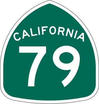
State Route 79 (SR 79) is an approximately 106-mile (171 km) north-south state highway in the U.S. state of California. The highway's southern terminus is at Interstate 8 (I-8) at the Descanso Junction in San Diego County. Its northern terminus is at Interstate 10 (I-10) in the city of Beaumont in Riverside County. In San Diego County, SR 79 connects with Lake Cuyamaca and Cuyamaca Rancho State Park, the communities of Julian and Warner Springs. In Riverside County, the highway runs through the cities of Temecula, Murrieta, Hemet, and San Jacinto before reaching Beaumont.
California's 48th congressional district is a congressional district in the U.S. state of California based in San Diego County in Southern California. It is currently represented by Republican Darrell Issa.
The Santa Rosa Plateau is an upland plateau and southeastern extension of the Santa Ana Mountains in Riverside County, southern California. It is bounded by the rapidly urbanizing Inland Empire cities of Murrieta and Temecula to the northeast and southeast, respectively.
Temecula Creek, formerly known as the Temecula River, runs 32.6 miles (52.5 km) through southern Riverside County, California, United States, past the rural communities of Radec and Aguanga, and ending 0.5 miles (0.80 km) southeast of the original city center of Temecula. The creek is filled with boulders and is typically dry and sandy. It is a relatively undeveloped coastal-draining watershed. Until the 1920s, water flowed in Temecula Creek year-round.
The Southern California Association of Governments (SCAG) is the Metropolitan Planning Organization (MPO) of six of the ten counties in Southern California, serving Imperial County, Los Angeles County, Orange County, Riverside County, San Bernardino County, and Ventura County. San Diego County's MPO is the San Diego Association of Governments, which is an unrelated agency.
Warner Springs is set of springs and a small unincorporated community in northern San Diego County, California. Warner Springs is on the Pacific Crest Trail.
Redonda Mesa is a mesa type formation located in the southern Santa Ana Mountains, near the Pacific Ocean in Southern California. It is located in an unincorporated area of southwestern Riverside County.
Rancho Santa Rosa was a 47,815-acre (193.50 km2) Mexican land grant in present day Riverside County, California given in 1846 by Governor Pio Pico to Juan Moreno. At the time of the US patent, Rancho Santa Rosa was a part of San Diego County. Riverside County was created by the California Legislature in 1893 by taking land from both San Bernardino and San Diego Counties. The site is now registered as a California Historical Landmark.
De Luz is an unincorporated community in San Diego County, California. De Luz is 6 miles (9.7 km) northwest of Fallbrook and due west of Temecula. The region is approximately 12 miles (19 km) east of the Pacific Ocean and lies at the southern end of the Santa Ana Mountains.
Rancho Little Temecula was a 2,233-acre (9.04 km2) Mexican land grant in present-day Riverside County, California given in 1845 by Governor Pío Pico to Pablo Apis. The grant was one of the few held by indigenous people. The grant is south of present-day Temecula and is bordered on the north by Temecula Creek. At the time of the US patent, Rancho Little Temecula was a part of San Diego County. Riverside County was created by the California Legislature in 1893 by taking land from both San Bernardino and San Diego Counties.
Rancho Temecula was a 26,609-acre (107.68 km2) Mexican land grant in present-day Riverside County, California given on December 14, 1844 by Governor Manuel Micheltorena to Feliz Valdez. The grant extended south along the east bank Murrieta Creek to Temecula Creek and encompassed present-day Temecula, Murrieta and Murrieta Hot Springs. At the time of the US patent, Rancho Temecula was a part of San Diego County. Riverside County was created by the California Legislature in 1893 by taking land from both San Bernardino and San Diego Counties.
Rancho Pauba was a 26,598-acre (107.64 km2) Mexican land grant in present-day Riverside County, California given in 1844 by Governor Manuel Micheltorena to Vicente Moraga and Luis Arenas. The grant was just east of present-day Temecula. At the time of the US patent, Rancho Pauba was a part of San Diego County. Riverside County was created by the California Legislature in 1893 by taking land from both San Bernardino and San Diego Counties.
There are 34 routes assigned to the "S" zone of the California Route Marker Program, which designates county routes in California. The "S" zone includes county highways in Imperial, Orange, Riverside, San Diego, and Santa Barbara counties.
Riverside County is a county located in the southern portion of the U.S. state of California. As of the 2020 census, the population was 2,418,185, making it the fourth-most populous county in California and the 10th-most populous in the United States. The name was derived from the city of Riverside, which is the county seat.
Fifield Ranch is a locale within the Diablo Range in Santa Clara County, California. It lies at an elevation of 1,512 feet, west of the head of Romero Creek and the Santa Clara County line, about a mile north of Hagerman Peak. It is at the source of a tributary canyon and stream to Chimney Gulch, itself a tributary of East Fork Pacheco Creek.
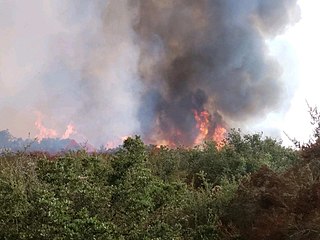
The Tenaja Fire was a wildfire in the rural community of La Cresta southwest of Murrieta in Riverside County, California, United States, located 80 miles from Los Angeles. The fire broke out on Wednesday, September 4, 2019 and ballooned to 1,926 acres (8 km2) over the course of two days. The blaze, dubbed the Tenaja fire after igniting along Tenaja Road and Clinton Keith Road in La Cresta, forced the evacuation of over 1,200 people and lead to the closure of multiple school districts in the Murrieta, Perris and Lake Elsinore area due to the poor air quality. The exact cause of the fire remains under investigation although several sources cited the possibility of lightning being the direct cause. Two structures were damaged as a result of the fire and one firefighter suffered minor injuries. The fire was contained on September 14 and had burned 1,926 acres (779 ha).
This page is based on this Wikipedia article Text is available under the CC BY-SA 4.0 license; additional terms may apply. Images, videos and audio are available under their respective licenses.