The Cahuilla, also known as ʔívil̃uqaletem or Ivilyuqaletem, are a Native American people of the inland areas of southern California. Their original territory included an area of about 2,400 square miles (6,200 km2). The traditional Cahuilla territory was near the geographic center of Southern California. It was bounded to the north by the San Bernardino Mountains, to the south by Borrego Springs and the Chocolate Mountains, to the east by the Colorado Desert, and to the west by the San Jacinto Plain and the eastern slopes of the Palomar Mountains.

The Cahuilla Band of Cahuilla Indians of the Cahuilla Reservation is a federally recognized tribe of Native American Indians, who are located in California. Their tribe originally came from Coachella Valley, through San Gorgonio Pass, to the San Jacinto Mountains. In 1875, their tribe had been relocated to modern day Anza.
The Agua Caliente Band of Cahuilla Indians of the Agua Caliente Indian Reservation is a federally recognized tribe of the Cahuilla, located in Riverside County, California. They inhabited the Coachella Valley desert and surrounding mountains between 5000 BCE and 500 AD. With the establishment of the reservations, the Cahuilla were officially divided into 10 sovereign nations, including the Agua Caliente Band.

Anza is a census-designated place located in southern Riverside County, California, in the Anza Valley, a semi-arid region at a mean elevation of 3,921 feet (1,195 m) above sea level. It is located 13 miles (21 km) south of Idyllwild, 32 miles (51 km) east of Temecula, 40 miles (64 km) southwest of Palm Springs, and 90 miles (140 km) northeast of San Diego, being traversed by State Route 371. The population was 3,014 at the 2010 census.

Mission Indians are the indigenous peoples of California who lived in Southern California and were forcibly relocated from their traditional dwellings, villages, and homelands to live and work at 15 Franciscan missions in Southern California, and the Asisténcias and Estáncias established between 1796 and 1823 in the Las Californias Province of the Viceroyalty of New Spain.
Cahuilla traditional narratives include myths, legends, tales, and oral histories preserved by the Cahuilla people of the Colorado Desert and Peninsular Ranges of southern California.

The Augustine Band of Cahuilla Indians is a federally recognized Cahuilla band of Native Americans based in Coachella, California. They are one of the smallest tribal nation in the United States, consisting of only eight members, only one of whom is an adult. As of the 2010 census, the tribe had expanded its members to eleven.
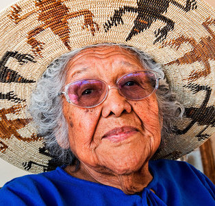
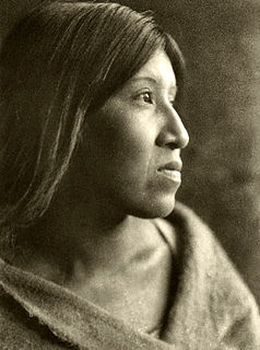
Katherine Siva Saubel was a Native American scholar, educator, tribal leader, author, and activist committed to preserving her Cahuilla history, culture and language. Her efforts focused on preserving the language of the Cahuilla. Saubel is acknowledged nationally and internationally as one of California's most respected Native American leaders. She received an honorary PhD in philosophy from La Sierra University, Riverside, California, and was awarded the Chancellor's Medal, the highest honor bestowed by the University of California at the University of California, Riverside.
The California Inland Empire Council (CIEC) of the Boy Scouts of America was formed in 1973 through the merger of the Arrowhead Area (#048) and Riverside Area Councils (#045). In 1974 Grayback Council (#024) also merged into the new council. In 2006, the council acquired the San Bernardino County portions of Old Baldy Council (#043). The council territory includes all of Riverside and San Bernardino Counties.

San Timoteo Canyon is a river valley canyon northeast of Redlands, in the far northwestern foothills of the San Jacinto Mountains in the Inland Empire region of Southern California.
The Hardy River is a 26-kilometer (16 mi)-long Mexican river formed by residual agricultural waters from the Mexicali Valley and running into the Colorado River. The river is believed to have been an ancient channel of the Colorado. In the 19th century, an Englishman lieutenant named R.W.H.Hardy explored the Colorado River Delta, and noted that the main channel of the Colorado followed this course. Later in the 1880s, sea captains noted that the main channel of the Colorado had moved east, and this old channel became known as Hardy's Colorado.

Ivilyuat, is an endangered Uto-Aztecan language, spoken by the various tribes of the Cahuilla Nation, living in the Coachella Valley, San Gorgonio Pass and San Jacinto Mountains region of Southern California. Cahuilla call themselves ʔívil̃uwenetem or Iviatam–speakers of Ivilyuat (Ivi'a)–or táxliswet meaning "person." A 1990 census revealed 35 speakers in an ethnic population of 800. With such a decline, Ivilyuat is classified as "critically endangered" by the UNESCO Atlas of the World's Languages in Danger as most speakers are middle-aged or older with limited transmission rates to children.
The Ramona Band of Cahuilla is a federally recognized tribe of Cahuilla Indians, located in Riverside County, California.
The Cabazon Band of Mission Indians is a federally recognized tribe of Cahuilla Indians, located in Riverside County, California.
The Santa Rosa Band of Cahuilla Indians is a federally recognized tribe of Cahuilla Indians, located in Riverside County, California.
The Torres-Martinez Desert Cahuilla Indians is a federally recognized tribe of Cahuilla and Chemehuevi Indians, located in Imperial and Riverside counties in California. Their autonym is Mau-Wal-Mah Su-Kutt Menyil, which is said to mean "among the palms, deer moon."
Los Coyotes Band of Cahuilla and Cupeño Indians of the Los Coyotes Reservation is a federally recognized tribe of Cahuilla and Cupeño Indians, who are Mission Indians located in California.

The Morongo Band of Mission Indians is a federally recognized tribe. The main tribal groups are Cahuilla and Serrano. Tribal members also include Cupeño, Luiseño, and Chemehuevi Indians. Although many tribes in California are known as Mission Indians, some, like those at Morongo, were never a part of the Spanish Missions in California. The Morongo Reservation is located in Riverside County, California.

Cahuilla is an unincorporated community in Riverside County, California. It lies at an elevation of 3642 feet. Cahuilla is located 14 miles (22.5 km) south of Idyllwild.

Lake Cahuilla was a prehistoric lake in California and northern Mexico. Located in the Coachella and Imperial Valleys, it covered surface areas of 5,700 square kilometres (2,200 sq mi) to a height of 12 metres (39 ft) above sea level during the Holocene. During earlier stages of the Pleistocene, the lake reached even higher levels, up to 31–52 metres (102–171 ft) above sea level. During the Holocene most of the water came from the Colorado River with little contribution from local runoff; in the Pleistocene local runoff was higher and it is possible that Lake Cahuilla was supported solely from local water sources during the Wisconsin glaciation. The lake overflowed close to Cerro Prieto into the Rio Hardy, eventually draining into the Gulf of California.


