Lost Lake Resort, California

Last updated
Lost Lake
USA California location map.svg
Red pog.svg
Lost Lake
Location within the state of California
Coordinates: 34°00′44″N114°28′27″W / 34.01222°N 114.47417°W / 34.01222; -114.47417 Coordinates: 34°00′44″N114°28′27″W / 34.01222°N 114.47417°W / 34.01222; -114.47417
Country United States
State California
County Riverside
Elevation
318 ft (97 m)
Time zone UTC-8 (Pacific (PST))
  Summer (DST) UTC-7 (PDT)
ZIP codes
92225
Area code(s) 760/442
GNIS feature ID 245216 [1]
Website http://www.lostlakeriverresort.com/

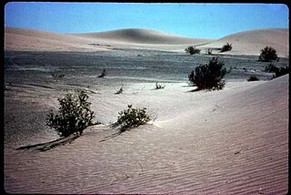
Lost Lake (also known as Lost Lake Resort and Lost Lake Landing) is a desert community located along the west shore of the Colorado River. It also lies along U.S. Route 95 near the northeastern extent of Riverside County. Official U.S. Geological Survey feature ID is 245216 and NAD27 coordinates for the community are 34°00′44″N114°28′27″W / 34.01222°N 114.47417°W / 34.01222; -114.47417 . The community lies at the foot of Riverside Mountain, 34°00′49″N114°30′45″W / 34.01361°N 114.51250°W / 34.01361; -114.51250 (Riverside Mountain) , with a summit measuring 2,127 feet. The community is named for a lake, Lost Lake, located at 34°01′20″N114°28′21″W / 34.02222°N 114.47250°W / 34.02222; -114.47250 (Lost Lake) .

Unincorporated area Region of land not governed by own local government

In law, an unincorporated area is a region of land that is not governed by a local municipal corporation; similarly an unincorporated community is a settlement that is not governed by its own local municipal corporation, but rather is administered as part of larger administrative divisions, such as a township, parish, borough, county, city, canton, state, province or country. Occasionally, municipalities dissolve or disincorporate, which may happen if they become fiscally insolvent, and services become the responsibility of a higher administration. Widespread unincorporated communities and areas are a distinguishing feature of the United States and Canada. In most other countries of the world, there are either no unincorporated areas at all, or these are very rare; typically remote, outlying, sparsely populated or uninhabited areas.

Colorado River major river in the western United States and Mexico

The Colorado River is one of the principal rivers in the Southwestern United States and northern Mexico. The 1,450-mile-long (2,330 km) river drains an expansive, arid watershed that encompasses parts of seven U.S. and two Mexican states. Starting in the central Rocky Mountains of Colorado, the river flows generally southwest across the Colorado Plateau and through the Grand Canyon before reaching Lake Mead on the Arizona–Nevada border, where it turns south toward the international border. After entering Mexico, the Colorado approaches the mostly dry Colorado River Delta at the tip of the Gulf of California between Baja California and Sonora.

U.S. Route 95 highway in the United States

U.S. Route 95 (US 95) is a north–south U.S. highway in the western United States. Unlike many other US highways, it has not seen deletion or replacement on most of its length by an encroaching Interstate highway corridor, due to its mostly rural course. Because of this, it still travels from border to border and is a primary north–south highway in both Nevada and Idaho. This is one of the only US Routes or Interstate highways to cross from Mexico to Canada.

Contents

The area has been assigned to part of the 92225 ZIP Code, which it shares with Blythe. The Census Bureau designates this area as rural. The area is part of the Lost Lake Directory Area in area code 760 and is included in the Mojave Desert Air Quality Management District.

Blythe, California City in California, United States

Blythe is a city in Riverside County, California, United States, in the Palo Verde Valley of the Lower Colorado River Valley region, an agricultural area and part of the Colorado Desert along the Colorado River, approximately 224 miles (360 km) east of Los Angeles and 150 miles (240 km) west of Phoenix. Blythe was named after Thomas H. Blythe, a San Francisco financier, who established primary water rights to the Colorado River in the region in 1877. The city was incorporated on July 21, 1916. The population was 20,817 at the 2010 census.

Area codes 760 and 442 Area codes for southern and eastern California

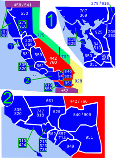
Area code 760 is a California telephone area code that was split from area code 619 on March 22, 1997. Area code 442 is an overlay of 760 that became effective on November 21, 2009. It encompasses much of the southeastern and southernmost portions of California. The area includes Imperial, Inyo, and Mono counties, as well as portions of San Diego, Riverside, San Bernardino, Los Angeles and Kern counties.

The State Department of Fish and Game has been studying elf owl populations in the area.

Elf owl species of bird

The elf owl is a member of the owl family Strigidae, that breeds in the southwestern United States and Mexico. It is the world's lightest owl, although the long-whiskered owlet and the Tamaulipas pygmy owl are of a similarly diminutive length. It is also the world's smallest owl. The mean body weight of this species is 40 g (1.4 oz). These tiny owls are 12.5 to 14.5 cm long and have a wingspan of about 27 cm (10.5 in). Their primary projection extends nearly past their tail. They have fairly long legs and often appear bow-legged. They can often be heard calling to one another just after dusk or at sunset. Their call is a high-pitched whinny or chuckle. The male and female dart around trees and call back and forth.

This community is part of the Colorado River Indian Reservation (USGS feature 22753). The reservation was established on March 3, 1865. According to the National Geographic Names Database, residents are primarily Hualapai, Yavapai, Navajo, and Hopi.

Lost Lake Resort

Lost Lake Resort is a boating and camping community located along the Colorado River. The resort is described on their website as "A river front community and vacation resort on the Colorado River located just 31 miles north of Blythe CA on Hwy 95. Lost Lake River Resort is a popular destination for all water sport recreation. Everything from boating, wakeboarding, jet skiing, fishing, tubing, to water skiing." [2]

Local services are a gas station, convenience store, fire station, church, and recreational center.

See also

Parker, Arizona Town in Arizona, United States

Parker is the county seat of La Paz County, Arizona, United States, on the Colorado River in Parker Valley. The population was 3,083 at the 2010 census.

Poston, Arizona Census-designated place in Arizona, United States

Poston is an unincorporated community and census-designated place (CDP) in La Paz County, Arizona, United States, in the Parker Valley. The population was 285 at the 2010 census, down from 389 at the 2000 census.

Vidal, California Unincorporated community in California, United States

Vidal, California is a small unincorporated community located in southeastern California, in San Bernardino County on U.S. Route 95, 38 miles (61 km) north of Blythe, California, United States and 55 miles (89 km) south of Needles. The town is 22 miles (35 km) west of the townsite of Earp, California and 23 miles (37 km) west of Parker, Arizona on State Highway 62. The community, which is two miles (3 km) north of the Riverside County line, lies at an elevation of 812 feet (247 m) above sea level. Vidal is 221 miles (356 km) from the city of San Bernardino, making it the second-farthest town in the county from the county seat behind Earp. Wyatt Earp spent the last winters of his life in Vidal, working claims of gold and copper he found nearby; the aforementioned townsite of Earp is located in and around those claims.

Sources

Related Research Articles

Fort Mojave Indian Reservation Indian reservation in United States, Fort Mojave

The Fort Mohave Indian Reservation is an Indian reservation along the Colorado River, currently encompassing 23,669 acres (95.79 km2) in Arizona, 12,633 acres (51.12 km2) in California, and 5,582 acres (22.59 km2) in Nevada. Originally established in 1870, the reservation is home to approximately 1,100 members of the federally recognized Fort Mojave Indian Tribe of Arizona, California, and Nevada, a federally recognized tribe of Mohave people.

Salton Sea State Recreation Area protected area in California

Located on the northeastern side of the Salton Sea, the Salton Sea State Recreation Area offers hunting, fishing, swimming, and camping to visitors.

Cherry Run river in the United States of America

Cherry Run is a 7.2-mile-long (11.6 km) meandering stream that forms the northern section of the boundary between Morgan and Berkeley counties in West Virginia's Eastern Panhandle. While it is mostly non-navigable, Cherry Run provides many pools of varying depths for fishing and swimming. As a tributary of the Potomac River, Cherry Run is part of the Potomac and Chesapeake Bay watersheds.

Colorado River Indian Tribes federally recognized tribe

The Colorado River Indian Tribes is a federally recognized tribe consisting of the four distinct ethnic groups associated with the Colorado River Indian Reservation: Chemehuevi, the Mohave, Hopi, and Navajo. The tribe has about 4,277 enrolled members. A total population of 9,485 currently resides within the tribal reservation according to the 2012-2016 American Community Survey data.

Ochlockonee, Florida human settlement in Florida, United States of America

Ochlockoneee is an unincorporated community in western Leon County, Florida, United States, located at U.S. Route 90 and County Road 260 and at the Ochlockonee River, west of Tallahassee by three miles (4.8 km).

Ripley, California census-designated place in California, United States

Ripley is a census-designated place community in east Riverside County. It is located along State Route 78 (SR78) between Palo Verde and Blythe. The area is mostly agricultural lands irrigated by Colorado River water. The elevation is 249 feet (76 m). The population was 692 at the 2010 census.

River Bend Lodge, California Unincorporated community in California, United States

River Bend Lodge is an unincorporated community in Riverside County, California, also known as Aha Quin. The community is near Hall Island along the Colorado River and hosts Riverside County Fire Department, Station 46. River Bend Lodge is also inside the Mojave Desert Air Quality Management District.

Catfish Paradise is an unincorporated community in Mohave County, Arizona, in the United States. It is located at the southern end of the Topock Marsh along the Colorado River.

Riverside is an unincorporated community in Ravalli County, Montana, United States. Its elevation is 3,517 feet (1,072 m), and it is located at 46°16′29″N114°9′29″W.

Lava Beds, California Former settlement in California, United States

Lava Beds is a former settlement in Butte County, California. It lay at an elevation of 151 feet. It remained on maps as late as 1895. It was a community of Chinese miners, located near Pacific Heights, 2.5 miles (4.0 km) north-northwest of Palermo.

Potholes is a former gold camp and settlement in Imperial County, California. The settlement was located on the railroad line 4 miles (6.4 km) northeast of Bard along the Colorado River near the site of the Laguna Dam.

Aubrey Landing, Arizona Ghost town in Arizona, United States

Aubrey Landing, Aubrey City or Aubrey is a ghost town at the mouth of the Bill Williams River in southern Mohave County, Arizona. The town was founded before 1865 and was abandoned sometime after 1886. Aubrey Landing was inundated when Lake Havasu was formed.

Palo Verde Valley valley in California, United States of America

The Palo Verde Valley is located in the Lower Colorado River Valley, next to the eastern border of Southern California with Arizona, United States. It is located on the Colorado Desert within the Sonoran Desert south of the Parker Valley. Most of the valley is in Riverside County, with the southern remainder in Imperial County. La Paz County borders to the east on the Colorado River.

Rice Valley Wilderness

The Rice Valley Wilderness is a wilderness area near Blythe and Rice in the Mojave Desert region of California, managed by the Bureau of Land Management.

Liverpool Landing, a ghost town and former river settlement on the Colorado River, in Mohave County, Arizona, now under Lake Havasu.

Hualapai Valley is a valley in Mohave County, Arizona.

The Needles (Arizona) rock formation in the Havasu National Wildlife Refuge in Mohave County, Arizona, United States

The Needles are a distinctive group of rock pinnacles, mountain peaks adjacent to the Topock Gorge, and the Colorado River on the northwestern extreme of the Mohave Mountains within the Havasu National Wildlife Refuge in Mohave County, Arizona, United States. They range from 1207 to over 1600 feet in altitude.

New Harmony is an unincorporated community in Brown County, in the U.S. state of Ohio.

Deer Island is an island in the Colorado River, divided between La Paz County in the U.S. state of Arizona and San Bernardino County in the U.S. state of California.

References

  1. "Lost Lake Resort, California". Geographic Names Information System . United States Geological Survey.
  2. "Archived copy". Archived from the original on 2013-01-28. Retrieved 2012-09-06.CS1 maint: archived copy as title (link)