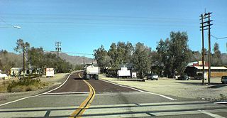
Nipton is an unincorporated community in the Ivanpah Valley in San Bernardino County, California. With a population of about 15 – 20, it is located on the northeastern border of Mojave National Preserve, approximately 12 miles (19 km) southeast of Primm, Nevada and the Ivanpah Solar Power Facility. It is accessible via Nevada State Route 164.

Tehachapi Pass is a mountain pass crossing the Tehachapi Mountains in Kern County, California. Traditionally, the pass marks the northeast end of the Tehachapis and the south end of the Sierra Nevada range.

A horseshoe curve is a class of climbing curve in a roadbed which reverses turn direction (inflection) twice on either side of a single tight curve that varies through an angle of about 180 degrees or more.
The Kansas Pacific Railway (KP) was a historic railroad company that operated in the western United States in the late 19th century. It was a federally chartered railroad, backed with government land grants. At a time when the first transcontinental railroad was being constructed by the Central Pacific and the Union Pacific, it tried and failed to join the transcontinental ranks. It was originally the "Union Pacific, Eastern Division", although it was completely independent. The Pennsylvania Railroad, working with Missouri financiers, designed it as a feeder line to the transcontinental system. The owners lobbied heavily in Washington for money to build a railroad from Kansas City to Colorado, and then to California. It failed to get funding to go west of Colorado. It operated many of the first long-distance lines in the state of Kansas in the 1870s, extending the national railway network westward across that state and into Colorado. Its main line furnished a principal transportation route that opened up settlement of the central Great Plains, and its link from Kansas City to Denver provided the last link in the coast-to-coast railway network in 1870. The railroad was consolidated with the Union Pacific in 1880, and its mainline continues to be an integral part of the Union Pacific network today.

Daggett is an unincorporated community located in San Bernardino County, California in the United States. The town is located on Interstate 40 ten miles (16 km) east of Barstow. The town has a population of about 200. The ZIP code is 92327 and the community is inside area code 760.

The California Northern Railroad is one of several Class III short-line railroad companies owned by Genesee & Wyoming, Inc. It operates over Southern Pacific Railroad (SP) tracks under a long-term lease.
Cima is a small unincorporated community in the Mojave Desert of San Bernardino County, California, in the United States. It lies in a mountain pass on the divide between the Ivanpah Valley and the Mojave River basin, at an elevation of 4,175 feet (1,273 m). The Ivanpah Mountains and Interstate 15 are to the north, the New York Mountains are to the east, and the Providence Mountains are to the south. To the northwest is the Cima volcanic field, which contains Cima Dome at 5,745 feet (1,751 m) above sea level, a prominent landmark along I-15. Cima is also home to one of the densest Yucca brevifolia forests in California, located in the Cima Dome.

The Santa Fe, Prescott and Phoenix Railway (SFP&P) was a common carrier railroad that later became an operating subsidiary of the Atchison, Topeka and Santa Fe Railway in Arizona. At Ash Fork, Arizona, the SFP&P connected with Santa Fe's operating subsidiary, the Atlantic & Pacific Railroad mainline, that ran from California to Chicago. The SFP&P's 195-mile (314 km) line extended the Santa Fe Railway south into Phoenix. The SFP&P extended another 100 miles (160 km) to the east from Phoenix to Florence and Winkelman via the Phoenix and Eastern Railroad. The SFP&P also served several mines in the Prescott area through its various subsidiary railroads.

Laws is an unincorporated community in Inyo County, California. Laws is located 4 miles (6.4 km) northeast of Bishop on U.S. Route 6, towards the Nevada state line.

The South Pacific Coast Railroad (SPC) was a 3 ft narrow gauge steam railroad running between Santa Cruz, California and Alameda, with a ferry connection in Alameda to San Francisco. The railroad was created as the Santa Clara Valley Railroad, founded by local strawberry growers as a way to get their crops to market in San Francisco and provide an alternative to the Southern Pacific Railroad. In 1876, James Graham Fair, a Comstock Lode silver baron, bought the line and extended it into the Santa Cruz Mountains to capture the significant lumber traffic coming out of the redwood forests. The narrow-gauge line was originally laid with 52-pound-per-yard (26 kg/m) rail on 8-foot (2.44 m) redwood ties; and was later acquired by the Southern Pacific and converted to 4 ft 8 1⁄2 instandard gauge.

There are several solar power plants in the Mojave Desert which supply power to the electricity grid. Insolation in the Mojave Desert is among the best available in the United States, and some significant population centers are located in the area. These plants can generally be built in a few years because solar plants are built almost entirely with modular, readily available materials. Solar Energy Generating Systems (SEGS) is the name given to nine solar power plants in the Mojave Desert which were built in the 1980s, the first commercial solar plant. These plants have a combined capacity of 354 megawatts (MW) which made them the largest solar power installation in the world, until Ivanpah Solar Power Facility was finished in 2014.
Path 46, also called West of Colorado River, Arizona-California West-of-the-River Path (WOR), is a set of fourteen high voltage alternating-current transmission lines that are located in southeast California and Nevada up to the Colorado River.
Huntingdon is a community within Abbotsford, British Columbia, Canada. It is located immediately north of the Canada–US border, and is the location of the Sumas-Huntingdon Border Crossing. The main road through the community is Highway 11. The name of the community is also the present name of the border crossing connecting to Sumas, Washington.
Rail transportation is an important element of the transportation network in the U.S. state of Oregon. Rail transportation has existed in Oregon in some form since 1855, and the state was a pioneer in development of electric railway systems. While the automobile has displaced many uses of rail in the state, rail remains a key means of moving passengers and freight, both within the state and to points beyond its borders.

The Ivanpah Solar Electric Generating System is a concentrated solar thermal plant in the Mojave Desert. It is located at the base of Clark Mountain in California, across the state line from Primm, Nevada. The plant has a gross capacity of 392 megawatts (MW). It deploys 173,500 heliostats, each with two mirrors focusing solar energy on boilers located on three 459 ft tall solar power towers. The first unit of the system was connected to the electrical grid in September 2013 for an initial synchronisation test. The facility formally opened on February 13, 2014. In 2014, it was the world's largest solar thermal power station.

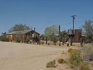
Barnwell, originally a rail camp named Summit, then Manvel, was a former railhead serving local mining camps, now a ghost town, in San Bernardino County, California. It lies at an elevation 4806 feet in the New York Mountains.

California Eastern Railway, is a defunct 45-mile (72 km) short-line railroad that operated from 1902 - 1911. The railroad ran from Goffs, California, to Ivanpah. It was first a private line operated by a mining company, that was acquired by the Atchison, Topeka and Santa Fe Railway.
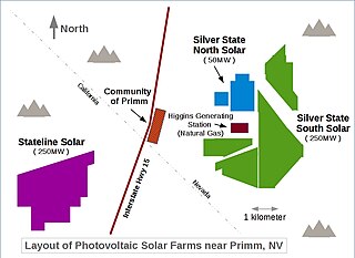
Desert Stateline Solar Facility is a 300 MWp utility-scale solar photovoltaic power station constructed by First Solar in San Bernardino County California. It is located at the base of Clark Mountain in California, across the state line from Primm, Nevada and adjacent to the Ivanpah Solar Power Facility.


