Eldora, previously known as "Eldorado" then "El-Dora", then Eldora or Camp Eldorado, and still called Happy Valley, is an unincorporated community and a census-designated place (CDP) located in and governed by Boulder County, Colorado, United States. The CDP is a part of the Boulder, CO Metropolitan Statistical Area. The population of the Eldora CDP was 140 at the United States Census 2020. The Nederland post office serves the area.

Calico is a ghost town and former mining town in San Bernardino County, California, United States. Located in the Calico Mountains of the Mojave Desert region of Southern California, it was founded in 1881 as a silver mining town, and was later converted into a county park named Calico Ghost Town. Located off Interstate 15, it lies 3 miles (4.8 km) from Barstow and 3 miles from Yermo. Giant letters spelling CALICO are visible, from the highway, on the Calico Peaks behind it. Walter Knott purchased Calico in the 1950s, and rebuilt all but the five remaining original buildings to look as they did in the 1880s. Calico received California Historical Landmark #782, and in 2005 was proclaimed by then-Governor Arnold Schwarzenegger to be California's Silver Rush Ghost Town.

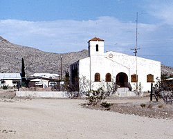
Kelso is a ghost town and defunct railroad depot in the Mojave National Preserve in San Bernardino County, California, USA. It was named after railroad worker John H. Kelso, whose name was placed into a hat along with two other workers to decide the name of the town. The town was built in 1905 specifically as a railroad station along the rail line between Utah and Los Angeles, originally called "Siding 16," because of its location and nearby springs that provided abundant water. Historic Spots in California states, "At Kelso stands a beautiful Spanish-style Union Pacific Depot built about 1906, surrounded by shade trees, a welcome rarity in the hot, barren desert."

Cherokee is an unincorporated community and census-designated place in Butte County, California. It is an area inhabited by Maidu Indians prior to the gold rush, but that takes its name from a band of Cherokee prospectors who perfected a mining claim on the site. The population was 69 at the 2010 census. It lies at an elevation of 1306 feet.

Yermo is an unincorporated community and census-designated place (CDP) in the Mojave Desert in San Bernardino County, California. It is 13 miles (21 km) east of Barstow on Interstate 15, just south of the Calico Mountains. Its population was estimated at 1,750 in 2009.

Caliente is an unincorporated community in Kern County, California. It is located 22 miles (35 km) east-southeast of Bakersfield, at an elevation of 1,312 feet (400 m).

New Idria was an unincorporated town in San Benito County, California. It was named after the New Idria Mercury Mine, which closed in 1972, resulting in a ghost town.
Oro Grande is an unincorporated community in the Mojave Desert of San Bernardino County, California, United States. It lies on the city boundary of Victorville and Adelanto. It is at 3,000 feet (910 m) elevation in Victor Valley north of the San Bernardino mountain range. It is located on old Route 66 near Interstate 15 between Victorville and Barstow. The ZIP code is 92368 and the community is inside area codes 442 and 760. Less than 1,000 residents live in the unincorporated area.

Tuscarora is an unincorporated community in Elko County, Nevada, United States. The community lies on the east side of the Tuscarora Mountains approximately 40 miles north of Carlin. Tuscarora is part of the Elko Micropolitan Statistical Area. Far from being a ghost town, as several websites proclaim, Tuscarora is home to two schools, a library, a post office and a bar and grill, as well as homes for its remaining residents.
Sheep Ranch is an unincorporated community in Calaveras County, California. It lies at an elevation of 2359 feet.

Havilah was an unincorporated community in Kern County, California that was completely leveled by the 2024 Borel Fire. The land is located in the mountains between Walker Basin and the Kern River Valley, 5 miles (8.0 km) south-southwest of Bodfish at an elevation of 3,136 feet (956 m).

Earp, California is an unincorporated community in San Bernardino County in the Sonoran Desert close to the California/Arizona state line at the Colorado River in Parker Valley.

Gold Run was a former mining town of the California Gold Rush, located in Placer County, California.
Belleville, California was a gold mining boomtown in the San Bernardino Mountains of San Bernardino County, California. The settlement grew up rapidly following the discovery of gold by William F. Holcomb in Holcomb Valley early 1860. Which helped the town challenge the seat of San Bernardino County. Belleville was named after Belle, the first child born in the new town. It was a busy mining town for ten years, it was virtually abandoned before the end of the 19th century. It is now a ghost town.

Forest Falls is an unincorporated community in San Bernardino County, California, 75 miles (121 km) due east of Los Angeles. The community has a population of 1,102 and contains 712 houses. Forest Falls is best known for the waterfalls on Vivian and Falls creeks and as a point of access for recreation in the San Bernardino National Forest, particularly the San Gorgonio Wilderness Area, which lies directly north of the community.
Rimforest is an unincorporated community in the San Bernardino Mountains of San Bernardino County, California, United States. It is located along California State Route 18. Rimforest has a post office with ZIP code 92378, which opened in 1949. Rimforest was featured in a season 5 episode of Storage Wars.
Cedarpines Park is an unincorporated community in San Bernardino County, California, United States. Cedarpines Park is 10 miles (16 km) north-northwest of San Bernardino. Cedarpines Park has a post office with ZIP code 92322. The post office opened in 1927 and was closed from 1943 to 1946.
Crest Park is an unincorporated community in San Bernardino County, California, United States. Crest Park is located in the San Bernardino Mountains on California State Route 18 1 mile (1.6 km) south of Lake Arrowhead. Crest Park had a post office with ZIP code 92326, which opened in 1949.

Skyforest is an unincorporated community in San Bernardino County, California, United States.
Twin Peaks is an unincorporated community in San Bernardino County, California, United States within the heart of the San Bernardino Mountains. California State Route 189 runs through the entire area before it reaches Lake Arrowhead. Twin Peaks has a post office with ZIP code 92391, which opened in 1916.