Grand Terrace, California

Last updated

Grand Terrace, California
Views of Grand Terrace, CA.png
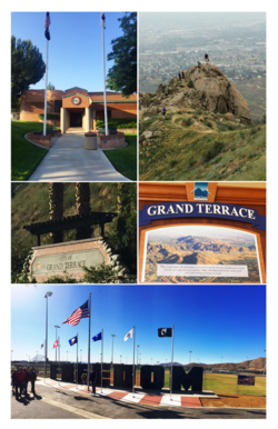
City of Grand Terrace images from top, left to right - Grand Terrace City Hall, Blue Mountain Trail, Northeast City Entrance, Historical Plaque, Veterans Wall of Freedom
Seal of Grand Terrace, California.png
San Bernardino County California Incorporated and Unincorporated areas Grand Terrace Highlighted 0630658.svg
Location of Grand Terrace in San Bernardino County, California.
Usa edcp relief location map.png
Red pog.svg
Grand Terrace, California
Location in the United States
Coordinates: 34°02′02″N117°18′49″W / 34.03389°N 117.31361°W / 34.03389; -117.31361 [1]
Country Flag of the United States.svg United States
State Flag of California.svg  California
County Flag of San Bernardino County, California.svg San Bernardino
Incorporated November 30, 1978 [2]
Government
  Type Council-manager [3]
   Mayor Darcy McNaboe [4]
   City Manager G. Harold Duffey [3]
Area
[5]
  Total3.50 sq mi (9.08 km2)
  Land3.50 sq mi (9.08 km2)
  Water0.00 sq mi (0.00 km2)  0%
Elevation
[1]
1,063 ft (324 m)
Population
 (2020) [6]
  Total13,150
  Density3,590.30/sq mi (1,386.33/km2)
Time zone UTC-8 (PST)
  Summer (DST) UTC-7 (PDT)
ZIP code
92313
Area code 909
FIPS code 06-30658
GNIS feature ID 1660692
Website www.grandterrace-ca.gov

Grand Terrace is a city in San Bernardino County, California, United States. The population was 12,040 at the 2010 census, up from 11,626 at the 2000 census. Grand Terrace is located between Highgrove and Colton, along the I-215 and Agua Mansa industrial corridors. The city is located between two mountain ridges: Blue Mountain to the east and the La Loma Hills to the west.

Contents

History

Grand Terrace's roots go back to Mexican land grants dating from the period between 1830 and 1840. Mormon settlers came shortly after, arriving in the San Bernardino Valley, during the 1850s. [7] According to the Riverside Press, in 1876, there were nine buildings in the Terrace-Colton area. Originally, the area was simply referred to as "the Terrace", but the word "Grand" was added around 1898 due to the beautiful views which surround the city. In 1905, Seventh-day Adventists, whose medical university is now located in nearby Loma Linda, [8] settled in the area. Grand Terrace, at the time known as "South Colton", experienced continued growth and development during the Southern California suburbia and sunbelt periods in the late half of the 20th century.

The development of Grand Terrace, or East Riverside, as the Grand Terrace-Highgrove area was called, became a reality with the construction of the Gage Canal. This 22-1/2-mile canal, built at a cost of 2 million dollars, brought water from the Santa Ana River marshlands below The Terrace. With plenty of irrigation water, Grand Terrace rapidly became an agricultural community featuring fine, quality citrus. The severe "freeze" of 1913 destroyed many groves. Walnuts, a hardier tree, were planted as replacements along with peaches as a quick-profit crop.

The social activities in the early 1900s centered around the Farm Bureau Extension Service and the Women's Club, followed by the PTA, in the 1930s. Since there were no local churches, people traveled to surrounding communities for worship and other church activities.

In 1962, the Grand Terrace Chamber of Commerce was organized. From the very beginning the Chamber was interested in preserving the local identity of the area, and therefore, was a strong supporter of cityhood. This group did much of the groundwork, which led to the formation of a local governing body in 1976, which was called the Municipal Advisory Council or MAC. After nearly two years of meetings and negotiations with the county, the residents went to the polls to decide the issue of cityhood. The response was an 82% vote for incorporation. On November 30, 1978, the Charter City Council was installed at Terrace Hills Junior High and Grand Terrace officially became the 16th city in San Bernardino County. [9]

Grand Terrace was named one of the "Top 100 Cities to Live In" by Money magazine in 2007. [10]

Geography

Blue Mountain in Grand Terrace, CA. Blue Mountain CA.jpg
Blue Mountain in Grand Terrace, CA.

This 3.6-square-mile (9.3 km2) community has an average elevation of 1,065 feet (325 m). Its motto, inscribed on the city flag, is "The Blue Mountain City" (its official slogan is "A city set upon a mountain cannot be hidden"), and refers to the Blue Lupine flower that used to grow on Blue Mountain in the spring.

According to the United States Census Bureau, the city has a total area of 3.5 square miles (9.1 km2), all land.

Demographics

Historical population
CensusPop.Note
1970 5,901
1980 8,49844.0%
1990 10,94628.8%
2000 11,6266.2%
2010 12,0403.6%
2019 (est.)12,584 [11] 4.5%
U.S. Decennial Census [12]

2010

The 2010 United States Census [13] reported that Grand Terrace had a population of 12,040. The population density was 3,438.0 inhabitants per square mile (1,327.4/km2). The racial makeup of Grand Terrace was 7,912 (65.7%) White (46.4% Non-Hispanic White), [14] 673 (5.6%) African American, 120 (1.0%) Native American, 778 (6.5%) Asian, 32 (0.3%) Pacific Islander, 1,898 (15.8%) from other races, and 627 (5.2%) from two or more races. Hispanic or Latino of any race were 4,708 persons (39.1%).

The census reported that 11,927 people (99.1% of the population) lived in households, 50 (0.4%) lived in non-institutionalized group quarters, and 63 (0.5%) were institutionalized.

There were 4,403 households, of which 1,548 (35.2%) had children under the age of 18 living in them, 2,214 (50.3%) were opposite-sex married couples living together, 599 (13.6%) had a female householder with no husband present, 254 (5.8%) had a male householder with no wife present. There were 285 (6.5%) unmarried opposite-sex partnerships, and 26 (0.6%) same-sex married couples or partnerships. 1,026 households (23.3%) were made up of individuals, and 395 (9.0%) had someone living alone who was 65 years of age or older. The average household size was 2.71. There were 3,067 families (69.7% of all households); the average family size was 3.20.

2,781 people (23.1% of the population) were under the age of 18, 1,244 people (10.3%) aged 18 to 24, 3,320 people (27.6%) aged 25 to 44, 3,195 people (26.5%) aged 45 to 64, and 1,500 people (12.5%) who were 65 years of age or older. The median age was 36.1 years. For every 100 females, there were 92.9 males. For every 100 females age 18 and over, there were 89.6 males.

There were 4,649 housing units at an average density of 1,327.5 per square mile (512.6/km2), of which 2,790 (63.4%) were owner-occupied, and 1,613 (36.6%) were occupied by renters. The homeowner vacancy rate was 1.7%; the rental vacancy rate was 7.0%. 7,848 people (65.2% of the population) lived in owner-occupied housing units and 4,079 people (33.9%) lived in rental housing units.

According to the 2010 United States Census, Grand Terrace had a median household income of $64,073, with 6.5% of the population living below the federal poverty line. [14]

2000

At the 2000 census, [15] there were 11,626 people, 4,221 households and 3,051 families residing in the city. The population density was 3,352.3 inhabitants per square mile (1,294.3/km2). There were 4,458 housing units at an average density of 1,285.4 per square mile (496.3/km2). The racial makeup of the city was 73.8% White, 4.6% African American, 0.7% Native American, 5.6% Asian, 0.3% Pacific Islander, 9.8% from other races, and 5.2% from two or more races. Hispanic or Latino of any race were 25.4% of the population.

There were 4,221 households, of which 35.0% had children under the age of 18 living with them, 54.1% were married couples living together, 13.5% had a female householder with no husband present, and 27.7% were non-families. 21.7% of all households were made up of individuals, and 5.6% had someone living alone who was 65 years of age or older. The average household size was 2.7 and the average family size was 3.6.

26.3% of the population were under the age of 18, 9.0% from 18 to 24, 31.2% from 25 to 44, 22.8% from 45 to 64, and 10.7% who were 65 years of age or older. The median age was 35 years. For every 100 females, there were 89.1 males. For every 100 females age 18 and over, there were 86.6 males.

The median household income was $53,649 and the median family income was $61,068. Males had a median income of $41,417 compared with $30,491 for females. The per capita income for the city was $21,787. About 4.5% of families and 7.4% of the population were below the poverty line, including 9.6% of those under age 18 and 4.5% of those age 65 or over.

Government

In the California State Legislature, Grand Terrace is in the 20th Senate District , represented by Democrat Caroline Menjivar, and in the 47th Assembly District , represented by Republican Greg Wallis. [16]

In the United States House of Representatives, Grand Terrace is in the 33rd Congressional District, represented by Peter Aguilar.

Currently the city council consists of Mayor Darcy McNaboe, Sylvia Robles, Douglas Wilson, William Hussey, and Jeff Allen. [4]

The City Manager is Konrad Bolowich. [17]

Public safety

The City of Grand Terrace contracts with the San Bernardino County Sheriff's Department. [18] The San Bernardino County Fire Department has a fire station on City Center Court. [19]

Education

The Colton Joint Unified School District serves the students of Grand Terrace with Grand Terrace Elementary School, Terrace View Elementary School, Terrace Hills Middle School, and Grand Terrace High School at the Ray Abril Jr. Educational Complex. The Roman Catholic Diocese of San Bernardino operates the Blessed Junipero Serra House of Formation in Grand Terrace. [20]

Notable Crime

Related Research Articles

<span class="mw-page-title-main">San Bernardino County, California</span> County in southern California, United States

San Bernardino County, officially the County of San Bernardino and sometimes abbreviated as S.B. County, is a county located in the southern portion of the U.S. state of California, and is located within the Inland Empire area. As of the 2020 U.S. Census, the population was 2,181,654, making it the fifth-most populous county in California and the 14th-most populous in the United States. The county seat is San Bernardino.

<span class="mw-page-title-main">Cherryland, California</span> Unincorporated Community in California, United States

Cherryland is an unincorporated community and census-designated place (CDP) in Alameda County, California, United States. Cherryland is located between Ashland to the north and the city of Hayward to the south. The population was 15,808 at the 2020 census.

<span class="mw-page-title-main">West Puente Valley, California</span> Census-designated place in California, United States

West Puente Valley is an unincorporated community and census-designated place in Los Angeles County, California, USA, northwest of La Puente. The population was 22,636 at the 2010 census, up from 22,589 at the 2000 census. The community is probably named for its location related to the city of La Puente.

<span class="mw-page-title-main">Highgrove, California</span> Census-designated place in California, United States

Highgrove is a census-designated place (CDP) and an unincorporated community in Riverside County, California, United States. The population was 3,988 at the 2010 census, up from 3,445 at the 2000 census. The latest 2020 census shows 7,515 total population, an 88.4% increase from last 2010 census, which makes it the fastest-growing location in entire Riverside County. The city of Riverside, California has plans to annex Highgrove in the near future.

<span class="mw-page-title-main">Mira Loma, California</span> Place in California, United States

Mira Loma, now officially part of Jurupa Valley, is a census-designated place (CDP) in Riverside County, California, United States. Its population was 21,930 in the 2010 census, up from 17,617 in the 2000 census.

<span class="mw-page-title-main">Big Bear City, California</span> Unincorporated community in California, United States

Big Bear City is an unincorporated community in San Bernardino County, California, United States along the east shore of Big Bear Lake and surrounded by the San Bernardino National Forest. It is 27 miles (43 km) northeast of the city of San Bernardino, and immediately east of the incorporated city of Big Bear Lake. For statistical purposes, the United States Census Bureau has defined Big Bear City as a census-designated place (CDP). Its population was 12,304 at the 2010 census, up from 5,779 at the 2000 census. Big Bear City is mostly residential, with smaller houses and cabins laid out in typical square block fashion. Big Bear is on the Pacific Crest Trail.

<span class="mw-page-title-main">Bloomington, California</span> Place in California, United States

Bloomington is an urban unincorporated community in San Bernardino County, California, United States. The population was 23,851 at the 2010 census, up from 19,318 at the 2000 census. For statistical purposes, the United States Census Bureau has defined Bloomington as a census-designated place (CDP).

<span class="mw-page-title-main">Chino, California</span> City in California, United States

Chino is a city in the western end of San Bernardino County, California, United States, with Los Angeles County to its west and Orange County to its south in the Southern California region.

<span class="mw-page-title-main">Colton, California</span> City in California, United States

Colton is a city in San Bernardino County, California, United States. Nicknamed "Hub City", Colton is located in the Inland Empire region of the state and is a suburb of San Bernardino, approximately 4 miles (6.4 km) south of the city's downtown. The population of Colton is 52,154 according to the 2010 census, up from 47,662 at the 2000 census.

<span class="mw-page-title-main">Highland, California</span> City in California, United States

Highland is a city in San Bernardino County, California, United States. The city's population was 56,999 at the 2020 census.

<span class="mw-page-title-main">Joshua Tree, California</span> Census-designated place in California, United States

Joshua Tree is a census-designated place (CDP) in San Bernardino County, California, United States. The population was 7,414 at the 2010 census. At approximately 2,700 feet above sea level, Joshua Tree and its surrounding communities are located in the High Desert of California. The center of the business district in Joshua Tree is on California State Route 62.

<span class="mw-page-title-main">Mentone, California</span> Census-designated place in California, United States

Mentone is a census-designated place in San Bernardino County, California, United States. The population was 7,803 at the 2000 census and 8,720 at the 2010 census. It is located at 34°3′53″N117°7′13″W.

<span class="mw-page-title-main">Montclair, California</span> City in California, United States

Montclair is a city in the Pomona Valley, in southwestern San Bernardino County, California, 35 miles (56 km) east of downtown Los Angeles. The population was 37,865 in the 2020 United States Census.

<span class="mw-page-title-main">Muscoy, California</span> Census-designated place in California, United States

Muscoy is a census-designated place (CDP) in San Bernardino County, California, United States. The population was 10,644 at the 2010 census, up from 8,919 at the 2000 census. Muscoy shares ZIP code 92407 with the communities of Verdemont, Devore Heights, Rosena Ranch and Arrowhead Farms in northwestern San Bernardino. Residents enjoy a semi-rural setting with large lots where they can raise horses and other livestock, nursery plants, and fruit trees. For this reason, much of Muscoy is included in the county Additional Agriculture (AA) overlay, which specifies the types and quantities of animals that may be kept on each parcel. A distinctive feature of Muscoy life today is motor vehicles and equestrians sharing the roadways.

<span class="mw-page-title-main">Running Springs, California</span> Census-designated place in California, United States

Running Springs is a census-designated place (CDP) in San Bernardino County, California, United States. The population was 5,268 at the 2020 census, up from 4,862 at the 2010 census. Running Springs is situated 17 miles west of the city of Big Bear Lake.

<span class="mw-page-title-main">San Antonio Heights, California</span> Census-designated place in California, United States

San Antonio Heights is a census-designated place (CDP) in the San Bernardino County, California. It is in the northern Pomona Valley and the foothills of the San Gabriel Mountains. The population was 3,371 at the 2010 census, up from 3,122 at the 2000 census.

<span class="mw-page-title-main">Yucaipa, California</span> City in California, United States

Yucaipa is a city located 10 miles (16 km) east of San Bernardino, in San Bernardino County, California, United States. The population was 54,542 at the 2020 census, up from 51,367 at the 2010 census. Yucaipa has the distinction of being the longtime home to a large population of Serrano Native Americans.

<span class="mw-page-title-main">Colton, Washington</span> Town in Washington, United States

Colton is a town in Whitman County, Washington, United States. The population was 401 at the 2020 census.

<span class="mw-page-title-main">Loma Mar, California</span> Census-designated place in California, United States

Loma Mar is a census-designated place (CDP) in San Mateo County, California. It is near San Mateo County Memorial Park on Pescadero Creek Road and is in area code 650. Loma Mar is between the towns of Pescadero and La Honda, situated in the Santa Cruz Mountains in the western part of the San Francisco Peninsula. The United States Postal Service has assigned it ZIP Code 94021. As of the census of 2020, there were 134 residents in the CDP. Loma Mar is home to the YMCA's Camp Loma Mar, Redwood Glen Camp and Conference Center as well as a small number of businesses and services including the Loma Mar Store, a post office, and a fire station run by volunteers.

<span class="mw-page-title-main">Loma Linda, California</span> City in California, United States

Loma Linda is a city in San Bernardino County, California, United States, that was incorporated in 1970. The population was 24,791 at the 2020 census, up from 23,261 at the 2010 census. The central area of the city was originally known as Mound City, while its eastern half was originally the unincorporated community of Bryn Mawr.

References

  1. 1 2 "Grand Terrace". Geographic Names Information System . United States Geological Survey, United States Department of the Interior . Retrieved November 12, 2014.
  2. "California Cities by Incorporation Date". California Association of Local Agency Formation Commissions. Archived from the original (Word) on November 3, 2014. Retrieved August 25, 2014.
  3. 1 2 "City Manager". Grand Terrace, CA. Retrieved March 20, 2015.
  4. 1 2 "City Council". Grand Terrace, CA. Retrieved March 20, 2015.
  5. "2019 U.S. Gazetteer Files". United States Census Bureau. Retrieved July 1, 2020.
  6. "Grand Terrace (city) QuickFacts". United States Census Bureau. Archived from the original on March 29, 2015. Retrieved March 20, 2015.
  7. "Mormon Colony San Bernardino: Home". score.rims.k12.ca.us. Archived from the original on October 29, 2017. Retrieved December 30, 2017.
  8. "Loma Linda University". www.LLU.edu. Retrieved December 30, 2017.
  9. "Grand Terrace, CA - Official Website - City History". March 26, 2013. Archived from the original on March 26, 2013. Retrieved December 30, 2017.
  10. "Best Places to Live: Top 100 - Grand Terrace, Calif. (92) - Money Magazine". March 30, 2013. Archived from the original on March 30, 2013. Retrieved December 30, 2017.
  11. "Population and Housing Unit Estimates". United States Census Bureau. May 24, 2020. Retrieved May 27, 2020.
  12. "Census of Population and Housing". Census.gov. Retrieved June 4, 2015.
  13. "2010 Census Interactive Population Search: CA - Grand Terrace city". U.S. Census Bureau. Archived from the original on July 15, 2014. Retrieved July 12, 2014.
  14. 1 2 "Grand Terrace (City) QuickFacts from the US Census Bureau". Archived from the original on March 29, 2015. Retrieved December 25, 2013.
  15. "U.S. Census website". United States Census Bureau . Retrieved January 31, 2008.
  16. "Statewide Database". UC Regents. Archived from the original on February 1, 2015. Retrieved December 16, 2014.
  17. "City Manager's Office". www.grandterrace-ca.gov. Retrieved March 23, 2022.
  18. Whitehead, Brian (May 23, 2018). "Grand Terrace tax measure to fund another police officer will be on November ballot". San Bernardino Sun. Retrieved October 23, 2018.
  19. "Fire - City of Grand Terrace". www.grandterrace-ca.gov. Retrieved October 23, 2018.
  20. Times, Los Angeles (July 22, 2009). "Working to fill a dire need for priests". Los Angeles Times . Retrieved February 15, 2016.
  21. 1 2 "Grand Terrace homicide city's first in 17 years". July 18, 2009.
  22. "Homicide Cold Case" (PDF). Archived from the original (PDF) on January 25, 2016. Retrieved January 19, 2016.
  23. Juarez, Leticia; Chu, Hanna (January 7, 2015). "5 arrested for Grand Terrace NYE shooting". ABC7 Los Angeles.
  24. "Man Arrested in Connection With Fatal Shooting of Grand Terrace Skating Rink Owner". April 19, 2019.