Kelso, California

Last updated

Kelso
Union Pacific Railroad Station Kelso California.JPG
Historic Kelso Depot
USA California location map.svg
Red pog.svg
Kelso
Location in the state of California
Usa edcp location map.svg
Red pog.svg
Kelso
Kelso (the United States)
Coordinates: 35°0′45″N115°39′13″W / 35.01250°N 115.65361°W / 35.01250; -115.65361
Country United States
State California
County San Bernardino
Elevation
[1]
2,126 ft (648 m)
Time zone UTC-8 (Pacific (PST))
  Summer (DST) UTC-7 (PDT)
ZIP Codes
92309
Area codes 442/760
FIPS code06-38058
GNIS feature ID 244232

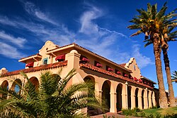
Kelso is a ghost town and defunct railroad depot in the Mojave National Preserve in San Bernardino County, California, USA. It was named after railroad worker John H. Kelso, whose name was placed into a hat along with two other workers to decide the name of the town. The town was built in 1905 specifically as a railroad station along the rail line between Utah and Los Angeles, originally called "Siding 16," because of its location and nearby springs that provided abundant water. Historic Spots in California states, "At Kelso stands a beautiful Spanish-style Union Pacific Depot built about 1906, surrounded by shade trees, a welcome rarity in the hot, barren desert." [2]

Contents

History

Starting off as what was a simple train depot in the 1920s, the town of Kelso boomed briefly to as many as 2,000 residents in the 1940s, when borax and iron mines opened nearby. Gold and silver were also discovered in the nearby hills of what became known as the Kelso district. The town shrank again when the mines closed after about a decade.

Kelso was a base of operations for the San Pedro, Los Angeles and Salt Lake Railroad, connecting track of Union Pacific Railroad, to which the SPLA&SL had negotiated trackage rights, with the Atchison, Topeka and Santa Fe Railway east-west line to the south. Here, trains were watered and "helper" locomotives were attached to assist the regular trains in climbing the steep Cima Hill. The distance between Las Vegas and the connection with the Santa Fe line at Daggett was too far for trains without a meal car, so Kelso was a convenient spot for a restaurant stop.

The depot building itself was built in 1923 using a Spanish "California mission" building style. It contained boarding rooms for railroad employees and a restaurant for both employees and passengers. It also had a telegraph office and waiting room. Later, a restaurant nicknamed the "Beanery" that served home-style meals was housed in the building. The large rooms in the basement also served as a community center for local residents.

About 1944 the railroad brought in an old strap-iron jail to detain local drunks. It is now on display just outside the Kelso Depot.[ citation needed ]

The depot remained in operation until 1986. Left to the harsh conditions in the desert, the building began to deteriorate. By the mid-1990s the railroad was on the verge of demolishing the depot. Preservationists then stepped in to save it. In 2005, it was renovated to become the Mojave National Preserve's visitor center. The facility is currently closed for repairs. Reopening is anticipated for the spring of 2023.[ citation needed ]

During the 1970s Kelso was known as "the town without television." About 75 residents lived in Kelso, many with school age children. Television signals could not reach the town which meant that residents found other methods of recreation. However, with the advent of satellite dishes, television was eventually introduced to Kelso.

The ZIP Code is 92309 and the community is inside area codes 442 and 760.

The Kelso Mountains are located north of Kelso, the Kelso Dunes lie to the southwest, and the entire area lies within the boundary of the Mojave National Preserve.

See also

Related Research Articles

<span class="mw-page-title-main">Mojave Desert</span> Desert in the southwestern United States

The Mojave Desert is a desert in the rain shadow of the southern Sierra Nevada mountains and Transverse Ranges in the Southwestern United States. Named for the indigenous Mohave people, it is located primarily in southeastern California and southwestern Nevada, with small portions extending into Arizona and Utah.

<span class="mw-page-title-main">Mojave National Preserve</span> Protected wilderness area in California, United States

Mojave National Preserve is a United States National Preserve located in the Mojave Desert of San Bernardino County, California, US, between Interstate 15 and Interstate 40. The preserve was established October 31, 1994, with the enactment of the California Desert Protection Act by the United States Congress, which also established Joshua Tree National Park and Death Valley National Park as National Parks. Previously, some lands contained within the Preserve were the East Mojave National Scenic Area, under the jurisdiction of the Bureau of Land Management. At 1,542,776 acres (6,243 km2), within the contiguous United States it is the third largest unit of the National Park System and the first largest National Preserve. The preserve was created within the Pacific West Region of the National Park Service and remains within that jurisdiction today.

<span class="mw-page-title-main">Calico, California</span> Place in California, United States

Calico is a ghost town and former mining town in San Bernardino County, California, United States. Located in the Calico Mountains of the Mojave Desert region of Southern California, it was founded in 1881 as a silver mining town, and was later converted into a county park named Calico Ghost Town. Located off Interstate 15, it lies 3 miles (4.8 km) from Barstow and 3 miles from Yermo. Giant letters spelling CALICO are visible, from the highway, on the Calico Peaks behind it. Walter Knott purchased Calico in the 1950s, and rebuilt all but the five remaining original buildings to look as they did in the 1880s. Calico received California Historical Landmark #782, and in 2005 was proclaimed by then-Governor Arnold Schwarzenegger to be California's Silver Rush Ghost Town.

<span class="mw-page-title-main">Amboy, California</span> Unincorporated community in California, United States

Amboy is an unincorporated community in San Bernardino County, in California's Mojave Desert, west of Needles and east of Ludlow on historic Route 66. It is roughly 60 miles (97 km) northeast of Twentynine Palms. As of 2020, the town's business district still contained a post office, a historic restaurant-motel, and a Route 66 tourist shop, all operated by the town's population of four people.

<span class="mw-page-title-main">Nipton, California</span> Unincorporated community in California, United States

Nipton is an unincorporated community in the Ivanpah Valley in San Bernardino County, California. With a population of about 15 – 20, it is located on the northeastern border of Mojave National Preserve, approximately 12 miles (19 km) southeast of Primm, Nevada and the Ivanpah Solar Power Facility. It is accessible via Nevada State Route 164.

<span class="mw-page-title-main">Tehachapi Loop</span> Rail line spiral between the Central Valley and Mojave Desert

The Tehachapi Loop is a 3,779-foot-long spiral, or helix, on the Union Pacific Railroad Mojave Subdivision through Tehachapi Pass, of the Tehachapi Mountains in Kern County, south-central California. The line connects Bakersfield and the San Joaquin Valley to Mojave in the Mojave Desert.

<span class="mw-page-title-main">Kelso Dunes</span> Dunefield in the Mojave Desert, United States

Kelso Dunes, also known as the Kelso Dune Field, is the largest field of aeolian sand deposits in the Mojave Desert. The region is protected by the Mojave National Preserve and is located near the town of Baker, San Bernardino County, California, and the Preserve Visitor Center. The dune field covers 45 square miles (120 km2) and includes migrating dunes, vegetation-stabilized dunes, sand sheets, and sand ramps. The tallest dunes rise up to 650 feet (200 m) above the surrounding terrain.

<span class="mw-page-title-main">Fairbank, Arizona</span> Ghost town in Cochise County, Arizona

Fairbank is a ghost town in Cochise County, Arizona, next to the San Pedro River. First settled in 1881, Fairbank was the closest rail stop to nearby Tombstone, which made it an important location in the development of southeastern Arizona. The town was named for Chicago investor Nathaniel Kellogg Fairbank who partially financed the railroad, and was the founder of the Grand Central Mining Company, which had an interest in the silver mines in Tombstone. Today Fairbank is located within the San Pedro Riparian National Conservation Area.

Bagdad is a ghost town in the Mojave Desert, in San Bernardino County, California.

<span class="mw-page-title-main">Daggett, California</span> Unincorporated community in California, United States

Daggett is an unincorporated community located in San Bernardino County, California in the United States. The town is located on Interstate 40 ten miles (16 km) east of Barstow. The town has a population of about 200. The ZIP code is 92327 and the community is inside area code 760.

Goffs, an unincorporated community in San Bernardino County, California, is a nearly empty one-time railroad town at the route's high point in the Mojave Desert. Goffs was a stop on famous U.S. Route 66 until 1931 when a more direct road opened between Needles and Essex. Goffs was also home to workers of the nearby Santa Fe Railroad, with Homer east, Fenner south, and Blackburn and Purdy north. Goffs is also known as the "Desert Tortoise Capital of the World."

<span class="mw-page-title-main">Newberry Springs, California</span> Unincorporated community in California, United States

Newberry Springs is an unincorporated community in the western Mojave Desert of Southern California, located at the foot of the Newberry Mountains in San Bernardino County, California, United States. Newberry Spring is a spring that in the 19th century supplied water to the local Santa Fe Railway and originally was a camping place. The population at the 2000 census was 2,895.

Ludlow is an unincorporated community in the Mojave Desert on Interstate 40, located in San Bernardino County, California, United States. The older remains of the ghost town are along historic Route 66.

<span class="mw-page-title-main">Barstow Harvey House</span> Train station in Barstow, California, U.S.

The Barstow Harvey House, also known as Harvey House Railroad Depot and Barstow station, is a historic building in Barstow, California. Originally built in 1911 as Casa del Desierto, a Harvey House hotel and Santa Fe Railroad depot, it currently serves as an Amtrak station and government building housing city offices, the Barstow Chamber of Commerce and Visitor Center, and two museums.

<span class="mw-page-title-main">Kelso Depot</span> United States historic place

The Kelso Depot, Restaurant and Employees Hotel or Kelso Depot, now also the Mojave National Preserve Visitors Center, is located in the Mojave Desert within the National Park Service Mojave National Preserve, on Kelso Cima Road at the junction of Kelbaker Road in Kelso, California, between Baker and Interstate 15 to the north and Interstate 40 to the south. It was placed on the National Register of Historic Places, and along with the adjacent ghost town of Kelso, was declared a United States Historic District in 2000. The district was increased by a boundary increase approved by the National Park Service in 2019, with reference number 100003401.

<span class="mw-page-title-main">El Garces Intermodal Transportation Facility</span> Railway station in Needles, California

El Garces Intermodal Transportation Facility is an Amtrak intercity rail station and bus depot in downtown Needles, California. The structure was originally built in 1908 as El Garces, a Harvey House and Atchison, Topeka and Santa Fe Railway (ATSF) station. It is named for Francisco Garcés, a Spanish missionary who surveyed the area in the 1770s. It was added to the National Register of Historic Places in 2002.

<span class="mw-page-title-main">Amargosa Opera House and Hotel</span>

Amargosa Opera House and Hotel is a historic building and cultural center located in Death Valley Junction, in eastern Inyo County, California near Death Valley National Park.

<span class="mw-page-title-main">Mission Revival architecture</span> Architectural movement and style

The Mission Revival style was part of an architectural movement, beginning in the late 19th century, for the revival and reinterpretation of American colonial styles. Mission Revival drew inspiration from the late 18th and early 19th century Spanish missions in California. It is sometimes termed California Mission Revival, particularly when used elsewhere, such as in New Mexico and Texas which have their own unique regional architectural styles. In Australia, the style is known as Spanish Mission.

Barnwell, originally a rail camp named Summit, then Manvel, was a former railhead serving local mining camps, now a ghost town, in San Bernardino County, California. It lies at an elevation 4806 feet in the New York Mountains.

References

  1. "Kelso". Geographic Names Information System . United States Geological Survey, United States Department of the Interior . Retrieved April 8, 2015.
  2. Abeloe, William N. (1966). Historic Spots in California (3rd ed.). Stanford, Calif.: Stanford University Press. p. 327.