California is a U.S. state on the western coast of North America. Covering an area of 163,696 sq mi (423,970 km2), California is geographically diverse. The Sierra Nevada, the fertile farmlands of the Central Valley, and the arid Mojave Desert of the south are some of the major geographic features of this U.S. state. It is home to some of the world's most exceptional trees: the tallest, most massive, and oldest. It is also home to both the highest and lowest points in the 48 contiguous states. The state is generally divided into Northern and Southern California, although the boundary between the two is not well defined. San Francisco is decidedly a Northern California city and Los Angeles likewise a Southern California one, but areas in between do not often share their confidence in geographic identity. The US Geological Survey defines the geographic center of the state at a point near North Fork, California.

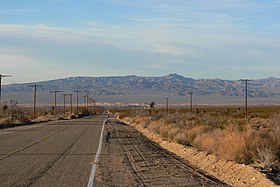
The Mojave Desert is an arid rain-shadow desert and the driest desert in North America. It is in the southwestern United States, primarily within southeastern California and southern Nevada, and it occupies 47,877 sq mi (124,000 km2). Very small areas also extend into Utah and Arizona. Its boundaries are generally noted by the presence of Joshua trees, which are native only to the Mojave Desert and are considered an indicator species, and it is believed to support an additional 1,750 to 2,000 species of plants. The central part of the desert is sparsely populated, while its peripheries support large communities such as Las Vegas, Barstow, Lancaster, Palmdale, Victorville, and St. George.

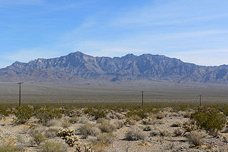
The Granite Mountains is a small mountain range in San Bernardino County, California, USA, located in the Mojave Desert. They are in the Mojave National Preserve, in the National Park Service system.
The Providence Mountains are found in the eastern Mojave Desert of San Bernardino County, California, U.S. The range reaches an elevation of 7,162 feet (2,183 m) at Edgar Peak and is home to the Mitchell Caverns Natural Preserve in the Providence Mountains State Recreation Area, and the Mojave National Preserve.

The Bristol Mountains are found in the Mojave Desert of California, USA, just west of Mojave National Preserve. The range, which reaches an elevation of 3,874 feet, is located in San Bernardino County, and crosses Interstate 40 between Ludlow and the Granite Mountains. At the southern end of the range lies the town of Amboy, the Amboy Crater, and Bristol Dry Lake.

The Chemehuevi Mountains are found at the southeast border of San Bernardino County in southeastern California adjacent the Colorado River. Located south of Needles, California and northwest of the Whipple Mountains, the mountains lie in a north-south direction in general, and are approximately 15 miles in length.
The Beale Mountains are located in the Mojave National Preserve in eastern California. The range is one of the smallest mountain ranges in the United States, and is only about 2.5 miles long. The mountains are located northeast of the Kelso Mountains, about five miles from the Kelso Cima road, in the Cinder Cone National Natural Landmark. The mountains lie in the arid climate zone, characterized by little rainfall. They are named after Edward Fitzgerald Beale.

The Shadow Mountains are located in the Mojave Desert of eastern California in the United States. The mountains lie in a generally north-south direction south of the Kingston Range and east of the Avawatz Mountains and the Silurian Hills.

The Bigelow Cholla Garden Wilderness is in the eastern Mojave Desert and within Mojave Trails National Monument, located in San Bernardino County, California.
Cima is a small unincorporated community in the Mojave Desert of San Bernardino County, California, in the United States. It lies in a mountain pass on the divide between the Ivanpah Valley and the Mojave River basin, at an elevation of 4,175 feet (1,273 m). The Ivanpah Mountains and Interstate 15 are to the north, the New York Mountains are to the east, and the Providence Mountains are to the south. To the northwest is the Cima Dome & Volcanic Field National Natural Landmark, which contains Cima Dome at 5,745 feet (1,751 m) above sea level, a prominent landmark along I-15. Cima is also home to one of the densest Yucca brevifolia forests in California, located in the Cima Dome.

The Marl Mountains are located in the Mojave National Preserve in eastern California in the United States, northeast of the Kelso Mountains. The Marl Mountains lie just east of Kelbaker Road, which connects the town of Baker with the small community of Kelso, California.

The Calico Mountains of California are a mountain range located in the Mojave Desert. The range spans San Bernardino and Inyo counties in California.

Bright Star Wilderness is a 8,190-acre (3,314 ha) wilderness area in Kern County in the U.S. state of California.
Kelbaker Road is a paved road in San Bernardino County, California, that serves as the primary and busiest route through the Mojave National Preserve. It also connects the communities of Kelso and Baker. Its southern terminus is at County Route 66 between Amboy and Chambless. Kelbaker Road's northern terminus is at Interstate 15 in Baker. The road then continues as California State Route 127 northward to Nevada, connecting to Nevada State Route 373, passing near Death Valley National Park.
Old Dad Mountain is a summit, southwest of the Cinder Cone Lava Beds, west of the Kelso Mountains, north of Jackass Canyon, northeast of the Devils Playground and east of Soda Lake, in San Bernardino County, California. The peak is at 4,121 feet / 1,256 meters. Old Dad Mountain was named in humorous contrast to the nearby Old Woman Mountains.

Castle Mountains National Monument is a U.S. National Monument located in the eastern Mojave Desert and northeastern San Bernardino County, in the state of California.

Kelso Wash is an ephemeral stream in San Bernardino County, California, United States, that drains into Soda Lake. The town of Kelso lies southeast of the wash.
Benchmark Maps is a map-publishing company based in Medford, Oregon and Santa Barbara, California. As of 2018, the company has published detailed atlases for thirteen states: Alaska, Arizona, California, Colorado, Idaho, Montana, Nevada, New Mexico, Oregon, Texas, Utah, Washington, and Wyoming. The company got its start in 1995, and has sold over two million maps and atlases. It is owned by Athenaeum Capital Partners LLC and the General Manager is John Glanville.

The International Standard Book Number (ISBN) is a numeric commercial book identifier which is intended to be unique. Publishers purchase ISBNs from an affiliate of the International ISBN Agency.