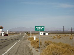
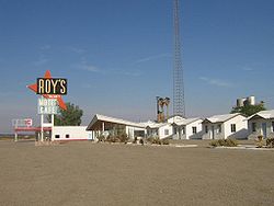
Town Other names County Latitude/Longitude Founded Abandoned Status Remarks Agua Fria Mariposa 37°29′06″N 120°01′13″W / 37.48500°N 120.02028°W / 37.48500; -120.02028 1850 1862 [ 1] Barren [ 2] Truly was abandoned after a fire burnt down the town in 1866. Agua Mansa San Bernardino 34°02′31″N 117°21′50″W / 34.04194°N 117.36389°W / 34.04194; -117.36389 1853 After 1862 [ 3] Barren [ 4] Declined slowly after the Great Flood of 1862 . [ 3] Alma Lexington [ 5] Santa Clara 37°10′48″N 121°58′48″W / 37.18000°N 121.98000°W / 37.18000; -121.98000 1861 1952 Submerged Already declined to less than 100 residents, Alma was demolished during the 1952 construction of the James J. Lenihan Dam . Currently, the few remaining structures are underneath the Lexington Reservoir and can only be seen during low water levels. [ 6] Amboy San Bernardino 34°33′25″N 115°44′42″W / 34.55694°N 115.74500°W / 34.55694; -115.74500 1858 N/A Semi-abandoned declined slowly from the opening of Interstate 40 Ashford Mill Inyo 35°55′08″N 116°41′05″W / 35.91889°N 116.68472°W / 35.91889; -116.68472 1914 unknown Neglected Ash Hill San Bernardino 34°42′25″N 116°03′18″W / 34.70694°N 116.05500°W / 34.70694; -116.05500 unknown unknown Neglected Asphalto La Brea Kern 35°18′17″N 119°36′03″W / 35.30472°N 119.60083°W / 35.30472; -119.60083 Before 1893 1932 Barren Atolia San Bernardino 35°18′53″N 117°36′33″W / 35.31472°N 117.60917°W / 35.31472; -117.60917 1906 After 1965 Abandoned Bagdad San Bernardino 34°34′58″N 115°52′32″W / 34.58278°N 115.87556°W / 34.58278; -115.87556 1883 1973 Barren [ 7] Abandoned due to opening of Interstate 40 Ballarat Inyo 36°02′52″N 117°13′24″W / 36.04778°N 117.22333°W / 36.04778; -117.22333 1897 1968 Neglected The Manson Family left graffiti here. The town became abandoned after its sole resident, who had been living there alone for five decades, died Beeks Place Orange 33°49′14″N 117°38′20″W / 33.82049°N 117.63878°W / 33.82049; -117.63878 Before 1940 unknown Abandoned Belleville San Bernardino 34°18′4″N 116°53′3″W / 34.30111°N 116.88417°W / 34.30111; -116.88417 1860 Before 1900 Abandoned Slowly declined after gold deposits in the region dried up Bennettville Tioga Mono 37°56′15″N 119°15′38″W / 37.93750°N 119.26056°W / 37.93750; -119.26056 1860 1890 Abandoned Abandoned after not enough silver was found in the region Bend City Inyo 36°49′09″N 118°07′50″W / 36.81917°N 118.13056°W / 36.81917; -118.13056 1863 After 1872 Abandoned the 1872 Owens Valley Earthquake caused the Owens River to flow away from the town, driving the last remaining residents out Bestville Siskiyou 41°18′03″N 123°08′35″W / 41.3007°N 123.1431°W / 41.3007; -123.1431 1850 unknown Barren Blue Mountain City Calaveras 38°22′15″N 120°21′59″W / 38.37080°N 120.36642°W / 38.37080; -120.36642 1863 unknown Barren Bodie Mono 38°12′44″N 119°00′44″W / 38.21222°N 119.01222°W / 38.21222; -119.01222 1876 N/A Semiabandoned Declined slowly from mining profits decreasing since 1914 Branson City Branson San Diego 33°04′41″N 116°37′02″W / 33.07806°N 116.61722°W / 33.07806; -116.61722 1870 unknown Abandoned Abandoned due to not being able to compete with nearby Julian Cadiz San Bernardino 34°31′12″N 115°30′46″W / 34.52000°N 115.51278°W / 34.52000; -115.51278 1883 unknown Neglected Calico San Bernardino 34°56′56″N 116°51′51″W / 34.94889°N 116.86417°W / 34.94889; -116.86417 1881 1907 Abandoned [ 8] Abandoned due to an end to borax mining in the region Camanche Clay's Bar Calaveras 38°12′48″N 120°56′07″W / 38.21333°N 120.93528°W / 38.21333; -120.93528 Before 1849 After 1962 Submerged Inundated by Camanche Reservoir Canon City Trinity 40°49′53″N 123°03′10″W / 40.83139°N 123.05278°W / 40.83139; -123.05278 1851 1891 Barren Carnegie San Joaquin 37°37′46″N 121°31′41″W / 37.62951°N 121.52797°W / 37.62951; -121.52797 1902 1915 Neglected Slowly declined after a flood in 1911 destroyed many roads and buildings as well. Carson Hill Slumgullion Calaveras 38°01′42″N 120°30′24″W / 38.02833°N 120.50667°W / 38.02833; -120.50667 Before 1853 1935 Abandoned Cement Solano 38°17′34″N 121°59′46″W / 38.29278°N 121.99611°W / 38.29278; -121.99611 1902 1927 Neglected Slowly declined after limestone deposits in the region were depleted. Cerro Gordo Inyo 36°32.2626′N 117°47.70186′W / 36.5377100°N 117.79503100°W / 36.5377100; -117.79503100 1866 N/A Semiabandoned One man has been living here since 2020, after everyone else left. Chinquapin Chincapin Mariposa 37°39′00″N 119°42′19″W / 37.65000°N 119.70528°W / 37.65000; -119.70528 1882 N/A Semiabandoned Still used as a rest stop and ranger station within Yosemite National Park Chloride City Inyo 36°42′24″N 116°52′56″W / 36.70667°N 116.88222°W / 36.70667; -116.88222 1905 unknown Neglected Chrysopolis Inyo 36°57′38″N 118°11′48″W / 36.96056°N 118.19667°W / 36.96056; -118.19667 1863 1910 Neglected Abandoned after a mining boom in the region started in 1900, it went away. Coleman City Emily City San Diego 33°05′10″N 116°38′42″W / 33.08611°N 116.64500°W / 33.08611; -116.64500 1870 unknown Abandoned Abandoned after depletion of gold deposits in the region Coso Granite Springs Inyo 36°10′36″N 117°38′49″W / 36.17667°N 117.64694°W / 36.17667; -117.64694 1860 unknown Barren Cox & Clark Trading Post Kings 35°58′08″N 119°56′21″W / 35.96898°N 119.93929°W / 35.96898; -119.93929 1870 unknown Barren Cuyamaca City ’Ekwiiyemak San Diego 32°59′05″N 116°34′15″W / 32.98472°N 116.57083°W / 32.98472; -116.57083 1887 1906 Abandoned Deadwood Placer 39°04′50″N 120°41′22″W / 39.08056°N 120.68944°W / 39.08056; -120.68944 1852 unknown Abandoned Deadwood Trinity 40°43′10″N 122°44′01″W / 40.71944°N 122.73361°W / 40.71944; -122.73361 1851 1915 Abandoned Abandoned with the closing of the town's post office Dedrick Trinity 40°51′46″N 123°02′12″W / 40.86278°N 123.03667°W / 40.86278; -123.03667 1890 After 1941 Abandoned Denny Trinity 40°56′38″N 123°23′12″W / 40.94389°N 123.38667°W / 40.94389; -123.38667 After 1851 After 1970 Abandoned Desert Spring Kern 35°16′20″N 118°37′34″W / 35.27222°N 118.62611°W / 35.27222; -118.62611 Before 1834 After 1850 Barren Dogtown Dogtown Diggings Mono 38°10′13″N 119°11′51″W / 38.17028°N 119.19750°W / 38.17028; -119.19750 1857 After 1859 Barren Drawbridge Saline City Alameda 37°27′54″N 121°58′28″W / 37.46500°N 121.97444°W / 37.46500; -121.97444 1876 1979 Abandoned Population slowly declined due to the closing of nearby bridges and rampant vandalism in the town. Dunmovin Cowan Station Inyo 36°05′19″N 117°57′40″W / 36.08861°N 117.96111°W / 36.08861; -117.96111 Before 1936 N/A Semi-abandoned Eagle Mountain Riverside 33°51′27″N 115°29′14″W / 33.85750°N 115.48722°W / 33.85750; -115.48722 1948 2003 Abandoned A jailbreak at the Eagle Mountain Community Correctional Facility caused the prison to be shut down and the last population of the town to leave Eastwood San Diego 33°05′15″N 116°36′40″W / 33.08750°N 116.61111°W / 33.08750; -116.61111 unknown unknown Barren Eldoradoville Los Angeles 34°13′47″N 117°46′11″W / 34.2297°N 117.7698°W / 34.2297; -117.7698 1859 1862 Barren Town was washed away during the Great Flood Of 1862 . Elliott San Joaquin 38°14′05″N 121°10′51″W / 38.23472°N 121.18083°W / 38.23472; -121.18083 1846 [ 9] After 1901 Abandoned Empire City Stanislaus 37°38.239′N 120°54.167′W / 37.637317°N 120.902783°W / 37.637317; -120.902783 1850 1862 Barren The town was washed away during the Great Flood of 1862. Essex San Bernardino 34°44′01″N 115°14′42″W / 34.73361°N 115.24500°W / 34.73361; -115.24500 Before 1937 N/A Semi-abandoned Declined slowly due to the opening of Interstate 40 as well as the remoteness of the town. Falk Humboldt Fountain Springs Tulare 35°53′28″N 118°54′56″W / 35.891111°N 118.915556°W / 35.891111; -118.915556 Freeman Junction Kern 35°36′06″N 117°54′11″W / 35.60166°N 117.90295°W / 35.60166; -117.90295 Fremont Valley Calaveras French Flat Tuolumne 37°58′20″N 120°28′17″W / 37.97222°N 120.47139°W / 37.97222; -120.47139 Furnace Inyo 36°11′29″N 116°39′54″W / 36.19133°N 116.66495°W / 36.19133; -116.66495 Furnace Creek Inn Inyo 36°27′02″N 116°51′08″W / 36.45056°N 116.85222°W / 36.45056; -116.85222 Garlock Kern 35°24′09″N 117°47′24″W / 35.40250°N 117.79000°W / 35.40250; -117.79000 Gas Point Shasta 40°24′56″N 122°32′04″W / 40.41556°N 122.53444°W / 40.41556; -122.53444 Gibsonville Sierra 39°44′25″N 120°54′32″W / 39.74028°N 120.90889°W / 39.74028; -120.90889 Girard Kern Glenburn Kern 43°38′19″N 116°14′28″W / 43.63861°N 116.24111°W / 43.63861; -116.24111 Goffs San Bernardino 34°55′09″N 115°03′46″W / 34.91917°N 115.06278°W / 34.91917; -115.06278 Gold Town Kern 35°00′06″N 118°10′08″W / 35.00167°N 118.16889°W / 35.00167; -118.16889 Goler Heights Kern 35°25′37″N 117°44′45″W / 35.42694°N 117.74583°W / 35.42694; -117.74583 Greasertown Calaveras 38°11′28″N 120°45′15″W / 38.19113°N 120.75407°W / 38.19113; -120.75407 Greenwater Inyo 36°10′46″N 116°36′59″W / 36.17944°N 116.61639°W / 36.17944; -116.61639 Greenwich Kern Gerstley Inyo 36°00′43″N 116°16′28″W / 36.01190°N 116.27456°W / 36.01190; -116.27456 Grub Gulch Madera 37°19′29″N 119°46′15″W / 37.32472°N 119.77083°W / 37.32472; -119.77083 Gullion's Bar Siskiyou 41°17′48″N 123°21′36″W / 41.29667°N 123.36000°W / 41.29667; -123.36000 Haiwee Inyo 36°08′48″N 117°58′33″W / 36.14667°N 117.97583°W / 36.14667; -117.97583 Hamilton Butte 39°27′09″N 121°38′28″W / 39.45254°N 121.64108°W / 39.45254; -121.64108 Hart San Bernardino 35°17′20″N 115°06′12″W / 35.28889°N 115.10333°W / 35.28889; -115.10333 Hatfields Camp Kern 35°28′26″N 117°52′06″W / 35.47389°N 117.86833°W / 35.47389; -117.86833 Hector San Bernardino 34°48′13″N 116°27′08″W / 34.80361°N 116.45222°W / 34.80361; -116.45222 around 1937 unknown Semiabandoned Helena Trinity 40°46′25″N 123°07′42″W / 40.77361°N 123.12833°W / 40.77361; -123.12833 Hoboken Sacramento 38°33′28″N 121°25′04″W / 38.55778°N 121.41778°W / 38.55778; -121.41778 Hodson Calaveras 37°59′48″N 120°41′08″W / 37.99667°N 120.68556°W / 37.99667; -120.68556 Hokokwito Mariposa 37°45′30″N 119°35′43″W / 37.75833°N 119.59528°W / 37.75833; -119.59528 Holy City Santa Clara 37°09′25″N 121°58′44″W / 37.1568904°N 121.9788476°W / 37.1568904; -121.9788476 Hope Valley Alpine Horseshoe Bend Mariposa 37°40′41″N 120°13′52″W / 37.67794°N 120.23101°W / 37.67794; -120.23101 Hollands Los Angeles [ 10] Igo Shasta 40°30′20″N 122°32′30″W / 40.505556°N 122.541667°W / 40.505556; -122.541667 Independence Flat Calaveras [ citation needed ] Indian Gulch Mariposa 37°26′22″N 120°11′49″W / 37.43944°N 120.19694°W / 37.43944; -120.19694 Indian Springs Kern Iowa Hill Placer 39°06′31″N 120°51′34″W / 39.10861°N 120.85944°W / 39.10861; -120.85944 Isabella Kern 35°39′20″N 118°27′40″W / 35.65556°N 118.46111°W / 35.65556; -118.46111 Ivanpah San Bernardino 35°32′42″N 115°32′07″W / 35.54500°N 115.53528°W / 35.54500; -115.53528 Jaeger City Imperial 32°43′52″N 114°37′47″W / 32.73111°N 114.62972°W / 32.73111; -114.62972 Joe Walker Town Kern 35°25′20″N 118°29′35″W / 35.42222°N 118.49306°W / 35.42222; -118.49306 Joyfull Kern Kasson Inyo Kern River Slough Kern 35°15′35″N 118°58′03″W / 35.25972°N 118.96750°W / 35.25972; -118.96750 Kernvale Kern Kernville Kern 35°42′51″N 118°26′12″W / 35.71417°N 118.43667°W / 35.71417; -118.43667 Kearsarge Inyo 36°48′36″N 118°19′30″W / 36.81000°N 118.32500°W / 36.81000; -118.32500 Keeler Inyo 36°29′14″N 117°52′26″W / 36.48722°N 117.87389°W / 36.48722; -117.87389 Kelso San Bernardino 35°00′45″N 115°39′13″W / 35.01250°N 115.65361°W / 35.01250; -115.65361 Kingston Kings 36°25′25″N 119°41′38″W / 36.42361°N 119.69389°W / 36.42361; -119.69389 Kumaini Mariposa La Panza San Luis Obispo 35°21′40″N 120°12′56″W / 35.36111°N 120.21556°W / 35.36111; -120.21556 Langdon Kern Lavers' Crossing Kern 35°44′12″N 118°43′16″W / 35.73667°N 118.72111°W / 35.73667; -118.72111 Leadfield Inyo 36°50′48″N 117°03′33″W / 36.84667°N 117.05917°W / 36.84667; -117.05917 Lee Inyo 36°34′46″N 116°40′12″W / 36.57944°N 116.67000°W / 36.57944; -116.67000 Lee Camp Kern Leliter Kern 35°42′38″N 117°49′49″W / 35.71056°N 117.83028°W / 35.71056; -117.83028 Leon Riverside 33°39′09″N 117°08′08″W / 33.65250°N 117.13556°W / 33.65250; -117.13556 Lexington Santa Clara 37°11′47″N 121°59′18″W / 37.19639°N 121.98833°W / 37.19639; -121.98833 Liberty San Joaquin Linda Rosa Riverside Lila C Inyo 36°14′36″N 116°29′56″W / 36.24333°N 116.49889°W / 36.24333; -116.49889 Lillis Fresno 36°26′18″N 119°43′03″W / 36.43833°N 119.71750°W / 36.43833; -119.71750 Little Cienega La Cienega, Falling Springs Los Angeles 34°18′06″N 117°50′21″W / 34.30167°N 117.83917°W / 34.30167; -117.83917 before 1934 after 1998 Barren Former resort town most recently occupied by a religious group. Remnants mostly destroyed by the Curve Fire . Llano del Rio Los Angeles 34°30′23″N 117°49′38″W / 34.50639°N 117.82722°W / 34.50639; -117.82722 Lone Pine Station Inyo Lookout City Inyo 36°14′45″N 117°26′05″W / 36.24583°N 117.43472°W / 36.24583; -117.43472 Lower Calaveritas Calaveras Ludlow San Bernardino 34°43′16″N 116°09′36″W / 34.72111°N 116.16000°W / 34.72111; -116.16000 Lyons Station Los Angeles 34°21′46″N 118°30′27″W / 34.36270°N 118.50740°W / 34.36270; -118.50740 Macheto Mariposa Mammoth City Mono Manchester Monterey Malakoff Nevada Manzanar Inyo 36°44′24″N 118°04′50″W / 36.74000°N 118.08056°W / 36.74000; -118.08056 Martensdale Kern Martinez Tuolumne County 38°01′24″N 120°22′47″W / 38.02333°N 120.37972°W / 38.02333; -120.37972 Masonic Mono 38°21′45″N 119°06′45″W / 38.36250°N 119.11250°W / 38.36250; -119.11250 Melones Calaveras 38°00′45″N 120°29′55″W / 38.01250°N 120.49861°W / 38.01250; -120.49861 Mentryville Los Angeles 34°22′44″N 118°36′40″W / 34.379°N 118.611°W / 34.379; -118.611 Merced Falls Merced 37°31′23″N 120°19′57″W / 37.52306°N 120.33250°W / 37.52306; -120.33250 Mercuryville Sonoma 38°46′34″N 122°50′22″W / 38.77611°N 122.83944°W / 38.77611; -122.83944 Midland Riverside 33°51′40″N 114°48′08″W / 33.86111°N 114.80222°W / 33.86111; -114.80222 Midway Kern Mill Valley Calaveras Minear Mariposa Minersville Trinity 40°51′05″N 122°46′59″W / 40.85139°N 122.78306°W / 40.85139; -122.78306 Mount Ophir Mariposa 37°30′53″N 120°03′53″W / 37.51472°N 120.06472°W / 37.51472; -120.06472 Miramonte Kern Mono Mills Mono 37°53′15″N 118°57′34″W / 37.88750°N 118.95944°W / 37.88750; -118.95944 Monterio Kern Moore's Flat Nevada Mormon Island Sacramento 38°42′13″N 121°07′03″W / 38.7035°N 121.1174°W / 38.7035; -121.1174 1848 1856 Submerged Mountain House Kern 35°41′31″N 118°55′03″W / 35.69186°N 118.91759°W / 35.69186; -118.91759 Muroc Kern 34°55′23″N 117°52′20″W / 34.92306°N 117.87222°W / 34.92306; -117.87222 Narka Inyo 35°53′52″N 117°54′04″W / 35.89778°N 117.90111°W / 35.89778; -117.90111 Negro Flat Siskiyou 41°14′31″N 123°16′51″W / 41.24194°N 123.28084°W / 41.24194; -123.28084 Neuralia Inyo New Almaden Santa Clara 37°10′48″N 121°50′08″W / 37.18000°N 121.83556°W / 37.18000; -121.83556 New Idria San Benito 36°25′1″N 120°40′28″W / 36.41694°N 120.67444°W / 36.41694; -120.67444 Newtown Mariposa 37°42′12″N 120°11′31″W / 37.70333°N 120.19194°W / 37.70333; -120.19194 Noonday Camp Inyo 35°48′39″N 116°06′15″W / 35.81083°N 116.10417°W / 35.81083; -116.10417 Norristown Sacramento 38°33′28″N 121°25′04″W / 38.55778°N 121.41778°W / 38.55778; -121.41778 North Muroc Kern 35°00′18″N 117°49′08″W / 35.00500°N 117.81889°W / 35.00500; -117.81889 North Shore Riverside 33°30′46″N 115°55′38″W / 33.51278°N 115.92722°W / 33.51278; -115.92722 Nortonville Contra Costa 37°57′28″N 121°52′50″W / 37.95778°N 121.88056°W / 37.95778; -121.88056 Notomidula Mariposa Olig Kern 35°19′30″N 119°39′23″W / 35.32500°N 119.65639°W / 35.32500; -119.65639 Oregon Bar Calaveras Oregon City Butte 39°35′38″N 121°31′46″W / 39.59389°N 121.52944°W / 39.59389; -121.52944 Owensville Inyo 37°24′03″N 118°20′44″W / 37.40083°N 118.34556°W / 37.40083; -118.34556 Packwood Station Tulare Panamint City Inyo 36°07′06″N 117°05′43″W / 36.11833°N 117.09528°W / 36.11833; -117.09528 Pasinogna San Bernardino 33°59′24″N 117°43′03″W / 33.99000°N 117.71750°W / 33.99000; -117.71750 Patchen Santa Clara Petersburg Kern 35°36′09″N 118°36′13″W / 35.60250°N 118.60361°W / 35.60250; -118.60361 Petroleopolis Los Angeles Picacho Imperial 33°01′23″N 114°36′40″W / 33.02306°N 114.61111°W / 33.02306; -114.61111 Pinacate Riverside 33°45′36″N 117°14′00″W / 33.76000°N 117.23333°W / 33.76000; -117.23333 Pioneertown San Bernardino Piute Kern Politana San Bernardino Port Chicago Contra Costa 38°02′46″N 122°01′15″W / 38.04611°N 122.02083°W / 38.04611; -122.02083 Port Wine Sierra Prado San Bernardino Prairie City Sacramento Providence San Bernardino 34°58′49″N 115°30′19″W / 34.98028°N 115.50528°W / 34.98028; -115.50528 Purissima San Mateo 37°24′11″N 122°25′01″W / 37.40306°N 122.41694°W / 37.40306; -122.41694 1868 early 1900s Barren Declined slowly due to declined of Redwood Lumber industry, and failure of the Ocean Shore Railroad Pylema Kern Quartzburg Kern Quartzburg Mariposa 37°32′22″N 120°12′16″W / 37.53944°N 120.20444°W / 37.53944; -120.20444 Ragtown San Bernardino 34°39′36″N 116°09′03″W / 34.66000°N 116.15083°W / 34.66000; -116.15083 after 1898 unknown Barren Rincon San Bernardino Randsburg Kern Reefer City Kern 35°00′21″N 118°11′06″W / 35.00583°N 118.18500°W / 35.00583; -118.18500 Reilly Inyo 36°00′25″N 117°22′08″W / 36.00694°N 117.36889°W / 36.00694; -117.36889 Rice San Bernardino 34°05′01″N 114°50′59″W / 34.08361°N 114.84972°W / 34.08361; -114.84972 Ridleys Ferry Mariposa Rincon San Bernardino Rio Bravo Kern 35°17′49″N 119°03′24″W / 35.29684°N 119.05678°W / 35.29684; -119.05678 Riverview Kern Roachville Inyo Rock Springs Kern Sablon Rudolph San Bernardino 34°10′29″N 114°59′39″W / 34.17472°N 114.99417°W / 34.17472; -114.99417 1909 unknown Barren Sage Kern San Carlos Inyo 36°48′14″N 118°07′34″W / 36.80389°N 118.12611°W / 36.80389; -118.12611 (San Carlos, Inyo County, California ) San Joaquin City San Joaquin 37°40′12″N 121°15′58″W / 37.67000°N 121.26611°W / 37.67000; -121.26611 San Miguel de los Noches Kern Sakaya Mariposa Salmon Falls El Dorado 38°45′29″N 121°03′30″W / 38.75806°N 121.05833°W / 38.75806; -121.05833 1850 1950s Submerged California State Historical Marker #571 Saltus San Bernardino 34°32′27″N 115°41′20″W / 34.54083°N 115.68889°W / 34.54083; -115.68889 unknown unknown Abandoned Supported salt evaporation. Notable for an unverified claim to the hottest temperature ever recorded. Sandy Bar Calaveras Sawmill Flat Tuolumne 38°01′14″N 120°22′51″W / 38.02056°N 120.38083°W / 38.02056; -120.38083 Scheelite Inyo Schwaub Inyo 36°30′20″N 116°43′25″W / 36.50556°N 116.72361°W / 36.50556; -116.72361 Scovern Hot Springs Kern 35°37′17″N 118°28′27″W / 35.62139°N 118.47417°W / 35.62139; -118.47417 Second Garrotte Tuolumne 37°49′30″N 120°11′51″W / 37.82500°N 120.19750°W / 37.82500; -120.19750 Seneca Plumas 40°06′38″N 121°05′05″W / 40.11056°N 121.08472°W / 40.11056; -121.08472 Shamrock Kern Shasta Shasta 40°35′32″N 122°28′40″W / 40.59222°N 122.47778°W / 40.59222; -122.47778 Siberia San Bernardino 34°37′36″N 115°59′09″W / 34.62667°N 115.98583°W / 34.62667; -115.98583 Silver Mountain Alpine Silver City , Tulare County, California|Tulare]] Tulare 36°27′50″N 118°39′03″W / 36.46389°N 118.65083°W / 36.46389; -118.65083 Silver Lake San Bernardino 35°22′16″N 116°6′54″W / 35.37111°N 116.11500°W / 35.37111; -116.11500 Skidoo Inyo 36°26′08″N 117°08′51″W / 36.43556°N 117.14750°W / 36.43556; -117.14750 Sloss Mariposa Smyrna Kern Sodan Inyo 35°55′16″N 117°54′10″W / 35.92111°N 117.90278°W / 35.92111; -117.90278 Sorrell's Kern Spanish Bar Calaveras St. Louis Sierra Stedman Steadman, Rochester, Copenhagen San Bernardino 34°37′45″N 116°10′13″W / 34.62917°N 116.17028°W / 34.62917; -116.17028 1898 1930s Neglected Abandoned when the Bagdad-Chase Mine went into receivership. Stickneys Ferry Tulare Stonewall San Diego Stony Bar Calaveras Strader Kern Strand Kern Stratton San Diego Styx Riverside 33°52′41″N 114°47′42″W / 33.87806°N 114.79500°W / 33.87806; -114.79500 unknown unknown Semiabandoned Sullivan Kern Sunland Inyo 37°19′57″N 118°24′16″W / 37.33250°N 118.40444°W / 37.33250; -118.40444 Sunset Kern Swansea Inyo 36°31′29″N 117°54′14″W / 36.52472°N 117.90389°W / 36.52472; -117.90389 Taylors Bar Calaveras Teagle Kern Tehichipa Kern Tejon Kern Telegraph City Grasshopper City Calaveras 37°56′04″N 120°44′24″W / 37.934444°N 120.74°W / 37.934444; -120.74 1860 Neglected Temescal Riverside Terese Siding Kern Terra Cotta Riverside 33°42′11″N 117°22′29″W / 33.70306°N 117.37472°W / 33.70306; -117.37472 Timbuctoo Yuba 39°13′01″N 121°19′07″W / 39.21694°N 121.31861°W / 39.21694; -121.31861 Toolwass Kern Tumco Imperial Unadilla Kern Vaca Adobe Kings 36°03′08″N 119°57′52″W / 36.05222°N 119.96435°W / 36.05222; -119.96435 Vallecito San Diego 32°58′34″N 116°21′01″W / 32.97611°N 116.35028°W / 32.97611; -116.35028 Valley Wells San Bernardino 35°49′42″N 117°19′54″W / 35.82833°N 117.33167°W / 35.82833; -117.33167 Vanderbilt San Bernardino 35°19′38″N 115°14′59″W / 35.32722°N 115.24972°W / 35.32722; -115.24972 Vaughn Kern Water Station Kern Wenger Mariposa Westville Placer 39°10′30″N 120°38′53″W / 39.17500°N 120.64806°W / 39.17500; -120.64806 White Mountain City Inyo Willard Riverside Wingo Sonoma 38°12′33″N 122°25′36″W / 38.20917°N 122.42667°W / 38.20917; -122.42667 Winter Garden Kern Wiskala Mariposa Woodfords Alpine Woolsey Flat Nevada 39°24′41″N 120°52′05″W / 39.41139°N 120.86806°W / 39.41139; -120.86806 Wrights Santa Clara 37°08′21″N 121°56′49″W / 37.13917°N 121.94694°W / 37.13917; -121.94694 Yaqui Camp Calaveras You Bet Nevada 39°12′33″N 120°54′00″W / 39.20917°N 120.90000°W / 39.20917; -120.90000 A gold mining town Zurich Alvord, Station [ 11] Inyo 37°10′58″N 118°15′36″W / 37.18278°N 118.26000°W / 37.18278; -118.26000