Vernon Parish is a parish located in the U.S. state of Louisiana. As of the 2020 census, the population was 48,750. The parish seat and most populous municipality is Leesville. Bordered on the west by the Sabine River, the parish was founded in 1871 during the Reconstruction era.

Sabine Parish is a parish located in the U.S. state of Louisiana. As of the 2020 census, the population was 22,155. The parish seat and largest town is Many.

U.S. Highway 171 (US 171) is a part of the United States Numbered Highway System and the only route within that system currently located entirely within the state of Louisiana. It spans 177.44 miles (285.56 km) in a north–south direction from the junction of US 90 and Louisiana Highway 14 (LA 14) in Lake Charles to the junction of US 79/US 80 and LA 3094 in Shreveport.

Louisiana Highway 8 is a state highway in Louisiana. It spans 156 miles (251 km) beginning at the Louisiana/Texas state line west of Leesville and ending at an intersection with U.S. Route 425 and LA 15 in Sicily Island.

Louisiana Highway 10 (LA 10) is a state highway located in southern Louisiana. It runs 255.51 miles (411.20 km) in an east–west direction from U.S. Highway 171 (US 171) south of Leesville to the Mississippi state line east of Bogalusa.

The Louisiana Circuit Courts of Appeal are the intermediate appellate courts for the state of Louisiana.

Louisiana Highway 111 (LA 111) is a state highway located in western Louisiana. It runs 45.72 miles (73.58 km) in a general north–south direction from U.S. Highway 190 (US 190) in Junction to LA 117 northeast of Leesville.
Alco was a sawmill town in Vernon Parish, Louisiana, United States. It was located on the Red River and Gulf Railroad, 50 miles from Alexandria.

The 1976 United States presidential election in Louisiana took place on November 2, 1976, as part of the 1976 United States presidential election. State voters chose ten representatives, or electors, to the Electoral College, who voted for president and vice president.

The state of Louisiana has 42 district courts, with each serving at least one parish.

The 1972 United States presidential election in Louisiana took place on November 7, 1972. All 50 states and the District of Columbia were part of the 1972 United States presidential election. State voters chose ten electors to the Electoral College, who voted for president and vice president.

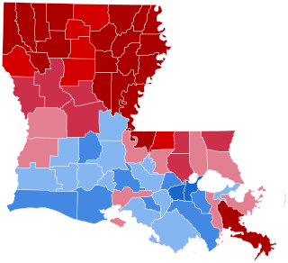
The 1968 United States presidential election in Louisiana was held on November 5, 1968, as part of the 1968 United States presidential election. Along with four other contiguous southern states, former and future Alabama Governor George Wallace won the state for the American Party by a large margin against Democrat Hubert Humphrey and Republican Richard Nixon. As of the 2020 presidential election, this is the last election in which Jefferson Parish, St. Tammany Parish, Lafayette Parish, Ouachita Parish, Bossier Parish, Union Parish, and LaSalle Parish did not vote for the Republican presidential candidate.

The 1964 United States presidential election in Louisiana took place on November 3, 1964, as part of the 1964 United States presidential election. Louisiana voters chose ten representatives, or electors, to the Electoral College, who voted for president and vice president.
Fort Johnson North Wildlife Management Area, known locally as Peason Ridge WMA, is a 74,309-acre tract of protected area located in the Parishes of Natchitoches, Sabine, and Vernon, in the state of Louisiana. The WMA is managed by the Louisiana Department of Wildlife and Fisheries (LDWF).
Peason is a small populated community and sawmill ghost town located on Louisiana highway 118 approximately 8.7 miles (14.0 km) east of Hornbeck, and the sawmill ghost town of Sandel, in Sabine Parish, Louisiana.

William Russell Pickering (1849–1927), referred to as W. R. Pickering, was an American miner, lumber baron, developer, railroad owner and banker. From his first business adventure in mining lead, in Joplin, Missouri in 1872, and his partnership with Ellis Short in the merchandise business at Joplin, the empire grew across several states, including Missouri, Arkansas, Indian Territory, Louisiana, Texas, and California.